
Order Total (1 Item Items):
Shipping Destination:

Hassenstein a (55 results)
Skip to main search results
Search filters
Product Type
- All Product Types
- Books (32)
- Magazines & Periodicals (No further results match this refinement)
- Comics (No further results match this refinement)
- Sheet Music (No further results match this refinement)
- Art, Prints & Posters (No further results match this refinement)
- Photographs (No further results match this refinement)
- Maps (23)
- Manuscripts & Paper Collectibles (No further results match this refinement)
Condition Learn more
- New (15)
- As New, Fine or Near Fine (3)
- Very Good or Good (28)
- Fair or Poor (No further results match this refinement)
- As Described (9)
Binding
Collectible Attributes
Language (3)
Free Shipping
Seller Location
Seller Rating
-

Das Tabu der Gewalt - Band I. (Neuwertiger Zustand)
Language: Italian
Published by Laterza Verlag;, 1986
Seller: books4less (Versandantiquariat Petra Gros GmbH & Co. KG), Welling, Germany
Seller rating 5 out of 5 stars

Broschiert; Condition: Gut. 303 Seiten; Das Buch befindet sich in einem neuwertig erhaltenen Zustand und ist noch original eingeschwei�t. Sprache: Italienisch Gewicht in Gramm: 370.
-
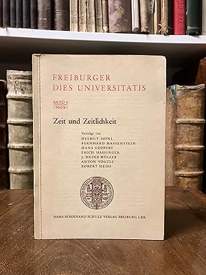
Zeit und Zeitlichkeit. (= Freiburger Dies Universitatis, Band 8).
Language: German
Published by Hans Ferdinand Schulz, Freiburg, 1961
Softcover. Condition: Gut. OBrosch., 8�, 131 S., guter Zustand.
-

Kybernetik - Br�cke zwischen den Wissenschaften.
Published by Umschau Verlag, Frankfurt a. M., 1964
Seller: Musikantiquariat Staub, Leipzig, Germany
Association Member: BOEV
Seller rating 5 out of 5 stars
Signed
Dust Jacket Condition: Gut. Jahr: 1964. Einband: Broschur. Beschreibung: 1964 - 24 Beitr�ge namhafter Wissenschaftler u. Ingenieure. Hrsg. von Helmar Frank. Einband nachgedunkelt. Innen gut und sauber erhalten. Sprache: de. 241 S. 4 grundlegend �berarbeitete u erheblich erweiterte Auflage. Widmung des Illustrators.
-

HANDBUCH DER ASTROPHYSIK, BAND II, ERSTE & ZWEITE TEILE, I & II (1 & 2): Grundlagen der Astrophysik.
Language: German
Published by Verlag von Julius Springer, 1931
Seller: Avenue Victor Hugo Books, Newmarket, NH, U.S.A.
Seller rating 5 out of 5 stars
First Edition
Hardcover. Condition: Very Good. First Edition. Text in German. 2 vols. Quarto, 10" tall, vol. 1: pages 430 with 134 illustrations; vol. 2: pages 431 to 752 with 85 illustrations and 2 fold-out charts, brown cloth. Volume two is fine with light shelf wear, volume one very good with light shelf wear, but a light exterior moisture stain to the spine, hinges, and binding of both sold, paper just slightly yellowed interiors fine. Note: Overseas shipping is quite expensive at present and likely more than the cost of the book.
-
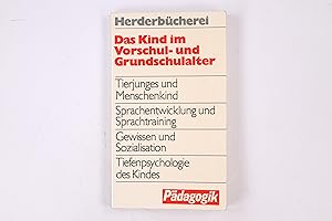
DAS KIND IM VORSCHUL- UND GRUNDSCHULALTER
Seller: Butterfly Books GmbH & Co. KG, Herzebrock-Clarholz, Germany
Seller rating 5 out of 5 stars
Taschenbuch oder Softcover. Condition: Gut. 202 Seiten Zustand: GUTER Zustand. HC1-022-6/8-00036479 Sprache: Deutsch Gewicht in Gramm: 151.
-
1881 Map of East Griqua and Pondo Land based on C. Henkel's Map and Other Sources. Also an inset: Mouth of the Umzimvubu (St. John's River).
Language: German
Published by Justus Perthes, Gotha, 1881
Map
No Binding. Condition: Very Good. Bruno Hassenstein (illustrator). In German: Ost-Griqua und Pondo-Land nach C. Henkel's Karte und Anderen Quellen. Inset: Mundung des Umzimvubu.Cream and brown base map with geopolitical boundaries tinted pink. From "Mittheilungen aus Justus Perthes' Geographischer Anstalt uber Wichtige Neue Erforschungen auf dem Gessammtgebiete der Geographie von Dr. A. Petermann, 1881." Roughly: "Communications from Justus Perthes' Geographical Institute Concerning Important New Studies in the Whole Field of Geography by Dr. Augustus Petermann, 1881." Condition notes: 8.5" wide X 10.8" high, mildly toned, mild page waviness, soft fold (not creased) down the middle.
-
1881 Map of W.S. & A. Blunt's Travels in Northern Arabia. Using Research from Said Pasha, Burton, Doughty and Drawn by B. Hassenstein.
Language: German
Published by Justus Perthes, Gotha, 1881
Map
No Binding. Condition: Very Good. Bruno Hassenstein (illustrator). In German: W.S. & A. Blunt's Reisen in Nord-Arabien. Mit Benutzung Forschungen vom Said Pascha, Burton, Doughty u. A. gez. v. B. Hassenstein. Black and white base map with the sea tinted blue, and travel routes marked in deep pink. From "Mittheilungen aus Justus Perthes' Geographischer Anstalt uber Wichtige Neue Erforschungen auf dem Gessammtgebiete der Geographie von Dr. A. Petermann, 1881." Roughly: "Communications from Justus Perthes' Geographical Institute Concerning Important New Studies in the Whole Field of Geography by Dr. Augustus Petermann, 1881." Condition notes: 8.5" wide X 10.8" high, mildly toned, mild page waviness, soft fold (not creased) down the middle.
-
1881 Map of Northwest Australia and the Timor Sea after Alex Forrest's Research in 1879 and the Latest Nautical Survey.
Language: German
Published by Justus Perthes, Gotha, 1881
Map
No Binding. Condition: Very Good. Bruno Hassenstein (illustrator). In German: Nordwest-Australien und Timor Meer nach Alex Forrest's Forschungen 1879 und den Neuesten Nautischen Vermessungen. Black and white base map with sea tinted shades of blue by depth, and travel routes in several colors. From "Mittheilungen aus Justus Perthes' Geographischer Anstalt uber Wichtige Neue Erforschungen auf dem Gessammtgebiete der Geographie von Dr. A. Petermann, 1881." Roughly: "Communications from Justus Perthes' Geographical Institute Concerning Important New Studies in the Whole Field of Geography by Dr. Augustus Petermann, 1881." Condition notes: 10.8" wide X 8.6" high, mildly toned, mild page waviness.
-
1881 Map of the Route of the Indian Pundits in the Area of the Upper Irrawaddy 1879/80. Based on the compiled Fieldbook of the Explorer Captain J.E. Sandeman.
Language: German
Published by Justus Perthes, Gotha, 1881
Map
No Binding. Condition: Very Good. Bruno Hassenstein (illustrator). In German: Reiseroute des Indischen Punditen A-a im Gebiet des Oberen Irawaddy 1879/80. Nach dem Feldbuch des Erforschers Zusammengestellt von Captn. J.E. Sandeman. Black and white base map with lands in rice cultivation tinted green, formerly cultivated lands tinted peach, and travel routes marked in red. From "Mittheilungen aus Justus Perthes' Geographischer Anstalt uber Wichtige Neue Erforschungen auf dem Gessammtgebiete der Geographie von Dr. A. Petermann, 1881." Roughly: "Communications from Justus Perthes' Geographical Institute Concerning Important New Studies in the Whole Field of Geography by Dr. Augustus Petermann, 1881." Condition notes: 8.4" wide X 10.8" high, mildly toned, mild page waviness, soft fold (not creased) down the middle, chip to right margin.
-

Erg�nzungsband: Ber�cksichtigend die Literatur bis ende 1934 nebst einem Generalregister des Gesamtwerkes (German Edition)
Seller: Ria Christie Collections, Uxbridge, United Kingdom
Seller rating 5 out of 5 stars
� 51.82
� 11.98 shipping
Ships from United Kingdom to U.S.A.Quantity: Over 20 available
Add to basketCondition: New. In.
-

Grundlagen der Astrophysik: Zweiter Teil II (Handbuch der Astrophysik) (German Edition)
Seller: Ria Christie Collections, Uxbridge, United Kingdom
Seller rating 5 out of 5 stars
� 52.85
� 11.98 shipping
Ships from United Kingdom to U.S.A.Quantity: Over 20 available
Add to basketCondition: New. In.
-
Condition: New.
-
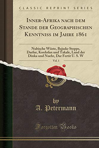
Paperback. Condition: New. Print on Demand. This book presents a detailed account of the author's 1860 journey through the Nubian Desert from Korosko to Berber. The author, a botanist, provides meticulous observations on the region's geography, vegetation, and wildlife, along with insights into the local culture and customs. Drawing upon scientific knowledge of the time, the book offers a valuable historical record of the natural and human environment of the Nubian Desert during the 19th century. Through detailed descriptions and analysis, the author sheds light on the challenges and rewards of scientific exploration in a remote and unforgiving landscape, showcasing the significance of preserving and understanding our natural heritage. This book is a reproduction of an important historical work, digitally reconstructed using state-of-the-art technology to preserve the original format. In rare cases, an imperfection in the original, such as a blemish or missing page, may be replicated in the book. print-on-demand item.
-

Grundlagen Der Astrophysik : Zweiter Teil II -Language: german
Seller: GreatBookPricesUK, Woodford Green, United Kingdom
Seller rating 5 out of 5 stars
Condition: New.
-

Inner-Afrika nach dem Stande der geographischen Kenntniss in den Jahren 1861 u. 1862. Nach den Quellen bearbeitet. Dritte Abtheilung: Originalbericht VI: Antinori's Reise zum Lande der Djur, 1860 u. 1861. Originalbericht VII: M. v. Beurmann's Aufenthalt in Mursuk und Reise nach Wau, 28. April bis 21. Juni 1862.
Published by Gotha: Perthes, 1862
Seller: Antiquariat Gallus / Dr. P. Adelsberger, Innsbruck, A, Austria
Seller rating 5 out of 5 stars
OBrosch. 4�, Tbl., pp. 79 - 96, mit 4 gro�formatigen gefalt Karten, 1) Mit der Originalkarte zu Beurmanns Reise von Bengasi nach Mursuk und Wau. 2) Tafel 5: Wadai und Bagirmi 3) Tafel 7: Bar-Banda 4) Tafel 9: Kongo - (= Erg�nzungsheft Nr. 10, zu Petermann's "Georgraphischen Mittheilungen") - Einwandfreier Erhaltungszustand.
-
1881 Original Map of a Route from Lado to Dara, after the Survey of R.W. Felkin & Revd. C. Wilson, M.A. Sept. to Dec. 1879, Compiled and Drawn by B. Hassenstein.
Language: German
Published by Justus Perthes, Gotha, 1881
Map
No Binding. Condition: Very Good. Bruno Hassenstein (illustrator). In German: Originalkarte Einer Reiseroute von Lado bis Dara, Nach der Itinerar-Aufnahme von R.W. Felkin & Revd. C. Wilson, M.A. Sept. bis Dec. 1879, Construirt und Gezeichnet von B. Hassenstein. From "Mittheilungen aus Justus Perthes' Geographischer Anstalt uber Wichtige Neue Erforschungen auf dem Gessammtgebiete der Geographie von Dr. A. Petermann, 1881." Roughly: "Communications from Justus Perthes' Geographical Institute Concerning Important New Studies in the Whole Field of Geography by Dr. Augustus Petermann, 1881." Condition notes: 8.4" wide X 22.0" high in 3 panels (folded twice in the same direction), several closed tears at folds, top left corner has long, narrow crease.
-
1881 Overview Map of New French Fortifications Complied from C. Vogel's Map of France in 4 Sheets. With an inset of the new Fortress at Paris.
Language: German
Published by Justus Perthes, Gotha, 1881
Map
No Binding. Condition: Very Good. Bruno Hassenstein (illustrator). In German: Ubersicht der Neuen Franzosischen Landesbefestigung Zusammengestellt auf C. Vogel's Karte Frankreich in 4 Bl. This map does not identify which of the four sheets it is. This sheet covers the area from Paris on the west to Strassburg on the east, and from Koln on the north to Chalon on the south. Geopolitical boundaries tinted in pastels, cities shown in pink, and fortifications shown as red dots. From "Mittheilungen aus Justus Perthes' Geographischer Anstalt uber Wichtige Neue Erforschungen auf dem Gessammtgebiete der Geographie von Dr. A. Petermann, 1881." Roughly: "Communications from Justus Perthes' Geographical Institute Concerning Important New Studies in the Whole Field of Geography by Dr. Augustus Petermann, 1881." Condition notes: 15.4" wide X 14.6" in 4 panels (folded once in each direction) high, mildly toned, mild page waviness.
-
1881 Map and Profile of the Depths and Temperatures of the Bearing Strait Measured by W.H. Dahll on U.S. Coastal Survey Schooner "Yukon" September 5, 1880. Also, another profile of the Eastern Cap and the Diomedes Islands
Language: German
Published by Justus Perthes, Gotha, 1881
Map
No Binding. Condition: Very Good. Bruno Hassenstein (illustrator). In German: Tiefen un See-Temperturen der Bering-Strasse Gemessen von W.H. Dahll im U.S.C. Srvey Schr. "Yukon" 5 Sept. 1880. For the inset: Ansicht des Ost-Caps und der Diomedes Inseln. Map and temperature profile tinted blue by 2-degree isotherms. Physical profile tinted peach and blue. From "Mittheilungen aus Justus Perthes' Geographischer Anstalt uber Wichtige Neue Erforschungen auf dem Gessammtgebiete der Geographie von Dr. A. Petermann, 1881." Roughly: "Communications from Justus Perthes' Geographical Institute Concerning Important New Studies in the Whole Field of Geography by Dr. Augustus Petermann, 1881." Condition notes: 10.8" wide X 8.5" high, mildly toned, mild page waviness, soft fold (not creased) down the middle.
-
1881 Map of the Argentine Territory of Pampa, of Rio Negro, etc. After the Survey of the Expeditionary Force against the Indians, Under General D.J.A. Roca.
Language: German
Published by Justus Perthes, Gotha, 1881
Map
No Binding. Condition: Very Good. Bruno Hassenstein (illustrator). In German: Die Argentinischen Territorien der Pampa, des Rio-Negro &c. Nach dem Aufnahmen der Expeditionscorps gegen Indianer, unter General D.J.A. Roca. Cream and brown base map with water bodies tinted blue, geopolitical boundaries tinted pink, and certain areas along rivers tinted green. From "Mittheilungen aus Justus Perthes' Geographischer Anstalt uber Wichtige Neue Erforschungen auf dem Gessammtgebiete der Geographie von Dr. A. Petermann, 1881." Roughly: "Communications from Justus Perthes' Geographical Institute Concerning Important New Studies in the Whole Field of Geography by Dr. Augustus Petermann, 1881." Condition notes: 10.8" wide X 8.5" high, mildly toned, slight page waviness.
-
1881 Map of the Waterways of France based on the Map of Navigable Rivers of France Issued by the Ministry of Public Work in 1878.Also 2 insets: Paris and Surroundings; Flanders.
Language: German
Published by Justus Perthes, Gotha, 1881
Map
No Binding. Condition: Very Good. Bruno Hassenstein (illustrator). In German: Die Wasserstrassen Frakreich's nachh der Carte de la Navigatiom Interieure de la France Heraugegeben von Ministerium der Offentlichen Arbeiten 1878. For insets: Paris und Umgegend; Flandern. Black and white base map with rivers marked in various colors. From "Mittheilungen aus Justus Perthes' Geographischer Anstalt uber Wichtige Neue Erforschungen auf dem Gessammtgebiete der Geographie von Dr. A. Petermann, 1881." Roughly: "Communications from Justus Perthes' Geographical Institute Concerning Important New Studies in the Whole Field of Geography by Dr. Augustus Petermann, 1881." Condition notes: 13.5" wide X 10.8" high in 2 panels (folded once), mildly toned, mild page waviness.
-
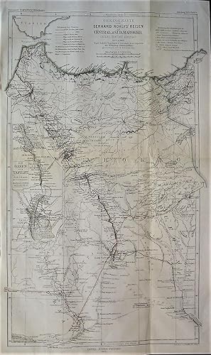
1865 Original Map of Gerhard Rohlfs' Travels in Central and South Morocco (Atlas, Talfilet, Draa, etc.) in 1862 and 1864. After Rohlfs' Journal and Personal Data and Other Sources. Drawn by B. Hassenstein. With an inset of the Tafilet Oasis.
Language: German
Published by Justus Perthes, Gotha, 1865
Map
No Binding. Condition: Very Good. Bruno Hassenstein (illustrator). In German: Originalkarte von Gerhard Rohlfs' Reisen Central und Sud Marokko (Atlas, Tafilet, Draa, &c.) 1862 und 1864. Nach Rohlfs' Tagebuch und personlichen Angaben mit Benutzung Anderer Quellen. Gezeichnet von B. Hassenstein. Generally in black and white, with routes in red and orange, and country borders tinted green. From "Mittheilungen aus Justus Perthes' Geographischer Anstalt uber Wichtige Neue Erforschungen auf dem Gessammtgebiete der Geographie von Dr. A. Petermann, 1865." Roughly: "Communications from Justus Perthes' Geographical Institute Concerning Important New Studies in the Whole Field of Geography by Dr. Augustus Petermann, 1865." Condition notes: 10.8" wide X 18.0" high in 4 panels (2 folds), modestly toned, mild page waviness, top left edge crinkled outside of the border.
-

Kindliche Sozialisation und Sozialentwicklung. ( = Fortschritte der Sozialp�diatrie, 2) .
Language: German
Published by Urban& Schwarzenberg M�nchen, 1978
ISBN 10: 3541066520 ISBN 13: 9783541066520
Hardcover/ Pappband. Condition: Gut. 194 Verhaltensbiologie Klinische Psychologie Verhaltenstherapie Kind Guter Zustand Mit Abb. ha1057590 Sprache: Deutsch Gewicht in Gramm: 350.
-

Grundlagen der Astrophysik : Zweiter Teil II
Language: German
Published by Springer Berlin Heidelberg, 1931
ISBN 10: 3642888526 ISBN 13: 9783642888526
Taschenbuch. Condition: Neu. Druck auf Anfrage Neuware - Printed after ordering - Dieser Buchtitel ist Teil des Digitalisierungsprojekts Springer Book Archives mit Publikationen, die seit den Anf�ngen des Verlags von 1842 erschienen sind. Der Verlag stellt mit diesem Archiv Quellen f�r die historische wie auch die disziplingeschichtliche Forschung zur Verf�gung, die jeweils im historischen Kontext betrachtet werden m�ssen. Dieser Titel erschien in der Zeit vor 1945 und wird daher in seiner zeittypischen politisch-ideologischen Ausrichtung vom Verlag nicht beworben.
-
Taschenbuch. Condition: Neu. Grundlagen der Astrophysik | Zweiter Teil II | W. Hassenstein (u. a.) | Taschenbuch | vii | Deutsch | Springer-Verlag GmbH | EAN 9783642888526 | Verantwortliche Person f�r die EU: Springer Verlag GmbH, Tiergartenstr. 17, 69121 Heidelberg, juergen[dot]hartmann[at]springer[dot]com | Anbieter: preigu.
-
1881 Map of Northwestern Mongolia Based on the Surveys and Recording of Local Conditions by Potainin and Rafailow 1876 & 1877.
Language: German
Published by Justus Perthes, Gotha, 1881
Map
No Binding. Condition: Very Good. Bruno Hassenstein (illustrator). In German: Karte der Nordwestlichen Mongolei nach den Aufnahmen und Ortsbestimmungen von Potanin und Rafailow 1876 & 1877. Cream and brown base map with water bodies tinted blue and travel routes in red. From "Mittheilungen aus Justus Perthes' Geographischer Anstalt uber Wichtige Neue Erforschungen auf dem Gessammtgebiete der Geographie von Dr. A. Petermann, 1881." Roughly: "Communications from Justus Perthes' Geographical Institute Concerning Important New Studies in the Whole Field of Geography by Dr. Augustus Petermann, 1881." Condition notes: 13.2" wide X 10.8" high in 2 panels (folded once), mildly toned, mild page waviness.
-
1880 Maps of the Deep Sea Temperatures of the European North Sea. Compiled by H. Mohn. With 8 maps of isotherms at various depths, from surface to sea floor.
Language: German
Published by Justus Perthes, Gotha, 1881
Map
No Binding. Condition: Very Good. Bruno Hassenstein (illustrator). In German: Die Tiefsee-Temperaturen des Europaischen Nordmeeres Zusammengestelt von H. Mohn. Land masses tinted peach, isotherms tinted pink and blue. From "Mittheilungen aus Justus Perthes' Geographischer Anstalt. Herausgegeben von Dr. E. Behm. Erganzungsband XIV, 1880-1881." Roughly: "Communications from Justus Perthes' Geographical Institute. Edited by Dr. E. Behm. Supplement 14, 1880-1881." Condition notes: 21.7" wide X 10.8" high in 3 panels (folded twice in one direction), mildly toned, mild page waviness.
-
1881 Geological Map of the Queen Charlotte Islands after George M. Dawson's surveys 1878.With an inset of Skidegate Inlet.
Language: German
Published by Justus Perthes, Gotha, 1881
Map
No Binding. Condition: Very Good. Bruno Hassenstein (illustrator). In German: Geologische Karte der Queen Charlotte Islands nach George M. Dawson's Aufnahmen 1878. Color map and inset of geologic types. Also shown are small black and white drawings of game pieces, a ceremonial spoon, fish hooks, a fishing club, a castanet made from Puffin beaks, and a rattle shaped like a raven as well as other figures. This is a beautiful and interesting map. From "Mittheilungen aus Justus Perthes' Geographischer Anstalt uber Wichtige Neue Erforschungen auf dem Gessammtgebiete der Geographie von Dr. A. Petermann, 1881." Roughly: "Communications from Justus Perthes' Geographical Institute Concerning Important New Studies in the Whole Field of Geography by Dr. Augustus Petermann, 1881." Condition notes: 8.4" wide X 10.8" high, mildly toned, mild page waviness, soft fold (not creased) down the middle, lt sm stain to bottom margin.
-
1881 Map of E. Marino's Survey of the Middle River El Abiad and of the River El Saraf September 1879 to March 1880. Based on the Original Recordings and Hand Drawn Sketches Constructed and Drawn by Christian Peip. Also 2 insets: Sketch of the Bar of the White Nile from December 7 to 15, 1880 as Surveyed by E. Marno; Sketch of the Proposed Canal at the mouth of the White Nile.
Language: German
Published by Justus Perthes, Gotha, 1881
Map
No Binding. Condition: Very Good. Bruno Hassenstein (illustrator). In German: E. Marino's Aufnahme des Mittleren Bahr El Abiad und des Bahr El Seraf Sept. 1879 bis Marz 1880. Nach dem Original-Tagebuch u. Handerschrift Skizzen Construirt & Autographirt von Chr. Peip. For insets: Kizze der barre im Bahr el Abiad v 7-15 Dec. 1880 durchbrochen von E. Marno; Skizze des Projectirten Kanal's Verlegung fer Mundung des Bahr el Gebel, Black and white base map, with some areas shaded blue. From "Mittheilungen aus Justus Perthes' Geographischer Anstalt uber Wichtige Neue Erforschungen auf dem Gessammtgebiete der Geographie von Dr. A. Petermann, 1881." Roughly: "Communications from Justus Perthes' Geographical Institute Concerning Important New Studies in the Whole Field of Geography by Dr. Augustus Petermann, 1881." Condition notes: 13.0" wide X 17.7" high in 4 panels (folded once in each direction), mildly toned, mild page waviness, crescent-shaped closed tear to left margin and map area.
-
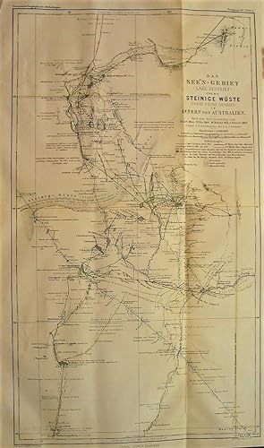
1867 Map of the Lake District and the Stony Desert of the Interior of Australia. According to the Travel Journals of Stuart 1845, Wills 1860, McKinlay 1861-1862, and Howitt 1862. Drawn by B. Hassenstein, edited by A. Petermann.
Language: German
Published by Justus Perthes, Gotha, 1867
Map
No Binding. Condition: Very Good. Bruno Hassenstein (illustrator). In German: Das See'n-Gebiet und die Steinice Wuste im Innern von Australien. Nach den Reisejournalen von Stuart 1845, Wills 1860, McKinlay 1861-1862, und Howitt 1862.) Constr. Von B. Hassenstein, dir. Von A. Petermann. Black and white base map with regional boundaries in pastels, and travel routes in color. From "Mittheilungen aus Justus Perthes' Geographischer Anstalt uber Wichtige Neue Erforschungen auf dem Gessammtgebiete der Geographie von Dr. A. Petermann, 1867." Roughly: "Communications from Justus Perthes' Geographical Institute Concerning Important New Studies in the Whole Field of Geography by Dr. Augustus Petermann, 1867." Condition notes: 10.9" wide X 18.0" high, in 4 panels (folded twice, once in each direction), modestly toned, mild page waviness, narrow crease to upper left margin.
-
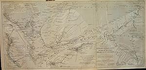
1865 Original Map from Gerhard Rohlfs' Journey to the Oases of Tuat and Tidikelt and the Northern Part of the Tuareg Region (North Africa). Designed after the Explorer's Survey and with the Use of the Maps of Duveyrier, Colonieu and Burin, de Colomb, et al. Drawn by Hassenstein. With two insets of the Tuat and Tidikelt oases groups.
Language: German
Published by Justus Perthes, Gotha, 1865
Map
No Binding. Condition: Very Good. Bruno Hassenstein (illustrator). In German: Originalkarte von Gerhard Rohlfs' Reise durch Die Oasen von Tuat und Tidikelt und den Nordlichen Theil des Tuareg-Gebietes (Nord-Afrika). Nach dem Tagebuch des Reisenden entworfen und mit Benutzung der Karten und Ekundigugen von Duveyrier, Colonieu und Burin, de Colomb U.A. Gezeichnet von Hassenstein. Generally in black and white, with routes in red. From "Mittheilungen aus Justus Perthes' Geographischer Anstalt uber Wichtige Neue Erforschungen auf dem Gessammtgebiete der Geographie von Dr. A. Petermann, 1865." Roughly: "Communications from Justus Perthes' Geographical Institute Concerning Important New Studies in the Whole Field of Geography by Dr. Augustus Petermann, 1865." Condition notes: 21.0" wide X 10.4" high, landscape orientation with 3 panels (2 folds), modestly toned, mild page waviness, crinkles to upper left margin outside of the border.

