Nat Geo Maps (Over 2,000 results)

Seller: Rarewaves.com USA, London, LONDO, United KingdomRarewaves.com USA
Contact seller5-star sellerCondition: New
£ 8.20
Free ShippingShips from United Kingdom to U.S.A.Quantity: 1 available
Map. Condition: New. . Waterproof . Tear-Resistant . Travel MapNational Geographic's City Destination map of Munich is an invaluable tool for exploring the capital of Bavaria. The comprehensive street map on the front side provides exceptional detail of the city. Points of interest, hotels, places of worship, notable buildings,…theaters, parks, information centers, and more are easy to find with the multi-language legend. Transportation aids such as subway and regional railway stations and parking areas are shown as well.Information on various points of interest are included on the reverse side, along with maps of the region and the extravagant palace of Schloss Nymphenburg. The Romantic Road and Bavarian Alps map provides detail of the Romantic, Alpine, Castle and Thuringia, and Alpine-Baltic roads. Handy diagrams of Munich (Franz Josef Strauss) International Airport and the U-Bahn (subway) and S-Bahn (suburban trains) transit systems will help you navigate the city quickly and efficiently.Every Destination Map is printed on durable synthetic paper, making them waterproof, tear-resistant and tough - capable of withstanding the rigors of any kind of travel.

Seller: Rarewaves USA, OSWEGO, IL, U.S.A.Rarewaves USA
Contact seller5-star sellerCondition: New
£ 8.49
Free ShippingShips within U.S.A.Quantity: 2 available
Map. Condition: New. . Waterproof . Tear-Resistant . Travel MapNational Geographic's City Destination map of Orlando is both a comprehensive map and travel guide for the city for business and leisure travelers alike. The city is presented using various maps with different levels of detail. A road map of the entire state of Flori…da shows the city's position in the center of the state and a regional map shows the roads leading in a out of the city. A city map of the Orlando area shows the city and its suburbs and inset maps of the Walt Disney Resort, International Drive and Downtown provide unparalleled detail of these popular areas. Pinpointed on the maps are hundreds of hotels, theaters, churches, parks, train stations, churches, notable buildings and points of interest.Each inset map is accompanied by an easy to use index of cities and towns, roads, hotels, attractions, golf courses, parks and other points of interest, which will aid in planning your route and arriving at your destination. A diagram of Orlando Airport will allow you to navigate this travel hub quickly and efficiently. Background information about the city, an overview of the public transit system and descriptions of top attractions in and around the city are also provided. Every Destination Map is printed on durable synthetic paper, making them waterproof, tear-resistant and tough - capable of withstanding the rigors of any kind of travel.

Seller: Rarewaves USA, OSWEGO, IL, U.S.A.Rarewaves USA
Contact seller5-star sellerCondition: New
£ 8.49
Free ShippingShips within U.S.A.Quantity: 3 available
Map. Condition: New. 2018th ed. . Waterproof . Tear-Resistant . Travel MapNational Geographic's City Destination map of Toronto was designed for business and leisure travelers alike. Canada's capital city is covered with unparalleled detail in a unique package that combines a easy to read street map and travel guide. A regional…map and an inset map of the city center, along with information about the city and its points of interest are featured on the front side of the map. A user friendly index of streets, hotels, public buildings, points of interest, metro stations, parks and beaches will help you find your destination quickly. While an overview of the transit system, a comprehensive metro map and map of Toronto Pearson International Airport will aid in your navigation around the city. A detailed street map of the city is shown on the reverse side, including the Toronto Islands. as well as an inset map of the Eastern Beaches. Points of interest, theaters, monuments, hotels, churches, parks, visitor information centers, notable buildings, underground walkways and pedestrian areas are clearly marked and easy to find with the multi-language legend. Many popular attractions are depicted in 3D, including the CN Tower, Ontario Parliament Buildings and Eaton Center. The location of train and metro stations, ferry routes and parking areas will further assist your exploration of the city. Every Destination Map is printed on durable synthetic paper, making them waterproof, tear-resistant and tough - capable of withstanding the rigors of any kind of travel.

Seller: Rarewaves USA, OSWEGO, IL, U.S.A.Rarewaves USA
Contact seller5-star sellerCondition: New
£ 8.49
Free ShippingShips within U.S.A.Quantity: 1 available
Map. Condition: New. 2025th ed. . Waterproof . Tear-Resistant . Travel MapDesigned for those who enjoy viewing the country on 2 or 4 wheels, National Geographic's Scenic Drives USA Guide Map covers 20 of the most beautiful scenic drives from coast to coast. Plan your trip using the national road map with clear designations for t…oll and toll-free roads, interstate highways, state routes and other primary highways along with pinpointed locations of the scenic drives and national parks. Each scenic drive has its own inset map showing the route from beginning to end, as well as points of interest along the way; road notes describing the drive; and a chart showing the estimated driving time and distance. Also included are the address, phone number and website for each state's tourism office.Every State Guide Map is printed on durable synthetic paper, making them waterproof, tear-resistant and tough - capable of withstanding the rigors of any kind of travel.

Seller: Better World Books, Mishawaka, IN, U.S.A.Better World Books
Contact seller5-star sellerCondition: Used - Good
£ 8.51
Free ShippingShips within U.S.A.Quantity: 1 available
Condition: Good. Pages intact with minimal writing/highlighting. The binding may be loose and creased. Dust jackets/supplements are not included. Stock photo provided. Product includes identifying sticker. Better World Books: Buy Books. Do Good.

Seller: Rarewaves USA, OSWEGO, IL, U.S.A.Rarewaves USA
Contact seller5-star sellerCondition: New
£ 8.91
Free ShippingShips within U.S.A.Quantity: 2 available
Map. Condition: New. . Waterproof . Tear-Resistant . Travel MapHome to some of the world's best known mega casinos-hotels, Las Vegas is internationally recognized by its unique cityscape along The Strip. Whether traveling to 'Sin City' for business or pleasure, National Geographic's City Destination map of Las Vegas will be an i…nvaluable travel companion, serving both as a comprehensive street map and well-researched travel guide. The map's front side features a regional map and inset maps of the downtown area and Grand Canyon, Bryce Canyon and Zion National Parks. An overview of the transit system along with a diagram of McCarran International Airport will help you get acclimated to the city. Information is also provided about popular attraction in and around the city. The main road map is on the reverse side, detailed with hundreds of points of interest, hotels, notable buildings, parks and theaters, as well as police stations, hospitals and post offices. Many top attractions are displayed in 3D, including the Stratosphere Tower, the Bellagio and MGM Grand. A user friendly index of streets and points of interest, will help you find your destination and plan your route quickly and efficiently. Every Destination Map is printed on durable synthetic paper, making them waterproof, tear-resistant and tough - capable of withstanding the rigors of any kind of travel.

Seller: Rarewaves USA, OSWEGO, IL, U.S.A.Rarewaves USA
Contact seller5-star sellerCondition: New
£ 8.92
Free ShippingShips within U.S.A.Quantity: 2 available
Map. Condition: New. . Waterproof . Tear-Resistant . Travel MapExplore the vibrant urban life, culture, and natural beauty of Sydney with National Geographic's City Destination map. A detailed street map and inset of Sydney Harbour is featured on the front side of this comprehensive map. Transportation decisions in and around th…e city are made easier with the inclusion of ferry stops and CityRail, light rail, monorail, and Sydney Explorer stations. Hundreds of points of interest, places of worship, parks, notable buildings, pedestrian areas, hotels, theaters, and more are noted. The reverse side of the map has both a regional map and a diagram of the Sydney Airport. Unlike many city maps, this one also acts as a travel guide with information about points of interest, sites to visit around Sydney, and the many public transportation options. The CityRail map will prove particularly helpful to visitors wishing to travel to most attractions in the city as well as surrounding suburbs.Every Destination Map is printed on durable synthetic paper, making them waterproof, tear-resistant and tough - capable of withstanding the rigors of any kind of travel.

Seller: Rarewaves USA, OSWEGO, IL, U.S.A.Rarewaves USA
Contact seller5-star sellerCondition: New
£ 9.29
Free ShippingShips within U.S.A.Quantity: 5 available
Map. Condition: New. 2024th ed. . Waterproof . Tear-Resistant . Travel MapNational Geographic's City Destination map of Madrid is both a comprehensive map and travel guide. Known for its nightlife and arts, the city has many attractions to explore virtually around the clock. A detailed street map of the city is featured on the f…ront side of the map. Points of interest, hotels, places of worship, notable buildings, theaters, parks, information centers, and more are easy to find with the multi-language legend. National and regional railway stations as well as Metro stations and other transportation aids will prove invaluable in traversing the city.Further detail of Central Madrid is included on the reverse side along with information on points of interest and a regional map. A diagram of Barajas Airport and a map of Metro stations will help you navigate these travel hubs quickly and efficiently.Every Destination Map is printed on durable synthetic paper, making them waterproof, tear-resistant and tough - capable of withstanding the rigors of any kind of travel.

Seller: Rarewaves USA, OSWEGO, IL, U.S.A.Rarewaves USA
Contact seller5-star sellerCondition: New
£ 9.70
Free ShippingShips within U.S.A.Quantity: 2 available
Map. Condition: New. . Waterproof . Tear-Resistant . Travel MapResting on the Nazca tectonic plate in the eastern Pacific Ocean approximately 600 miles west of Ecuador, the actively volcanic Galápagos Islands were discovered in 1535 by the bishop of Panama, Tomás de Berlanga, when his ship drifted off course. In 1835, naturalist… Charles Darwin, aboard the H.M.S Beagle, arrived in the Galápagos and spent 5 weeks collecting geological and biological specimens from several islands, noting his surprise at the variety of birds, tortoises, iguanas and other creatures-all without fear of humans. Darwin's short visit inspired, in part, his 1859 theory of evolution by natural selection and led to the declaration of Galápagos as a national park 100 years later in 1959. Galápagos was declared the first UNESCO World Heritage site in 1978.Now, National Geographic has created a map of this island chain that is so remote that many of the species who live here can be found nowhere else on earth. The front of the map includes an overview of the entire island chain to help with context since the islands are spread over a large swath of ocean. On the back of the map, each major island has a description including the endemic species (animals or plants living only on the Galápagos), facts about the human history of each island, and other facts that are important to travelers.Every Adventure Map is printed on durable synthetic paper, making them waterproof, tear-resistant and tough - capable of withstanding the rigors of international travel.

Seller: Rarewaves USA, OSWEGO, IL, U.S.A.Rarewaves USA
Contact seller5-star sellerCondition: New
£ 9.70
Free ShippingShips within U.S.A.Quantity: 4 available
Map. Condition: New. 2026th ed. . Waterproof . Tear-Resistant . Travel MapExpertly researched and loaded with helpful information, National Geographic's Texas Guide Map is a must-have for travelers exploring 'The Lone Star State.' In addition to a state map, inset maps provide detail on the Texas Panhandle and the cities of Dall…as, Fort Worth, Houston, Amarillo, Abilene, Lubbock, Waco, Laredo, Beaumont, El Paso, Odessa-Midland, McAllen, Corpus Christi, San Antonio, and Austin. Cities and towns are easy to find with the map's helpful index and hundreds of attractions are noted. Road network designations are clear and distances in miles on major highways are shown.Additional information and maps feature the recreation activities available in Big Bend National Park and the attractions along the Hill Country scenic drive. The Alamo, the Space Center Houston, the San Antonio Riverwalk, and Guadalupe Mountains National Park are just some of the many points of interest that are highlighted. A handy chart of park service sites and climate information are also included.Every State Guide Map is printed on durable synthetic paper, making them waterproof, tear-resistant and tough - capable of withstanding the rigors of any kind of travel.

Seller: Rarewaves USA, OSWEGO, IL, U.S.A.Rarewaves USA
Contact seller5-star sellerCondition: New
£ 9.73
Free ShippingShips within U.S.A.Quantity: 3 available
Map. Condition: New. 2026th ed. . Waterproof . Tear-Resistant . Travel MapCovering the country from Philadelphia to the Florida Keys and west to the Mississippi River, National Geographic's Southeastern USA Guide Map is designed to meet the needs of all travelers to this part of the country. The main map displays a comprehensive… interstate highway network, complete with mileage markers and designations for toll and free access roads, as well as smaller state highways and county roads. Points of interest, national parks and forests, airports and state capitals are pinpointed. An index of cities and towns will help you quickly locate your destination. More than 20 metropolitan areas can be found on inset maps, providing extra detail of each area's road network and points of interest. Inset maps are also provided for the Everglades, Shenandoah and Great Smoky Mountains National Parks. Traveling information is given about the Deep South, Coastal South, southern Appalachian Mountain and Chesapeake Bay areas, Florida and many national parks.Every State Guide Map is printed on durable synthetic paper, making them waterproof, tear-resistant and tough - capable of withstanding the rigors of any kind of travel.

Seller: Rarewaves USA, OSWEGO, IL, U.S.A.Rarewaves USA
Contact seller5-star sellerCondition: New
£ 9.73
Free ShippingShips within U.S.A.Quantity: 5 available
Map. Condition: New. 2026th ed. . Waterproof . Tear-Resistant . Travel MapLet National Geographic's City Destination map of Florence guide you as you explore this historic city that was the birthplace of the Renaissance and is still considered a world center for fashion, art and culture. Featured on the map's front side is a cle…arly marked road network complete with designations for through routes, main and secondary roads, one way streets and pedestrian zones. Along with a multi-language legend, hundreds of points of interest are pinpointed, including notable buildings, places of worship, hotels, theaters, parking areas, rail stations, parks, police stations and hospitals. Many of the city's top attractions are displayed with 3D images, including Santa Maria del Fiore, Palazzo Vecchio and Ponte Vecchio.The reverse side has a regional map, showing the city's location on the heart of Tuscany. An insert map of Centro Storico provides extra detail of the remarkable city center. A user-friendly index of streets, hotels and points of interest, will ensure you find your destination quickly. A travel guide gives background information about the city, its most popular destinations and an overview of the public transit system, including a diagram of Amerigo Vespucci airport. With such an abundance of specialized content that is not available in traditional maps, this destination map is the perfect complement to National Geographic's Florence and Tuscany Traveler Guide.Every Destination Map is printed on durable synthetic paper, making them waterproof, tear-resistant and tough - capable of withstanding the rigors of any kind of travel.

Seller: Upward Bound Books, VALRICO, FL, U.S.A.Upward Bound Books
Contact seller5-star sellerCondition: Used - Good
£ 6.51
£ 3.22 shippingShips within U.S.A.Quantity: 1 available
Condition: good. Gently used with light wear to the cover, corners, or spine. Pages are clean and free of writing or highlighting. Binding is tight and fully intact. Dust jacket included with hardcover books. Ships fast in a protective poly mailerâ"Monday through Friday, excluding weekends and holidays.

Seller: Rarewaves USA, OSWEGO, IL, U.S.A.Rarewaves USA
Contact seller5-star sellerCondition: New
£ 9.91
Free ShippingShips within U.S.A.Quantity: 5 available
Map. Condition: New. 2026th ed. . Waterproof . Tear-Resistant . Travel MapNational Geographic's City Destination map of Buenos Aires combines a city map and travel guide, making it the ultimate traveling companion to Argentina's capital city. Featured on the front side are a regional map and inset map of Isla Martin Garcia. Maps… of Ezeiza Airport and the subway (subte) along with an overview of the public transit system will help you travel around the city efficiently. Find your destination and plan your route using the user friendly index of streets, hotels, parks, metro stations, points of interest and public buildings. Information about the most popular points of interest in and around the city is also provided.The main street map of the city is on the reverse side. In addition to road network designations for through routes, main and secondary roads, and one ways streets, the map also pinpoints hundreds of points of interest, public transit stations, monuments, theaters, places of worship, hotels, notable buildings and parks, along with a multi-language legend. Inset maps show the Belgrano and La Boca neighborhoods. Every Destination Map is printed on durable synthetic paper, making them waterproof, tear-resistant and tough - capable of withstanding the rigors of any kind of travel.

Seller: Rarewaves USA, OSWEGO, IL, U.S.A.Rarewaves USA
Contact seller5-star sellerCondition: New
£ 9.92
Free ShippingShips within U.S.A.Quantity: 3 available
Map. Condition: New. 2026th ed. . Waterproof . Tear-Resistant . Travel MapWell know for its rich history and historic city center, Prague is one of the most visited cities in all of Europe. Expertly researched, National Geographic's City Destination map of Prague is a unique combination of an easy-to-read road map with a travel…guide. The front side covers the five quarters of the city center with unparalleled detail. Road designations are shown and hundreds of points of interest are pinpointed, including subway, train and tram stations, theaters, hotels, places of worship, notable buildings and parks. Many of the city's top attractions are depicted in 3D, including the Prague Castle, Charles Bridge and National Museum.The reverse side has a regional map as well as inset maps of the Castle District and Charles Bridge. Finding your destination couldn't be simpler, with streets names, parks, hotels, metro stations and points of interest listed in a convenient index. A comprehensive map of the city's three metro lines will aid in your navigation around the city, as will a diagram of Prague airport and an overview of the city's public transportation. Also included is essential information about the city and descriptions of many of the most popular attractions. Such an abundance of specialized information make this map the perfect complement to National Geographic's Prague Traveler Guide.Every Destination Map is printed on durable synthetic paper, making them waterproof, tear-resistant and tough - capable of withstanding the rigors of any kind of travel.

Seller: Rarewaves USA, OSWEGO, IL, U.S.A.Rarewaves USA
Contact seller5-star sellerCondition: New
£ 10.82
Free ShippingShips within U.S.A.Quantity: 2 available
Map. Condition: New. . Waterproof . Tear-Resistant . Travel MapBusiness and leisure travelers alike will find National Geographic's City Destination map of Los Angeles is an invaluable tool for exploring this diverse global city. A unique combination of city map and travel guide, this is the ultimate travel companion.The front s…ide includes inset maps of Westside, Long Beach and Anaheim along with a regional map and diagrams of Los Angeles (LAX) and John Wayne Airports. Provided also are general information about the city and surrounding areas, descriptions of popular points of interest and an overview of public transit system. The reverse side features the main map of the entire city from the Santa Monica Mountains to Chino Hills along with an inset map of the downtown area. The easy to read street map shows road designations for freeways, toll roads, main streets, secondary roads and one way streets. Pinpointed are hundreds of points of interest, including subway and train stations, hotels, theaters, churches, notable buildings and parks. A user friendly index of cities and towns, neighborhoods, roads and streets, hotels and points of interest will help you find your destination and plan your route quickly and efficiently.Every Destination Map is printed on durable synthetic paper, making them waterproof, tear-resistant and tough - capable of withstanding the rigors of any kind of travel.

Seller: Rarewaves USA, OSWEGO, IL, U.S.A.Rarewaves USA
Contact seller5-star sellerCondition: New
£ 10.82
Free ShippingShips within U.S.A.Quantity: 7 available
Map. Condition: New. . Waterproof . Tear-Resistant . Travel MapBusiness and leisure travelers alike will marvel at National Geographic's City Destination map of New York City. Expertly researched, it contains a comprehensive road map and an informative travel guide, making it the ideal travel companion as well as the perfect com…plement to National Geographic's New York Traveler Guide. The easy-to-read street map covers Manhattan from Uptown to the Financial District and includes the many bridges and tunnels that cross the Hudson and East Rivers. Pinpointed are hundreds of points of interest, including hotels, theaters, notable buildings, churches, synagogues, parks, police stations, hospitals and subway stations with 3D depictions for many top attractions, like the Empire State Building and Metropolitan Museum of Art .Insert maps of Midtown and Lower Manhattan provide extra detail of these heavily traveled areas. An additional regional insert map shows all five boroughs of New York City and parts of New Jersey. A complete subway map, diagrams of LaGuardia, JFK and Newark Airports, ferry routes and a user friendly index streets, tunnels and bridges; neighborhoods, districts and boroughs; parks; theaters; and other points of interest, will help you plan your route and find your destination quickly. Descriptions of the city, popular attractions and the transit system provide valuable information for visitors.Every Destination Map is printed on durable synthetic paper, making them waterproof, tear-resistant and tough - capable of withstanding the rigors of any kind of travel.

Seller: Rarewaves USA, OSWEGO, IL, U.S.A.Rarewaves USA
Contact seller5-star sellerCondition: New
£ 10.82
Free ShippingShips within U.S.A.Quantity: 2 available
Map. Condition: New. 2026th ed. . Waterproof . Tear-Resistant . Travel MapOne of the most visited places in the world for the past two millennia, Rome has been an important city for Western Civilization as well for Christianity. Let National Geographic's City Destination map of Rome, lead you on your exploration of this fascinat…ing ancient destination. Combining an easy-to-read road map along with a travel guide, this expertly researched map is unparalleled in its accuracy and content making it the ideal travel companion as well as the perfect complement to National Geographic's Rome Traveler Guide. The front side has a regional map and descriptions of the city, many popular attractions and the transit system. A user-friendly index of streets, hotels and points of interest along with a metro (or Metropolitana) map and a diagram of Fiumicino Airport will help you arrive at your destination quickly. An inset map of Vatican City provides details of this very popular area. The road map on the reverse side labels main, secondary and one-way streets with a multi-language legend. In addition, hundreds are popular and lesser known points of interest are pinpointed, including metro stations, places of worship, theaters, hotels, hospitals, police stations and notable buildings.Every Destination Map is printed on durable synthetic paper, making them waterproof, tear-resistant and tough - capable of withstanding the rigors of any kind of travel.

Seller: Rarewaves.com USA, London, LONDO, United KingdomRarewaves.com USA
Contact seller5-star sellerCondition: New
£ 11.00
Free ShippingShips from United Kingdom to U.S.A.Quantity: 1 available
Map. Condition: New. 2020th ed. . Waterproof . Tear-Resistant . Topographic MapOutdoor enthusiasts seeking recreational opportunities in central Arizona, will find National Geographic's Trails Illustrated map of Mogollon Rim and Munds Mountain an essential travel companion. Expertly researched and created in cooperation with the… U.S. Forest Service and others, the map covers parts of the Tonto, Coconino and Apache-Sitgreaves National Forests and provides unmatched detail of the region, including popular places of interest, such as Munds Mountain, Wet Beaver, West Clear Creek, Fossil Springs and Mazatzal Wilderness Areas, Verde Wild and Scenic River, Montezuma Castle National Monument, Red Rock Scenic Byway and Mogollon Plateau.Get off the beaten path and back on again by following the map to clearly marked trailheads and trails, labeled according to their designated usage. The Highline, General Crook and Arizona Trails are all highlighted. Your navigation of the area will be aided by the map's contour lines, elevations, labeled peaks and summits, water features, numbered Forest Service roads and selected waypoints. Recreation features pinpointed on the map include: campgrounds, swimming areas, boat launch and river access points, interpretive trails and scenic viewpoints. The map also provides background information of the area including the wilderness areas, safety tips and essential contact information.Every Trails Illustrated map is printed on 'Backcountry Tough' waterproof, tear-resistant paper. A full UTM grid is printed on the map to aid with GPS navigation.Other features found on this map include: Coconino National Forest, Fossil Springs Wilderness, Horse Mesa, Mazatzal Wilderness, Munds Mountain Wilderness, Pine Mountain Wilderness, Prescott National Forest, Sedona, Sitgreaves National Forest, Tonto National Forest, West Clear Creek Wilderness.

Seller: Rarewaves USA, OSWEGO, IL, U.S.A.Rarewaves USA
Contact seller5-star sellerCondition: New
£ 11.06
Free ShippingShips within U.S.A.Quantity: 2 available
Map. Condition: New. 2022nd ed. . Waterproof . Tear-Resistant . Topographic MapNational Geographic's Trails Illustrated map of Yellowstone National Park is designed to meet the needs of outdoor enthusiasts by combining valuable information with unmatched detail of America's first national park. Expertly researched and created in… partnership with local land management agencies, this map features key points of interest including Mammoth Hot Springs, Canyon Village, Yellowstone Lake, Yellowstone Falls, Grant Village, and Old Faithful geyser area.With over 1,000 miles of mapped trails, the Yellowstone National Park map can guide you off the beaten path and back again. The clearly marked trails include mileages between intersections. Trail summaries provide elevation, duration, and difficulty for a variety of suggested hikes. The map base includes contour lines and elevations for summits, passes and many lakes. The bathymetry of Yellowstone Lake is shown with both contours and hill shading. Some of the many recreation features include: campgrounds, trailheads, boat ramps, marinas, scenic overlooks and interpretive trails.Every Trails Illustrated map is printed on 'Backcountry Tough' waterproof, tear-resistant paper. A full UTM grid is printed on the map to aid with GPS navigation.Other features found on this map include: Absaroka-Beartooth Wilderness, Beartooth Mountains, Big Game Ridge, Buffalo Plateau, Colter Peak, Craig Pass, Crowfoot Ridge, Custer National Forest, Eagle Peak, Emigrant Peak, Gallatin National Forest, Grand Teton National Park, Granite Peak, Granite Range, Grouse Mountain, Heart Lake, Hurricane Mesa, Jedediah Smith Wilderness, John D. Rockefeller, Jr. Memorial Parkway, Lake Plateau, Lamar River, Lee Metcalf Wilderness, Lewis Lake, Lower Falls of the Yellowstone River, Mount Hancock, Mount Holmes, Mount Sheridan, Mount Wallace, Mount Washburn, North Absaroka Wilderness, Pilot Peak, Pitchstone Plateau, Ramshorn Peak, Red Mountains, Saddle Mountain, Shoshone Lake, Shoshone National Forest, Targhee National Forest, Teton National Forest, Teton Wilderness, Thorofare Plateau, Washakie Wilderness, Yellowstone Lake, Yellowstone National Park.

Seller: Rarewaves USA, OSWEGO, IL, U.S.A.Rarewaves USA
Contact seller5-star sellerCondition: New
£ 11.13
Free ShippingShips within U.S.A.Quantity: Over 20 available
Map. Condition: New. . Waterproof . Tear-Resistant . Travel MapNational Geographic's Canada West Adventure Map provides global travelers with the perfect combination of detail and perspective in a highly functional travel tool. Cities and towns are clearly indicated and easy to find in the user-friendly index. A road network com…plete with distances and designations for roads, motorways, and expressways will help you find the route that's right for you. Secondary routes are also marked for those seeking to explore off the beaten path in and around Banff National Park, the Yukon Territories, Jasper National Park, Vancouver Island, and the rainforests of British Columbia. Hundreds of points of interest and diverse and unique destinations are highlighted including national parks, nature reserves, World Heritage sites, archeological sites, ski areas, hot springs, beaches, museums, and more. The north side of the print map shows Victoria Island, Nanavut, the Great Slave Lake, the Northwest Territories, Yukon Plateau, Great Bear Lake and Prince Albert Sound. The reverse side showcases the topographic features of Vancouver and Queen Charlotte Islands, the Coast Mountains, British Columbia, the Rocky Mountains, and Alberta. Search for whales off the coast of Vancouver, ski the trails of Whistler, paddle the epic South Nahanni River as it tumbles through the jagged Mackenzie Mountains and the Nahanni National Park Reserve, a World Heritage-listed site. Whatever your adventure, this map is the perfect companion to a guidebook, yet far easier to pack.Every Adventure Map is printed on durable synthetic paper, making them waterproof, tear-resistant and tough - capable of withstanding the rigors of international travel.

Seller: Rarewaves USA, OSWEGO, IL, U.S.A.Rarewaves USA
Contact seller5-star sellerCondition: New
£ 11.38
Free ShippingShips within U.S.A.Quantity: 4 available
Map. Condition: New. . Waterproof . Tear-Resistant . Travel MapLet National Geographic's Iceland Adventure Map guide you as you discover the pristine nature and unique scenery on this Nordic island. The expertly researched map, with its accurate and detailed information, is designed to meet the needs of adventure travelers. In a…ddition to a clearly marked road network, with distances and destinations of both major and main roads, the map also delivers an abundance of specialized content not found in traditional road maps. An index of cities and towns will help you arrive at your destination quickly. Recreational, ecological, cultural, and historic points of interest as well as secondary roads, remote tracks, secluded paths and ferry routes will aid in your exploration both on and off the beaten path. Among the pinpointed points of interest are hot springs, geysers, waterfalls, caves, museums, lighthouses, swimming pools, golf courses, campsites and scenic viewpoints. Also labeled are the UNESCO World Heritage Sites, Thingvellir National Park and the volcanic island of Surtsey. The shaded relief map details the entire island, contour lines are drawn, peaks and summits are labeled with elevations, forested areas are shaded, water features are shown and boundaries of National Parks and nature reserves are color-coded, making it the perfect companion to any guidebook. Every Adventure Map is printed on durable synthetic paper, making them waterproof, tear-resistant and tough - capable of withstanding the rigors of international travel.

Seller: Rarewaves USA, OSWEGO, IL, U.S.A.Rarewaves USA
Contact seller5-star sellerCondition: New
£ 11.42
Free ShippingShips within U.S.A.Quantity: 18 available
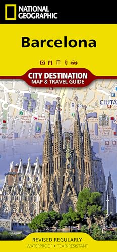
Map. Condition: New. . Waterproof . Tear-Resistant . Travel MapNational Geographic's City Destination map of Barcelona combines a city map and travel guide, making it the ultimate traveling companion to this popular destination on Spain's Mediterranean coast. The easy-to-read road map covers the city from the Les Corts and Sants…-Montjuic districts in the south and west to Sant Marti in the northeast. Included are hundreds of points of interest, such as metro and railway stations, places of worship, notable buildings, parks, police stations and hospitals, along with 3D depictions of many top attractions. The front side has a regional map and descriptions of the city, many popular points of interest and the transit system. A user-friendly index of streets, hotels, train stations and points of interest along with a diagram of Barcelona Airport and a comprehensive metro map will help you plan your route and arrive at your destination quickly. An inset map of Ciutat Vella district provides detail of this very popular area which is the oldest part of the city. With all of this specialized content, this map is the perfect complement to National Geographic's Barcelona Traveler Guide. Every Destination Map is printed on durable synthetic paper, making them waterproof, tear-resistant and tough - capable of withstanding the rigors of any kind of travel.
Seller: Grand Eagle Retail, Bensenville, IL, U.S.A.Grand Eagle Retail
Contact seller5-star sellerCondition: New
£ 11.44
Free ShippingShips within U.S.A.Quantity: 1 available
Folded. Condition: new. Folded. In addition to the easy-to-read map on the front, the back includes: Regional map - Inset map of Ciutat Vella - Points of interest - Airport diagram - Metro map - Information on transportation, tipping, museums, and more - Multi-language legend National Geographic's City Destination map of Barcelo…na combines a city map and travel guide, making it the ultimate traveling companion to this popular destination on Spain's Mediterranean coast. Shipping may be from multiple locations in the US or from the UK, depending on stock availability.

Seller: Rarewaves USA, OSWEGO, IL, U.S.A.Rarewaves USA
Contact seller5-star sellerCondition: New
£ 11.51
Free ShippingShips within U.S.A.Quantity: 20 available
Map. Condition: New. 2025th ed. . Waterproof . Tear-Resistant . Topographic MapThe Wonderland Trail encircles Mount Rainier and was completed in 1915 by volunteers and designated a National Recreation Trail in 1981. The Wonderland Trail is known for its undulating terrain with a striking cumulative 22,000 feet of elevation gains… and losses. The Topographic Map Guide is arranged for clockwise travel around the Wonderland Trail starting at the Sunrise trailhead. Each map page has a detailed trail profile that shows the elevation changes you will encounter. Also, the Wonderland Trail is highlighted and centered on each page so you can easily track your progress. The Topographic Map Guide also includes information about Mt Rainier National Park as well as wilderness regulations and other important facts and tips to help make your journey on this amazing trail both successful and memorable.More convenient and easier to use than folded maps, but just as compact and lightweight, National Geographic's Topographic Map Guide booklets are printed on 'Backcountry Tough' waterproof, tear-resistant paper with stainless steel staples. A full UTM grid is printed on the map to aid with GPS navigation.

Seller: Rarewaves USA, OSWEGO, IL, U.S.A.Rarewaves USA
Contact seller5-star sellerCondition: New
£ 11.51
Free ShippingShips within U.S.A.Quantity: 4 available
Map. Condition: New. 2024th ed. Waterproof Tear-Resistant Stargazer Map and Guide. Every culture has drawn pictures in the stars, creating constellations that represent animals or mythic figures. Ancient astronomers peered into the night sky and imagined glittering jewels set in a crystal sphere slowly revolving around the Earth… from east to west. The 88 constellations recognized today by the International Astronomical Union (IAU) are not just pictures but basic units that partition the sky. The Night Sky - Northern Hemisphere Stargazer Map and Guide is centered on Polaris, the North Star, which appears fixed in place with the other stars on the chart rotating around it. Thus it has long aided navigators in determining both direction and latitude. The constellations and brighter stars are labeled with their latin names. The map includes a table of star magnitude or brightness. As the Earth moves in its orbit around the Sun the constellations in the sky change. The Night Sky map includes four seasonal charts that are specific for each season: spring, summer, autumn, and winter. Every Stargazer Map is printed on durable synthetic paper, making them waterproof, tear-resistant and tough - capable of withstanding the rigors of repeated outdoor use.

Seller: Rarewaves USA, OSWEGO, IL, U.S.A.Rarewaves USA
Contact seller5-star sellerCondition: New
£ 11.51
Free ShippingShips within U.S.A.Quantity: 1 available
Map. Condition: New. 2022nd ed. . Waterproof . Tear-Resistant . Topographic MapFirst protected in 1864 and designated as the third national park in 1890, Yosemite is home to countless natural icons including Yosemite Falls, the world's fifth tallest waterfall; El Capitan, one of the largest exposed monoliths of granite in the wo…rld; and Yosemite Valley and the Mariposa Grove of Giant Sequoias, which were the first scenic natural areas set aside by a national government for public benefit and appreciation. With so many spectacular historical, scientific and scenic resources and recreational opportunities that include backpacking, hiking, world-class climbing, fishing, camping and numerous winter pursuits, Yosemite has something for everyone.The Yosemite National Park Day Hikes Topographic Map Guide includes eighteen diverse hikes for all hiking enthusiasts, from the easy, 2.8 mile long Hetch Hetchy Valley Overlook to the strenuous, 14.7 mile long Laurel Lake Trail with 3,900' of elevation gain. Each hike has a detailed map, a trail profile visualizing the changes in elevation, and a short summary of the interesting features encountered along the trip.Some of the must-visit sites in this Topographic Map Guide are: Yosemite Falls-the tallest waterfall in North America at 2,425 feet, Mariposa Grove-a scenic loop featuring Giant Sequoias, some the biggest trees in the world, and Mono Pass-a historic trans-Sierra route used by Native Americans and settlers prior to the development of wagon roads.More convenient and easier to use than folded maps, but just as compact and lightweight, National Geographic's Topographic Map Guide booklets are printed on 'Backcountry Tough' waterproof, tear-resistant paper with stainless steel staples. A full UTM grid is printed on the map to aid with GPS navigation.

Seller: Rarewaves USA, OSWEGO, IL, U.S.A.Rarewaves USA
Contact seller5-star sellerCondition: New
£ 11.51
Free ShippingShips within U.S.A.Quantity: 3 available
Map. Condition: New. 2025th Revised ed. . Waterproof . Tear-Resistant . Topographic MapNational Geographic's Trails Illustrated map of Saguaro National Park and surrounding areas to the east and west of Tucson, is the perfect map for hiking, biking, exploring, climbing, riding, camping, and sightseeing in this beautiful desert w…ilderness. Created in partnership with local land management agencies, this expertly researched map highlights key areas of interest including Tucson Mountain Park, Sweetwater Preserve, Robles Pass, Saguaro Wilderness, Tanque Verde Ridge, and Hope Camp, Yetman, and Petroglyphs trails. This map features detailed topography with shaded relief, elevations, and clearly defined, color-coded boundaries for parks, public lands, and wilderness areas. With miles of mapped trails including a portion of the Arizona Trail, this map can guide you off the beaten path and back again in some of the most iconic scenery in the desert southwest. The clearly marked trails include mileage between intersections and handy hiking and trailhead summaries will help you choose the path that's right for you. Recreation features are clearly marked, including campgrounds, interpretive trails, rifle and archery ranges, scenic drives, picnic areas, and points of interest.Every Trails Illustrated map is printed on 'Backcountry Tough' waterproof, tear-resistant paper. A full UTM grid is printed on the map to aid with GPS navigation.Other features found on this map include: Coronado National Forest, Rincon Mountain Wilderness, Rincon Mountains, Saguaro National Park, Spud Rock, Tucson Mountains.

Seller: Rarewaves USA, OSWEGO, IL, U.S.A.Rarewaves USA
Contact seller5-star sellerCondition: New
£ 11.51
Free ShippingShips within U.S.A.Quantity: 2 available
Map. Condition: New. . Waterproof . Tear-Resistant . Travel MapLocated in Northwestern Mexico, the Baja California Peninsula is a popular travel destination for its abundant recreation and conservation opportunities. National Geographic's Baja North Adventure Map covers with unparalleled detail the state of Baja California and p…art of the UNESCO World Heritage Site, Islands and Protected Areas of the Gulf of California. The northern side of the map covers the US/Mexico border from Tijuana to Mexicali, including border crossings, as well as Ensenada. Inset maps give extensive detail to these three towns. The southern side shows Valle de los Cirios, Bahia de los Angeles and the World Heritage listed Rock Paintings of the Sierra de San Francisco and Whale Sanctuary of El Vizcaino. Cultural, historical, recreational and ecological points of interest, a road network and topographic features are all combined on this easy to use and expertly researched map. With such specialized content, this map is the perfect compliment to any guidebook. Pinpointed are missions, ruins, museums, lighthouses, scenic viewpoints, wildlife viewing spots, beaches and areas for surfing, diving, fishing, kayaking, sailing, windsurfing, snorkeling and whale watching. The detailed road network includes not only major highways and toll roads but also gravel and dirt roads, to help you get off the beaten path. Moreover, a table of distances is provided as are ferry routes, railroads and an index of protected areas and select towns.Every Adventure Map is printed on durable synthetic paper, making them waterproof, tear-resistant and tough - capable of withstanding the rigors of international travel.

Seller: Rarewaves USA, OSWEGO, IL, U.S.A.Rarewaves USA
Contact seller5-star sellerCondition: New
£ 11.51
Free ShippingShips within U.S.A.Quantity: 3 available
Map. Condition: New. . Waterproof . Tear-Resistant . Travel MapNational Geographic's Pyrenees and Andorra Adventure Map provides global travelers with the perfect combination of detail and perspective in a highly functional travel tool. This map includes the locations of cities and towns with a user-friendly index, plus a clearl…y marked road network complete with distances and designations for roads and highways. Beaches and yachting harbors dot Spain and France's Mediterranean coastlines while the location of golf courses, camping sites, waterfalls, caves, and ski areas make it easy to enjoy the region's abundant outdoor activities. National parks, World Heritage sites, scenic viewpoints, antiquity sites, museums, and more are included, making it invaluable to travelers hoping to experience all the history, art, and culture the region has to offer.The front side of the print map shows the country of Andorra and the eastern half of the Pyrenees including the cities of Narbonne, Carcassone, Pamiers, St-Gaudens, St-Girons, Perpignan in France, and Balaguer, Manresa, and Figueres in Spain. The reverse side of the map stretches from the city of Biarritz on the Bay of Biscay eastward to include Pamplona and Huesca, Spain, and Pau, Tarbes, and the famed pilgrimage site of Lourdes, France. Popular for alpine skiing and mountaineering, the Pyrenees are a scenic mountain range which form a natural boundary between Spain and France. Stages of two of cycling's epic grand tours - the Tour de France and the Vuelta a España - traverse the Pyrenees and three long-distance footpaths run the length of the mountain range. Nestled in the center of the Pyrenees is the ruggedly beautiful Andorra, the sixth smallest country in Europe which is roughly two and a half times the size of Washington, D.C. Its picturesque mountain vistas and easy charm have made Andorra a favorite destination for savvy travelers. Every Adventure Map is printed on durable synthetic paper, making them waterproof, tear-resistant and tough - capable of withstanding the rigors of international travel.


