
Order Total (1 Item Items):
Shipping Destination:

Japanese Map (73 results)
Skip to main search results
Search filters
Product Type
- All Product Types
- Books (24)
- Magazines & Periodicals (No further results match this refinement)
- Comics (No further results match this refinement)
- Sheet Music (No further results match this refinement)
- Art, Prints & Posters (No further results match this refinement)
- Photographs (No further results match this refinement)
- Maps (49)
- Manuscripts & Paper Collectibles (No further results match this refinement)
Condition Learn more
- New (No further results match this refinement)
- As New, Fine or Near Fine (2)
- Very Good or Good (No further results match this refinement)
- Fair or Poor (No further results match this refinement)
- As Described (71)
Binding
Collectible Attributes
- First Edition (2)
- Signed (7)
- Dust Jacket (No further results match this refinement)
- Seller-Supplied Images (71)
- Not Print on Demand (73)
Language (1)
Free Shipping
- Free Shipping to U.S.A. (No further results match this refinement)
Seller Location
Seller Rating
-

Condition: Fine. Number of books: 5.
-
Condition: Fine. Number of books: 1 book.
-
Der Russisch-Japanische Kriegsschauplatz. Japan, Korea, Ost-China und die Mandschurei.
Published by Verlag des Bibliographischen Instituts., Leipzig und Wien, 1904
Seller: Asia Bookroom ANZAAB/ILAB, Canberra, ACT, Australia
Association Member: ANZAAB ILAB
Seller rating 5 out of 5 stars

Colour folding map 88 x 60cm folding to 26 x 16cm, in original printed wrappers, inner hinge neatly re-enforced with archival washi otherwise a near fine copy Map showing the Russo-Japanese theatre of war, with inset maps of Port Arthur and the Liao-Tung Peninsula. .nebst gr�sseren Spezialdarstellungen des Gelben Meeres mit Golf von Tschili, des Russischen Gebiets auf der Halbinsel Liau-tung sowie Pl�nen von Port Arthur, Tokio und Yokohama. Scarce.
-
![Seller image for ???????. [Saishin sekai daichizu]. [The Current Large Map of the World]. for sale by Asia Bookroom ANZAAB/ILAB](https://pictures.abebooks.com/inventory/md/md32082031014.jpg)
???????. [Saishin sekai daichizu]. [The Current Large Map of the World].
Published by ?????????. [Dainihon Y?benkai K?dansha]. Showa 6 [1931]., ??. [Tokyo]., 1931
Seller: Asia Bookroom ANZAAB/ILAB, Canberra, ACT, Australia
Association Member: ANZAAB ILAB
Seller rating 5 out of 5 stars
Large colour folding map of the world with attractive border of some curiously chosen merchant ensigns and coats of arms along the upper and lower margins, 78 x 110 cm. Neat repairs along some folds on reverse, a little toning on map but still a good attractive copy. This large map of the world was issued as the new year supplement for a boys' magazine, Shonen Kurabu ????? in January 1931. Japan and its territories in red are positioned in the centre of the map. The vastness of Russia and the British Empire stand out and the Irish Free State is still indicated as being part of the UK. Interestingly, Russia is still shown in its customary Imperial green, rather than the more common red that was typically adopted for the Soviet Union.
-
![Seller image for ???????: 17 ?????????. [Hyo?jun Dai to?a bunzu: 17 Nyuujiirandohen]. Standard Maps of Greater East Asia: 17 New Zealand]. for sale by Asia Bookroom ANZAAB/ILAB](https://pictures.abebooks.com/inventory/md/md22530730031.jpg)
???????: 17 ?????????. [Hyo?jun Dai to?a bunzu: 17 Nyuujiirandohen]. Standard Maps of Greater East Asia: 17 New Zealand].
Published by ???(Tosei-sha) ??18 [Showa]1943., Tokyo, 1943
Seller: Asia Bookroom ANZAAB/ILAB, Canberra, ACT, Australia
Association Member: ANZAAB ILAB
Seller rating 5 out of 5 stars
Folding colour map of New Zealand with inset of Auckland and Wellington top and bottom corners,1:2,000,000 scale, little light browning. Original envelope worn with closed tears. 54 x 76.5cm. Good copy. Scale plan of New Zealand printed by Tosei in 1943. The map legend shows infrastructure deemed important to the Land Survey Bureau of the General Staff Headquaters of the Imperial Japanese army, such as boundaries, powerlines, quarries and mines; railroads, sea-routes, etc.
-
???????: 13 ????????????. [Hyo?jun Dai to?a bunzu: 13 Serebesu?Morukka shotou-hen]. [Standard Maps of Greater East Asia: 13 - Celebes and the Moluccas].
Published by ???(Tosei-sha) ?? [Showa] 18. [1943]., Tokyo (??), 1943
Seller: Asia Bookroom ANZAAB/ILAB, Canberra, ACT, Australia
Association Member: ANZAAB ILAB
Seller rating 5 out of 5 stars
Colour folding map, 54 x 75.5cm, with original envelope. Envelope a little torn, some occasional browning, very good. The 13th map in this Standard Maps of Greater East Asia series (of 20 maps). All text in Japanese. Shows railways, shipping routes, administrative boundaries, airfields, ports, lighthouses, mines, oil wells etc.
-

???????????????? Hyo?jun Daito?a bunzu daito?a bunzu: ?sutorariyahen. Standard Maps of Greater East Asia: Complete Map of Australia.
Published by To?seisha. Showa 18 [1943], Tokyo., 1943
Seller: Asia Bookroom ANZAAB/ILAB, Canberra, ACT, Australia
Association Member: ANZAAB ILAB
Seller rating 5 out of 5 stars
Folding colour map of Australia, 54.2 x 76.4cm. Some foxing particularly along folds and upper right margins a few repaired tears and small holes at folds.With original sleeve. The 15th map in the Standard Maps of Greater East Asia series (of 20 maps). Shows the natural resources such as sheep, gold, pearl, diary regions, opals etc. Tasmania appears as an inset in the bottom right corner. Text in Japanese.
-
![Seller image for ?????????. [Sekai senka no sekai zenzu]. [Map of the World under the World War]. for sale by Asia Bookroom ANZAAB/ILAB](https://pictures.abebooks.com/inventory/md/md31648309091.jpg)
?????????. [Sekai senka no sekai zenzu]. [Map of the World under the World War].
Published by ???. [Seibunkan]. Circa1942., ??. [Tokyo]., 1942
Seller: Asia Bookroom ANZAAB/ILAB, Canberra, ACT, Australia
Association Member: ANZAAB ILAB
Seller rating 5 out of 5 stars
Colour map, 75 x 110cm, folds to 28 x 19cm. Some light browning, somewhat heavier along a few folds. A good copy. This map, which was most likely published around 1942 or 1943, depicts the world during the global conflict. Japan is positioned in the centre, and its territories are coloured in red. In Southeast Asia, Japanese-occupied areas, including Singapore, the Philippines, and the Dutch East Indies, are marked with red. Two inset maps display Europe and the Japanese-occupied area to the south as the "Southern Co-Prosperity Sphere." The map is folded to 28 x 19 cm, and its cover features the national flags of Japan, Nazi Germany, Italy, the Soviet Union, Britain, and the United States, arranged artistically.
-
![Seller image for ????. ??????????????. ??. [Gunji himitsu Kitashina gomanbun no ichi zu Josh? 64-g?]. [Military Secret. Map of Northern China. Scale 1:50000. Xuzhou No. 64. Zhutun]. for sale by Asia Bookroom ANZAAB/ILAB](https://pictures.abebooks.com/inventory/md/md31539751965.jpg)
????. ??????????????. ??. [Gunji himitsu Kitashina gomanbun no ichi zu Josh? 64-g?]. [Military Secret. Map of Northern China. Scale 1:50000. Xuzhou No. 64. Zhutun].
Published by ?????????. [Rikuchi Sokury?bu Sanb? Honbu]. Showa 13 [1938], [Japan]., 1938
Seller: Asia Bookroom ANZAAB/ILAB, Canberra, ACT, Australia
Association Member: ANZAAB ILAB
Seller rating 5 out of 5 stars
Black and white folded map, 45.5 x 57.5 cm, scale 1:50000 Two small red pencil marks and one in blue, some careless folding of map but overall very good. This 1938 map of northern China was published in 1938 by the General Staff Headquarters of the Japanese Army and was marked as military secret. By this time, Japanese military was fighting in China in various regions. This military map shows parts of ?? [Shan County] in Shandong Province, ??? [Yucheng County] in Hennan Province and ??? [Dangshan County] in Jiangsu Province.
-
![Seller image for ???????. [Saishin sekai daichizu]. [The Newest Map of the World]. for sale by Asia Bookroom ANZAAB/ILAB](https://pictures.abebooks.com/inventory/md/md31748722426.jpg)
???????. [Saishin sekai daichizu]. [The Newest Map of the World].
Published by ???????. [O?saka Asahi Shinbunsha]. Showa 8 [1933]., ??. [Osaka]., 1933
Seller: Asia Bookroom ANZAAB/ILAB, Canberra, ACT, Australia
Association Member: ANZAAB ILAB
Seller rating 5 out of 5 stars
Colour folding map with maps bordering the map top and bottom, 78 x 108 cm, folded 28 x 20cm. Some old repairs to fold points on the verso, and later repairs with archival washi. Some age-toning to the reverse and borders but a very good copy of a handsome map. This is a large Japanese map of the world from 1933. Japan and its territories are centred in the middle. 2 lower inset maps show Manchuria and northern China. A lower left inset map of the world shows military powers of major nations, including Japan, the USA, Britain, France and the Soviet Union and China. Colourful national flags are feature on upper and lower edges. This large Japanese world map published in 1933 shows Japan and its territories at the center of the world. The map includes three inset maps including one depicting Manchuria and northern China and another illustrating the military powers of major nations, showcasing Japan, the USA, Britain, France, the Soviet Union, and China. The flags of various nations add a vibrant touch along the upper and lower edges of the map, contributing to its visual appeal and providing a comprehensive geographical and geopolitical perspective from that era.
-
[Latest Detailed Map of China].
Publication Date: 1937
Seller: Geographicus Rare Antique Maps, Brooklyn, NY, U.S.A.
Association Member: ABAA ESA ILAB
Seller rating 4 out of 5 stars

Map
Soft cover. Average. Wear and loss along fold lines. Wormholes at bottom-left. Periodic foxing. Size 31 x 21.5 Inches. This is a 1937 Fuchida Tadayoshi map of China published in King (???) magazine during the opening phase of the Second Sino-Japanese War (World War II). A Closer Look Between the front (recto) and back (verso), the map shows the entire front of the early phase of the conflict, from Japanese puppet states in Manchuria and northern China to China's southern coastal provinces of Fujian and Guangdong. At front is the coastal regions of northern China, roughly as far as Shanghai, where Japanese influence was already strong after years of expanding its military and economic presence. The level of detail is extraordinary, particularly for a popular publication, but also highlights the immensity of the task facing Japan if it intended to occupy all of China. It is worth noting that, at the time of publication, it was not clear that the hostilities in China would evolve into a full-scale, protracted war. Japan initially hoped for more Chinese concessions and piecemeal territorial gains, and later aimed to deliver a severe enough blow to force Chiang to surrender. Full mobilization on a total war basis only commenced the following year, when it became clear that Chiang and his troops had no intention of surrendering despite losing Shanghai, Nanjing, and much else. Verso Content The back (verso) includes two larger maps, a wider perspective of eastern China and a map of central China from Shanghai southwards, respectively. The inset maps are, starting at top-right and moving clockwise, Beiping (Beijing), Tianjin, Qingdao, Guangdong (Guangzhou), Hong Kong, Wuhan (Hankou, Wuchang, and Hanyang), Jinan, Shanghai, and Nanjing. The Battle for Shanghai and Its Aftermath Starting with the Japanese invasion of Manchuria (the 'Mukden Incident') in September 1931, Chinese and Japanese troops fought on-again, off-again battles in northern China for several years. One of these many skirmishes took place on July 7, 1937, at the 'Marco Polo Bridge' (Lugouwiao ???), just to the southwest of Beijing. Chiang Kai-Shek was reluctant to throw his armies into a full-scale war against the better trained and equipped Japanese forces, but was compelled to bow to public pressure and launch the long-expected war. Chiang decided to dedicate the bulk of his best trained and equipped forces to a battle for Shanghai, allowing Beijing (at this time Beiping) to fall along with the rest of coastal north China, which was already within Japan's sphere of influence and virtually impossible to defend. Chiang also decided to focus on Shanghai because of the city's international profile and the large numbers of foreigners there; his strategy for winning the war relied in part on gaining foreign support, which ultimately succeeded. Due to the speed and surprise of their attack, Chinese troops at first succeeded in seizing territory defended by Japanese garrison forces in Shanghai, but lost momentum as Japanese reinforcements and heavy weapons came into play. Chinese-administered parts of the city, particularly Zhabei and Wusong to the north and east of the International Settlement, along with the Japanese neighborhood of Hongkou in the International Settlement, saw extensive bombardment and house-to-house fighting. Despite the valiant efforts of Chinese troops, Japanese forces had naval, air, and artillery superiority and were able to receive sufficient resupply and reinforcements, gradually turning the tide over several months. With most Chinese forces engaged in and around the city, a massive pincer counter-attack was prepared, similar to the Soviet victory at Stalingrad six years later. Severely weakened by the fighting in Shanghai and with many units in disarray, Chiang arranged a hasty defense of Nanjing while planning for a retreat to Chongqing, deep in the Chinese interior, to prepare for a long-term war of attrition. King Magazine and Ko?dansha King (???) was a mont.
-
????????. [Meiji kaisei Tokyo zenzu]. [Revised in Meiji. Map of Tokyo].
Published by ???. [Keikikaku]. Meiji 26 [1893]., ??. [Tokyo]., 1893
Seller: Asia Bookroom ANZAAB/ILAB, Canberra, ACT, Australia
Association Member: ANZAAB ILAB
Seller rating 5 out of 5 stars
Revised Edition. Folding engraved map of Tokyo in Japanese and English with woodblock colour, 51.7 x 71.7cm, folds into 18.5 x 10cm original covers, title and publishing details upper cover. Neatly repaired on the reverse along some of the folds with a little minor loss, occasional minor spotting, otherwise very good. This is a map of Tokyo, which was originally published in 1887 and revised in 1893. The map could be used for a tourist self-guide map as 39 illustrations of major sites and buildings are surrounding the map. Main landmarks, including the Royal Palace, are coloured in deep red. Some residents' names are recorded in some blocks. Three charts of text in Japanese on the bottom right give the names of the neighbourhoods to be found within each of Tokyo's wards. An inset at the top left shows a map of Yokohama.
-
![Seller image for ??????. ??????. [T?ky? Nichinichi Shinbun. Nichiro Sens? chizu]. [Tokyo Nichinichi Newspaper. Russo-Japanese War Map]. for sale by Asia Bookroom ANZAAB/ILAB](https://pictures.abebooks.com/inventory/md/md32035078111.jpg)
??????. ??????. [T?ky? Nichinichi Shinbun. Nichiro Sens? chizu]. [Tokyo Nichinichi Newspaper. Russo-Japanese War Map].
Published by ??????. [T?ky? Nichinichi Shinbun]. Meiji 37 [1904]., ??. [Tokyo]., 1904
Seller: Asia Bookroom ANZAAB/ILAB, Canberra, ACT, Australia
Association Member: ANZAAB ILAB
Seller rating 5 out of 5 stars
Folding black and white bird's-eye view map, 39 x 55cm, a little worming. Good copy. This map of the Russo-Japanese War was published on 7 June 1904 by Tokyo Nichinichi Shinbun. The map, featuring geographical elements, is notably distorted to include Japan, Korea, China, and distant Russia. Place names are visible in various locations and Japan appears disproportionately large in comparison with other regions. Around the time of publication, the seizure of Port Arthur was underway, depicted with numerous warships positioned outside the port. Distances from Port Arthur to other major cities, as well as sea distances from Nagasaki to various locations, are listed at the lower edge of the map.
-
???????: 18??????. [Hyo?jun Dai to?a bunzu: 18 Hawai shoto?-hen]. Standard Maps of Greater East Asia: 18 - Hawaii
Published by ???. [Tosei-sha]. Showa 18 [1943]., Tokyo, 1943
Seller: Asia Bookroom ANZAAB/ILAB, Canberra, ACT, Australia
Association Member: ANZAAB ILAB
Seller rating 5 out of 5 stars
54 x 77cm, folding to 27 x 19.5cm, pin holes and small loss at upper corners but now neatly secured with archival washi. Some paper undulation and creasing at upper corner. Browning and small holes/chips along the central fold with some neat repairs, still a good copy. Japanese language map of Hawaii, complete with its original sleeve, published by Toseisha as part of a series of maps of Greater East Asia. The main physical map shows the Hawaiian archipelago from Ni'ihai in the northwest to the big island of Hawaii in the southeast, insets show the wider area, extending as far as Midway Island, and a detailed map of the Honolulu and Pearl Harbor areas with road and rail lines, district names, etc.
-
![Seller image for DETAILED MAP OF THE GREAT DISTURBANCES IN EUROPE. Daidoran no Oshu shosaichizu. [Text in Japanese] for sale by Kay Craddock - Antiquarian Bookseller](https://pictures.abebooks.com/inventory/md/md32450808485.jpg)
DETAILED MAP OF THE GREAT DISTURBANCES IN EUROPE. Daidoran no Oshu shosaichizu. [Text in Japanese]
Published by Shin'aichi, Nagoya, 1939
Seller: Kay Craddock - Antiquarian Bookseller, Melbourne, VIC, Australia
Association Member: ANZAAB ILAB
Seller rating 5 out of 5 stars
Coloured folded map of Europe published at the beginning of World War II in Europe; 38.5 cm. x 54 cm.; a few tiny closed tears at margins; Shin'aichi, Nagoya, n.d.[1939]. *The Japanese text on the map gives numbers of Europe's ethnic groups: Teutonic, Latin, Slav, Asian, while another block of text lists the population of the world's Jews, in units of 10,000 by country. The world population by region, in units of 100,000,000 and those of the world's ethnic groups are shown to the left. In the upper right corner facts about World War I are given including number of troops by country, in units of 10,000. A legend shows national borders prior to World War I, railways, navigable rivers, etc. Neutral powers are indicated, together with naval bases, place names in international dispute, etc.; [Originally purchased from Asia Bookroom, the basis of whose catalogue description is used here].
-
![Seller image for ??????. [Saishin Shanhai chizu]. [Latest Map of Shanghai]. for sale by Asia Bookroom ANZAAB/ILAB](https://pictures.abebooks.com/inventory/md/md31888998404.jpg)
??????. [Saishin Shanhai chizu]. [Latest Map of Shanghai].
Published by ??????. [?saka Asahi Shinbun]. Showa 7 [1932]., ??. [Osaka]., 1932
Seller: Asia Bookroom ANZAAB/ILAB, Canberra, ACT, Australia
Association Member: ANZAAB ILAB
Seller rating 5 out of 5 stars
Large folding coloured map, 54 x 77.5cm (including margin and captions), three inset maps, black and white photographic panorama of the Bund (with explanatory key in Japanese to major buildings) printed at the foot, paper tape repairs along folds on the reverse. Some browning, a little creased in places but overall good. Issued two days after the withdrawal of Chinese forces following the January 28th 1932 "Shanghai Incident" as a supplement to the 5th of March issue of the ?saka Asahi Shinbun ?????? (No.18,076). The January 28th, 1932 "Shanghai Incident" between China and Japan was part of larger regional territorial aspirations, and although an uneasy cessation of conflict was achieved in March, this was not to be the end of the matter. This interesting city plan shows Shanghai in detail with street names in both English and Chinese characters. The three inset maps are of south-central China, a plan of Nanjing city and a map of Wusong [Suzhou] District. A panoramic photograph of the Bund taken over the rooftops of Pudong with numbers indicating the Japanese names of the buildings is featured at the foot of the map.
-
![Seller image for ; / [Detailed map of Guangdong and Hong Kong; Detailed map of Hankou and Nanchang]. for sale by Geographicus Rare Antique Maps](https://pictures.abebooks.com/inventory/md/md32068506666.jpg)
; / [Detailed map of Guangdong and Hong Kong; Detailed map of Hankou and Nanchang].
Publication Date: 1938
Seller: Geographicus Rare Antique Maps, Brooklyn, NY, U.S.A.
Association Member: ABAA ESA ILAB
Seller rating 4 out of 5 stars
Map
Soft cover. Good. Original fold lines visible. Discoloration on upper-left quadrant (outside when folded). Size 15.5 x 21.5 Inches. This is a pair of maps (front and back of the same sheet) from 1938 covering Guangdong, Hong Kong, and the Central Yangzi Region, including Hankou and Nanchang (now Wuhan), made during the Second Sino-Japanese War (World War II). It was published in King (???) magazine, a popular general interest monthly. Geography for the War Effort These maps fall into the genre of 'China Incident' maps published in Japanese newspapers and magazines in the late 1930s. The Japanese home front audience would have been eager to locate places where their loved ones were fighting, while the government and military wanted the public to be able to follow the course of the Imperial Army's victories. The front (recto) is a map of Guangdong Province with Hong Kong (and Macao) marked out in dashed lines, as they were then colonies of Portugal and Great Britain, respectively. The legend includes symbols for cities and towns, infrastructure, sea and air routes, geographic features, religious sites, and Japanese consulates. Inset maps (scale 1:100000) of Shantou (Swatow) and environs, Guangzhou (Canton), and Victoria Harbor in Hong Kong are included for reference. The verso (back) is titled as a map of Hankou and Wuchang, at left-center and bottom-center respectively, but the map (scale 1:1500000) shows the entire Central Yangtze River Region, including parts of Hunan, Hubei, Jiangxi, Fujian, Zhejiang, Jiangsu, Anhui, and Henan Provinces. This region would be the site of a Japanese offensive later in the year across a long front, grouped under the heading 'Battle of Wuhan,' which resulted in a pyrrhic Japanese victory. An explanatory note in the left margin points out that different parts of the map shown here are based on maps published in King in the preceding months and years. The Second Sino-Japanese War The Second Sino-Japanese War was fought between the Republic of China, led by Chiang Kai-shek and the Guomindang (GMD, or Kuomintang KMT), and the Empire of Japan. Some scholars trace the beginning of the Second Sino-Japanese War to the Mukden Incident and the September 1931 Japanese invasion of Manchuria. In the following years, Japan established a puppet regime in Manchuria and extended its influence into northern China through several other 'incidents,' to the extent that it directly or indirectly controlled much of northern China and Inner Mongolia by 1937. Although determined to resist the Japanese, Chiang was eager to eliminate the domestic threat from the Communists first while also buying time to modernize his armies and gain better control over his generals, most of whom were semi-independent warlords. These plans were disrupted when Chiang was kidnapped by one of his own generals in December 1936 and forced to enter a united front with the Communists. Now compelled to turn his attention towards a war with Japan, it was not a matter of if but when a war would come. The July 7, 1937 Marco Polo Bridge Incident has traditionally been considered the start of the war, when Chinese and Japanese troops began exchanging fire at the Marco Polo (Lugou) Bridge, along a main access route to Beijing. This exchange of fire escalated to an all-out battle leading to Japanese forces capturing both Beijing and its port city of Tianjin. As the conflict expanded, Chiang aimed to deliver a knockout blow before Japanese reserves could be thrown into the fight. He also had to convince the Chinese public and the international community that he was intent on fighting a total war with Japan. Chiang launched an assault on Shanghai in the autumn of 1937 with his best troops and equipment, hoping to throw the Japanese garrison there into the sea, but was unable to completely drive them out. When Japanese reinforcements did arrive, they launched a counterattack that forced the Chinese to retreat from Shanghai with heavy losses. After a cursory defense of.
-
![Seller image for [Complete Map of the Hankou War Situation]. for sale by Geographicus Rare Antique Maps](https://pictures.abebooks.com/inventory/md/md32068505812.jpg)
[Complete Map of the Hankou War Situation].
Publication Date: 1938
Seller: Geographicus Rare Antique Maps, Brooklyn, NY, U.S.A.
Association Member: ABAA ESA ILAB
Seller rating 4 out of 5 stars
Map
Hardcover. Very good. Some dampstaining along fold lines. Small spot of loss at fold intersection. Size 21.5 x 15.5 Inches. This is a 1938 map of the Battle of Wuhan in the Second Sino-Japanese War (1937 - 1945) theater of World War II (1939 - 1945). It was published for the Japanese news daily, the Osaka Mainichi Shimbun . It covers much of central and southern China, particularly near the Yangtze River, in great detail; the battle raged over this area for much of the summer and autumn of 1938, resulting in a pyrrhic Japanese victory. A Closer Look at the Map This map shows the terrain of the Battle of Hankou (??; Hankow in contemporary sources, now part of Wuhan). Despite the name of the battle, it was in fact a wide-ranging campaign that spilled far beyond the city (at left-center), covering portions of six Chinese provinces. The map is extremely detailed, providing the names of a sea of small towns and villages. Just prior to the battle, Japan had entered a total war footing with the National Mobilization Law and called up conscripts. A home audience, especially those with family members at the front, would have been anxious to follow recent developments and have some sense of the places mentioned in the (tightly censored) news. The legend shows political boundaries, roads, railways (complete and under construction), and major cities. An inset map (1 : 8500000) shows the southern Chinese coast, including Hong Kong and the French Concession of Guangzhouwan marked out with dotted lines. After Japanese troops seized Guangzhou and other coastal cities, these territories and the Kunming-Haiphong Railway became essential routes for smuggling supplies to Chinese forces. The Second Sino-Japanese War The Second Sino-Japanese War was fought between the Republic of China, led by Chiang Kai-shek and the Guomindang (GMD, or Kuomintang KMT), and the Empire of Japan. Some scholars trace the beginning of the Second Sino-Japanese War to the Mukden Incident and the September 1931 Japanese invasion of Manchuria. In the following years, Japan established a puppet regime in Manchuria and extended its influence into northern China through several other 'incidents,' to the extent that it directly or indirectly controlled much of northern China and Inner Mongolia by 1937. Although determined to resist the Japanese, Chiang was eager to eliminate the domestic threat from the Communists first while also buying time to modernize his armies and gain better control over his generals, most of whom were semi-independent warlords. These plans were disrupted when Chiang was kidnapped by one of his own generals in December 1936 and forced to enter a united front with the Communists. Now compelled to turn his attention towards Japan, it was a matter not of if but when a war would come. The July 7, 1937 Marco Polo Bridge Incident has traditionally been considered the start of the war, when Chinese and Japanese troops began exchanging fire at the Marco Polo (Lugou) Bridge, along a main access route to Beijing. This exchange of fire escalated to an all-out battle leading to Japanese forces capturing both Beijing and its port city of Tianjin. As the conflict expanded, Chiang aimed to deliver a knockout blow before Japanese reserves could be thrown into the fight. He launched an assault on Shanghai in the autumn of 1937, hoping to throw the Japanese garrison there into the sea, but was unable to completely drive them out. When Japanese reinforcements did arrive, they launched a counterattack that forced Chiang to retreat from Shanghai with heavy losses. After a cursory defense of the capital, Nanjing, Chiang moved deep into the Chinese interior to prepare for a protracted war of attrition. Battle of Wuhan After their rapid victories at the start of the war, Japan was at an impasse. Years of military modernization and propaganda had laid the groundwork for the successful first phase of the war, but Japan simply lacked the resources and manpower to occupy the vast territory o.
-
?????????. [Saishin Nichiro senkyoku chizu zen]. [The Most Recent Situation Map of the Russo-Japanese War].
Published by ?????. [Denp? Ts?shinsha]. Meiji 37 [1904]., ??. [Tokyo]., 1904
Seller: Asia Bookroom ANZAAB/ILAB, Canberra, ACT, Australia
Association Member: ANZAAB ILAB
Seller rating 5 out of 5 stars
Fifth Edition. Colour folding map with four inset maps, 78.2 x 54.5cm, folds into light card covers measuring 21 x 14cm. Very good copy. This, the fifth edition of this map, was published on 7th June 1904 reflecting the high level of public interest in receiving up-to-date information on the war, particularly while the siege of Port Arthur continued without a decisive Japanese victory. The map includes four inset maps, among them detailed views of Port Arthur and Vladivostok. It also records distances between key ports in Japan, Korea, and China.
-
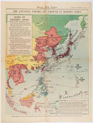
The Japanese Empire -- Its Growth in Modern Times
Published by Chicago Daily Tribune. December 161941., Chicago., 1619
Seller: Asia Bookroom ANZAAB/ILAB, Canberra, ACT, Australia
Association Member: ANZAAB ILAB
Seller rating 5 out of 5 stars
Printed colour map on a single newspaper leaf 50 x 41.5 cm; 60 x 45 cm (sheet), two inset legends, marginal browning and at the folds, but remarkably bright, in very good condition. Map of the Japanese Empire published in the Chicago Daily Tribune "The World's Greatest Newspaper" on December 16th 1941, 9 days after the bombing of Pearl Harbour. The two legends list the "Wars of Modern Japan" from 1894, with territorial gains marked, noting that "Each seizure of mainland areas has given Japan new field of raw materials." "? the historic Chicago Tribune was an innovator in color inks and printing, but also a pioneer in bringing colorful art in the form of illustrations, photographs, cartoons and advertisements to the average person in an everyday medium." [see The Janet A. Ginsburg Chicago Tribune Collection, Michigan State University Libraries.].
-
![Seller image for ?????????. [Saikin no Toa keisei zukai]. [Illustrated Map of the Most Recent Situation in East Asia]. for sale by Asia Bookroom ANZAAB/ILAB](https://pictures.abebooks.com/inventory/md/md32397051346.jpg)
?????????. [Saikin no Toa keisei zukai]. [Illustrated Map of the Most Recent Situation in East Asia].
Published by ???????. [Osaka Mainichi Shimbunsha]. Showa 12 [1937]., ??. [Osaka]., 1937
Seller: Asia Bookroom ANZAAB/ILAB, Canberra, ACT, Australia
Association Member: ANZAAB ILAB
Seller rating 5 out of 5 stars
Large colourful folding map of East Asia, measuring 79 x 109cm. Small holes at folding points and closed tears on the verso, now neatly repaired with Japanese washi. Some light general wear but overall a bright and clean copy of this interesting map. Published in late 1937, this colourful pictorial map shows the dynamic military situation in East Asia from the Japanese point of view. Showing somewhat inaccurate information with incomplete conclusions, this map provides a better understanding of why Japan made the ill-informed decision to escalate its invasion of China following the Marco Polo Bridge incident. The area covered includes Japan, Taiwan, China, and the Soviet Union, and attempts to show tensions along real and imagined zones of control. Information about Soviet and Chinese military power is also included on the map. These propaganda maps conveyed the extent of the Japanese government's ambition to the Japanese population, with the charming cartoon-style images of wildlife and other natural resources, industries and historical landmarks indicating the anticipated gains of Japanese foreign policy. Interestingly, positions of military forces, transport routes, defence structures, and radio transmission stations are also marked on the map, though many of these appear phantasmic and out of step with reality. An inset world map at lower left shows the area within a global context. Offering a glimpse into the incomplete information at the hands of the Japanese authorities, and perhaps in part understood by the mapmakers in the context of Chinese Communist and Soviet successes in Yan'an and Xinjiang, large sections of Qinghai, Gansu and Ningxia are marked as under Soviet influence. At this stage, this region was largely under the control of Kuomintang-aligned warlords, and although the region was implicitly threatened by underground Communist insurgents, so too was the rest of China. The focussed attention given to Communist influence and China's internal political divisions is indicative of the failure of Japanese planners to anticipate the cooperation of Communist and Nationalist forces in the face of Japanese aggression. The text box at right translated reads "Current State of Affairs in East Asia." In the legend, the coloured boxes indicate the following areas: reading right to left: Dark yellow: Japan Pale yellow: Manchukuo Red: Soviet Union (Russia) Pink: Sovietised area Purple: Republic of China (China) Grey: China (North China Buffer State, where a special relationship with Japan is emerging) Green: East Hebei Autonomous Government.
-
"Daily Mail" Map of the War in China.
Published by George Philip & Son. 1904-1905., London., 1904
Seller: Asia Bookroom ANZAAB/ILAB, Canberra, ACT, Australia
Association Member: ANZAAB ILAB
Seller rating 5 out of 5 stars
Colour folding map centred on the Bohai Sea, about the ongoing Russo-Japanese War. Divided into 18 panels, measuring 56 x 71cm when open, folds into card covers with "A Map of the Country between Pekin and Taku" printed in red inside the upper cover, covers measure 20.5 x 14cm. Map little foxed though not affecting image, few small holes at folds, covers worn and chipped, particularly at extremities, spine pf cover strengthened with archival tape, overall in good condition. A detailed map of China's northeast, extending from Nanjing and Shanghai in the south to Changchun in the north, showing the European concessions of Port Arthur, Weihaiwei and Qingdao. The Korean peninsula is also shown. Placenames are marked, as well as road and rail links. Curiously, although the South Manchuria Railway between Harbin and Port Arthur had been fully completed by the time of the war's outbreak and publication of this map, the line north of Kaiyuan appears to be marked as incomplete, perhaps indicating an asymmetric spread of knowledge regarding the railway's progress among British cartographers. Also shown are inset maps of central Beijing, the area around Guangzhou, as well as the Southeast of England to the same scale for comparison. A line map of the area between Beijing and Tianjin is included on the reverse of the upper cover.
-
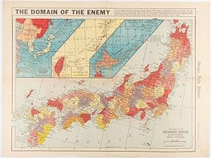
The Domain of the Enemy
Published by Chicago Daily Tribune. December 121941., Chicago., 1219
Seller: Asia Bookroom ANZAAB/ILAB, Canberra, ACT, Australia
Association Member: ANZAAB ILAB
Seller rating 5 out of 5 stars
Printed colour map on a single newspaper leaf 41.5 x 53 cm; 45.1 x 59.9 cm (sheet), three inset maps of the Japanese Empire; Taiwan and Ryukyu Islands; and Hokkaido and Chisima, marginal browning and at the central fold, but remarkably bright, in very good condition. Map of the Japanese Empire, ominously titled, published in the Chicago Daily Tribune one week after the bombing of Pearl Harbour. Prefectures are attractively coloured. Based on a Rand McNally map, the Tribune briskly got to work issuing maps for readers showing the beginnings of the war with Japan. Later maps were also published for sale separately, but remarkably few have survived. ". the historic Chicago Tribune was an innovator in color inks and printing, but also a pioneer in bringing colorful art in the form of illustrations, photographs, cartoons and advertisements to the average person in an everyday medium." [see The Janet A. Ginsburg Chicago Tribune Collection, Michigan State University Libraries.].
-
[Illustrated Bird's Eye View of the Current Situation in East Asia].
Publication Date: 1939
Seller: Geographicus Rare Antique Maps, Brooklyn, NY, U.S.A.
Association Member: ABAA ESA ILAB
Seller rating 4 out of 5 stars
Map
Soft cover. Average. Areas of discoloration and loss, especially along fold lines, repaired with infill on verso. Chips along edge. Size 30.25 x 20.25 Inches. An impressive large-format 1939 manga propaganda map of China and Korea compiled by a team led by political activist and union organizer Sengoku Kotaro and published as a supplement to the periodical Ie no hikari . It was published at the height of the Second Sino-Japanese War (1937 - 1945) (the Chinese theater of World War II), as Japan's initial advances slowed, and the war settled into a grueling stalemate. A Closer Look Coverage includes China, Mongolia, Manchuria, and Korea, with portions of surrounding territories. Cartoon figures representing farmers, soldiers, and workers of different nations appear throughout. Though outwardly innocuous, these illustrations reflect common, and often denigrating, Japanese perceptions of other Asian peoples, while also endorsing Japan's rationale for invading China in 1937. China is presented as a bountiful land of vast resources and hardy people, whose industriousness, it is implied, is only held back by ineffective government. Chinese farmers and laborers are seen lugging bags labeled 'wheat,' 'salt,' 'rice,' and so on, hinting at the resources that Japan hoped to acquire after the war. Aside from the large puppet state of Manchukuo towards top-right, figures in areas more recently occupied by Japanese troops, such as Beijing, Nanjing, and Inner Mongolia, wave flags and welcome Japan's benevolent influence. The depiction of Koreans is similarly loaded and self-serving, with an indolent yangban figure smoking opium, a peasant uprooting ginseng, and miners digging iron and coal. Conversely, soldiers and civilians of the Mongolian People's Republic (Outer Mongolia) and the Soviet Union are presented as obstinate and menacing, a threat all along the borders of Manchukuo and northern China. Aside from humans, animal figures, boats, and structures like the Great Wall of China are drawn to reflect regional characteristics. For instance, an unlucky goldminer in northern Heilongjiang, the northernmost point in China (or, rather, Manchukuo here), runs from an angry bear. Though Japanese and Chinese soldiers are not depicted, an inset map at bottom-right refers to the intense, ongoing conflict, indicating areas occupied by the Imperial Japanese Army as of the end of October 1938. The Second Sino-Japanese War The Second Sino-Japanese War was fought between the Republic of China, led by Chiang Kai-shek and the Guomindang (GMD, or Kuomintang KMT), and the Empire of Japan. Though generally dated to 1937, some scholars trace the beginning of the war to the Mukden Incident and the September 1931 Japanese invasion of Manchuria. In the following years, Japan established a puppet regime in Manchuria and extended its influence into northern China through several other 'incidents,' to the extent that it directly or indirectly controlled most of northern China and Inner Mongolia by 1937. Although determined to resist the Japanese, Chiang was eager to eliminate the domestic threat from the Communists first while also buying time to modernize his armies and gain better control over his generals, most of whom were semi-independent warlords. These plans were disrupted when Chiang was kidnapped by one of his own generals in December 1936 and forced to enter a united front with the Communists. Now compelled to turn his attention towards Japan, it was a matter not of if but when a full-scale war with Japan would come. The July 7, 1937 Marco Polo Bridge Incident has traditionally been considered the start of the war, when Chinese and Japanese troops began exchanging fire at the Marco Polo (Lugou) Bridge, along a main access route to Beijing. This exchange of fire escalated to an all-out battle leading to Japanese forces capturing both Beijing and its port city of Tianjin. As the conflict expanded, Chiang aimed to deliver a knockout blow before Japanese reserves could be.
-
![Seller image for [Latest Map of Ethiopia and Adjacent British, French and Italian Colonies]. for sale by Geographicus Rare Antique Maps](https://pictures.abebooks.com/inventory/md/md32307595264.jpg)
[Latest Map of Ethiopia and Adjacent British, French and Italian Colonies].
Publication Date: 1935
Seller: Geographicus Rare Antique Maps, Brooklyn, NY, U.S.A.
Association Member: ABAA ESA ILAB
Seller rating 4 out of 5 stars
Map
Soft cover. Very good. Light wear along original folds. Light soiling in lower right quadrant. Size 15.25 x 21 Inches. This is a 1935 Japanese-language map of Ethiopia and its environs published by the Tokyo Asahi Shimbun in tandem with the Abyssinian Crisis at the outbreak of the Second Italo-Ethiopian War (1935 -1937). The map illustrates a little-known episode in pre-WWII history wherein Japan and Ethiopia considered the creation of an 'Alliance of Non-White Peoples.' A Closer Look The map covers all of modern-day Ethiopia, as well as parts of Eretria, Somalia, Djibouti, Sudan, and Kenya. Settlements, roads, railways (including those under construction), waterways, mountains, and other features are labeled throughout, as indicated in the legend at the bottom left. Colonial possessions and protectorates are color-coded so that Italy's are bright green, Britain's pink, France's purple, and so on. An inset in the upper right situates Ethiopia in the context of North Africa, and a text block in the lower right describes the country's people, history, political system, and geography. Alliance of Non-White Peoples Japan's reaction to the Abyssinian Crisis is not well-known but is both unexpected and fascinating. As an increasingly militaristic and nationalistic society that had itself left the League of Nations the year prior after a nakedly imperialist land grab in Manchuria, Japan would presumably align with Italy's militarist, nationalist government set on a naked land grab against the wishes of the League of Nations. But the opposite was the case. This was largely retaliation for Italy's opposition to Japan's invasion of Manchuria and subsequent improved relations with China. However, there were also deeper and longer-term connections between Japan and Ethiopia. Both were ancient hereditary empires, never conquered or dependent upon another nation, and both considered themselves threatened and oppressed by foreign (Western) powers. Moreover, Japan saw Ethiopia as a means of extending its economic influence in Africa. Starting in 1931, the two countries improved diplomatic and economic relations, signing a commercial treaty and discussing a scheme for sending 150,000 Japanese immigrants to grow cotton in Ethiopia and a similarly ambitious plan to have tens of thousands of laborers build irrigation systems around Lake Tana. The 1931 Constitution of Ethiopia was partly modeled on the 1890 Meiji Constitution, and a faction of modernizers in Addis Ababa came to be called 'Japanizers.' The Ethiopians also increasingly saw Japan as a means of resisting Italian designs on their land, appealing to Tokyo to send them weapons after the December 1934 border clashes between Ethiopia and Italian Somaliland. In the following months, the Italian press denounced Japanese meddling. In Tokyo, parades were held supporting the Ethiopian cause. (For its part, the Japanese Legation to Rome was much more measured, focusing on protecting Japan's economic interests in Ethiopia.) An important part of these enmities was racial, and the Japanese discourse around the Abyssinian Crisis was clear about resisting the overbearing incursions of the white race (a proxy for Western criticism of Japan's expanding influence in China). At the same time, in an August 1935 speech, Mussolini invoked the 'Yellow Peril' in denouncing Japanese criticism of Italy's actions in Ethiopia, claiming that Japan planned to use Africa as 'a bridge which the Yellow race would use to attack the white race.' Nevertheless, after Italy occupied Ethiopia, negotiations began on mutual recognition of Italian Ethiopia and Manchukuo as part of a broader rapprochement resulting in the Anti-Comintern Pact. Still, the experience helped Japan hone its message as the leading member of the non-Western (non-white) world and a liberator of colonized people. This message would become central to the country's self-image in the following years. Second Italo-Ethiopian War The origins of the Second Italo-Ethiopian.
-
[??????. [Sangoku ts�ran zenzu]. [General Map of Three Countries].
Published by (Circa1790)., 1790
Seller: Asia Bookroom ANZAAB/ILAB, Canberra, ACT, Australia
Association Member: ANZAAB ILAB
Seller rating 5 out of 5 stars
Manuscript, ink and watercolour copy of this famous map which shows the disputed island of Dokdo/Takeshima. 52.3 x 71cm. Folded, some small areas of worming with neat washi repairs on reverse, browned at two corners not affecting the map itself, two red chops near corner. Overall a particularly attractive copy of this controversial map. The controversial Japanese book and five accompanying maps, 'Sangoku ts�ran zusetsu' published in 1785, describes the geography and customs of three countries - Kankoku (Korea) , Yezo or Ezo (present day Hokkaido), and Ry�ky� (present day Okinawa). At the time of its publication Ha Yezo was only partially occupied by the Tokugawa government and although from 1609 Ry�ky� was in reality under the control of the Shimazu clan in Satsuma (present Kagoshima Prefecture), the Shimazu clan allowed it to be an independent country superficially. Among the five maps published to accompany Sangoku ts�ran yochi (General Route Map of Three Countries), is a map of Japan and its neighbouring countries which this is a manuscript copy of. The other four maps are: a map of Ry�ky� (????), Yezo (?????), the eight provinces of Korea (?????), and Ogasawara Islands (????). This particular map, showing Japan and its neighbours attracts strong feelings even today as it shows the disputed islands, known to the Japanese as Takeshima ????/??, Dokdo - ??/?? to Koreans and Liancourt Rocks to English speakers, crucially marked as "Korea's possession". This is used by Korea as evidence for the legitimacy of their claim. The book and its accompanying maps, were an attempt to define Japan's borders and were banned on publication because the author, Hayashi Shihei, criticised Japanese maritime defence policy both in this and an earlier work. As frequently is the case, the banning of Sangoku ts�ran zusetsu did nothing to deter interest in what Hayashi Shihei had to say and copies of the maps were made and circulated underground. This copy appears to be one of these underground copies. Kanji numbers are neatly written in the border framing the map showing longitude and latitude. At first glance this suggests accuracy but in fact the map does not accurately reflect scientific knowledge in Japan at that period. Only a few years before in 1779 Nagakubo Sekisui published a much more accurate map of Japan. The map is imprecise, especially as the map maker moved further from the familiar regions of Honshu, Kyushu, and Shikoku. However it is clear that Hayashi Shihei's intention was not to concern himself with cartographical detail but, as he says on the map itself, "This is a small map to show the geographical relations between Japan and neighbouring countries such as Korea, Ry�ky�, Yezo, Sakhalin, Kamchatka, and Sea Otter Island [Urup]." As this text suggests, the purpose was to show the location of Japan amongst her neighbouring countries rather to give a precise description of Japan and these countries. Previously in Japan there had been not much interest in mapping the region outside of Japan however with the increasing visits and incursions into Japanese territory by Russians, Dutch and other outsiders it became important to define and clarify Japan's borders. The manuscript is not dated but almost certainly this copy was made in the late Edo period, late 18th to early 19th century.
-
![Seller image for ????????. [Sekai ni kagayaku gunkanki]. [Japanese Naval Ensigns throughout the World]. for sale by Asia Bookroom ANZAAB/ILAB](https://pictures.abebooks.com/inventory/md/md32183576913.jpg)
????????. [Sekai ni kagayaku gunkanki]. [Japanese Naval Ensigns throughout the World].
Published by ???. [Kaigunsh?]. Showa 4 [1929]., [Japan]., 1929
Seller: Asia Bookroom ANZAAB/ILAB, Canberra, ACT, Australia
Association Member: ANZAAB ILAB
Seller rating 5 out of 5 stars
Large colour folding map, black and white photographic illustrations, inset charts, 107.3 x 225cm. Paper browned and a little soiled in places, small holes at some fold points and edges neatly repaired with washi tissue on the verso. A handsome and striking map. This extra-large world map is richly illustrated with numerous photographic images showcasing the overseas activities of the Japanese Imperial Navy. It traces the sailing routes of naval training ships between 1925 and 1928 and features several black and white photographs of the ships and their crew during visits to locations such as Paris, Rome, Egypt, and China. Inset charts on both sides of the map illustrate the growth of Japanese naval power from 1894 to 1928, in comparison with foreign navies including those of Britain, France, and Russia. The timing of the map?s publication is noteworthy. At the time, Japan was adhering to naval power limits set in proportion to other nations, such as Britain and the United States, under the Washington Naval Treaty. However, the inset charts clearly show a significant increase in Japanese naval strength over the years. By the 1930s, the treaty?s influence had declined, and Japan formally withdrew in 1933 following its departure from the League of Nations.
-
![Seller image for ?????????. [Dait?a sens? sekai y?zu]. [World Map of the Greater East Asian War]. for sale by Asia Bookroom ANZAAB/ILAB](https://pictures.abebooks.com/inventory/md/md32182538049.jpg)
?????????. [Dait?a sens? sekai y?zu]. [World Map of the Greater East Asian War].
Published by ???????? [Daihonei Kaigun H?d?bu]. Showa 17 [1942]., Japan., 1942
Seller: Asia Bookroom ANZAAB/ILAB, Canberra, ACT, Australia
Association Member: ANZAAB ILAB
Seller rating 5 out of 5 stars
Large colour folding map, 165 x 215.8cm. Some strengthening of folds and neat repairs on reverse, small chip in margin, a little light browning on some folds but overall very good. This extra-large world map presents a detailed depiction of global wartime activity during the latter half of 1942. Japanese military campaigns and land and sea battles that occurred between 10 April and the end of September are marked in red, with all naval engagements included. The map highlights the growing intensity of conflict in Southeast Asia and the Pacific, areas that appear to have reached the height of military activity at the time of publication. In Europe, regions under German and Italian control are indicated with blue diagonal lines. A comprehensive legend identifies military, air, and submarine bases belonging to Germany, Italy, and the Allied nations, as well as territories occupied or bombed by Japanese forces.
-
![Seller image for [Sino-Japanese War and Resources]. for sale by Geographicus Rare Antique Maps](https://pictures.abebooks.com/inventory/md/md32068507785.jpg)
[Sino-Japanese War and Resources].
Publication Date: 1939
Seller: Geographicus Rare Antique Maps, Brooklyn, NY, U.S.A.
Association Member: ABAA ESA ILAB
Seller rating 4 out of 5 stars
Map
Soft cover. Good. The map exhibits wear, toning and light verso reinforcement along the fold lines. On the left side, there are also three equidistant holes in the paper that tantalizingly resemble gunshots from a moving automatic weapon. This however, is likely not the case. Each hole has been reinforced with matching paper on the verso. Size 36 x 24.25 Inches. A rare 1939 map of China during the Second Sino-Japanese War (1937 - 1845) issued by Kodansha for Fujin Kurabu , a Japanese women's magazine. The map was issued to propagandize the war effort on the home front. A Closer Look The map both resembles publications issued for similar men's magazines and is at the same time unique. Where the men's magazine maps are more colorful and elaborate chromolithograph productions, this map is a simpler three-color photo-lithograph. Moreover, unlike similar maps made for Sh?nen Club (Boy's Club), this map offers photographs of the war - something the all-women readers were considered unlikely to ever see. The images are sanitized, focusing on the glorification of Japanese military might, with little evidence of the extreme brutality for which the Second Sino-Japanese War became known. The Scope of the Map Coverage extends from Manchuria to Hainan, but is otherwise limited to eastern China, where the war was most heated. By 1939, Japanese forces penetrated deep into the Chinese interior, but the war reached a stalemate. While Japanese forces occupied the large cities, they lacked sufficient manpower to control China's vast countryside. Nonetheless, with the cities and major transportation networks under their control, the Japanese were eager to pursue the second part of their plan - harvesting China's natural resources for the war effort. Here these resources, ranging from food products, to ore and oil, are much in evidence. Text areas in the lower right promote other Kodansha publications intended for female audiences. The Second Sino-Japanese War The Second Sino-Japanese War was fought between the Republic of China and the Empire of Japan. Some disagreement exists as to when the war officially started. Two different 'Incidents' are used to mark the beginning of hostilities. Historically, the July 7, 1937 Marco Polo Bridge Incident is the official start, when Chinese and Japanese troops began exchanging fire at the Marco Polo (Lugou) Bridge, along a main access route to Beijing. This exchange of fire escalated to an all-out battle leading to Japanese forces capturing both Beijing and its port city of Tianjin. Other scholars, and since 2017 the Chinese government, trace the beginning of the Second Sino-Japanese War to the Mukden Incident and the September 1931 Japanese invasion of Manchuria. This 'incident' was based on trumped-up Japanese charges that their rights in Manchuria, which had been guaranteed following the Russo-Japanese War (1904 - 1905), were being infringed upon. More likely, the Japanese simply saw an opportunity to easily capture an essentially limitless supply of raw materials, a new market for their manufactured goods, and create a 'buffer zone' between Japanese-occupied Korea and the Soviet Union. After five months of fighting, in early 1932, the Japanese created the puppet state of Manchukuo and installed Puyi, the last Emperor of China, as its ruler. Even though there is some debate over when the war started, the result is the same: years of war, famine, atrocities, and death. Following the December 7, 1941 Japanese attack on Pearl Harbor, the Second Sino-Japanese War is usually folded into the China-Burma-India Theater of World War II (1939 - 1945). Although there is some debate on when the war began, there is no doubt when it ended. Following the atomic bombings of Hiroshima and Nagasaki in August 1945, the Japanese unconditionally surrendered to the Allies on September 2, 1945, bringing an end to the largest Asian war of the 20th century. Publication History and Census This map was printed by Kodansha (??????) on January 1.
-
![Seller image for [Latest Detailed Map of Beijing, Japanese Translation]. for sale by Geographicus Rare Antique Maps](https://pictures.abebooks.com/inventory/md/md32068517123.jpg)
[Latest Detailed Map of Beijing, Japanese Translation].
Publication Date: 1940
Seller: Geographicus Rare Antique Maps, Brooklyn, NY, U.S.A.
Association Member: ABAA ESA ILAB
Seller rating 4 out of 5 stars
Map
Hardcover. Very good. Light toning. Offsetting at top-right margin. Ink smudges and lines in left margin, evidently from original printing process. Size 31 x 21 Inches. This is a very rare 1940 bilingual (Chinese-Japanese) large format folding map of Beijing, published under the Japanese occupation during the Second Sino-Japanese War (World War II). Occupation Tourism This map was intended for the thousands of Japanese businessmen, tourists, and military or government figures who resided in or passed through Beijing during the war years. Although undoubtedly a document with political valence given the war and occupation, it was primarily intended for tourism. Beginning in the right margin and continuing to the left and bottom margins, information is provided on major tourist attractions beginning with the Forbidden City and its associated gates, lakes, and museums (the transition of the complex from a seat of political power to an historical and cultural relic was still recent and incomplete at this time). Next, more temples, palaces, and tombs in the Inner City, Outer City, and in the countryside surrounding the city (??) are listed. Curiously, the Great Wall of China (usually ???? in contemporary Japanese sources) is not mentioned, though hand-drawn red lines on the inset map at bottom show routes to Shahe (??), Gaoliying (???), and Shunyi (??), all in the direction of the Great Wall, suggesting that the map's original owner at least considered a trip to the wall. The reason for the wall's omission could be because it had not become anything like the easily accessible tourist site that it is today and was generally ignored in the first half of the 20th century, languishing in a state of disrepair. It may also have been because the wall had seen fighting between Japanese and Chinese forces in the recent past (1933) and was still partially in use by the Japanese military. Moreover, the Great Wall was touchy from the standpoint of the Japanese occupation, as some Chinese nationalists and leaders of the Communist Party had begun to use it as a symbol of the strength and longevity of the Chinese nation in the face of foreign invasion. Aside from the tourist sites themselves, the marginal notes provide 'representative' lists of theaters and movie houses, suggested itineraries and their associated costs, a brief history of the city, and information on streetcars, shopping, and dining. Street-level Beijing This map is remarkably detailed down to the individual street and building level, including the interior grounds of landmarks like the Forbidden City and Temple of Heaven. It reflects the division of the city adopted after the fall of the Qing Dynasty, where the Inner City was separated into six districts and the Outer City into five. The map assiduously marks temples, pagodas, government offices, streetcar lines and stations, railways, and more. The makers have even gone through the effort of naming most of the individual hutong (alleyway neighborhoods). Beijing in the Republican Era (1912 - 1949) Beijing has gone through many name changes over its history, and came to resemble the city shown here in the late 13th century as Dadu or Khanbaliq, the winter capital of the Mongol Yuan Dynasty. It became Beijing (meaning 'northern capital') in 1403, when the Ming Emperor Yongle moved the capital from Nanjing ('southern capital') to be closer to the front line of the ongoing war with the Mongols. Under the Ming, Beijing began to take on its modern form, with the Forbidden City, and the city walls protecting and separating the inner and outer city. The Qing Dynasty elaborated the already-grandiose Ming city with more palaces and parks. Beijing initially remained the national capital after the fall of the imperial dynasty and the transition to a republic in 1912, although central power remained weak. The imperial family continued to live in the Forbidden City until 1924, even after several failed attempts to restore the monarchy, most notably in 19.


![Seller image for ???????: 13 ????????????. [Hyo?jun Dai to?a bunzu: 13 Serebesu?Morukka shotou-hen]. [Standard Maps of Greater East Asia: 13 - Celebes and the Moluccas]. for sale by Asia Bookroom ANZAAB/ILAB](https://pictures.abebooks.com/inventory/md/md22849928631.jpg)
![Seller image for [Latest Detailed Map of China]. for sale by Geographicus Rare Antique Maps](https://pictures.abebooks.com/inventory/md/md32068517108.jpg)
![Seller image for ????????. [Meiji kaisei Tokyo zenzu]. [Revised in Meiji. Map of Tokyo]. for sale by Asia Bookroom ANZAAB/ILAB](https://pictures.abebooks.com/inventory/md/md31783334299.jpg)
![Seller image for ???????: 18??????. [Hyo?jun Dai to?a bunzu: 18 Hawai shoto?-hen]. Standard Maps of Greater East Asia: 18 - Hawaii for sale by Asia Bookroom ANZAAB/ILAB](https://pictures.abebooks.com/inventory/md/md31878065350.jpg)
![Seller image for ?????????. [Saishin Nichiro senkyoku chizu zen]. [The Most Recent Situation Map of the Russo-Japanese War]. for sale by Asia Bookroom ANZAAB/ILAB](https://pictures.abebooks.com/inventory/md/md32231404317.jpg)

![Seller image for [Illustrated Bird's Eye View of the Current Situation in East Asia]. for sale by Geographicus Rare Antique Maps](https://pictures.abebooks.com/inventory/md/md32068518178.jpg)
![Seller image for [??????. [Sangoku ts�ran zenzu]. [General Map of Three Countries]. for sale by Asia Bookroom ANZAAB/ILAB](https://pictures.abebooks.com/inventory/md/md32217514272.jpg)