

Order Total (1 Item Items):
Shipping Destination:

Map Manchuria Korea (5 results)
Skip to main search results
Search filters
Product Type
- All Product Types
- Books (2)
- Magazines & Periodicals (No further results match this refinement)
- Comics (No further results match this refinement)
- Sheet Music (No further results match this refinement)
- Art, Prints & Posters (No further results match this refinement)
- Photographs (No further results match this refinement)
- Maps (3)
- Manuscripts & Paper Collectibles (No further results match this refinement)
Condition Learn more
- New (No further results match this refinement)
- As New, Fine or Near Fine (No further results match this refinement)
- Very Good or Good (No further results match this refinement)
- Fair or Poor (No further results match this refinement)
- As Described (5)
Binding
- All Bindings
- Hardcover (No further results match this refinement)
- Softcover (No further results match this refinement)
Collectible Attributes
- First Edition (No further results match this refinement)
- Signed (No further results match this refinement)
- Dust Jacket (No further results match this refinement)
- Seller-Supplied Images (5)
- Not Print on Demand (5)
Language (1)
Price
- Any Price
- Under £ 20 (No further results match this refinement)
- £ 20 to £ 35 (No further results match this refinement)
- Over £ 35
Free Shipping
- Free Shipping to U.S.A. (No further results match this refinement)
Seller Location
Seller Rating
-
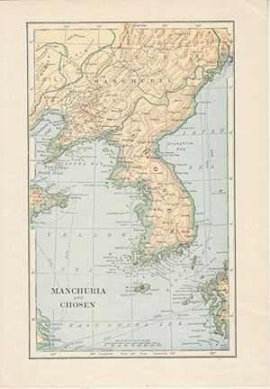
Manchuria and Chosen
Published by (Circa1900)., [London]., 1900
Seller: Asia Bookroom ANZAAB/ILAB, Canberra, ACT, Australia
Association Member: ANZAAB ILAB
Seller rating 5 out of 5 stars

Map printed in colour showing submarine and overland telegraphs, Manchuria, Chosen, Liao-Ting , Kirin and Chili, 21.5 x 13.3 cm, 25.7 x 17.1 cm (sheet size), margins a little scuffed, in very good condition.
-
?????????. [Saishin Nichiro senkyoku chizu zen]. [The Most Recent Situation Map of the Russo-Japanese War].
Published by ?????. [Denp? Ts?shinsha]. Meiji 37 [1904]., ??. [Tokyo]., 1904
Seller: Asia Bookroom ANZAAB/ILAB, Canberra, ACT, Australia
Association Member: ANZAAB ILAB
Seller rating 5 out of 5 stars
Fifth Edition. Colour folding map with four inset maps, 78.2 x 54.5cm, folds into light card covers measuring 21 x 14cm. Very good copy. This, the fifth edition of this map, was published on 7th June 1904 reflecting the high level of public interest in receiving up-to-date information on the war, particularly while the siege of Port Arthur continued without a decisive Japanese victory. The map includes four inset maps, among them detailed views of Port Arthur and Vladivostok. It also records distances between key ports in Japan, Korea, and China.
-

Carte deLa Tartarie Chinoise.
Publication Date: 1771
Seller: Geographicus Rare Antique Maps, Brooklyn, NY, U.S.A.
Association Member: ABAA ESA ILAB
Seller rating 4 out of 5 stars

Map
Very good. Some toning and wear along original centerfold. Minor foxing, especially over title. Original platemark visible. Size 12 x 17 Inches. A beautiful example of Rigobert Bonne's 1771 decorative map of Chinese Tartary. Covers from the Lop Nor region eastward to Korea, Manchuria, Sakalin and Jeso-Gasima (Hokkaido). Includes both Inner Mongolia and Outer Mongolia. Extends north to include Lake Baikal. Names numerous towns, cities and river systems. Shows the Great Wall of China. At the far eastern extreme of this map Jeso-Gasimia, or Hokkaido, is mapped speculatively along its northern shore. The island of Sahalien (or Sakhalin) also appears with erroneous shores. A decorative title cartouche appears in the lower right corner. This is an uncommon and rarely seen map. Drawn by R. Bonne in 1771 for issue as plate no. A 27 in Jean Lattre's Atlas Moderne . References: Rumsey 2612.059. National Library of Australia, MAP RM 198. Phillips (Atlases) 664. National Maritime Museum, 215.
-
![Seller image for [Tokyo Nichi Nichi Shimbun Japan-Russia War Map]. for sale by Geographicus Rare Antique Maps](https://pictures.abebooks.com/inventory/md/md32068516161.jpg)
[Tokyo Nichi Nichi Shimbun Japan-Russia War Map].
Publication Date: 1904
Seller: Geographicus Rare Antique Maps, Brooklyn, NY, U.S.A.
Association Member: ABAA ESA ILAB
Seller rating 4 out of 5 stars
Map
Good. Closed margin tears professionally repaired on verso. Verso repairs to fold separations and at fold intersections. Exhibits some soiling. Closed horizontal tear extending one half (.5) inch within printed area in lower central portion of map professionally repaired on verso. Size 15.75 x 21.74 Inches. This is a very rare 1904 or Meiji 37 bird's-eye view map of Northeast Asia covering Manchuria, Korea, and Japan. The view was distributed by the Japanese news daily Tokyo Nichi Nichi Shimbun . Its modified view style illustrates regional topography as well as major cities and ports relevant to the Russo-Japanese War (1904 - 1905). Transportation is Key The map also shows railways and other transportation networks critical to the war. Most notably, it shows the all-important China Eastern Railway, and its southern branch connecting Harbin (???) to Changchun (??), Mukden (Fengtian; ??), Jinzhou (??) and Port Arthur (???; Lüshunkou), one of the main causes and objectives of the war. The information at the bottom lists the distance between Port Arthur and towns near the frontlines, including distances using various routes, as well as the distances between some other strategically important towns and cities (Jiuliancheng, Harbin, Dashiqiao, Yingkou), and the distance by sea from Nagasaki to strategically important ports in Korea and China. Many of these place names would have been familiar to the Japanese reading public, which was inundated with information about the war in newspapers and would therefore have been able to use this map as a visual aid to daily updates about the progress of the war. The distances are marked by the Japanese unit of measurement ri (?), which is much longer (about 2.44 miles) than the traditional Chinese li , which uses the same character. Historical Context When this map was produced, the first major land battles of the war had just taken place. Japanese troops had recently crossed the Yalu River into Manchuria and also made progress in their siege of heavily entrenched Russian troops at Port Arthur (at left-center), taking Nanshan in Jinzhou (??), just next to Jinzhou Bay (???). By showing topography, rivers, and other geographical features in a three-dimensional perspective, the viewer gains some appreciation of the difficult terrain and limited infrastructure in Manchuria, which contributed to the length of the war. Russo-Japanese War The Russo-Japanese War, fought from February 8, 1904 - September 5, 1905, pitted Imperial Japan against Tsarist Russia over rival imperial ambitions in Manchuria and Korea. Both Russia and Japan had grand visions for the region. Russia traditionally had only one Pacific port, Vladivostok (???? here), which was operational only during the warm summer months. In 1898, Russia coerced China, then weakened after the First Sino-Japanese War (1894 - 1895), to lease them Port Arthur, a warm water port on the Liaodong Peninsula. They also negotiated a right-of-way to connect Port Arthur to the China Eastern Railway, which ran from nearby Jinzhou (Dalian, Dalniy) to Harbin, crossroads of the China Eastern Railway, which ultimately linked up with the Trans-Siberian Railway. Russia, eager to expand southwards from Siberia, considered Port Arthur the cornerstone of a sphere of influence covering Manchuria and Korea. Japan had its own imperial ambitions and saw itself as the natural overlord in East Asia, particularly after their victory in the First Sino-Japanese War (1894-1895). Korea and Manchuria in particular were important to the Japanese as steppingstones into China, with its seemingly unlimited resources. There was initially some attempt at negotiation between the imperialist powers, but Tsar Nicholas II arrogantly believed it impossible that Japan could challenge a major European power. Japan proved him wrong, launching a surprise attack on the Russian Eastern Fleet stationed at Port Arthur. The Russians were unable to defeat the Japanese at sea and steadily lost ground.
-

Detailed Map of the North Branch Incident / List all kinds of relations between Japan, Manchuria, Russia, Support, Mengo, and Japan. / / .
Publication Date: 1937
Seller: Geographicus Rare Antique Maps, Brooklyn, NY, U.S.A.
Association Member: ABAA ESA ILAB
Seller rating 4 out of 5 stars
Map
Very good. Some wear and verso reinforcement on old fold lines. Minor edge wear. Size 20.5 x 30.25 Inches. This is a rare Showa 12 or 1937 Japanese pictorial map of northeastern China, Manchuria, eastern Russia, Siberia, and Korea issued by the daily newspaper Tokyo Nichi Nichi Shimbun (???????). This map was published to illustrate the events of the July 7, 1838 Marco Polo Bridge Incident, the opening salvo of the Second Sino-Japanese War (1937 - 1945), and by extension, World War II (1939 - 1945). Centered on Beijing, the main map coves all of East Asia, from India to Japan, and from Siberia to Hainan Island. Pictorial elements, including flags, military aircraft, and battleships, illustrate zones of power and control. Smaller vignettes illustrate regional novelties (such as the Taj Mahal and Angkor Wat), flora, fauna, and resources - practically in Manchuria, the subject of the conflict. While the focus of the map is conflict between Japan and China, the dark defensive line surrounding Manchuria and the presence of Russian aircraft makes clear who Japanese considered to be the primary threat. A smaller map in the upper left details northeastern China. Portraits of Chinese military and political leaders line the left side of the map. Marco Polo Bridge Incident The Marco Polo Bridge Incident, also known as the Lugou Bridge Incident or the Double-Seven Incident, was a July 1937 battle between China's KMT led National Revolutionary Army and the Imperial Japanese Army. It is widely considered to be start of the Second Sino-Japanese War (1937 - 1945). Tensions in Manchuria were already at a high point due to the 1931 Mukden Incident. The bridge itself is an eleven-arch granite bridge constructed under the Great Jin (??; - 1234), but later restored by the Kanxi Emperor in 1698. Marco Polo famously references it in his journals, hence the name. The 'Incident' began with Japanese military exercises outside of the Chinese town of Wanping (???). An unknown contention led to a minor exchange of fire. When the Japanese returned to their base at Fengtai, they found a solider, Private Shimura Kikujiro, missing. Japanese officers demanded that they be allowed enter Wanping to search for the missing private - a demand that the Chinese flatly refused. Blustering commenced, with both sides sending reinforcements. Eventually, around 4AM on January 8, the Chinese Army opened fire on the Japanese at Marco Polo Bridge, roughly 210 meters south of Wanping. While suffering extreme losses, the Chinese were able to hold the bridge and peace negotiations began. While yielding a temporary truce, the peace ultimately fell apart and the Second Sino-Japanese War began in earnest. While some suggest the Marco-Polo Bridge Incident was staged by the Japanese. More likely, it came about naturally due to high tensions between the Chinese and Japanese in Manchuria. The Japanese, long eager to size Manchuria as a buffer zone against Russia, and exert greater control over China in general, merely took advantage of the opportunity. The Second Sino-Japanese War The Second Sino-Japanese War was fought between the Kuomintang (KMT) led Republic of China and the Empire of Japan between 1937 and 1945. Generally, the war is considered to have started with the July 7, 1937 Marco Polo Bridge Incident. Following the Battle at Marco Polo Bridge, Japanese forces proceeded to capture both Beijing and its port city of Tianjin. Most believe that the war staged by the Japanese who wanted greater influence in China and more control over the resource and labor rich Manchuria. After five months of fighting wherein the Japanese were mostly victorious, the puppet state of Manchukuo was created. Puyi, the exiled last Qing Emperor of China, was installed as its ruler. Following the Japanese attack on Pearl Harbor on December 7, 1941, the Second Sino-Japanese War is usually folded into the China-Burma-India Theater of World War II, which accounted for the majority of casualties during th.

![Seller image for ?????????. [Saishin Nichiro senkyoku chizu zen]. [The Most Recent Situation Map of the Russo-Japanese War]. for sale by Asia Bookroom ANZAAB/ILAB](https://pictures.abebooks.com/inventory/md/md32231404317.jpg)
