Hermann Moll (71 results)
 More images
- Hardcover
Seller: BoundlessBookstore, Wallingford, , United KingdomBoundlessBookstore
Contact seller5-star sellerCondition: Used - Good
£ 3.00
£ 6.98 shippingShips from United Kingdom to U.S.A.Quantity: 1 available
Condition: Good. 1st edition. Good condition book with dust jacket. DJ is clean, has fresh colours and has little wear to edges. Book has clean contents with light toning.
 More images
- Hardcover
Seller: BoundlessBookstore, Wallingford, , United KingdomBoundlessBookstore
Contact seller5-star sellerCondition: Used - Very good
£ 3.00
£ 6.98 shippingShips from United Kingdom to U.S.A.Quantity: 1 available
Condition: Very Good. Light wear to boards. Content is clean and bright. Toning to page ends. DJ with some edge wear and creasing.

- Hardcover
Seller: Sell Books, Elland, YORKS, United KingdomSell Books
Contact seller5-star sellerCondition: Used - Good
£ 3.60
£ 12.15 shippingShips from United Kingdom to U.S.A.Quantity: 1 available
hardcover. Condition: Good. Our good condition books are generally good for reading but not for gifting or collecting. They could have imperfections such as creasing, fanning, inscriptions, margin notes, yellowing, staining on edge or cover or pages, bumps, scuffs, etc etc (sometimes multiple of these). It's a wide category that… encompasses anything that isn't almost-new down to anything that is slightly better than poor. We would NOT recommend gifting Good books - these should be considered reading copies. Our books are dispatched from a Yorkshire former cotton mill. We list via barcode/ISBN so please note that the images are stock images and may not be the exact copy you receive, furthermore the details about edition and year might not be accurate as many publishers reuse the same ISBN for multiple editions and as we simply scan a barcode or enter an ISBN we do not check the validity of the edition data when listing. If you're looking for an exact edition please don't order (at least not without checking with us first, although we don't always have time to check). We aim to dispatch prompty, the service used will depend on order value and book size. We can ship to most countries, see our shipping policies. Payment is via Abe only.
- Hardcover
Seller: Military History Books, Weymouth, DORSE, United KingdomMilitary History Books
Contact seller2-star sellerCondition: Used
£ 9.20
£ 8.45 shippingShips from United Kingdom to U.S.A.Quantity: 1 available
(Subject: Post World War II - General) Moll, a German Arms merchant became enmeshed in an elaborate sting operation set up by US customs to trap dealers selling American weapons to Iran. At the pre-trial hearings he insisted that his deals had the approval of the US government but nobody believed him until the Iran Contra scanda…l broke and proved he was telling the truth. Members of Ronald Reagan's administration at that time included Oliver North, George Bush Snr, William Casey, Casper Weinberger and Rear-Admiral John Poindexter. (Published: 1988) (Publisher: Macmillan) (ISBN: 0333459423) (Pagination: 198pp) (Condition: dw edgeworn, ow vg) UL-XXXXXX.

- Hardcover
Seller: Cambridge Recycled Books, Cambridge, , United KingdomCambridge Recycled Books
Contact seller5-star sellerCondition: Used - Good
£ 5.00
£ 22.50 shippingShips from United Kingdom to U.S.A.Quantity: 1 available
hardcover. Condition: Good. Dust Jacket Condition: Good. Shelf wear to dust jacket.

Published by Macmillan 1988 1988
- Hardcover
Seller: Hard to Find Books NZ (Internet) Ltd., Dunedin, OTAGO, New ZealandHard to Find Books NZ (Internet) Ltd.
Contact seller5-star sellerCondition: Used
£ 7.84
£ 19.90 shippingShips from New Zealand to U.S.A.Quantity: 1 available
Ex-library, octavo hardcover (VG-) in d/w (VG-); all our specials have minimal description to keep listing them viable. They are at least reading copies, complete and in reasonable condition, but usually secondhand; frequently they are superior examples. Ordering more than one book will reduce your overall postage cost.
Published by London: 1709
- Map
Seller: Robert Frew Ltd. ABA ILAB, London, , United KingdomRobert Frew Ltd. ABA ILAB
Contact seller5-star sellerCondition: Used
£ 25.00
£ 10.00 shippingShips from United Kingdom to U.S.A.Quantity: 1 available
8.9 x 13.4 cm, sheet size 32 x 21 cm. Uncoloured. Engraved plan showing the fortifications of the city. Printed text above, below and on verso of image. Good condition.
Published by Freiburg Breisgau. Eisenbahn-Kurier. . 1983
- Hardcover
Seller: Antiquariat & Verlag Jenior, Kassel, HE, GermanyAntiquariat & Verlag Jenior
Contact seller5-star sellerCondition: Used
£ 33.79
£ 16.40 shippingShips from Germany to U.S.A.Quantity: 1 available
311 S. Hardcover. Sauberes Exemplar ohne Stempel und Anstreichungen. Gut erhalten. Zahlreiche Abbildungen und Tafeln. Sprache: deu.
Die Kreis Altenaer Eisenbahn (KAE) [Hardcover] Nebenbahndokumentation, Band 17 Deutsche Eisenbahngeschichte Ludger Kenning (Autor), Gerhard Moll (Autor), Wolf Dietrich Groote (Autor)
Hermann Bürnheim ; Gerhard Moll Ludger Kenning (Autor), Gerhard Moll (Autor), Wolf Dietrich Groote (Autor)
Language: English
Published by Kenning Freiburg. Eisenbahn-Kurier Verlag 1983 1983
- Hardcover
Seller: BUCHSERVICE / ANTIQUARIAT Lars Lutzer, Wahlstedt, GermanyBUCHSERVICE / ANTIQUARIAT Lars Lutzer
Contact seller4-star sellerCondition: Used - Very good
£ 62.20
£ 34.49 shippingShips from Germany to U.S.A.Quantity: 1 available
Hardcover. Condition: gut. 1983. Reihe/Serie Deutsche Eisenbahngeschichte Einbandart gebunden ISBN-10 3-88255-541-6 / 3882555416 ISBN-13 978-3-88255-541-7 / 9783882555417 Die Kreis Altenaer Eisenbahn (KAE) [Hardcover] Nebenbahndokumentation, Band 17 Ludger Kenning (Autor), Gerhard Moll (Autor), Wolf Dietrich Groote (Autor) In de…utscher Sprache. pages.
Published by MacMillan London 1988 1988
- First Edition
Seller: Andrew Barnes Books / Military Melbourne, Melbourne, VIC, AustraliaAndrew Barnes Books / Military Melbourne
Contact seller4-star sellerCondition: Used
£ 24.89
£ 14.92 shippingShips from Australia to U.S.A.Quantity: 1 available
1st edition dust jacket Fine octavo xi + 198pp., appendix, index, An insider's story of the Iran Arms Deals.
Language: German
Published by Freiburg Eisenbahn-Kurier ( ) 1983
- Hardcover
Seller: Müller & Gräff e.K., Stuttgart, GermanyMüller & Gräff e.K.
Contact seller5-star sellerCondition: Used
£ 22.23
£ 32.80 shippingShips from Germany to U.S.A.Quantity: 1 available
Gr.8°. 226 S. Mit zahlr. Abb., Plänen und Skizzen. Original-Pappband Gutes Exemplar. Gewicht (Gramm): 635.
15 Bücher: Nachts wenn das Licht ausgeht + Inspektor Thomsen geht zur Schule + An der schönen blauen Donau + Solange die Spur warm ist + Kriminalfälle ohne Beispiel + Orpheus im Frack + Die dunkle Grenze + Das Geheimnis des Wachsfigurenkabinetts + Galgenfriest + Monsieur bleibt im Schatten + Das graue Zimmer + Spione am Laufsteg + Warum starb Angele + Die deutsche Kriminalerzählung von Schiller bis zur Gegenwart Band 2 und Band 3
Hitchcock, Aklfred + Moll, Herbert + Spranger, Günter + Prodöhl. Günter + Hermann, Klaus+ Eichhorn - Nelson. Wally + Korobizin, Alexej + Harkenthal, Gerhard + Evertier, Paul 7 Taureau, Jean + Grabinsli, Stefan + Küster, Karl,- Heinz + Rinecker, Wolfgang + Greiner_ Mai, Herbert / Kruse, Hans Joachim ( Hsrg.)
Published by verschiedene Verlage
Seller: Versandantiquariat Kerzemichel, Wittenberge, , GermanyVersandantiquariat Kerzemichel
Contact seller5-star sellerCondition: Used
£ 26.67
£ 25.03 shippingShips from Germany to U.S.A.Quantity: 1 available
alle Bücher 8°, Einbände z. T. berieben bzw. leicht randrissig, einige haben farbigen Kopfschnitt, guter Zustand, über 1000 g.

- Softcover
- First Edition
Seller: Kunsthandlung Primavera Birgit Stamm, Dortmund, GermanyKunsthandlung Primavera Birgit Stamm
Contact seller5-star sellerCondition: Used - Fine
£ 14.68
£ 47.48 shippingShips from Germany to U.S.A.Quantity: 1 available
Farb. illustr. Orig.-Pappband. Condition: Sehr gut. Gr.-8°. 311 S. : 226 Ill., graph. Darst. u. Kt. Sehr gutes Exemplar der Erstausgabe. BITTE BEACHTEN SIE: KEIN VERSAND AN PACKSTATIONEN ! VERSAND INS AUSLAND MOMENTAN NUR nach Großbritannien, Japan, Schweiz, Irland, Frankreich, Spanien, Italien, Österreich, Belgien und die Niede…rlande! PLEASE NOTE: SHIPPING TO FOREIGN COUNTRIES AT THE MOMENT ONLY to Great Britain, Japan, Switzerland, Ireland, France, Spain, Italy, Austria, Belgium and the Netherlands! Schneller Versand auf Rechnung (Vorauszahlung vorbehalten) mit der Post bzw. DHL. Sprache: Deutsch Gewicht in Gramm: 800.
- Hardcover
Seller: Vangsgaards Antikvariat Aps, Copenhagen, , DenmarkVangsgaards Antikvariat Aps
Contact seller5-star sellerCondition: Used
£ 29.73
£ 25.41 shippingShips from Denmark to U.S.A.Quantity: 1 available
Eisenbahn-Kurier, Freiburg 1983. 8vo. 312 pages. Illustrations in b/w. Orig. boards. Near fine.
Language: English
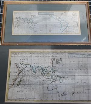
Published by (wohl aus Thomas Salman, Modern History, or the present state of all nations.) ( um 1739 ). 1739
- Map
Seller: Antiquariat im OPUS, Silvia Morch-Israel, Oppenheim, GermanyAntiquariat im OPUS, Silvia Morch-Israel
Contact seller5-star sellerCondition: Used - Very good
£ 301.42
£ 44.89 shippingShips from Germany to U.S.A.Quantity: 1 available
Condition: Gut. Grenzkolorierte Kupferstichkarte. Unter Passepartout, im Rahmen. Ursprünglich gefaltete Karte mit entsprechenden Knicken. Karte mit kleiner Beschädigung (am äußeren Rand kleine Fehlstelle Dreieck Seitenlänge ca. 5 mm). Insgesamt guter Zustand. Gewicht incl. Verpackung / Rahmen. Sprache: Englisch Gewicht in Gramm:… 2000 Passepartout-Ausschnitt beträgt ca. 53 x 19,7 cm.
- Hardcover
Seller: Antiquariat Der Papiersammler, Wetter, , GermanyAntiquariat Der Papiersammler
Contact seller4-star sellerCondition: Used
£ 27.96
£ 33.62 shippingShips from Germany to U.S.A.Quantity: 1 available
Eisenbahn-Kurier, ., 1983, , 311, Hardcover (gebunden), 8°, ohne Schutzumschlag, , Einband: minimal bestoßen, minimal fleckig, Seiten: minimal gebräunt.

- Hardcover
Seller: Lewitz Antiquariat, Parchim, MVP, GermanyLewitz Antiquariat
Contact seller5-star sellerCondition: Used - Fine
£ 80.02
£ 9.06 shippingShips from Germany to U.S.A.Quantity: 1 available
Hardcover/Pappeinband. Condition: Sehr gut. 311 Seiten mit 226 Illustrationen, Abbildungen und graph. Darstellungen und Karten. Kleiner Namensstempel auf dem hinteren Vorsatz. Kaum Lese- und Lagerspuren. Ein sehr gutes Exemplar. Sprache: Deutsch Gewicht in Gramm: 700.

Language: English
- Map
Seller: Hammelburger Antiquariat, Hammelburg, , GermanyHammelburger Antiquariat
Contact seller5-star sellerCondition: Used - Good
£ 66.69
£ 25.90 shippingShips from Germany to U.S.A.Quantity: 1 available
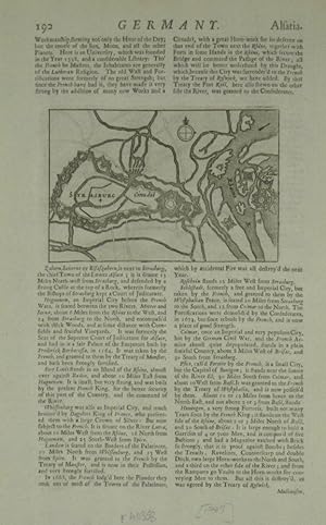
Condition: Befriedigend. "The North West Part of Germany" by Herman Moll, often found in editions around 1728 (or published in his Modern History series), is an antique map detailing the Northwestern region of the Holy Roman Empire, including parts of modern-day Westphalia, Lower Saxony, and the Netherlands. Key Features of the…1728 Region/Map: Germany, anno 1728, antique map by Moll Hermann, size of the printed area: 25 x 19 cm. Territories: The map covers the dominions of the Arch: and El: of Cologne, Westphalia (Juliers, Cleves), Munster, Osnaburgh, Holstein, Bremen, Hanover, Lunenburgh, Brunswick, and Hesse-Cassel. Geographical Scope: It depicts the Dutch Republic (United Provinces) on the left, extending through the Westphalian region to Lower Saxony and parts of Saxony/Franconia to the east. Details: It highlights cities, forts, and districts, often including detailed, artistic title cartouches in the style of 18th-century English cartography. Cartographer: Herman Moll (c. 1654-1732) was a London-based cartographer and engraver known for maps featuring significant artistic embellishments. These maps were often produced for Atlas Geographus or Modern History, reflecting the British interest in the European power dynamics of that period.
 More images
Published by Unpublished 1747-1821 1747
- Hardcover
- First Edition
- Map
Seller: Keoghs Books, Skipton, United KingdomKeoghs Books
Contact seller5-star sellerCondition: Used
£ 150.00
£ 28.00 shippingShips from United Kingdom to U.S.A.Quantity: 1 available
, assembled from a number of sources, including Moll's map of Berkshire, engraved views originally by Corbould, Thomas Hearne and others, including Windsor Castle, Donnington Castle, Donnington Grove, the Tythe Barn at Cholsey, one water colour of Windsor, a unique collection, folding plan of Windsor Castle (1749), dates given 1…747 - 1821 First Edition , ex-library copy with labels at front endpapers and small stamps on reverse of some leaves, front hinge cracked and spine detaching from text block, small paper number label at lower spine, head of spine scuffed, boards rubbed and lightly marked, corners bumped, small owner's signature on front pastedown, some illustrations lightly foxed but most are clean, in fair condition , dark green cloth Quarto Hardback ISBN.

Published by London, c.1710. 300 x 290mm (11¾ x 11½ inches). 1710
Seller: Tooley, Adams & Co., Wallingford, OXON, United KingdomTooley, Adams & Co.
Contact seller3-star sellerCondition: Used
£ 35.00
£ 37.15 shippingShips from United Kingdom to U.S.A.Quantity: 1 available
Uncoloured; trimmed close to line border on three sides, just clipping the printed surface on the right, signs of old folds from the book, otherwise prsentable. A map of England and Wales, showing and naming the rivers.
Published by London: printed for Christopher Brown, and sold by the following booksellers; Mr. Knapton, Mr. Knaplock, Mr. Wilkin, Mr. Tooke, Mr. Clark, Mr. Betsworth, Mr. Bowyer, Mr. Innis, Mr. Taylor, Mr. Osbourn, Mr. King, and Mr. Nicks, 1721. 1721
- Hardcover
Seller: Sam Gatteno Books, Grosse Pointe, MI, U.S.A.Sam Gatteno Books
Contact seller5-star sellerHardcover. Condition: Good. Octavo. 1ff., iv, [2]pp. Third edition. Modern half goatskin over marbled boards. With 32 handcolored maps on 29 folding plates. ESTC N18303.
Published by Thomas Bowles & Joh Bowles, london 1745
- Hardcover
Seller: Contact Editions, ABAC, ILAB, Toronto, ON, CanadaContact Editions, ABAC, ILAB
Contact seller5-star sellerCondition: Used - Near fine
£ 2,881.03
£ 24.61 shippingShips from Canada to U.S.A.Quantity: 1 available
Full Leather. Condition: Near Fine. Reprint. Full tree calf with leather title label gilt on spine. 36 hand coloured maps, all in great condition. All maps by Herman Moll. This work first published with England and Ireland in 1725. Size: Oblong Quarto. H. MOLL (illustrator). Book.
 More images
Published by Thomas Bennet; John Nicholson; and Daniel Midwinter, London 1705
- Hardcover
- First Edition
Seller: ecbooks, Orkney Islands, United Kingdomecbooks
Contact seller5-star sellerCondition: Used - Good
£ 4,800.00
£ 25.00 shippingShips from United Kingdom to U.S.A.Quantity: 1 available
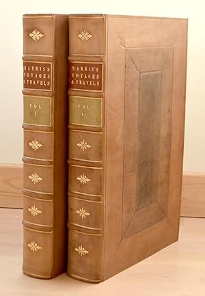
Full-Leather. Condition: Good. 1st Edition. A good copy of the 1st edition in recent full panelled calf bindings with 9 maps, 21 (of 22) plates, 2 frontispieces (one with loss) and 8 engravings in the text. John Harris (1633-1719) was an anglican priest and scientist, specialising in mathematics. He was admitted as an FRS in 169…6. His written works were well-regarded and popular and Navigantium was published in 2 further enlarged editions. The 1st edition is relatively scarce and is sought after particularly for the first printings of the Moll maps. The bindings are in near fine clean condition with gilt-lined raised bands to the spine with gilt decoration in the compartments and title and volume labels. There is light scuffing. Internally new endpapers and blanks have been added. This set has been matched against the reference copy held by the Hathi Trust and matches it apart from a misplaced plate, a missing plate, a small misbound section in the appendix and a misplaced map (America). There are numerous mispaginations without loss and a number of small repaired edge tears. Overall the set is very clean with occasional light marking. There are small library stamps to the top corner of the title pages, the verso of 2 maps (one per volume), and the top side margins of a couple of pages in each volume. Please enquire if you would like to see a full report of mispaginations and condition. Contents: Vol I: frontispiece (laid down and missing circa 30%); title; dedication 2 pp; to the Reader 2pp; subscribers' list 2pp; contents 6pp with tipped in paper strip; introduction pp i-lxvii; text pp 1-862 finis with 10 plates, 6 folding maps and 2 engravings in the text; index 1 - 6pp; index 2 - 8 pp finis. Vol II: frontispiece (laid down - some loss in gutter); title (with some expert repair); contents 4pp; folding map of the world; text pp 1-928 finis with 11 plates (one folding), 2 maps and 6 engravings in the text; appendix pp 1-56 with pp 41-48 bound after p 56 without loss; index 1 - 4pp; index 2 - 8pp; finis. Hermann Moll (illustrator).

- Hardcover
Seller: Buchmarie, Darmstadt, , GermanyBuchmarie
Contact seller4-star sellerCondition: Used - Very good
£ 86.95
£ 36.26 shippingShips from Germany to U.S.A.Quantity: 1 available
Condition: Very Good.
 More images
Published by H. Moll Ca 1724 1724
- Map
Seller: PROCTOR / THE ANTIQUE MAP & BOOKSHOP, DORCHESTER, United KingdomPROCTOR / THE ANTIQUE MAP & BOOKSHOP
Contact seller5-star sellerCondition: Used
£ 99.00
£ 20.00 shippingShips from United Kingdom to U.S.A.Quantity: 1 available
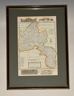
In black and gilt wooden frame, with glass. Size of engraved surface 12 x 7.5 inches. Frame 17 x 12 inches. In very good condition. A very bright and clean map. Detailed and highly decorative early 18th century map of Oxfordshire by Herman Moll. Features archaeological and historical illustrations to the borders including Blenhe…im House, The Bridge of Blenheim, Roman Pavement at Woodstock and Rollewrich Stones Engraved by the Dutch cartographer Herman Moll.
 More images
Published by H. Moll Ca 1724 1724
- Map
Seller: PROCTOR / THE ANTIQUE MAP & BOOKSHOP, DORCHESTER, United KingdomPROCTOR / THE ANTIQUE MAP & BOOKSHOP
Contact seller5-star sellerCondition: Used
£ 132.00
£ 20.00 shippingShips from United Kingdom to U.S.A.Quantity: 1 available
Ivory Mount Size of engraved surface 12.5 x 8 inches. Mount 17.5 x 13 inches. In very good condition. A very bright and clean map. With Illustrations of Gods on either side (Venus; Jupiter; Neptune; Hercules; Vulcan; Bacchus & ?), also with small vignette of The Roman Amphitheater at Dorchester ?now called Maumbury (Rings)..

Published by London: [nach ] 1736
- Art Print
Seller: Antiquariat Tautenhahn, Lübeck, , GermanyAntiquariat Tautenhahn
Contact seller5-star sellerCondition: Used
£ 80.02
£ 90.64 shippingShips from Germany to U.S.A.Quantity: 1 available
Kupferstich 18 x 25 cm, Blattgröße 22,5 x 34,5 cm. Die Karte zeigt detailliert das Gebiet von Nordwest Deutschland. Der Titel unten links, oben links ein Meilenanzeiger und seitlich einige Erklärungen. - Aus: Atlas minor or a new and curious Set of Sixty two Maps, in which are shewn all the Empires, Kingdoms, Countries, States,…in all the known parts of the Earth; with their Bounds, Divisions, Chief Cities & Towns, the whole composed & laid down agreable to modern History / by Herman Moll Geographer. - An den Rändern Spuren alter Rahmung, die Karte selbst ohne Makel.
Published by Artist: Moll Hermann ( - 1732 ) London ca : 1712 1654
Seller: Antique Sommer& Sapunaru KG, München, , GermanyAntique Sommer& Sapunaru KG
Contact seller4-star sellerCondition: Used
£ 160.05
£ 38.85 shippingShips from Germany to U.S.A.Quantity: 1 available
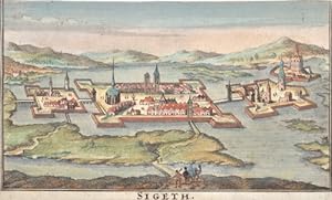
Technic: Copper print, colorit: original colored, condition: Margins cutted, size (in cm): 18 x 13 ,5, Szietvar is a town in Baranya County in southern Hungary. The town's fortress was the setting of the Battle of Szigetvár in 1566. It was a sanjak centre at first in Budin Province (1566?1601), later in Kanije Province (1601?168…9).
Published by London 1732
Seller: Argosy Book Store, ABAA, ILAB, New York, NY, U.S.A.Argosy Book Store, ABAA, ILAB
Contact seller5-star sellerCondition: Used - Very good
£ 230.48
£ 4.48 shippingShips within U.S.A.Quantity: 1 available
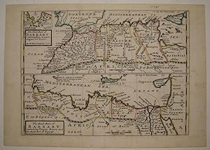
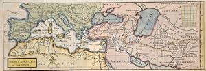
unbound. Condition: very good. Map. Copper plate engraving with original hand outline. Image measures 7 15/16" x 10.75". Fine antique map in two sections showing the northern coast of Africa from Morocco and the Strait of Gibraltar to Cyprus and the Red Sea. In addition to political boundaries and geographical features, Moll inc…ludes a few cultural and historical descriptions. Of Malta he writes "subject to a Grand Master who is always at war with the Turks", and he notes the pyramids and locations of castles and villages. A small inset at top left shows the Port of Oran.Herman Moll (c. 1654-1732) settled in London in the 1670's where he worked as an engraver for Moses Pitt. By the turn of the century, Moll became the foremost map publisher in England, where he produced Atlases and maps. As an engraver, cartographer, mapseller and globemaker he appealed to the public with his unusual views and vignettes. As the demand for his work was sustained, he issued many revised editions of his work.
Published by Artist: Moll Hermann ( - 1732 ) London ca : 1715 1654
Seller: Antique Sommer& Sapunaru KG, München, , GermanyAntique Sommer& Sapunaru KG
Contact seller4-star sellerCondition: Used
£ 204.50
£ 38.85 shippingShips from Germany to U.S.A.Quantity: 1 available
Technic: Copper print, colorit: colored, condition: Upper margin perfectly replaced, size (in cm): 8,5 x 25,5, Map shows the Mediterranean sea with sout Europe, north Africa and Asia minor.


