
Order Total (1 Item Items):
Shipping Destination:

B Hassenstein (35 results)
Skip to main search results
Search filters
Product Type
- All Product Types
- Books (26)
- Magazines & Periodicals (No further results match this refinement)
- Comics (No further results match this refinement)
- Sheet Music (No further results match this refinement)
- Art, Prints & Posters (No further results match this refinement)
- Photographs (No further results match this refinement)
- Maps (9)
- Manuscripts & Paper Collectibles (No further results match this refinement)
Condition Learn more
Binding
Collectible Attributes
- First Edition (2)
- Signed (No further results match this refinement)
- Dust Jacket (1)
- Seller-Supplied Images (18)
- Not Print on Demand (31)
Language (3)
Free Shipping
Seller Location
Seller Rating
-

The Junior Instructor, Book 2: A Treasure House of Adventure for Boys and Girls
Published by The United Educators, Inc., 1943
Seller: Once Upon A Time Books, Siloam Springs, AR, U.S.A.
Seller rating 4 out of 5 stars

hardcover. Condition: Acceptable. This is a used book. It may contain highlighting/underlining and/or the book may show heavier signs of wear . It may also be ex-library or without dustjacket. This is a used book. It may contain highlighting/underlining and/or the book may show heavier signs of wear . It may also be ex-library or without dustjacket.
-

Information and Control in the Living Organism: An Elementary Introduction
Language: English
Published by Chapman & Hall 1st English edn, 1971
ISBN 10: 0412106906 ISBN 13: 9780412106903
First Edition
Soft cover. Condition: Very Good. 1st Edition. 159p, 2 plates and many text figures, a very good paperback, with spine lettering renewed [0412106906].
-
Hard Cover. Condition: Good. No Jacket. Navy embossed boards, edges and hinges rubbed, corners and tips lightly chipped. Pages are clean, text has no markings, binding is sound. Size: 4to - over 9�" - 12" tall.
-

Couverture souple. Condition: Tr�s bon. 159 p. Call number and stamps (some on edge) of library.
-

Freiburger Vorlesungen zur Biologie des Menschen
Language: German
Published by Quelle & Meyer Verlag, Heidelberg, 1979
ISBN 10: 3494009740 ISBN 13: 9783494009742
Softcover. Condition: Gut. ISBN: 3494009740 - Softcover Buch guter Zustand - Erscheinungsjahr: 1979 - Buch mit Abbildungen und 224 Seiten - - Index: 500.
-
freiburger vorlesungen zur biologie des menschen
Published by quelle & meyer verlag, heidelberg, 1979
Seller: alt-saarbr�cker antiquariat g.w.melling, Saarbr�cken, Germany
Seller rating 4 out of 5 stars
First Edition
Broschiert. erste auflage. oktav orig.broschur. mit abbildungen; 224 seiten; am unteren rand kleine ansto�ung.
-
Die bisherige Rolle der Kybernetik in der biologischen Forschung.
Publication Date: 1960
Seller: Antiq. F.-D. S�hn - Medicusbooks.Com, Marburg, Germany
Seller rating 5 out of 5 stars

Nat.wiss. Rdsch., 13/9-11. - Stuttgart 1960, Gr.8�, 24 pp., orig. Broschur; leicht angest.
-

Karte der Reise von C. und A. Dempster, Clarkson und Harper im Innern von West-Australien, 1861. Ma�stab 1 : 1 000 000
Published by Justus Perthes, Gotha, 1863
Softcover. Condition: Gut. 42,8 x 24,5 cm Karte mit leichten Gebrauchsspuren, sonst GUTES EXEMPLAR---Petermanns Geographische Mittheilungen, Jahrgang 1863, Tafel 4 F�r Ihre Zufriedenheit versenden wir mit DHL und ausschlie�lich mit Trackingcode f�r eine sichere Sendungsverfolgung! Weitere Angebote unter antiquariat-kastanienhof , 1 Seiten. nein.
-

Softcover. Condition: Gut. 52,1 x 42,8 cm GUTES EXEMPLAR---Petermanns Geographische Mittheilungen, Erg�nzungsheft Nr. 15 F�r Ihre Zufriedenheit versenden wir mit DHL und ausschlie�lich mit Trackingcode f�r eine sichere Sendungsverfolgung! Weitere Angebote unter antiquariat-kastanienhof , 1 Seiten. nein.
-

Softcover. Condition: Gut. 28,8 x 24,6 cm GUTES EXEMPLAR---Petermanns Geographische Mittheilungen, Jahrgang 1864, Tafel 10 F�r Ihre Zufriedenheit versenden wir mit DHL und ausschlie�lich mit Trackingcode f�r eine sichere Sendungsverfolgung! Weitere Angebote unter antiquariat-kastanienhof , 1 Seiten. nein.
-

Erg�nzungsband: Ber�cksichtigend die Literatur bis ende 1934 nebst einem Generalregister des Gesamtwerkes (German Edition)
Seller: Ria Christie Collections, Uxbridge, United Kingdom
Seller rating 5 out of 5 stars
� 51.82
� 11.98 shipping
Ships from United Kingdom to U.S.A.Quantity: Over 20 available
Add to basketCondition: New. In.
-
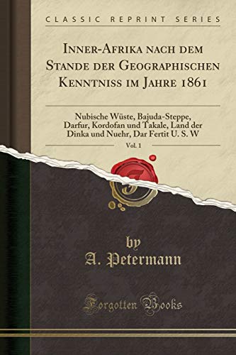
Paperback. Condition: New. Print on Demand. This book presents a detailed account of the author's 1860 journey through the Nubian Desert from Korosko to Berber. The author, a botanist, provides meticulous observations on the region's geography, vegetation, and wildlife, along with insights into the local culture and customs. Drawing upon scientific knowledge of the time, the book offers a valuable historical record of the natural and human environment of the Nubian Desert during the 19th century. Through detailed descriptions and analysis, the author sheds light on the challenges and rewards of scientific exploration in a remote and unforgiving landscape, showcasing the significance of preserving and understanding our natural heritage. This book is a reproduction of an important historical work, digitally reconstructed using state-of-the-art technology to preserve the original format. In rare cases, an imperfection in the original, such as a blemish or missing page, may be replicated in the book. print-on-demand item.
-
Ost-Afrika zwischen Chartum u. d. Rothen Meere bis Suakin u. Massaua. M. Anh. Th.v. Heuglin: Ein arab. Schriftsteller �ber d. Bedja-L�nder.
Published by Gotha Perthes, 1861
Seller: Zentralantiquariat Leipzig GmbH, Leipzig, Germany
Seller rating 5 out of 5 stars
4�. M. 1 Kte. 16 S. Ohne Umschl. R�cken m. Kleberest v. ehemaliger Bind. Teils etwas stockfleckrandig. (Petermanns geogr. Mitteil. Erg.-H. 6). Sprache: Deutsch 0 gr.
-

Inner-Afrika nach dem Stande der geographischen Kenntniss in den Jahren 1861 u. 1862. Nach den Quellen bearbeitet. Dritte Abtheilung: Originalbericht VI: Antinori's Reise zum Lande der Djur, 1860 u. 1861. Originalbericht VII: M. v. Beurmann's Aufenthalt in Mursuk und Reise nach Wau, 28. April bis 21. Juni 1862.
Published by Gotha: Perthes, 1862
Seller: Antiquariat Gallus / Dr. P. Adelsberger, Innsbruck, A, Austria
Seller rating 5 out of 5 stars
OBrosch. 4�, Tbl., pp. 79 - 96, mit 4 gro�formatigen gefalt Karten, 1) Mit der Originalkarte zu Beurmanns Reise von Bengasi nach Mursuk und Wau. 2) Tafel 5: Wadai und Bagirmi 3) Tafel 7: Bar-Banda 4) Tafel 9: Kongo - (= Erg�nzungsheft Nr. 10, zu Petermann's "Georgraphischen Mittheilungen") - Einwandfreier Erhaltungszustand.
-

Przewalskis Reise durch die Gobi-W�ste und den Kwen-Lun nach Tibet und zum Kuku-Nor 1879 u.1880. Reduktion der Original-Routenkarte in 1:2 000 000 auf den Massstab 1:3 500 000
Published by Justus Perthes, Gotha, 1883
Seller: Antiquariat Reinhold Berg eK Inh. R.Berg, Regensburg, Germany
Seller rating 5 out of 5 stars
Map
Lithograph, original color in outline and wash. August Heinrich Petermann (born April 18, 1822 in Bleicherode; September 25, 1878 in Gotha (suicide)) was one of the most famous geographers and cartographers of the 19th century.August Petermann is considered an excellent, internationally highly respected cartographer. After his training in Potsdam he worked in Edinburgh with Alexander Keith Johnston with British scholars, navigators and explorers on the English edition of Berghaus' Physical Atlas. His maps of population density and the spread of cholera in England stand out from the London era, illustrating not only social aspects of infectious diseases in the early stages of their medical research. With them, Petermann joined the founding generation of thematic maps.With the maps for Petermanns Mitteilungen, such more topographical characters come to the fore. The publisher of the magazine benefited from innovations in card technology in Gotha: Bernhardt Perthes (18211857, grandson of the company founder) had developed an electro-chemical process for duplicating copperplate plates with electroplating, which drastically reduced the amount of work and time required allowed the production of map excerpts. Emil von Sydow had brought color lithography to production maturity in card manufacture, which also increased productivity and made it possible to use color on a broad scale for conveying information in cards. After more than a decade of practice, both card technologies had their teething problems and the combination of both techniques in card production behind them. With great organizational talent, Petermann turned this lead into a best seller. Since Petermann not only reconstructed the travel routes but also integrated them into maps, many authors saw this as a great advantage and turned to the communications for the purpose of implementation, which was usually done quickly and in an appealing quality. No magazine was published without a map insert, and 25 to 35 map inserts were published per year. The development effort for this was comparable to that for a school atlas. The synthetic approach in the presentation of the new discoveries sometimes brought hypothetical aspects with it, which led to annoyance or even controversy between the authors and the very self-confident editor.These maps were not only used for communications, they were also important sources for the three revised editions of Stieler's Hand-Atlas, in which Petermann played a decisive role. The redesign of the hand atlases is thanks to his influence. The scales were converted to the international metric system. In addition to the politico-geographical statements, physical-geographical statements such as the representation of deserts, periodically water-bearing rivers, numbers for sea depths, height numbers, names of peaks, etc. have been added to larger-scale additional maps for areas of high population density. With the growth of cities in the 19th century, the representation of places became more dense, and an objectified, leaner, but still legible font was developed for the increased names. In Hermann Berghaus and Carl Vogel (18281897), Petermann was assisted by outstanding cartographers, and Vogel in particular developed a significantly improved relief representation in hatches. The high content density and display quality repeatedly resulted in complaints about black copies.The development of the atlas maps in the division of labor between up to seven map processors, engravers, lithographers, printers and other workers required the development of a specific business organization. The changeover from the publishing system to the factory system, begun by publisher Bernhardt Perthes, also required Petermann's organizational talent after his early death. But experts at Gothaer Anstalt disagree with the view that Petermann had a managerial function. It cannot be overlooked that Petermann developed little sense for theoretical questions of cartography and.
-
Originalkarte einer Reiseroute von Lad� bis Dara. Ma�stab: 1:2.000.000. Aus Petermann
Published by Gotha, Perthes 1881.
Condition: -. Gefaltete, kolorierte, lithographische Karte. Gr��e: Ca. 50 x 20 cm. Im Rand stellenweise sehr gering fleckig. Kleiner Randeinri�. Beiliegend: Der entsprechende 10seitige Aufsatz "Aufzeichnungen �ber die Route von Lad� nach Dara" von Robert W. Felkin aus : Petermann, A.: Mittheilungen aus Justus Perthes Geographischer Anstalt. Bd. 27, 1881. Die Karte nach der Itinerar-Aufnahme von R. W. Felkin und C. T. Wilson von 1879.
-

Geologische Karte eines Teiles des n�rdlichen Island von Th. Thoroddsen, 1896.
Published by Justus Perthes, Gotha, 1898
Seller: Antiquariat Reinhold Berg eK Inh. R.Berg, Regensburg, Germany
Seller rating 5 out of 5 stars
Map
Other. Lithograph, original color in outline and wash. In excellent condition. 230 by 190mm (9 by 7� inches). 230 by 190mm (9 by 7� inches).
-

Kindliche Sozialisation und Sozialentwicklung. ( = Fortschritte der Sozialp�diatrie, 2) .
Language: German
Published by Urban& Schwarzenberg M�nchen, 1978
ISBN 10: 3541066520 ISBN 13: 9783541066520
Hardcover/ Pappband. Condition: Gut. 194 Verhaltensbiologie Klinische Psychologie Verhaltenstherapie Kind Guter Zustand Mit Abb. ha1057590 Sprache: Deutsch Gewicht in Gramm: 350.
-

Karte von H.M. Lefroy's Expedition im Innern von West-Australien. Mai bis Juli 1863. - Gezeichnet von B. Hassenstein.
Published by Justus Perthes, Gotha, 1864
Seller: Antiquariat Reinhold Berg eK Inh. R.Berg, Regensburg, Germany
Seller rating 5 out of 5 stars
Map
Other. Lithograph, original hand colored. The map was originally published folded, so that the old folds are still slightly visible. In excellent condition. 246 by 386mm (9� by 15� inches). 246 by 386mm (9� by 15� inches).
-

Dr. Sven Hedin's Reiseroute durch Kan-Su, Ala-Schan und Ordos 1896 und 1897. Nach dem Tagebuch entworfen und gezeichnet von Dr. B. Hassenstein.
Published by Justus Perthes, Gotha, 1900
Seller: Antiquariat Reinhold Berg eK Inh. R.Berg, Regensburg, Germany
Seller rating 5 out of 5 stars
Map
Other. Lithograph, original color in outline and wash. In excellent condition. The map was originally published folded, so that the old folds are still slightly visible. 395 by 481mm (15� by 19 inches).
-

Originalkarte der Strasse zwischen Berber & Sauakin in Nubien. - Nach den Aufnahmen und einer Manuskriptkarte Theodor von Heuglin s. gezeichnet von B. Hassenstein.
Published by Justus Perthes., Gotha, 1866
Seller: Antiquariat Reinhold Berg eK Inh. R.Berg, Regensburg, Germany
Seller rating 5 out of 5 stars
Map
Other. Lithograph, hand colored in outline when published. Small detailed map showing the street between Berber and Sauakin in Nubia. Ornated with a small detailed inset map of the port of Sauakin with interesting details of Coral banks, a destroyed fort and old graves. In excellent condition. 193 by 260mm (7� by 10� inches). 193 by 260mm (7� by 10� inches).
-
Epistolae. Ed. J. Mart�nek et D. Mart�nkov�. 2 vol.
Published by (Leipzig) Teubner -80, 1969
Seller: Zentralantiquariat Leipzig GmbH, Leipzig, Germany
Seller rating 5 out of 5 stars
OLwd. (Bibl. Teubneriana). 1: Epistolae de re publica scriptae. 2: Epistolae ad familiares. la 0 gr.
-
NUEVA ANTOLOG�A. Tomo 4: ANTROPOLOG�A CULTURAL.
Seller: Librer�a Mireya (C/Andr�s Mellado, 68), Madrid, M, Spain
Seller rating 2 out of 5 stars

Barcelona, Ediciones Omega, 1976. 12x19, 496pgs. R�stica. Buen estado. ENSAYOS. ANTROPOLOG�A. FILOSOF�A.
-
NUEVA ANTOLOG�A. Tomos 1 y 2: ANTROPOLOG�A BIOL�GICA.
Seller: Librer�a Mireya (C/Andr�s Mellado, 68), Madrid, M, Spain
Seller rating 2 out of 5 stars
Barcelona, Ediciones Omega, 1976. 12x19, 358+439pgs. R�stica. Buen estado. ENSAYOS. ANTROPOLOG�A.BIOLOG�A.
-

Karte von Horn's Expedition in Zentral-Australien unter F�hrung von Ch. Winnecke, 1894. Mit Benutzung aller fr�heren Reisen und Aufnahmen entw. u. gezeichnet von Dr. B. Hassenstein.
Published by Justus Perthes, Gotha, 1898
Seller: Antiquariat Reinhold Berg eK Inh. R.Berg, Regensburg, Germany
Seller rating 5 out of 5 stars
Map
Other. Lithograph, original color in outline as published. In excellent condition. The map was originally published folded, so that the old folds are still slightly visible. 356 by 426mm (14 by 16� inches). 356 by 426mm (14 by 16� inches).
-
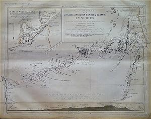
1866 Original Map of the Road between Berber and Suakin in Nubia. After the Surveys and the Manuscript Map of Theodore von Heuglin. Drawn by B. Hassenstein. Inset of the Port of Suakin from the Manuscript Map of Theodore von Heuglin and the Surveys of Capt. W Pullen 1858-59.
Language: German
Published by Justus Perthes, Gotha, 1866
Map
No Binding. Condition: Very Good. B. Hassenstein (illustrator). In German: Originalkarte de Strasse Zwischen Berber & Sauakin in Nubien. Nach dem Aufnahmen und einer Manuskriptkarte Theodor von Heuglin's. Gezeichnet von B. Hassenstein. Der Hafen von Sauakin. Nach einem Manuskriptplan Th. V. Heuglin's un der Aufnahme des Capt. W. Pullen 1858-59. Also includes a profile of the route between Berber and Suakin The base maps are black and white, the route on the main map is marked in red, and shorelines or regional boundaries on both maps are shown in pastel peach. From "Mittheilungen aus Justus Perthes' Geographischer Anstalt uber Wichtige Neue Erforschungen auf dem Gessammtgebiete der Geographie von Dr. A. Petermann, 1866." Roughly: "Communications from Justus Perthes' Geographical Institute Concerning Important New Studies in the Whole Field of Geography by Dr. Augustus Petermann, 1866." Condition notes: 10.4" wide X 8.5" high, modestly toned, mild page waviness.
-

1863 Map of the Trip of C. & A. Dempster, Clarkson & Harper in the Interior of Western Australia, July & August 1861. According to the Journal of B. Hassenstein.
Language: German
Published by Justus Perthes, Gotha, 1863
Map
No Binding. Condition: Very Good. In German: Karte der Reise von C. & A. Dempster, Clarkson & Harper im Innern von West Australien, Juli & August 1861. Nach dem Tagebuch construirt von B. Hassenstein. This map is entirely in black and white. From "Mittheilungen aus Justus Perthes' Geographischer Anstalt uber Wichtige Neue Erforschungen auf dem Gessammtgebiete der Geographie von Dr. A. Petermann, 1863." Roughly: "Communications from Justus Perthes' Geographical Institute Concerning Important New Studies in the Whole Field of Geography by Dr. Augustus Petermann, 1863." Condition notes: 17.7"wide X 10.4"high, in 3 panels (folded twice), modestly toned, mild page waviness.
-

Karte von J. Palliser's Expedition sur Erforschung der Rocky Mountains in Britisch-Nord-Amerika
Published by Gotha, Germany, 1860
Seller: Alexandre Antique Prints, Maps & Books, Toronto, ON, Canada
Seller rating 4 out of 5 stars
Map
Condition: Excellent. Size : 245x435 (mm), 9.625x17.125 (Inches), Original Outline Coloring.
-
Inner-Afrika nach dem Stande der geographischen Kenntniss in den Jahren 1861 bis 1863. Nach den Quellen bearbeitet. Nebst Original-Berichten von M. von Beurmann, Kotschy, Brun-Rollet, Behm, Antinori, Th. von Heuglin, Morlang und von Harnier. 4 Theile.
Seller: Herman H. J. Lynge & S�n ILAB-ABF, Copenhagen, Denmark
Seller rating 4 out of 5 stars
Gotha, Julius Perthes, 1862-63. 4to. Contemp. hcalf., spine gilt. A few scattered brownspots. Lithographed frontispiece. XII,50,80,78,(2),79-164 pp. 10 large folded lithographed maps with outline colouring. With general titlepage "Mittheilungen, Erg.-Bd.", General titlepage with map (Skizze von Inner Afrika). A small stamp to first general titlepage. (Petermann's "Geographischen Mittheilungen", Erg�nzungsband II. 1862/1863).
-
Die Inseln des Sudl. Indischen Oceans, meist nach Englischen aufnahmen zusammengestellt von A. Petermann
Publication Date: 1858
Seller: Antipodean Books, Maps & Prints, ABAA, Garrison, NY, U.S.A.
Association Member: ABAA ANZAAB ESA ILAB
Seller rating 4 out of 5 stars
Condition: Good + overall. The islands of the Southern Indian ocean, also known as the Desolation Islands, in the sub Antarctic region. Written in German with multiple images on one page showing various views of the island group. 8 3/4 x 10 3/4", dusty.
