Map Oregon by Rand Mcnally (43 results)

Seller: Lakeside Books, Benton Harbor, MI, U.S.A.Lakeside Books
Contact seller5-star sellerCondition: New
£ 4.18
£ 2.97 shippingShips within U.S.A.Quantity: 6 available
Condition: New. Brand New! Not Overstocks or Low Quality Book Club Editions! Direct From the Publisher! We're not a giant, faceless warehouse organization! We're a small town bookstore that loves books and loves it's customers! Buy from Lakeside Books.

Seller: Lakeside Books, Benton Harbor, MI, U.S.A.Lakeside Books
Contact seller5-star sellerCondition: New
£ 5.59
£ 2.97 shippingShips within U.S.A.Quantity: 2 available
Condition: New. Brand New! Not Overstocks or Low Quality Book Club Editions! Direct From the Publisher! We're not a giant, faceless warehouse organization! We're a small town bookstore that loves books and loves it's customers! Buy from Lakeside Books.

Seller: BargainBookStores, Grand Rapids, MI, U.S.A.BargainBookStores
Contact seller5-star sellerCondition: New
£ 8.72
Free ShippingShips within U.S.A.Quantity: 2 available
Sheet Map, Folded. Condition: New. Rand McNally Easy to Read: Oregon State Map. Book.
Seller: Rarewaves USA, OSWEGO, IL, U.S.A.Rarewaves USA
Contact seller5-star sellerCondition: New
£ 9.04
Free ShippingShips within U.S.A.Quantity: 1 available
Map. Condition: New.

Seller: Idaho Youth Ranch Books, Boise, ID, U.S.A.Idaho Youth Ranch Books
Contact seller5-star sellerCondition: Used - Good
£ 6.11
£ 2.97 shippingShips within U.S.A.Quantity: 1 available
Condition: Good. A copy that has been read, but remains in clean condition. All pages are intact, and the cover is intact (including dust cover, if applicable). The spine may show signs of wear. Pages can include limited notes and highlighting, and the copy can include "From the library of" labels or limited small stickers. Book… may have a remainder mark or be a price cutter.
Seller: California Books, Miami, FL, U.S.A.California Books
Contact seller4-star sellerCondition: New
£ 9.98
Free ShippingShips within U.S.A.Quantity: 6 available
Condition: New.
Seller: California Books, Miami, FL, U.S.A.California Books
Contact seller4-star sellerCondition: New
£ 9.98
Free ShippingShips within U.S.A.Quantity: 13 available
Condition: New.

Published by Rand McNally
Seller: World of Books (was SecondSale), Montgomery, IL, U.S.A.World of Books (was SecondSale)
Contact seller5-star sellerCondition: Used - Good
£ 4.72
Free ShippingShips within U.S.A.Quantity: 1 available
Condition: Good. Item in good condition. Textbooks may not include supplemental items i.e. CDs, access codes etc.

- Map
Seller: Gulf Coast Books, Cypress, TX, U.S.A.Gulf Coast Books
Contact seller5-star sellerCondition: Used - Very good
£ 12.11
Free ShippingShips within U.S.A.Quantity: 1 available
map. Condition: Very Good.

Published by Rand McNally & Company 2004
Seller: Foggypaws, Sonoma, CA, U.S.A.Foggypaws
Contact seller5-star sellerMap. Condition: Good. Rand McNally Oregon map in good condition. There is a small 1 inch tear to the front and a light crease to the cover. Other than that, this map is in great shape.

Published by Rand McNally & Co, Chicago IL 1916
- Softcover
- Art Print
Seller: Dorley House Books, Inc., Hagerstown, MD, U.S.A.Dorley House Books, Inc.
Contact seller4-star sellerCondition: Used - Very good
£ 6.53
£ 6.45 shippingShips within U.S.A.Quantity: 1 available
Unbound. Condition: Very Good. 5.5" x 7'' map, suitable for framing Size: 5.5" x 7''. Colored Map (illustrator).

Published by Rand McNally & Company
Seller: Idaho Youth Ranch Books, Boise, ID, U.S.A.Idaho Youth Ranch Books
Contact seller5-star sellerCondition: Used - Good
£ 6.90
£ 2.97 shippingShips within U.S.A.Quantity: 1 available
Condition: Good. A copy that has been read, but remains in clean condition. All pages are intact, and the cover is intact (including dust cover, if applicable). The spine may show signs of wear. Pages can include limited notes and highlighting, and the copy can include "From the library of" labels or limited small stickers. Book… may have a remainder mark or be a price cutter.
- Map
Seller: Revaluation Books, Exeter, , United KingdomRevaluation Books
Contact seller5-star sellerCondition: New
£ 7.60
£ 10.00 shippingShips from United Kingdom to U.S.A.Quantity: 2 available
map. Condition: Brand New. 9.70x0.30x4.40 inches. In Stock.
- Map
Seller: Revaluation Books, Exeter, , United KingdomRevaluation Books
Contact seller5-star sellerCondition: New
£ 8.40
£ 10.00 shippingShips from United Kingdom to U.S.A.Quantity: 2 available
Map. Condition: Brand New. 2 pages. 4.56x0.21x8.97 inches. In Stock.
- Softcover
Seller: WorldofBooks, Goring-By-Sea, WS, United KingdomWorldofBooks
Contact seller5-star sellerCondition: Used - Very good
£ 20.00
£ 5.60 shippingShips from United Kingdom to U.S.A.Quantity: 1 available
Paperback. Condition: Very Good. The book has been read, but is in excellent condition. Pages are intact and not marred by notes or highlighting. The spine remains undamaged.
Seller: Russell Books, Victoria, BC, CanadaRussell Books
Contact seller5-star sellerCondition: New
£ 6.14
£ 14.90 shippingShips from Canada to U.S.A.Quantity: 18 available
map. Condition: New. Special order direct from the distributor.
Seller: Russell Books, Victoria, BC, CanadaRussell Books
Contact seller5-star sellerCondition: New
£ 6.75
£ 14.90 shippingShips from Canada to U.S.A.Quantity: 6 available
map. Condition: New. Special order direct from the distributor.
Language: English
Published by Rand McNally, Chicago 1907
Seller: Bohemian Bookworm, Flemington, NJ, U.S.A.Bohemian Bookworm
Contact seller1-star sellerCondition: Used - Very good
£ 23.00
£ 2.98 shippingShips within U.S.A.Quantity: 1 available
No Binding. Condition: Very Good. Minor dampstaining along margins and onto map on lower corners, local railroads in red, 2-sided, ready for framing, uncut, uncreased, map measures 19" x 26". Counties in various colours.
Published by Rand McNally & Co, Chicago, IL 1919
- Softcover
Seller: Larry W Price Books, Portland, OR, U.S.A.Larry W Price Books
Contact seller5-star sellerCondition: Used - Very good
£ 30.33
£ 3.69 shippingShips within U.S.A.Quantity: 1 available
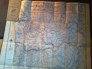
Pamphlet. Condition: Very Good. 43 pp.+ 16 pp. Illus Ads, Lge Color Dble-sided FoldOut Map at back (28 x 21 inches), Brn Paperback, 12mo (4.25 x 6.5 inches), sm repaired edgetear at spine else VG including the Map which is very nice with no tears.
Seller: AussieBookSeller, Truganina, VIC, AustraliaAussieBookSeller
Contact seller5-star sellerCondition: New
£ 19.04
£ 27.58 shippingShips from Australia to U.S.A.Quantity: 1 available
Folded. Condition: new. Folded. Shipping may be from our Sydney, NSW warehouse or from our UK or US warehouse, depending on stock availability.
Seller: AussieBookSeller, Truganina, VIC, AustraliaAussieBookSeller
Contact seller5-star sellerCondition: New
£ 20.19
£ 27.58 shippingShips from Australia to U.S.A.Quantity: 1 available
Folded. Condition: new. Folded. Shipping may be from our Sydney, NSW warehouse or from our UK or US warehouse, depending on stock availability.
Language: English
Published by Rand McNally & Company, Chicago 1923
- Softcover
Seller: Antiquariat im Schloss, Schwaigern, D, GermanyAntiquariat im Schloss
Contact seller5-star sellerCondition: Used
£ 41.77
£ 30.20 shippingShips from Germany to U.S.A.Quantity: 1 available
8° , Broschiert. 1 Blatt, 86 x 67 cm mehrfach gefaltet. Einband berieben und angerissen, Ecke geknickt, Plan guter Zustand. Sprache: Englisch Gewicht in Gramm: 900.
Seller: Rarewaves USA United, OSWEGO, IL, U.S.A.Rarewaves USA United
Contact seller5-star sellerCondition: New
£ 13.35
£ 37.27 shippingShips within U.S.A.Quantity: 1 available
Map. Condition: New.
Seller: CitiRetail, Stevenage, United KingdomCitiRetail
Contact seller5-star sellerCondition: New
£ 13.49
£ 37.00 shippingShips from United Kingdom to U.S.A.Quantity: 1 available
Folded. Condition: new. Folded. Shipping may be from our UK warehouse or from our Australian or US warehouses, depending on stock availability.
- Softcover
Seller: GoldBooks, Denver, CO, U.S.A.GoldBooks
Contact seller5-star sellerCondition: New
£ 76.29
£ 4.10 shippingShips within U.S.A.Quantity: 1 available
Paperback. Condition: new. New Copy. Customer Service Guaranteed.
 More images
Language: English
Published by Rand McNally, Chicago 1921
- Softcover
- First Edition
- Map
Seller: Books & Bidders, Cleveland, OH, U.S.A.Books & Bidders
Contact seller5-star sellerCondition: Used - Very good
£ 95.98
Free ShippingShips within U.S.A.Quantity: 1 available
Wrappers. Condition: Very Good. First Edition. Printed wraps (softcover), 6.5 x 4 inches. 38 pages, plus period advertisements; with double-sided color map bound-in at rear (Oregon Highway Map and Oregan Railroad Map). Unfolded map dimension 28 x 20.75 inches. Contains Railroads, Electric Lines, Post Offices, Express Telegraph a…nd Mail Service. Counties, Congressional Townships, Cities, Towns, Villages, Rivers, Lakes, Islands, Creeks, Mountains, Etc. Air Service and Landing Fields. Population according to Latest Official Census. and Main Highways. Map is near fine in wrappers showing some wear and rubbing. A desirable and scarce item.

Seller: Art Source International Inc., Boulder, CO, U.S.A.Art Source International Inc.
Contact seller5-star sellerWith the 19th century innovations of publishing and technology, the world became a smaller place and one which anyone could become acquainted with. As these changes blossomed, the fledgling company of Rand McNally realized the interest in small accessible material, and produced a pocket atlas. These maps carry handy reference in…formation, and were up to date for the period. They include cities, some towns as well as some roads. They have their own charm and would be great for framing, and decorative use. This map measures 3 inches by 5 inches.
Language: English
- Hardcover
- Print on Demand
Seller: S N Books World, Delhi, , IndiaS N Books World
Contact seller5-star sellerLeatherBound. Condition: NEW. BOOKS ARE EXEMPT FROM IMPORT DUTIES AND TARIFFS; NO EXTRA CHARGES APPLY. Leather Binding on Spine and Corners with Golden leaf printing on spine. Bound in genuine leather with Satin ribbon page markers and Spine with raised gilt bands. A perfect gift for your loved ones. Reprinted from 1892 edition.… NO changes have been made to the original text. This is NOT a retyped or an ocr'd reprint. Illustrations, Index, if any, are included in black and white. Each page is checked manually before printing. As this print on demand book is reprinted from a very old book, there could be some missing or flawed pages, but we always try to make the book as complete as possible. Fold-outs, if any, are not part of the book. If the original book was published in multiple volumes then this reprint is of only one volume, not the whole set and contains approximately 32 pages. IF YOU WISH TO ORDER PARTICULAR VOLUME OR ALL THE VOLUMES YOU CAN CONTACT US. Resized as per current standards. Sewing binding for longer life, where the book block is actually sewn (smythe sewn/section sewn) with thread before binding which results in a more durable type of binding. Language: English Volume 1892.

Seller: Art Source International Inc., Boulder, CO, U.S.A.Art Source International Inc.
Contact seller5-star sellerRand McNally & Company, still a major name in map publishing to this day, began as a small print shop opened in Chicago in 1856 by William H. Rand. The shop originally printed guidebooks and directories. In 1858, Rand hired Andrew McNally who was later to become a partner. Within the next few years, the shop got into the railroa…d business by starting to print railway tickets and schedules, a key step in the development of the company. The ticket printing led to the publishing of railway guides, and by 1872 Rand McNally and Company had the capacity to publish maps. This map of Oregon came from Rand McNallys Commercial Atlas. A highly successful run of atlases that lasted over a decade. These maps were primarily used by business, because of their accurate listing of railroads in operation as well as tables of statistical information. This map measures 26 inches by 19 inches.


