
Order Total (1 Item Items):
Shipping Destination:

Berlin Intelligence Map by Unknown (10 results)
Skip to main search results
Search filters
Product Type
- All Product Types
- Books (8)
- Magazines & Periodicals (No further results match this refinement)
- Comics (No further results match this refinement)
- Sheet Music (No further results match this refinement)
- Art, Prints & Posters (No further results match this refinement)
- Photographs (No further results match this refinement)
- Maps (2)
- Manuscripts & Paper Collectibles (No further results match this refinement)
Condition Learn more
- New (10)
- As New, Fine or Near Fine (No further results match this refinement)
- Very Good or Good (No further results match this refinement)
- Fair or Poor (No further results match this refinement)
- As Described (No further results match this refinement)
Binding
- All Bindings
- Hardcover (No further results match this refinement)
- Softcover (1)
Collectible Attributes
- First Edition (No further results match this refinement)
- Signed (No further results match this refinement)
- Dust Jacket (No further results match this refinement)
- Seller-Supplied Images (5)
- Not Print on Demand (10)
Language (1)
Price
- Any Price
- Under � 20
- � 20 to � 35 (No further results match this refinement)
- Over � 35 (No further results match this refinement)
Free Shipping
Seller Location
Seller Rating
-
Berlin Intelligence Map (Map)
Language: English
Published by Pen & Sword Books Ltd, London, 2001
ISBN 10: 1870067339 ISBN 13: 9781870067331
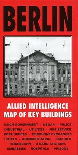
Map. Condition: new. Map. Published specially by After the Battle to coincide with the suspension of Allied occupation rights in Berlin in October 1990, this map was produced in 1944 by the War Office and lists the location and use of all important buildings in Berlin to be used in the occupation of the city. Every building associated with the Reich Government, NSDAP, police, fire service, Reichsbahn, U-Bahn, hospitals, telephone exchanges, embassies, prisons, etc., is numbered and referenced to an index printed on the reverse of the map. This sheet covers the central area at 1:12500. Published specially by After the Battle to coincide with the suspension of Allied occupation rights in Berlin in October 1990, this map was produced in 1944 by the War Office and lists the location and use of all important buildings in Berlin to be used in the occupation of the city. Shipping may be from multiple locations in the US or from the UK, depending on stock availability.
-

Berlin Intelligence Map
Language: English
Published by Pen and Sword Books Ltd, 2001
ISBN 10: 1870067339 ISBN 13: 9781870067331
Seller: PBShop.store UK, Fairford, GLOS, United Kingdom
Seller rating 5 out of 5 stars

UNK. Condition: New. New Book. Shipped from UK. Established seller since 2000.
-
Map. Condition: Brand New. 11.61x5.98x0.16 inches. In Stock.
-
Map. Condition: Brand New. 11.61x5.98x0.16 inches. In Stock.
-
Berlin Intelligence Map
Seller: Ria Christie Collections, Uxbridge, United Kingdom
Seller rating 5 out of 5 stars
Condition: New. In.
-

Berlin Intelligence Map (Map)
Language: English
Published by Pen & Sword Books Ltd, London, 2001
ISBN 10: 1870067339 ISBN 13: 9781870067331
Map. Condition: new. Map. Published specially by After the Battle to coincide with the suspension of Allied occupation rights in Berlin in October 1990, this map was produced in 1944 by the War Office and lists the location and use of all important buildings in Berlin to be used in the occupation of the city. Every building associated with the Reich Government, NSDAP, police, fire service, Reichsbahn, U-Bahn, hospitals, telephone exchanges, embassies, prisons, etc., is numbered and referenced to an index printed on the reverse of the map. This sheet covers the central area at 1:12500. Published specially by After the Battle to coincide with the suspension of Allied occupation rights in Berlin in October 1990, this map was produced in 1944 by the War Office and lists the location and use of all important buildings in Berlin to be used in the occupation of the city. Shipping may be from our Sydney, NSW warehouse or from our UK or US warehouse, depending on stock availability.
-
Condition: NEW.
-

Berlin Allied Intelligence Map of Key Buildings | Allied intelligence map of key buildings - Produced in 1944
Language: English
Published by Petersen Buchimport GmbH, 2001
ISBN 10: 1870067339 ISBN 13: 9781870067331
Taschenbuch. Condition: Neu. Berlin Allied Intelligence Map of Key Buildings | Allied intelligence map of key buildings - Produced in 1944 | Taschenbuch | Karte/Landkarte | Englisch | 2001 | Petersen Buchimport GmbH | EAN 9781870067331 | Verantwortliche Person f�r die EU: Petersen Buchimport GmbH, Weidestr. 122a, 22083 Hamburg, vertrieb[at]petersen-buchimport[dot]com | Anbieter: preigu.
-

Berlin Intelligence Map
Language: English
Published by Pen & Sword Books Ltd, 2001
ISBN 10: 1870067339 ISBN 13: 9781870067331
Condition: New. Published specially by After the Battle to coincide with the suspension of Allied occupation rights in Berlin in October 1990, this map was produced in 1944 by the War Office and lists the location and use of all important buildings in Berlin to be used in .
-

Berlin Intelligence Map
Language: English
Published by Pen & Sword Books Ltd Jan 2001, 2001
ISBN 10: 1870067339 ISBN 13: 9781870067331
Karte. Condition: Neu. Neuware - Published specially by After the Battle to coincide with the suspension of Allied occupation rights in Berlin in October 1990, this map was produced in 1944 by the War Office and lists the location and use of all important buildings in Berlin to be used in the occupation of the city. Every building associated with the Reich Government, NSDAP, police, fire service, Reichsbahn, U-Bahn, hospitals, telephone exchanges, embassies, prisons, etc., is numbered and referenced to an index printed on the reverse of the map. This sheet covers the central area at 1:12500.