Order Total (1 Item Items):
Shipping Destination:

Sdu (176 results)
Author:
sdu
Refine with Advanced Search
Skip to main search results
Search filters
Product Type
- All Product Types
- Books (95)
- Magazines & Periodicals (No further results match this refinement)
- Comics (No further results match this refinement)
- Sheet Music (No further results match this refinement)
- Art, Prints & Posters (1)
- Photographs (No further results match this refinement)
- Maps (80)
- Manuscripts & Paper Collectibles (No further results match this refinement)
Condition Learn more
Binding
Collectible Attributes
- First Edition (2)
- Signed (No further results match this refinement)
- Dust Jacket (No further results match this refinement)
- Seller-Supplied Images (163)
- Not Print on Demand (176)
Language (4)
Free Shipping
Seller Location
Seller Rating
-

Instinctive Shooting for Defense and Combat: The Israeli Method
Language: English
Published by Schiffer Military History (edition 1), 2017
ISBN 10: 076435311X ISBN 13: 9780764353116
Paperback. Condition: Fair. 1. The item might be beaten up but readable. May contain markings or highlighting, as well as stains, bent corners, or any other major defect, but the text is not obscured in any way.
-

Instinctive Shooting for Defense and Combat: The Israeli Method
Language: English
Published by Schiffer Military History, 2017
ISBN 10: 076435311X ISBN 13: 9780764353116
Condition: good. This book is in good condition with very minimal damage. Pages may have minimal notes or highlighting. Cover image on the book may vary from photo. Ships out quickly in a secure plastic mailer.
-

Instinctive Shooting for Defense and Combat: The Israeli Method
Language: English
Published by Schiffer Military History, 2017
ISBN 10: 076435311X ISBN 13: 9780764353116
Condition: good. The item shows wear from consistent use, but it remains in good condition and works perfectly. All pages and cover are intact including the dust cover, if applicable . Spine may show signs of wear. Pages may include limited notes and highlighting. May NOT include discs, access code or other supplemental materials.
-
Instinctive Shooting for Defense and Combat: the Israeli Method: The Israeli Method
Language: English
Published by Schiffer Military History, 2017
ISBN 10: 076435311X ISBN 13: 9780764353116
Soft cover. Condition: Fair. Book has a tear a bottom of spine and a small amount of highlighting. Elsewhere, minor wear. ***PROMPT, PROFESSIONAL SERVICE!***.
-

Instinctive Shooting for Defense and Combat: The Israeli Method
Language: English
Published by Schiffer Military History, 2017
ISBN 10: 076435311X ISBN 13: 9780764353116
Seller: Goodwill of Greater Milwaukee and Chicago, Racine, WI, U.S.A.
Seller rating 5 out of 5 stars

Condition: good. Book is considered to be in good or better condition. The actual cover image may not match the stock photo. Hard cover books may show signs of wear on the spine, cover or dust jacket. Paperback book may show signs of wear on spine or cover as well as having a slight bend, curve or creasing to it. Book should have minimal to no writing inside and no highlighting. Pages should be free of tears or creasing. Stickers should not be present on cover or elsewhere, and any CD or DVD expected with the book is included. Book is not a former library copy.
-

Instinctive Shooting for Defense & Combat : The Israeli Method
Language: English
Published by Schiffer Military History, 2017
ISBN 10: 076435311X ISBN 13: 9780764353116
Condition: As New. Unread book in perfect condition.
-

Instinctive Shooting for Defense & Combat : The Israeli Method
Language: English
Published by Schiffer Military History, 2017
ISBN 10: 076435311X ISBN 13: 9780764353116
Condition: New.
-

Condition: good. Befriedigend/Good: Durchschnittlich erhaltenes Buch bzw. Schutzumschlag mit Gebrauchsspuren, aber vollst�ndigen Seiten. / Describes the average WORN book or dust jacket that has all the pages present.
-
Condition: very good. Gut/Very good: Buch bzw. Schutzumschlag mit wenigen Gebrauchsspuren an Einband, Schutzumschlag oder Seiten. / Describes a book or dust jacket that does show some signs of wear on either the binding, dust jacket or pages.
-

Condition: good. Befriedigend/Good: Durchschnittlich erhaltenes Buch bzw. Schutzumschlag mit Gebrauchsspuren, aber vollst�ndigen Seiten. / Describes the average WORN book or dust jacket that has all the pages present.
-

Condition: very good. Gut/Very good: Buch bzw. Schutzumschlag mit wenigen Gebrauchsspuren an Einband, Schutzumschlag oder Seiten. / Describes a book or dust jacket that does show some signs of wear on either the binding, dust jacket or pages.
-

Condition: very good. Gut/Very good: Buch bzw. Schutzumschlag mit wenigen Gebrauchsspuren an Einband, Schutzumschlag oder Seiten. / Describes a book or dust jacket that does show some signs of wear on either the binding, dust jacket or pages.
-
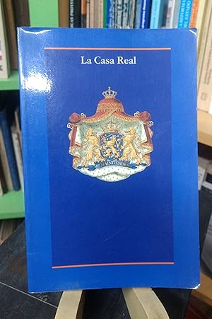
La casa real del reino de los Pa�ses Bajos
Language: Spanish
Published by Sdu Uitgevers, La Haya, 1996
Seller: Librer�a El Pez Volador, Rosario, SF, Argentina
Seller rating 5 out of 5 stars
First Edition
Encuadernaci�n de tapa blanda. Condition: Muy Bien. 1? Edici�n. Libro en MUY BUEN estado. 21x14cm.
-

Instinctive Shooting for Defense and Combat: the Israeli Method
Language: English
Published by Schiffer Publishing Ltd, 2017
ISBN 10: 076435311X ISBN 13: 9780764353116
Kartoniert / Broschiert. Condition: New. Über den AutorFabrizio Comolli has for years been involved in armed and unarmed defense training courses with SDU and collaborates with the team on many projects. He manages the Combat series for Edizioni Libreria Militare.
-

South America sheet III South Brazil with Paraguay and Uruguay
Language: English
Published by London, 1837
Seller: Bolivar Old Prints Anticuario, Barcelona, B, Spain
Seller rating 5 out of 5 stars
Condition: Good. [Descripci�n en espa�ol a continuaci�n] This map illustrates the territories of Paraguay, Uruguay and the south of Brazil. Published in London in 1837 by the Society for the Diffusion of Useful Knowledge (S.D.U.K.), it is distinguished by its composition. During the 19th century, the European powers showed great interest in South America, which led to a growing production of detailed cartography. This map forms part of that effort to document strategic regions. The use of shading makes it possible to visualise the relief of the region clearly. Important localities stand out such as Montevideo, Buenos Aires and the R�o de la Plata in the south; Asunci�n and the Paraguay River in the west; and in the north, Brazilian regions such as Mato Grosso, Goyaz, Pernambuco and Bah�a. Key cities are also included such as S�o Paulo, Rio de Janeiro, Porto Alegre and Porto Seguro. South America. Sheet III. South Brazil with Paraguay and Uruguay -------------------- Este mapa ilustra los territorios de Paraguay, Uruguay y el sur de Brasil. Publicado en Londres en 1837 por la Society for the Diffusion of Useful Knowledge (S.D.U.K.), se distingue por su composici�n. Durante el siglo XIX, las potencias europeas mostraban un gran inter�s por Sudam�rica, lo que llev� a una creciente producci�n cartogr�fica detallada. Este mapa forma parte de ese esfuerzo por documentar regiones estrat�gicas. El uso del sombreado permite visualizar el relieve de la regi�n con claridad. Se destacan importantes localidades como Montevideo, Buenos Aires y el R�o de la Plata al sur; Asunci�n y el r�o Paraguay al oeste; y al norte, regiones brasile�as como Mato Grosso, Goyaz, Pernambuco y Bah�a. Tambi�n se incluyen ciudades clave como S�o Paulo, R�o de Janeiro, Porto Alegre y Porto Seguro.
-

South America sheet IV La Plata and Chil�
Language: English
Published by London, 1840
Seller: Bolivar Old Prints Anticuario, Barcelona, B, Spain
Seller rating 5 out of 5 stars
Condition: Good. [Descripci�n en espa�ol a continuaci�n] Coloured map of the north of Chile and Argentina. On it we can observe the administrative borders differentiated by colours of the regions of Bolivia, Chile, Argentina, Patagonia, Paraguay, Uruguay and Brazil. Worth noting is the regional differentiation that we can see on the map between the Republic of Argentina and Patagonia. This map was published in London in the year 1840 by the S.D.U.K. ("Society for the Diffusion of Useful Knowledge"). This British society was an organisation dedicated to the dissemination of knowledge by means of accessible and detailed maps. It published atlases and geographical charts of high quality, promoting cartographic education. Its works combined precision and affordability, broadening access to geography. Worth noting is the appearance on the map of the Juan Fern�ndez archipelago. As for the illustration, we can see how, to show us the relief, shading is used that accompanies the map. We are also shown various lakes and lagoons with a bluish tone that make them stand out from the rest of the geographical features. Among the most notable localities that we find on the map we can see Buenos Aires, Montevideo, Asunci�n, C�rdoba, San Luis, San Juan and Santiago. In addition, on this map we find that Atacama forms part of Bolivian territory and that it gave it access to the sea, but this territory would come to form part of Chile at the end of that same century. -------------------- Mapa detalladamente coloreado del norte de Chile y Argentina. En �l podemos observar las fronteras administrativas diferenciadas por colores de las regiones de Bolivia, Chile, Argentina, Patagonia, Paraguay, Uruguay y Brasil. Cabe destacar la diferenciaci�n regional que podemos ver en el mapa entre la Rep�blica de Argentina y la Patagonia. Este mapa se public� en Londres en el a�o 1840 por la S.D.U.K. ("Society for the Diffusion of Useful Knowledge"). Esta sociedad brit�nica fue una organizaci�n dedicada a la divulgaci�n del conocimiento mediante mapas accesibles y detallados. Public� atlas y cartas geogr�ficas de alta calidad, promoviendo la educaci�n cartogr�fica. Sus trabajos combinaron precisi�n y asequibilidad, ampliando el acceso a la geograf�a. Cabe destacar la aparici�n en el mapa del archipi�lago de Juan Fern�ndez. En cuanto a la ilustraci�n, podemos ver c�mo para mostrarnos el relieve se hace uso de sombreados que acompa�an el mapa. Tambi�n se nos muestran diferentes lagos y lagunas con un tono azulado que las hacen destacar respecto al resto de figuras geogr�ficas. Entre las localidades m�s rese�ables que encontramos en el mapa podemos ver Buenos Aires, Montevideo, Asunci�n, C�rdoba, San Luis, San Juan y Santiago. Adem�s, en este mapa encontramos que Atacama forma parte del territorio boliviano y que daba acceso al mar al mismo pero este territorio pasar�a a formar parte de Chile a finales de ese mismo siglo.
-

South America sheet III South Brazil with Paraguay and Uruguay
Language: English
Published by London, 1844
Seller: Bolivar Old Prints Anticuario, Barcelona, B, Spain
Seller rating 5 out of 5 stars
Condition: Good. [Descripci�n en espa�ol a continuaci�n] Map of the regions of Paraguay and Uruguay, as well as a large part of the south of Brazil and a small area of the north of Argentina. This map was published in London in the year 1844 by the S.D.U.K. ("Society for the Diffusion of Useful Knowledge"). This British society was an organisation dedicated to the dissemination of knowledge by means of accessible and detailed maps. It published atlases and geographical charts of high quality, promoting cartographic education. Its works combined precision and affordability, broadening access to geography. The map extends from the R�o de la Plata in the south to the Brazilian regions of Matto Grosso, Goyaz, Pernambuco and Bah�a. Worth noting are the various Brazilian regions shown apart from those already mentioned, among them we find "Rio Grande do Sul", "Santa Catarina", "S�o Paulo", "Minas Gerais", "Rio de Janeiro", "Espirito Santo" and "Porto Seguro". Among the most important localities we can find Buenos Aires, Montevideo and Maldonado in the south. In the west we can find Asunci�n and Corrientes. On the other hand, on the Brazilian coast we find Porto Alegre, S�o Paulo, Santos, Rio de Janeiro, Victoria and Contas. Worth noting is the detailed illustration of the relief with the use of shading, as well as the great definition and display of rivers, lagoons and lakes. Its title is located in the lower right part and it forms part of a large collection of maps that together form the South American continent. -------------------- Mapa ilustrativo de las regiones de Paraguay y Uruguay, as� como gran parte del sur de Brasil y una peque�a zona del norte de Argentina. Este mapa se public� en Londres en el a�o 1844 por la S.D.U.K. ("Society for the Diffusion of Useful Knowledge"). Esta sociedad brit�nica fue una organizaci�n dedicada a la divulgaci�n del conocimiento mediante mapas accesibles y detallados. Public� atlas y cartas geogr�ficas de alta calidad, promoviendo la educaci�n cartogr�fica. Sus trabajos combinaron precisi�n y asequibilidad, ampliando el acceso a la geograf�a. El mapa se extiende desde R�o de la Plata al sur hasta las regiones brasile�as de Matto Grosso, Goyaz, Pernambuco y Bah�a. Cabe destacar las diferentes regiones brasile�as que se muestran a parte de las ya mencionadas, entre ellas encontramos "Rio Grande do Sul", "Santa Catarina", "Sa� Paulo", "Minas Gerais", "Rio de Janeiro", "Espirito Santo" y "Porto Seguro". Entre las localidades m�s importantes podemos encontrar Buenos Aires, Montevideo y Maldonado al sur. En el oeste podremos encontrar Asunci�n, y Corrientes. Por otra parte, en el litoral brasile�o encontramos Porto Alegre, Sa� Paulo, Santos, R�o de Janeiro, Victoria y Contas. Cabe destacar la detallada ilustraci�n del relieve con el uso de sombreados, as� como la gran definici�n y muestra de r�os, lagunas y lagos. El t�tulo del mismo se encuentra en la parte inferior derecha y este forma parte de una gran colecci�n de mapas que en conjunto forman el continente Sudamericano.
-
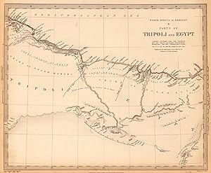
North Africa or Barbary V Parts of Tripoli and Egypt - Published under the Superintendence of the Society for the Diffusion of Useful Knowledge.
Published by Baldwin & Cradock, London, 1837
Seller: Antiquariat Reinhold Berg eK Inh. R.Berg, Regensburg, Germany
Seller rating 5 out of 5 stars
Map
Other. Steel engraving, hand colored in outline when published. This is a very detailed map from North Africa with parts of Tripoli and Egypt. In excellent condition. 320 by 390mm (12� by 15� inches). 320 by 390mm (12� by 15� inches).
-

Condition: very good. Gut/Very good: Buch bzw. Schutzumschlag mit wenigen Gebrauchsspuren an Einband, Schutzumschlag oder Seiten. / Describes a book or dust jacket that does show some signs of wear on either the binding, dust jacket or pages.
-

Condition: very good. Gut/Very good: Buch bzw. Schutzumschlag mit wenigen Gebrauchsspuren an Einband, Schutzumschlag oder Seiten. / Describes a book or dust jacket that does show some signs of wear on either the binding, dust jacket or pages.
-

Condition: good. Befriedigend/Good: Durchschnittlich erhaltenes Buch bzw. Schutzumschlag mit Gebrauchsspuren, aber vollst�ndigen Seiten. / Describes the average WORN book or dust jacket that has all the pages present.
-

Condition: Very good.
-
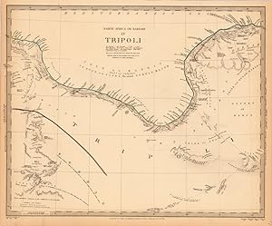
North Africa or Barbary IV Tripoli - Published under the Superintendence of the Society for the Diffusion of Useful Knowledge.
Published by Baldwin & Cradock, London, 1837
Seller: Antiquariat Reinhold Berg eK Inh. R.Berg, Regensburg, Germany
Seller rating 5 out of 5 stars
Map
Other. Steel engraving, hand colored in outline when published. This antique map shows Tripoli in North Africa. Along the coast are many place names engraved. In excellent condition. 318 by 390mm (12� by 15� inches). 318 by 390mm (12� by 15� inches).
-

Ancient Africa or Libya Part I. By Philip Smith Univ. Coll. London. - Published under the Superintendence of the Society for the Diffusion of Useful Knowledge.
Published by Chas. Knight & Co., London, 1837
Seller: Antiquariat Reinhold Berg eK Inh. R.Berg, Regensburg, Germany
Seller rating 5 out of 5 stars
Map
Other. Steel engraving, hand colored in outline when published. This highly detailed map shows the ancient 'North Africa' or Libya. The map is equipped with many details of place names, rivers, mountains, etc. In excellent condition. 318 by 391mm (12� by 15� inches). 318 by 391mm (12� by 15� inches).
-

India X. - Published under the Superintendence of the Society for the Diffusion of Useful Knowledge.
Published by Baldwin & Cradock, London, 1834
Seller: Antiquariat Reinhold Berg eK Inh. R.Berg, Regensburg, Germany
Seller rating 5 out of 5 stars
Map
Other. Steel engraving, hand colored in outline when published. This highly decorative map shows India.The map is equipped with many regions, place names, rivers, mountains, etc. In excellent condition. 263 by 339mm (10 by 13 inches).
-

England III. - Published under the Superintendence of the Society for the Diffusion of Useful Knowledge
Published by Baldwin & Cradock, London, 1830
Seller: Antiquariat Reinhold Berg eK Inh. R.Berg, Regensburg, Germany
Seller rating 5 out of 5 stars
Map
Other. Steel engraving, hand colored in outline when published. This antique map shows England with its Northeastern part. Inside the map are many place names, rivers, etc. engraved. In excellent condition. 265 by 360mm (10� by 14� inches). 265 by 360mm (10� by 14� inches).
-

Indian III Bombay Presidency - Published under the Superintendence of the Society for the Diffusion of Useful Knowledge.
Published by Baldwin & Cradock, London, 1832
Seller: Antiquariat Reinhold Berg eK Inh. R.Berg, Regensburg, Germany
Seller rating 5 out of 5 stars
Map
Other. Steel engraving, hand colored in outline when published. In excellent condition. 263 by 367mm (10 by 14 inches). 263 by 367mm (10 by 14 inches).
-

India VI. - Published under the Superintendence of the Society for the Diffusion of Useful Knowledge.
Published by Baldwin & Cradock, London, 1833
Seller: Antiquariat Reinhold Berg eK Inh. R.Berg, Regensburg, Germany
Seller rating 5 out of 5 stars
Map
Other. Steel engraving, hand colored in outline when published. A very highly decorative map which shows India with many place names, rivers, regions. The explanation of the numbers which are inside the map engraved are at the bottom. In excellent condition. 261 by 357mm (10 by 14 inches). 261 by 357mm (10 by 14 inches).
-

India XI. - Published under the Superintendence of the Society for the Diffusion of Useful Knowledge.
Published by Baldwin & Cradock, London, 1834
Seller: Antiquariat Reinhold Berg eK Inh. R.Berg, Regensburg, Germany
Seller rating 5 out of 5 stars
Map
Other. Steel engraving, hand colored in outline when published. In excellent condition. 263 by 354mm (10 by 14 inches). 263 by 354mm (10 by 14 inches).
-

India IV. - Published under the Superintendence of the Society for the Diffusion of Useful Knowledge.
Published by Baldwin & Cradock, London, 1832
Seller: Antiquariat Reinhold Berg eK Inh. R.Berg, Regensburg, Germany
Seller rating 5 out of 5 stars
Map
Other. Steel engraving, hand colored in outline when published. In excellent condition. 267 by 353mm (10 by 14 inches). 267 by 353mm (10 by 14 inches).