
Order Total (1 Item Items):
Shipping Destination:

Nat Geo (Over 2,200 results)
Author:
nat geo
Refine with Advanced Search
Skip to main search results
Search filters
Product Type
- All Product Types
- Books (2,284)
- Magazines & Periodicals (No further results match this refinement)
- Comics (No further results match this refinement)
- Sheet Music (No further results match this refinement)
- Art, Prints & Posters (No further results match this refinement)
- Photographs (No further results match this refinement)
- Maps (13)
- Manuscripts & Paper Collectibles (No further results match this refinement)
Condition Learn more
- New (2,240)
- As New, Fine or Near Fine (5)
- Very Good or Good (49)
- Fair or Poor (No further results match this refinement)
- As Described (3)
Binding
Collectible Attributes
- First Edition (1)
- Signed (No further results match this refinement)
- Dust Jacket (3)
- Seller-Supplied Images (875)
- Not Print on Demand (2,297)
Language (2)
Free Shipping
Seller Location
Seller Rating
-

National Geographic Kids Nature Almanic
Seller: World of Books (was SecondSale), Montgomery, IL, U.S.A.
Seller rating 5 out of 5 stars

Condition: Good. Item in good condition. Textbooks may not include supplemental items i.e. CDs, access codes etc.
-

Condition: very_good. Book is in very good condition and may include minimal underlining highlighting. The book can also include "From the library of" labels. May not contain miscellaneous items toys, dvds, etc. . We offer 100% money back guarantee and 24 7 customer service.
-
National Geographic Kids Nature Almanic
Seller: Once Upon A Time Books, Siloam Springs, AR, U.S.A.
Seller rating 4 out of 5 stars

paperback. Condition: Very Good.
-
National Geographic Kids Nature Almanic
Language: English
Published by National Geographic Society, 2014
ISBN 10: 1426326408 ISBN 13: 9781426326400
paperback. Condition: New.
-
paperback. Condition: New.
-
Condition: Good. Pages intact with minimal writing/highlighting. The binding may be loose and creased. Dust jackets/supplements are not included. Stock photo provided. Product includes identifying sticker. Better World Books: Buy Books. Do Good.
-
Condition: Very Good. Pages intact with possible writing/highlighting. Binding strong with minor wear. Dust jackets/supplements may not be included. Stock photo provided. Product includes identifying sticker. Better World Books: Buy Books. Do Good.
-
National Geographic Kids Nature Almanic
Seller: Wonder Book, Frederick, MD, U.S.A.
Seller rating 5 out of 5 stars
Condition: As New. Like New condition. A near perfect copy that may have very minor cosmetic defects.
-
National Geographic Kids Nature Almanic
Seller: Wonder Book, Frederick, MD, U.S.A.
Seller rating 5 out of 5 stars
Condition: Very Good. Very Good condition. A copy that may have a few cosmetic defects. May also contain light spine creasing or a few markings such as an owner's name, short gifter's inscription or light stamp.
-
Paperback. Condition: As New. No Jacket. Pages are clean and are not marred by notes or folds of any kind. ~ ThriftBooks: Read More, Spend Less.
-
Paperback. Condition: As New. No Jacket. Pages are clean and are not marred by notes or folds of any kind. ~ ThriftBooks: Read More, Spend Less.
-
paperback. Condition: New. PAP.
-
paperback. Condition: New. Fast Shipping - Safe and Secure Bubble Mailer!
-
National Geographic Kids Nature Almanac
Language: English
Published by National Geographic Society, 2014
ISBN 10: 1426326408 ISBN 13: 9781426326400
Soft Cover. Condition: Very Good. Wraps have only light wear. Pages are clean with no markings in text. Size: 8vo - over 7�" - 9�" tall.
-
National Geographic Kids Animals Almanic
Language: English
Published by National Geographic Society, 2014
ISBN 10: 1426326408 ISBN 13: 9781426326400
Soft Cover. Condition: Very Good. Wraps have only light wear. Pages are clean with no markings in text. Size: 8vo - over 7�" - 9�" tall.
-

Look and Learn: Bears
Book 10 of 23: Look & LearnLanguage: English
Published by National Geographic Kids, US, 2015
ISBN 10: 1426318758 ISBN 13: 9781426318757
Seller: Rarewaves.com USA, London, LONDO, United Kingdom
Seller rating 5 out of 5 stars
Board Book. Condition: New. Welcome to the world of bears! With fun photos and colourful, approachable design, this wonderful board book guides you through life as a bear, including hibernation, playtime with cubs, the smallest and biggest bears, and finding food!
-
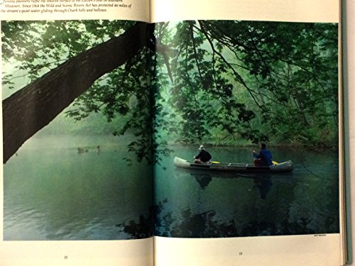
America's Wild And Scenic Rivers
Language: English
Published by National Geographic Society, 1983
ISBN 10: 0870444409 ISBN 13: 9780870444401
Seller: Library House Internet Sales, Grand Rapids, OH, U.S.A.
Seller rating 4 out of 5 stars
Hardcover. Condition: Good. Dust Jacket Condition: Good. The rich endowment of America's wild and scenic rivers are and have been protected since 1983. Piece(s) of the spine missing. Solid binding. Please note the image in this listing is a stock photo and may not match the covers of the actual item. Book.
-

Condition: Very Good. Most items will be dispatched the same or the next working day. A copy that has been read, but is in excellent condition. Pages are intact and not marred by notes or highlighting. The spine remains undamaged.
-

Condition: Very Good. Very Good Condition. Five star seller - Buy with confidence!
-

LOOK AND LEARN BEARS
Book 10 of 23: Look & LearnLanguage: English
Published by National Geographic Kids, 2015
ISBN 10: 1426318758 ISBN 13: 9781426318757
Condition: NEW.
-

Mountain Worlds
Seller: Library House Internet Sales, Grand Rapids, OH, U.S.A.
Seller rating 4 out of 5 stars
Hardcover. Condition: Fine. No Jacket. Examines the mountains of the world and the people who inhabit them. Please note the image in this listing is a stock photo and may not match the covers of the actual item. Book.
-

Maine Map
Language: English
Published by National Geographic Maps, US, 2012
ISBN 10: 1597753149 ISBN 13: 9781597753142
Map. Condition: New. 2024th ed. . Waterproof . Tear-Resistant . Travel MapNational Geographic's Maine Guide Map is designed to meet the needs of travelers with detailed and accurate cartography and loads of helpful information about the state's many points of interest. In addition to a state map, inset maps provide detail of the cities of Portland, Freeport/Yarmouth, Bar Harbor, Bangor, Augusta, and Lewiston-Auburn. Specialty content to include hundreds of diverse and unique recreational, ecological, cultural, and historical destinations, make this map invaluable to travelers hoping to experience all the state has to offer. Maps and information about the Lighthouses of Maine scenic drive and Acadia National Park highlight some of the stunning beauty and unique attractions to be found in the state. A chart of park service sites and climate information will be particularly helpful to travelers taking in the many outdoor activities in Maine. Cities and towns are clearly indicated and easy to find in the user-friendly index. Highways, roadways, toll roads, scenic routes, and other roads are clearly designated. Distances in miles are noted on major highways so travelers can easily plan their best route. National and state parks, public campsites, visitor information centers, airports, ski areas, ports of entry, and hospitals are noted as well.Every State Guide Map is printed on durable synthetic paper, making them waterproof, tear-resistant and tough - capable of withstanding the rigors of any kind of travel.
-

Munich Map
Language: English
Published by National Geographic Maps, US, 2012
ISBN 10: 1597753114 ISBN 13: 9781597753111
Map. Condition: New. . Waterproof . Tear-Resistant . Travel MapNational Geographic's City Destination map of Munich is an invaluable tool for exploring the capital of Bavaria. The comprehensive street map on the front side provides exceptional detail of the city. Points of interest, hotels, places of worship, notable buildings, theaters, parks, information centers, and more are easy to find with the multi-language legend. Transportation aids such as subway and regional railway stations and parking areas are shown as well.Information on various points of interest are included on the reverse side, along with maps of the region and the extravagant palace of Schloss Nymphenburg. The Romantic Road and Bavarian Alps map provides detail of the Romantic, Alpine, Castle and Thuringia, and Alpine-Baltic roads. Handy diagrams of Munich (Franz Josef Strauss) International Airport and the U-Bahn (subway) and S-Bahn (suburban trains) transit systems will help you navigate the city quickly and efficiently.Every Destination Map is printed on durable synthetic paper, making them waterproof, tear-resistant and tough - capable of withstanding the rigors of any kind of travel.
-

Washington D.C. Map
Language: English
Published by National Geographic Maps, US, 2018
ISBN 10: 1566957303 ISBN 13: 9781566957304
Map. Condition: New. 2022nd ed. . Waterproof . Tear-Resistant . Travel MapThe national's capital and home to many of the country's most treasured monuments and museums, Washington D. C. is a popular destination for business and leisure travelers. National Geographic's City Destination map of Washington D. C. is a comprehensive guide to the city, combining an easy-to-read road map with an informative and well researched travel guide. The map covers the city from Georgetown, through the White House, National Mall and Capitol, to the Washington Navy Yard, along with parts of Northern Virginia, the Potomac River and its many bridges.Pinpointed on the map are hundreds of points of interest, including monuments, hotels, places of worship, parks, police stations, hospitals, notable buildings and metro stations. Many of the city's most popular attractions are depicted in 3D, including the Lincoln Memorial, Washington Monument and White House. An inset map outlines the neighboring area of Old Town Alexandria. A comprehensive metro map along with diagrams of Dulles and Reagan National Airports are shown along with background information of the transit system. To assist in your navigation of the area, a user friendly index of streets, government buildings, monuments, museums, parks, hotels and metro stations is also provided.Every Destination Map is printed on durable synthetic paper, making them waterproof, tear-resistant and tough - capable of withstanding the rigors of any kind of travel.
-

Orlando Map
Language: English
Published by National Geographic Maps, US, 2012
ISBN 10: 159775076X ISBN 13: 9781597750769
Map. Condition: New. . Waterproof . Tear-Resistant . Travel MapNational Geographic's City Destination map of Orlando is both a comprehensive map and travel guide for the city for business and leisure travelers alike. The city is presented using various maps with different levels of detail. A road map of the entire state of Florida shows the city's position in the center of the state and a regional map shows the roads leading in a out of the city. A city map of the Orlando area shows the city and its suburbs and inset maps of the Walt Disney Resort, International Drive and Downtown provide unparalleled detail of these popular areas. Pinpointed on the maps are hundreds of hotels, theaters, churches, parks, train stations, churches, notable buildings and points of interest.Each inset map is accompanied by an easy to use index of cities and towns, roads, hotels, attractions, golf courses, parks and other points of interest, which will aid in planning your route and arriving at your destination. A diagram of Orlando Airport will allow you to navigate this travel hub quickly and efficiently. Background information about the city, an overview of the public transit system and descriptions of top attractions in and around the city are also provided. Every Destination Map is printed on durable synthetic paper, making them waterproof, tear-resistant and tough - capable of withstanding the rigors of any kind of travel.
-

Virginia Map
Language: English
Published by National Geographic Maps, US, 2012
ISBN 10: 1597750603 ISBN 13: 9781597750608
Map. Condition: New. 2024th ed. . Waterproof . Tear-Resistant . Travel MapNational Geographic's Virginia Guide Map is an unparalleled and expertly researched guide to the 'Old Dominion.' The main map shows the road network, with clear designations for free access and toll highway; interstate, state and country routes; other paved and unpaved roads; and scenic drives with their waysides stops. Major highways are shown with mileage markers. Pinpointed are hundreds of points of interest, national and state recreation areas, visitor centers, ski areas, hospital and airports. An index of counties, cities and towns will assist in finding your destination quickly. Inset maps cover some of the largest cities and metropolitan areas, including the Washington DC area, Richmond, Charlottesville, Roanoke, Lynchburg, Colonial National Historical Park and Hampton Roads. Visitor information and inset maps are shown for Shenandoah National Park and the Blue Ridge Parkway scenic drive. Other popular points of interest, a chart of national park services and a calendar of events are also provided along with contact details for all listings.Every State Guide Map is printed on durable synthetic paper, making them waterproof, tear-resistant and tough - capable of withstanding the rigors of any kind of travel.
-

New Orleans Map
Language: English
Published by National Geographic Maps, US, 2010
ISBN 10: 1597754145 ISBN 13: 9781597754149
Map. Condition: New. . Waterproof . Tear-Resistant . Travel MapWhether you're seeking the jazz and nightlife of the French Quarter or want to take in the many museums and galleries in the Warehouse/Arts District, National Geographic's City Destination map of New Orleans will help you make the most of your visit. The front side of this map is loaded with information on points of interest in and around New Orleans including a map of Louisiana plantations. A map of the region and a diagram of Louis Armstrong New Orleans International Airport provide additional tools for navigating the area.A detailed street map of the city is shown on the reverse side. Hundreds of points of interest including monuments, parks, theaters, churches, hotels, visitor centers, and more are easy to find with the multi-language legend. Transportation aids such streetcars, shuttles, and ferries will prove invaluable in traversing the city using public transit. Additional services such as police stations, post offices, and hospitals are included as well.Every Destination Map is printed on durable synthetic paper, making them waterproof, tear-resistant and tough - capable of withstanding the rigors of any kind of travel.
-

London Map
Language: English
Published by National Geographic Maps, US, 2018
ISBN 10: 1566957826 ISBN 13: 9781566957823
Map. Condition: New. . Waterproof . Tear-Resistant . Travel MapNational Geographic's City Destination map of London combines a city map and travel guide, making it the ultimate traveling companion to this leading tourism destination. The reverse side presents an easy-to-read road map with hundreds of points of interest including 3D depictions of many top attractions, like the London Eye, Buckingham Palace and the Tower of London. Pinpointed are underground (tube) stops, rail stations, river bus stops, theaters, hotels, places of worship, notable buildings, police stations, hospitals, parks, pedestrian areas and other points of interest. Also displayed is a full map of the London underground. The front side has a regional map and descriptions of the city, many popular attractions and the transit system. A user-friendly index of streets, hotels and points of interest along with diagrams of Heathrow and Gatwick Airports will help you arrive at your destination quickly. An inset map of Hyde Park and Kensington provides details of this very popular area. With all of this specialized content, this map is the perfect complement to National Geographic's London Traveler Guide. Every Destination Map is printed on durable synthetic paper, making them waterproof, tear-resistant and tough - capable of withstanding the rigors of any kind of travel.
-

Las Vegas Map
Language: English
Published by National Geographic Maps, US, 2012
ISBN 10: 1597751928 ISBN 13: 9781597751926
Map. Condition: New. . Waterproof . Tear-Resistant . Travel MapHome to some of the world's best known mega casinos-hotels, Las Vegas is internationally recognized by its unique cityscape along The Strip. Whether traveling to 'Sin City' for business or pleasure, National Geographic's City Destination map of Las Vegas will be an invaluable travel companion, serving both as a comprehensive street map and well-researched travel guide. The map's front side features a regional map and inset maps of the downtown area and Grand Canyon, Bryce Canyon and Zion National Parks. An overview of the transit system along with a diagram of McCarran International Airport will help you get acclimated to the city. Information is also provided about popular attraction in and around the city. The main road map is on the reverse side, detailed with hundreds of points of interest, hotels, notable buildings, parks and theaters, as well as police stations, hospitals and post offices. Many top attractions are displayed in 3D, including the Stratosphere Tower, the Bellagio and MGM Grand. A user friendly index of streets and points of interest, will help you find your destination and plan your route quickly and efficiently. Every Destination Map is printed on durable synthetic paper, making them waterproof, tear-resistant and tough - capable of withstanding the rigors of any kind of travel.
-

Oregon Map
Language: English
Published by National Geographic Maps, US, 2018
ISBN 10: 1566957753 ISBN 13: 9781566957755
Map. Condition: New. . Waterproof . Tear-Resistant . Travel MapExpertly researched and full of high functional travel information, National Geographic's Oregon Guide Map combines a comprehensive road map and a travel guide in one easy to use resource. Roads are clearly designated as toll roads, highways, major and secondary routes, and scenic byways. The road network in annotated with mileage markers and points of interest, such as national and state parks, national forests, campgrounds, ski areas, airports, visitor information centers, hospitals and much more. Inset maps of Eugene, Salem, Portland and its downtown provide extra detail to these popular areas in the state. Crater National Park, Columbia River Gorge and Rogue Umpqua Scenic Byway are given special coverage including both maps and descriptions. A calendar of events, chart of park service sites and an overview of points of interest along with contact information will help you plan your visit. An index of cities, towns and counties along with a chart of driving distances will aid in your finding your destination and planning your route. Every State Guide Map is printed on durable synthetic paper, making them waterproof, tear-resistant and tough - capable of withstanding the rigors of any kind of travel.