
Order Total (1 Item Items):
Shipping Destination:

Johnso a J Compiled Drawn (50 results)
Skip to main search results
Search filters
Product Type
- All Product Types
- Books (1)
- Magazines & Periodicals (No further results match this refinement)
- Comics (No further results match this refinement)
- Sheet Music (No further results match this refinement)
- Art, Prints & Posters (49)
- Photographs (No further results match this refinement)
- Maps (No further results match this refinement)
- Manuscripts & Paper Collectibles (No further results match this refinement)
Condition Learn more
- New (No further results match this refinement)
- As New, Fine or Near Fine (No further results match this refinement)
- Very Good or Good (50)
- Fair or Poor (No further results match this refinement)
- As Described (No further results match this refinement)
Binding
- All Bindings
- Hardcover (No further results match this refinement)
- Softcover (50)
Collectible Attributes
- First Edition (50)
- Signed (No further results match this refinement)
- Dust Jacket (No further results match this refinement)
- Seller-Supplied Images (47)
- Not Print on Demand (50)
Language (1)
Free Shipping
- Free Shipping to U.S.A. (No further results match this refinement)
Seller Location
Seller Rating
-

MAP: "Johnson's Map of Iowa & Nebraska (1861)'.from Johnson's New Illustrated (Steel Plate) Family Atlas, 1861
Published by Johnson & Browning, Richmond, VA, 1861
Seller: Dorley House Books, Inc., Hagerstown, MD, U.S.A.
Seller rating 4 out of 5 stars

Art / Print / Poster First Edition
Unbound. Condition: Very Good. Handcolored Map (illustrator). 1st. Plate #50; lovely hand-colored map; of Iowa & Nebraska at the beginning of the Civil War, decorative strapwork border; w/ Counties, cities, roads, rivers, railroads, wagon roads,canals, ports, etc & w/ insect engraving; some insect damage at border as shown Size: 17" x 13.5".
-

MAP: "Johnson's Map of the World on Mercator's Projection'.from Johnson's New Illustrated (Steel Plate) Family Atlas, 1861
Published by Johnson & Browning, Richmond, VA, 1861
Seller: Dorley House Books, Inc., Hagerstown, MD, U.S.A.
Seller rating 4 out of 5 stars
Art / Print / Poster First Edition
Unbound. Condition: Very Good. Handcolored (illustrator). 1st. Plate #6,7: lovely double page map of the mid 19th century world, including major sea routes of explorers (Captain Cook, captain Wilkes); comparative distances, etc. Priced here to reflect the repaired closed tear at the lower edge. Size: 17 x 24.5 Inches.
-

MAP: "A Diagram Exhibiting the Difference of Time Between the Places Shown & Washington (1861)'.from Johnson's New Illustrated (Steel Plate) Family Atlas, 1861
Published by Johnson & Browning, Richmond, VA, 1861
Seller: Dorley House Books, Inc., Hagerstown, MD, U.S.A.
Seller rating 4 out of 5 stars
First Edition
Unbound. Condition: Very Good. Hand Colored Map (illustrator). 1st. Plate #8: lovely diagram, Washington, D.C. at the center with figures positioned on the dial denoting air line distances from the nation's Capital Size: 17 x 13 Inches.
-

MAP: "Johnson's Map of Maine (1861)'.from Johnson's New Illustrated (Steel Plate) Family Atlas, 1861
Published by Johnson & Browning, Richmond, VA, 1861
Seller: Dorley House Books, Inc., Hagerstown, MD, U.S.A.
Seller rating 4 out of 5 stars
Art / Print / Poster First Edition
Unbound. Condition: Very Good. Handcolored Map (illustrator). 1st. Plate #22: lovely full page hand-colored map; mid-19th century, decorative strapwork style border. of the state of Maine,w/ railroads, canals, common roads, cities, towns, and villages in the mid-19th century. S Size: 17 x 13 Inches.
-

MAP: "Johnson's Map of New Hampshire & Vermont (1861)'.from Johnson's New Illustrated (Steel Plate) Family Atlas, 1861
Published by Johnson & Browning, Richmond, VA, 1861
Seller: Dorley House Books, Inc., Hagerstown, MD, U.S.A.
Seller rating 4 out of 5 stars
Art / Print / Poster First Edition
Unbound. Condition: Very Good. Handcolored Map (illustrator). 1st. Plate #23, 24: lovely double page hand-colored map; mid-19th century, decorative strapwGreen Mountains indicated, , railroads and canals as well. Lower right quadrant goes beyond the bordering as shown. Size: 17 x 24.5 Inches.
-

MAP: "Johnson's Map of CUBA, Jamaica & Puerto Rico (1861)'.from Johnson's New Illustrated (Steel Plate) Family Atlas, 1861
Published by Johnson & Browning, Richmond, VA, 1861
Seller: Dorley House Books, Inc., Hagerstown, MD, U.S.A.
Seller rating 4 out of 5 stars
Art / Print / Poster First Edition
Unbound. Condition: Very Good. Handcolored Illustrations (illustrator). 1st. Plate #58; lovely hand-colored map; of CUBA, Jamaica & Puerto Rico at the beginning of the Civil War, decorative strapwork border; w/ Counties, cities, roads, rivers, railroads, wagon roads,canals, ports, etc w/insets of Porto rico, city and haror of Havana, Grand Cayman Size: 17" x 13.5".
-

MAP: "Johnson's Map of Mexico (1861)'.from Johnson's New Illustrated (Steel Plate) Family Atlas, 1861
Published by Johnson & Browning, Richmond, VA, 1861
Seller: Dorley House Books, Inc., Hagerstown, MD, U.S.A.
Seller rating 4 out of 5 stars
Art / Print / Poster First Edition
Unbound. Condition: Very Good. Handcolored Illustrations (illustrator). 1st. Plate #56; lovely hand-colored map; of Mexico at the beginning of the Civil War, decorative strapwork border; w/ Counties, cities, roads, rivers, railroads, wagon roads,canals, ports, etc w/inset of Tehuamtepec Size: 17" x 13.5".
-

MAP: "Johnson's Map of ASIA (1861)'.from Johnson's New Illustrated (Steel Plate) Family Atlas, 1861
Published by Johnson & Browning, Richmond, VA, 1861
Seller: Dorley House Books, Inc., Hagerstown, MD, U.S.A.
Seller rating 4 out of 5 stars
Art / Print / Poster First Edition
Unbound. Condition: Very Good. Handcolored Map (illustrator). 1st. Plate #82; lovely hand-colored map; of ASIA at the beginning of the US Civil War, decorative strapwork border; w/ Counties, cities, roads, rivers, railroads, wagon roads,canals, ports, etc Size: 17" x 13.5".
-

MAP: "Johnson's Map of Central America (1861)'.from Johnson's New Illustrated (Steel Plate) Family Atlas, 1861
Published by Johnson & Browning, Richmond, VA, 1861
Seller: Dorley House Books, Inc., Hagerstown, MD, U.S.A.
Seller rating 4 out of 5 stars
Art / Print / Poster First Edition
Unbound. Condition: Very Good. Handcolored Illustrations (illustrator). 1st. Plate #57; lovely hand-colored map; of Mexico at the beginning of the Civil War, decorative strapwork border; w/ Counties, cities, roads, rivers, railroads, wagon roads,canals, ports, etc w/insets of ;Isthmus of Panama; the Niacarague Route, the Ccity of Panama; Aspinwall City & Navy Bay. Size: 17" x 13.5".
-

MAP: "Johnson's Map of Brazil, Argentne Republic, Paraguay & Uraguay (1861)'.from Johnson's New Illustrated (Steel Plate) Family Atlas, 1861
Published by Johnson & Browning, Richmond, VA, 1861
Seller: Dorley House Books, Inc., Hagerstown, MD, U.S.A.
Seller rating 4 out of 5 stars
Art / Print / Poster First Edition
Unbound. Condition: Very Good. Handcolored Illustrations (illustrator). 1st. Plate #62 lovely hand-colored map; of Brazil, Argentne Republic, Paraguay & Uraguay at the beginning of the Civil War, decorative strapwork border; w/ Counties, cities, roads, rivers, railroads, wagon roads,canals, ports, etc w/insets Rio de janeiro & pernambuco; and 1 engravings Size: 17" x 13.5".
-

MAP: "Mountains and Rivers'.from Johnson's New Illustrated (Steel Plate) Family Atlas, 1861
Published by Johnson & Browning, Richmond, VA, 1861
Seller: Dorley House Books, Inc., Hagerstown, MD, U.S.A.
Seller rating 4 out of 5 stars
Art / Print / Poster First Edition
Unbound. Condition: Very Good. handcolored Plates (illustrator). 1st. Plate #1,2: lovely double page map (scattered foxing) with comparative distances and heights of the world's most famous mountains and rivers, Size: 17 x 24.5 Inches.
-
MAP: "Western Hemisphere/ Eastern Hemisphere".from Johnson's New Illustrated (Steel Plate) Family Atlas, 1861
Published by Johnson & Browning, Richmond, VA, 1861
Seller: Dorley House Books, Inc., Hagerstown, MD, U.S.A.
Seller rating 4 out of 5 stars
Art / Print / Poster First Edition
Unbound. Condition: Very Good. Handcolored Map (illustrator). 1st. Plate #4,5: lovely double page map (lite toning) ; hemispheric projections of the world in the mid 19th century Size: 17 x 24.5 Inches.
-
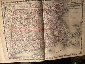
MAP: "Johnson's Map of Massachusetts, Connecticut, Rhode Island (1861)'.from Johnson's New Illustrated (Steel Plate) Family Atlas, 1861
Published by Johnson & Browning, Richmond, VA, 1861
Seller: Dorley House Books, Inc., Hagerstown, MD, U.S.A.
Seller rating 4 out of 5 stars
Art / Print / Poster First Edition
Unbound. Condition: Very Good. Handcolored Map (illustrator). 1st. Plate #25,26: lovely double page hand-colored map; of three states as well as Long Island Soumd ports, the Massachusetts Islands Cape Cod, etc . as in mid-19th century, decorative strapwork border; and indicated counties, townships, railroads, towns, roads, railroads, etc. small marginal repair at lower edge Size: 17 x 24.5 Inches.
-

MAP: "Johnson's Map of Austria, Turkey in Europe & Greece (1861)'.from Johnson's New Illustrated (Steel Plate) Family Atlas, 1861
Published by Johnson & Browning, Richmond, VA, 1861
Seller: Dorley House Books, Inc., Hagerstown, MD, U.S.A.
Seller rating 4 out of 5 stars
Art / Print / Poster First Edition
Unbound. Condition: Very Good. Handcolored Map (illustrator). 1st. Plate #80, 81; lovely double page hand-colored map; of Austria, Turkey in Europe & Greece at the beginning of the US Civil War, decorative strapwork border; w/ Counties, cities, roads, rivers, railroads, wagon roads,canals, ports, etc. w/ inset of Candia and an engravig Size: 17" x 24.5".
-

MAP: "Johnson's Map of Hindostan or British India (1861)'.from Johnson's New Illustrated (Steel Plate) Family Atlas, 1861
Published by Johnson & Browning, Richmond, VA, 1861
Seller: Dorley House Books, Inc., Hagerstown, MD, U.S.A.
Seller rating 4 out of 5 stars
Art / Print / Poster First Edition
Unbound. Condition: Very Good. Handcolored Map (illustrator). 1st. Plate #85; lovely hand-colored map; of Hindostan or British India at the beginning of the US Civil War, decorative strapwork border; w/ Counties, cities, roads, rivers, railroads, wagon roads,canals, ports, etc. w/insets of Madras & Calcutta & Bombay and an engravig Size: 17" x 13.5".
-

MAP: "Johnson's Map of Switzerland(1861)'.from Johnson's New Illustrated (Steel Plate) Family Atlas, 1861
Published by Johnson & Browning, Richmond, VA, 1861
Seller: Dorley House Books, Inc., Hagerstown, MD, U.S.A.
Seller rating 4 out of 5 stars
Art / Print / Poster First Edition
Unbound. Condition: Very Good. Handcolored Map (illustrator). 1st. Plate #74; lovely hand-colored map; of Switzerland( at the beginning of the US Civil War, decorative strapwork border; w/ Counties, cities, roads, rivers, railroads, wagon roads,canals, ports, etc & with an inset od Hamburg & Bremen Size: 17" x 13.5".
-

MAP: "Johnson's Map of Africa (1861)'.from Johnson's New Illustrated (Steel Plate) Family Atlas, 1861
Published by Johnson & Browning, Richmond, VA, 1861
Seller: Dorley House Books, Inc., Hagerstown, MD, U.S.A.
Seller rating 4 out of 5 stars
Art / Print / Poster First Edition
Unbound. Condition: Very Good. Handcolored Map (illustrator). 1st. Plate #89, 90; lovely double page hand-colored map; of Africa at the beginning of the US Civil War, decorative strapwork border; w/ Counties, cities, roads, rivers, railroads, wagon roads,canals, ports, etc. w/ inset St. Helena and 2 engravings Size: 17" x 24.5".
-

MAP: "Johnson's Map of Holland & Belgium (1861)'.from Johnson's New Illustrated (Steel Plate) Family Atlas, 1861
Published by Johnson & Browning, Richmond, VA, 1861
Seller: Dorley House Books, Inc., Hagerstown, MD, U.S.A.
Seller rating 4 out of 5 stars
Art / Print / Poster First Edition
Unbound. Condition: Very Good. Handcolored Map (illustrator). 1st. Plate #69, 70; lovely double page hand-colored map; of Holland & Belgium at the beginning of the US Civil War, decorative strapwork border; w/ Counties, cities, roads, rivers, railroads, wagon roads,canals, ports, etc & with an inset of Corsicca, Amsterdan & Brussels Size: 17" x 24.5".
-

MAP: "Johnson's Map of AUSTRALIA (1861)'.from Johnson's New Illustrated (Steel Plate) Family Atlas, 1861
Published by Johnson & Browning, Richmond, VA, 1861
Seller: Dorley House Books, Inc., Hagerstown, MD, U.S.A.
Seller rating 4 out of 5 stars
Art / Print / Poster First Edition
Unbound. Condition: Very Good. Handcolored Map (illustrator). 1st. Plate #88; lovely hand-colored map; of AUSTRALIA at the beginning of the US Civil War, decorative strapwork border; w/ Counties, cities, roads, rivers, railroads, wagon roads,canals, ports, etc. w/insets of Yesso & Nagasaki Size: 17" x 13.5".
-

MAP: "Johnson's Map of England & Wales (1861)'.from Johnson's New Illustrated (Steel Plate) Family Atlas, 1861
Published by Johnson & Browning, Richmond, VA, 1861
Seller: Dorley House Books, Inc., Hagerstown, MD, U.S.A.
Seller rating 4 out of 5 stars
Art / Print / Poster First Edition
Unbound. Condition: Very Good. Handcolored Map (illustrator). 1st. Plate #65,66; lovely double page hand-colored map; of England & Wales at the beginning of the US Civil War, decorative strapwork border; w/ Counties, cities, roads, rivers, railroads, wagon roads,canals, ports, etc & with an inset of Scilly Isles Size: 17" x 24.5".
-
MAP: "Johnson's Map of Ireland & Scotland (1861)'.from Johnson's New Illustrated (Steel Plate) Family Atlas, 1861
Published by Johnson & Browning, Richmond, VA, 1861
Seller: Dorley House Books, Inc., Hagerstown, MD, U.S.A.
Seller rating 4 out of 5 stars
Art / Print / Poster First Edition
Unbound. Condition: Very Good. Handcolored Map (illustrator). 1st. Plate #67, 68; lovely double page hand-colored map; of Ireland & Scotland at the beginning of the US Civil War, decorative strapwork border; w/ Counties, cities, roads, rivers, railroads, wagon roads,canals, ports, etc & with an inset of the Shetland Isles & the Orkney Isles Size: 17" x 24.5".
-

MAP: "Johnson's Map of SOUTH AMERICA (1861)'.from Johnson's New Illustrated (Steel Plate) Family Atlas, 1861
Published by Johnson & Browning, Richmond, VA, 1861
Seller: Dorley House Books, Inc., Hagerstown, MD, U.S.A.
Seller rating 4 out of 5 stars
Art / Print / Poster First Edition
Unbound. Condition: Very Good. Handcolored Map (illustrator). 1st. Plate #54,55; lovely double page hand-colored map; of SOUTH AMERICA at the beginning of the Civil War, decorative strapwork border; w/ Counties, cities, roads, rivers, railroads, wagon roads,canals, ports, etc & w/ inset engraving Size: 17" x 24.5".
-

MAP: "Johnson's Map of Spain & Portugal (1861)'.from Johnson's New Illustrated (Steel Plate) Family Atlas, 1861
Published by Johnson & Browning, Richmond, VA, 1861
Seller: Dorley House Books, Inc., Hagerstown, MD, U.S.A.
Seller rating 4 out of 5 stars
Art / Print / Poster First Edition
Unbound. Condition: Very Good. Handcolored Map (illustrator). 1st. Plate #71; lovely hand-colored map; of Spain & Portugal at the beginning of the US Civil War, decorative strapwork border; w/ Counties, cities, roads, rivers, railroads, wagon roads,canals, ports, etc & with an inset o Gilbraltar Size: 17" x 13.5".
-

MAP: "Johnson's Map of Germany No. 2 & No.3 (1861)'.from Johnson's New Illustrated (Steel Plate) Family Atlas, 1861
Published by Johnson & Browning, Richmond, VA, 1861
Seller: Dorley House Books, Inc., Hagerstown, MD, U.S.A.
Seller rating 4 out of 5 stars
Art / Print / Poster First Edition
Unbound. Condition: Very Good. Handcolored Map (illustrator). 1st. Plate #775, 76; lovely double page hand-colored map; of Germany No. 2 & No. 3 at the beginning of the US Civil War, decorative strapwork border; w/ Counties, cities, roads, rivers, railroads, wagon roads,canals, ports, etc Size: 17" x 24.5".
-

MAP: "Johnson's Map of Northern & Southern ITALY (1861)'.from Johnson's New Illustrated (Steel Plate) Family Atlas, 1861
Published by Johnson & Browning, Richmond, VA, 1861
Seller: Dorley House Books, Inc., Hagerstown, MD, U.S.A.
Seller rating 4 out of 5 stars
Art / Print / Poster First Edition
Unbound. Condition: Very Good. Handcolored Map (illustrator). 1st. Plate #78, 79; lovely double page hand-colored map; of Northern & Southern ITALY at the beginning of the US Civil War, decorative strapwork border; w/ Counties, cities, roads, rivers, railroads, wagon roads,canals, ports, etc. w/ inset of Malta Size: 17" x 24.5".
-

MAP: "Johnson's Map of Prussia, Norway, Sweden & Denmark (1861)'.from Johnson's New Illustrated (Steel Plate) Family Atlas, 1861
Published by Johnson & Browning, Richmond, VA, 1861
Seller: Dorley House Books, Inc., Hagerstown, MD, U.S.A.
Seller rating 4 out of 5 stars
Art / Print / Poster First Edition
Unbound. Condition: Very Good. Handcolored Map (illustrator). 1st. Plate #72, 73; lovely double page hand-colored map; of Prussia, Norway, Sweden & Denmark at the beginning of the US Civil War, decorative strapwork border; w/ Counties, cities, roads, rivers, railroads, wagon roads,canals, ports, etc & with 2 engravings Size: 17" x 24.5".
-

MAP: "Johnson's Map of Minnseota & Dakota (Territory) (1861)'.from Johnson's New Illustrated (Steel Plate) Family Atlas, 1861
Published by Johnson & Browning, Richmond, VA, 1861
Seller: Dorley House Books, Inc., Hagerstown, MD, U.S.A.
Seller rating 4 out of 5 stars
Art / Print / Poster First Edition
Unbound. Condition: Very Good. Handcolored Illustrations (illustrator). 1st. Plate #52; lovely hand-colored map; of Minnseota & Dakota at the beginning of the Civil War, decorative strapwork border; w/ Counties, cities, roads, rivers, railroads, wagon roads,canals, ports, etc Size: 17" x 13.5".
-

MAP: "Johnson's Map of the Roman Empire, Imperium Roanorum Latissie Patens (1861)'.from Johnson's New Illustrated (Steel Plate) Family Atlas, 1861
Published by Johnson & Browning, Richmond, VA, 1861
Seller: Dorley House Books, Inc., Hagerstown, MD, U.S.A.
Seller rating 4 out of 5 stars
Art / Print / Poster First Edition
Unbound. Condition: Very Good. Handcolored Map (illustrator). 1st. Plate #91, 92; lovely double page hand-colored map; of the Roman Empire . decorative strapwork border; w/ Counties, cities, roads, rivers, railroads, wagon roads,canals, ports, etc. w/ inset St. Helena and 2 engravings Size: 17" x 24.5".
-

MAP: "Johnson's Map of JAPAN, Nippon, Kiusui, Siskok, Yesso and the Japanese Kuriles (1861)'.from Johnson's New Illustrated (Steel Plate) Family Atlas, 1861
Published by Johnson & Browning, Richmond, VA, 1861
Seller: Dorley House Books, Inc., Hagerstown, MD, U.S.A.
Seller rating 4 out of 5 stars
Art / Print / Poster First Edition
Unbound. Condition: Very Good. Handcolored Map (illustrator). 1st. Plate #86; lovely hand-colored map; of JAPAN, Nippon, Kiusui, Siskok, Yesso and the Japanese Kuriles at the beginning of the US Civil War, decorative strapwork border; w/ Counties, cities, roads, rivers, railroads, wagon roads,canals, ports, etc. w/insets of Yesso & Nagasaki Size: 17" x 13.5".
-

MAP: "Johnson's Map of Europe (1861)'.from Johnson's New Illustrated (Steel Plate) Family Atlas, 1861
Published by Johnson & Browning, Richmond, VA, 1861
Seller: Dorley House Books, Inc., Hagerstown, MD, U.S.A.
Seller rating 4 out of 5 stars
Art / Print / Poster First Edition
Unbound. Condition: Very Good. Handcolored Map (illustrator). 1st. Plate #63,64; lovely double page hand-colored map; of Europe at the beginning of the Civil War, decorative strapwork border; w/ Counties, cities, roads, rivers, railroads, wagon roads,canals, ports, etc & Size: 17" x 24.5".
