
Order Total (1 Item Items):
Shipping Destination:

Bombay Map (8 results)
Skip to main search results
Search filters
Product Type
- All Product Types
- Books (4)
- Magazines & Periodicals (1)
- Comics (No further results match this refinement)
- Sheet Music (No further results match this refinement)
- Art, Prints & Posters (No further results match this refinement)
- Photographs (No further results match this refinement)
- Maps (3)
- Manuscripts & Paper Collectibles (No further results match this refinement)
Condition Learn more
- New (No further results match this refinement)
- As New, Fine or Near Fine (No further results match this refinement)
- Very Good or Good (4)
- Fair or Poor (No further results match this refinement)
- As Described (4)
Binding
Collectible Attributes
Language (2)
Free Shipping
- Free Shipping to U.S.A. (No further results match this refinement)
Seller Location
Seller Rating
-

Where the Buffalo Roam
Language: English
Published by Grove Weidenfeld, New York, 1992
Seller: J J Basset Books, bassettbooks, bookfarm.co.uk, Peter Tavy, United Kingdom
Seller rating 2 out of 5 stars

Grey/Black Cloth. Condition: Very Good. Dust Jacket Condition: Very Good. Map By Arnold Bombay (illustrator). First Edition 10th Impression. Please email for further details Size: 8vo - over 7�" - 9�". Not Signed or Inscribed.
-
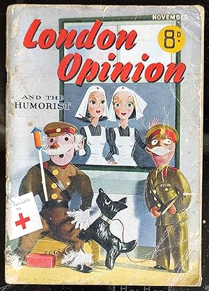
London Opinion and the Humorist. Magazine November 1940
Published by George Newnes Limited, 1940
Magazine / Periodical
Soft cover. Condition: Good. 96 pages. Lynn Dacre "Off The Map" / George Maracco "Fur Coat, Fat Lady" / D Compton-James "Dear Mother." /V C Sayers "The Bogwick Vendetta" / Tallow "The Colonel Whose Feet Were Cold" / Walter Foster "The Mugg's Ruby" / C A Bromley "Another Secret Weapon?" / Geoffrey Palmer "Four Men And A Dictator" / Ivor Waters "The Whitewash King" / S John Peskett "The Strange D Evans "Reunion In Bombay" / Drama Of Cyrus A Clamm" / Aubrey Evans "Reunion In Bombay" / Dan McCourt "Hawkshaw's Night Out" / Denis Dunn "Strained Relation" / John Green well "'On Second Thoughts'" (SL#48).
-
Last Train to Toronto; A Canadian Rail Odyssey
Published by Henry Holt and Company, New York, 1992
Seller: Ground Zero Books, Ltd., Silver Spring, MD, U.S.A.
Seller rating 5 out of 5 stars

First Edition
Hardcover. Condition: Very good. Dust Jacket Condition: Very good. Arnold Bombay (Map), Grant Faint (Jacket photograp (illustrator). xii, [4], 380, [4] pages. Map. Selected Bibliography. Index. DJ has slight wear and soiling. Terry Pindell is an American travel writer known primarily for three North American 'rail odysseys', through the USA, Canada and Mexico, each of which became the subject of a travel book. He has also written a book on migration within the United States. The Toledo Blade said of his first book, Making Tracks: "Not since John Steinbeck's Travels with Charley has anyone put together a better story about America on the road." He is the grandson of a railroad engineer. Derived from a Kirkus review: Pindell rides ``the steel of Canada'' for a year. To Canada, railways have had an importance far beyond transportation needs. Pindell describes the role that trains and tracks have played in Canadian history. But he is also set on a little pulse-taking, so he talks to his fellow passengers who tell him about their lives, their politics, and their views on the US. Pindell begins with a trip from Toronto to Winnipeg on the Canadian. He ends a year later with the Canadian's last run from Vancouver to Toronto--a victim of cutbacks. In between, Pindell travels northwest as far as Prince Rupert; to Gaspe, where the people are predominantly French; to Churchill, where polar bears gather to hunt seals--and to wherever else all the other lines that still carry passengers over the Rockies and through the Maritimes take him. A sturdy piece of travel writing: readable, informative, and a railway buff's delight. First Edition [Stated], First Printing [Stated].
-
Madras Presidency and Bombay Presidency - an Antique Map
Language: English
Publication Date: 1860
Seller: K Books Ltd ABA ILAB, York, YORKS, United Kingdom
Association Member: ABA ILAB PBFA
Seller rating 5 out of 5 stars
No Binding. Condition: Very Good. A splendid original antique map mounted (matted) and ready to frame - mount size 15 x 12 inches, 45 x 36 cms. Excellent condition. Shows the Madras and Bombay Presidencies - 2 maps - mounted together circa 1860.
-
Seeing Bombay of Yesterday, Today and Tomorrow Made Easy Through This Map Guide.
Published by Tej Bros. Map Publications. No date. (Circa1960)., Bombay., 1960
Seller: Asia Bookroom ANZAAB/ILAB, Canberra, ACT, Australia
Association Member: ANZAAB ILAB
Seller rating 5 out of 5 stars
Folding colour pictorial street map, 54.5 x 28cm. Pictorial paper wrappers neatly re-enforced on the spine, folds down to 14 x 10.5cm. Loosely inserted is a price list [8] of Tej Bros. Map Publications with a central staple, illustrated with a Part Plan of Poona and advertisements. Very good condition. A vintage concise guide to Bombay with information on its history, facts and figures, and important travel resources for the tourist. Features folding pictorial street map: "Bombay", with lettered guide to Important Places, scale 1 inch equals 1 mile.
-

Plan De Bombay et de Ses Environs.
Publication Date: 1757
Seller: Geographicus Rare Antique Maps, Brooklyn, NY, U.S.A.
Association Member: ABAA ESA ILAB
Seller rating 4 out of 5 stars

Map
Very good. Light wear along original fold lines. Size 7.75 x 10.5 Inches. This is a beautifully hand-colored c. 1757 Jacques Nicolas Bellin map of Bombay (Mumbai), India. Bellin's map illustrates Bombay as it was becoming the British East India Company's primary base of operations in India, replacing Surat to the north. A Closer Look The map is oriented towards the east, with north at left. The seven main islands of Bombay are illustrated and labeled, along with portions of the mainland coast. The British trading post and fort, at the site of an earlier Portuguese fort, are indicated at the southern end of Bombay Island. A Jesuit mission appears at left, while several structures and a town appear on Salsette Island, retained by the Portuguese after the islands to the south were turned over to the British and then ceded to the Maratha Confederacy. Soundings, anchorages, shoals, and hazards appear in the bay as navigation aids. Historical Context Bombay was at this time under lease to the East India Company from the British Crown, who had acquired the islands from Portugal as part of the marriage agreement between Charles II and Princess Catherine of Braganza. With easy access to the Persian Gulf - Indian Ocean trade route, Bombay quickly became a busy harbor town and an important center for British commerce. More broadly, India was undergoing important transitions at this time that would eventually open the door to British dominance on the subcontinent. Namely, the Mughals were largely displaced by the Marathas and Sikhs, who were the most powerful opponents of later British expansion. Thornton's Map Despite being a center of trade, early maps of Bombay are surprisingly scarce. For this map, Bellin had to use the late 17th-century map of Samuel Thornton. Thornton's map is the earliest known printed map of Bombay and is today, for all intents and purposes, unobtainable (a 1711 printing of Thornton's map was previously sold by us). All subsequent maps of Bombay until the late 18th century were based exclusively on the Thornton map. Bellin's small map, here, is no exception, and Thornton's work can be seen in its general layout as well as in the soundings, anchorages, and annotations. Publication History and Census This map was drawn by Jacques Nicolas Bellin and published as plate No. 1 in Vol. 9 of the Abb� Provost's L'Histoire G�n�rale des Voyages . As the map is undated and Provost's book was published in multiple editions from the mid-late 18th century, it is difficult to know its date with certainty, but it closely resembles other editions that have been dated to the mid-18th century (later editions rotated the map to align on a north-south axis).
-

Carte d'Une Partie des Cotes de L'Inde, depuis Bombay jus'qu'a Surate, avec le detail des Habitations de cette Cote.
Publication Date: 1782
Seller: Geographicus Rare Antique Maps, Brooklyn, NY, U.S.A.
Association Member: ABAA ESA ILAB
Seller rating 4 out of 5 stars
Map Signed
Excellent. Size 10.5 x 16.75 Inches. This is a 1782 Pierre-Marie-Fran�ois P�ges map of Bombay, India, and its vicinity. Produced near the end of the First Anglo-Maratha War, this map is uncommon in that it details not just the British fortification on Bombay Island, but also the surrounding Gujarat countryside and communities. A Closer Look Oriented to the east, coverage embraces from the fortified Gujarati city of Surat to the British Fort George on Bombay Island. Several Gujarati villages to the north and east of Bombay are noted. There are a few depth soundings marking approaches to Fort George. On Salcet (Salsette), the cartographer notes and partially illustrates a ruined monument marking the farthest point of Alexander the Great's conquests. We have found no other references to this monument. Historical Context This map was published when First Anglo-Maratha War (1775-1782) was culminating. The conflict was as much a battle within the British East India Company (EIC) as between it and the Marathas. Although nominally vassals of the Mughals, the Maratha Confederacy or Maratha Empire had largely displaced the Mughals in central India and dominated what remained of the once-great empire. Thus, as British interest and influence expanded on the Indian subcontinent in the 18th century, it was in tandem with the rise of the Marathas, whom they eyed warily. Most importantly, the EIC wanted to prevent the Marathas from allying with the French, with whom they were competing for influence in India, quite successfully after sidelining them in the Battle of Plassey in 1757. In the mid-1770s, the EIC in Bombay brazenly intervened in a succession struggle among the Marathas, backing Raghunathrao to succeed as Peshwa (Prime Minister) and signing with him the Treaty of Surat in 1775, which granted the EIC the island of Salsette and the fort of Bassein or Vasai (here as Ba�ain). However, the Bombay Presidency had not cleared this action with the Calcutta Council to which it was subordinate. This dispute within the EIC was set against the backdrop of greater efforts by the British Parliament to control the fantastically wealthy, powerful, and corrupt company, codified in the Regulating Act of 1773 (which subordinated Bombay to Calcutta) and the appointment of the hard-nosed, austere, Indophile Warren Hastings as Governor-General. Therefore, in 1776, almost a year to the day after the Treaty of Surat, the EIC in Calcutta annulled that treaty and signed the Treaty of Purandhar with the Marathas. However, the Bombay Presidency refused to recognize this new treaty and gave refuge to Raghunathrao. This action led the Marathas to actually seek an alliance with the French, which raised British hackles across the board, especially given the tumultuous state of their colonies in North America, an important market for EIC tea and other goods. Although the alliance did not materialize, the Maratha attempt to grant the French a port on the west coast of India led the EIC in Bombay to launch an attack on the Marathas and try to install Raghunathrao as Peshwa. But this went horribly wrong, and the British force (which was, in fact, mostly composed of Indian sepoys) was forced to surrender at the Battle of Wadgaon in January 1779. Afterwards, Hastings assembled reinforcements and sent them to Bombay to regain control of the situation, against the Marathas and his own wayward subordinates. After two years of inconclusive, see-sawing fighting, Hastings and the Marathas signed the Treaty of Salbai with Maratha commander Mahadaji Shinde, which mostly restored the status quo ante (though giving the British Salsette), committed the Marathas to fighting Mysore (which was nominally aligned with the Marathas but had battled both them and the EIC in the recent past), and dispelled any talks of a Maratha-French alliance or French outposts in Maratha territory. Superficially, this treaty was a confirmation of Maratha power and suited both sides, as they did not g.
-
![Seller image for [Bombay]. for sale by Geographicus Rare Antique Maps](https://pictures.abebooks.com/inventory/md/md32068509455.jpg)
[Bombay].
Publication Date: 1673
Seller: Geographicus Rare Antique Maps, Brooklyn, NY, U.S.A.
Association Member: ABAA ESA ILAB
Seller rating 3 out of 5 stars

Map
Good. Pastedown key at bottom center. Some foxing. Full margins. Size with margins is 12 x 8 in. Size 10.5 x 6.5 Inches. This is the rare c. 1673 John Fryer map of Mumbai, India, considered the first published map of Bombay. Fryer's map of Bombay has been criticized as 'incomplete and inaccurate,' but it nonetheless served as the basis of all subsequent maps of Bombay until the William Nicholson surveys of 1768. Seven Islands Becoming One When Fryer visited Bombay in 1673, it consisted of several islands surrounding a low salt flat. The British were actively engaged in landfill projects intended to make the islands a single large, more self-contained, and defensible land mass. None of this work is indicated here, and the only sign of inland water is the presence of 'Salt Ponds.' Fryer's work can thus be understood as not only the first printed map of Bombay to reach the British public but also the first printed iteration of the British vision of what Bombay might become. A Closer Look Oriented to the north, this map covers Sallset Island (Canora), Bombay Island, the nearby coast of India, and a few other surrounding islands. It offers numerous depth soundings and identifies the Portuguese Jesuit Mission of Poloremo, a winter anchorage in the Bassein Estuary, and various fortifications. On Bombay Island, Bombay town and a small fort, inherited from the Portuguese, is evident. 'Fishing Stakes' are identified in the harbor. Several important locations are identified, including Mendam's Point (1), Malabar-Hill (2), The Great Inlet (3), Verulee (4), Matatam River (5), Baffein City (6), Tannaw City (8), and the Agoada Watering Place (11). 7, 9, and 10 appear on the map but are not named in the legend. Historical Mapping of Bombay The earliest known published map of Bombay is the 1673 John Fryer Map. This map served as the basis for the John Thornton / John Seller hydrographic map of 1685. That map formed the basis for all subsequent maps of Bombay, including the Van Keulen, until the mid-18th century. In 1768, Captain William Nicholson was commissioned by the British East India Company to resurvey the increasingly busy harbor. His great chart, a massive eight-sheet work, was published by John Spilsbury in 1768. That map now exists in only a single incomplete example in the Library of the Greenwich Maritime Museum. Spilsbury's draft fell into the hands of map publisher Robert Sayer, who produced a smaller version of the map in 1778. Sayer's business, including the plates for this map, was acquired by Laurie and Whittle, who issued a new edition based upon the updated Bombay Marine surveys of Captain John Watson in 1794. Decades again passed without significant survey work in the harbor. But, in 1829, the British East India Company's Indian Navy commissioned Lieutenant John Cogan to complete a trigonometrical survey of the harbor - which was initially published by James Horsburgh in 1833. The next major survey did not occur until the Admiralty surveys of the 1850s. Bombay - Historical Context On May 11, 1661, the marriage treaty of Charles II of England and Catherine of Braganza, daughter of King John IV of Portugal, granted the islands to the British Empire as part of Catherine's dowry. A royal charter in 1668 leased the islands to the East India Company (EIC). It is the early days of EIC suzerainty of the island and the beginnings of their land reclamation efforts that are mapped here. In 1687, well after Fryar's visit, the EIC transferred their headquarters there from Surat. They rebuilt and reinforced the old Portuguese fort and began to aggressively acquire the surrounding islands. The population exploded until Bombay became the epicenter of British power in the subcontinent. Publication History and Census This map was drawn by Fryer in 1673. (It is sometimes misidentified as 1762.) The map was used as the basis for most subsequent maps of Bombay well into the late 18th century. It was not committed to print until 1698 but may ha.

