
Order Total (1 Item Items):
Shipping Destination:

Barron Roderick (58 results)
Skip to main search results
Search filters
Product Type
- All Product Types
- Books (57)
- Magazines & Periodicals (No further results match this refinement)
- Comics (No further results match this refinement)
- Sheet Music (No further results match this refinement)
- Art, Prints & Posters (No further results match this refinement)
- Photographs (No further results match this refinement)
- Maps (1)
- Manuscripts & Paper Collectibles (No further results match this refinement)
Condition Learn more
Binding
Collectible Attributes
Language (4)
Free Shipping
Seller Location
Seller Rating
-

Decorative Maps
Language: English
Published by Crescent Books (edition ), 1989
ISBN 10: 1851702989 ISBN 13: 9781851702985
Paperback. Condition: Fair. The item might be beaten up but readable. May contain markings or highlighting, as well as stains, bent corners, or any other major defect, but the text is not obscured in any way.
-
paperback. Condition: Very Good. Connecting readers with great books since 1972! Used books may not include companion materials, and may have some shelf wear or limited writing. We ship orders daily and Customer Service is our top priority!
-
Decorative Maps
Seller: WorldofBooks, Goring-By-Sea, WS, United Kingdom
Seller rating 5 out of 5 stars

Paperback. Condition: Very Good. The book has been read, but is in excellent condition. Pages are intact and not marred by notes or highlighting. The spine remains undamaged.
-

Decorative Maps
Language: English
Published by London : Bracken Books, 1988
ISBN 10: 1851702989 ISBN 13: 9781851702985
Condition: Very Good. Most items will be dispatched the same or the next working day. A copy that has been read, but is in excellent condition. Pages are intact and not marred by notes or highlighting. The spine remains undamaged.
-

Decorative Maps
Language: English
Published by London : Bracken Books, 1988
ISBN 10: 1851702989 ISBN 13: 9781851702985
Condition: Good. Most items will be dispatched the same or the next working day. A copy that has been read but remains in clean condition. All of the pages are intact and the cover is intact and the spine may show signs of wear. The book may have minor markings which are not specifically mentioned. Small Tears to the Dust Jacket, Slipcase, or cover.
-
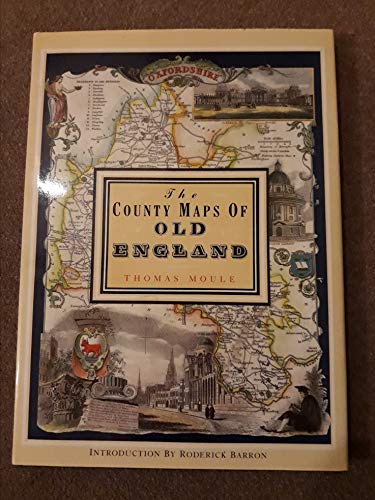
THE COUNTY MAPS OF OLD ENGLAND - Thomas Moule
Language: English
Published by Studio Editions, London, 1992
ISBN 10: 1851704035 ISBN 13: 9781851704033
Hardcover. Condition: Fine. Dust Jacket Condition: Fine. Fine copies of Moule's 56 maps in color from1830; 127pp. No name or writing. CLEAN!
-

Soft cover. Condition: Fine.
-
The County Maps of Old England
Language: English
Published by Studio Editions, London, 1990
ISBN 10: 1851704035 ISBN 13: 9781851704033
Cloth. Condition: Very Good. Dust Jacket Condition: Very Good. Clean and solid. ; Color Illustrations; Folio; 128 pages.
-

Decorative maps
Language: English
Published by London : Bracken Books, 1989
ISBN 10: 1851702989 ISBN 13: 9781851702985
First Edition
First Edition. Near fine paperback copy; wrapper edges very slightly dulled. Remains particularly well-preserved overall; tight, bright, clean and especially sharp-cornered. Physical description: 1 atlas (8 pages, 40 leaves of plates) : color maps ; 38 cm. Notes: Reproduces some plates and originals held by the British Museum and Jonathan Potter Ltd., London. Subjects: Great Britain Maps. Railroads Great Britain Maps. England. History - ; atlases. Genre: Atlas. Language: English. 3 Kg.
-

Decorative maps
Language: English
Published by London : Bracken Books, 1989
ISBN 10: 1851702989 ISBN 13: 9781851702985
First Edition
First Edition. Very good paperback copy; edges somewhat slightly dust-dulled and nicked. Remains particularly well-preserved overall; tight, bright, clean and strong. Physical description; 8 pages, 40 leaves of plates : color maps ; 39 cm. Subjects; Pictorial maps -- History. Cartography -- History. 3 Kg.
-

Condition: Bueno. : Descubre la fascinante historia de la cartograf�a con 'Mapas del Mundo' de Roderick Barron. Este libro te lleva en un viaje a trav�s de diferentes periodos, desde el mapa de Hereford hasta los mapas del siglo XIX de John Tallis y Thomas Moule. Con cuarenta l�minas a todo color, este volumen ofrece una visi�n detallada y rica de la evoluci�n de los mapas a lo largo del tiempo. Ideal para amantes de la geograf�a y la historia. EAN: 9788476300244 Tipo: Libros Categor�a: Historia T�tulo: Mapas del mundo Autor: Roderick Barron Editorial: Editorial LIBSA Idioma: es-ES Formato: tapa blanda.
-
The County Maps of Old England
Language: English
Published by Studio Editions, London, 1990
ISBN 10: 1851704035 ISBN 13: 9781851704033
Seller: Babushka Books & Framers, Isle of Wight, United Kingdom
Seller rating 4 out of 5 stars

First Edition
Hardcover. Condition: Very Good. Dust Jacket Condition: Very Good. 1st Edition.
-

Decorative maps
Language: English
Published by London : Bracken Books, 1989
ISBN 10: 1851702989 ISBN 13: 9781851702985
First Edition
First Edition. Near fine paperback copy; wrapper edges very slightly dulled. Remains particularly well-preserved overall; tight, bright, clean and especially sharp-cornered. Physical description: 1 atlas (8 pages, 40 leaves of plates) : color maps ; 38 cm. Notes: Reproduces some plates and originals held by the British Museum and Jonathan Potter Ltd., London. Subjects: Great Britain Maps. Railroads Great Britain Maps. England. History - ; atlases. Genre: Atlas. Language: English. 1 Kg.
-
Decorative Maps
Seller: Nugget Box (PBFA), Stafford, United Kingdom
Association Member: PBFA
Seller rating 5 out of 5 stars
Paperback. Condition: Fair. General wear to the book, cover, edges and corners. Slight age discolouration to page edges, small tear/rough edge to bottom corner of 2 pages done in production. Internally Good - clean and tidy copy in tight binding. A Good reference copy. **776g ** All orders are sent with a tracking /signature service for your peace of mind, so that you can keep tabs on your parcel. For overseas customers - on some sites we use, parcels weighing over the standard rate may incur an additional charge and we will then contact you with the additional shipping fee required. This is for the postage only we do not charge you for our time or our excellent packaging, which we are noted for. Dispatched in cardboard mailers within 24/48 Hours Mon - Friday 2pm, except bank holidays, otherwise next business day - excellent service guaranteed.; 88 pages.
-

Decorative maps
Language: English
Published by London : Bracken Books, 1989
ISBN 10: 1851702989 ISBN 13: 9781851702985
First Edition
First Edition. Very good paperback copy; edges somewhat slightly dust-dulled and nicked. Remains particularly well-preserved overall; tight, bright, clean and strong. Physical description; 8 pages, 40 leaves of plates : color maps ; 39 cm. Subjects; Pictorial maps -- History. Cartography -- History. 1 Kg.
-

Soft cover. Condition: Very Good. No Jacket. Some light wear to covers and spine, mainly edges and corners, top right corner of cover lightly creased, internally in good condition, pages crisp and clear.
-

Decorative Maps
Language: English
Published by London : Bracken Books, 1989
ISBN 10: 1851702989 ISBN 13: 9781851702985
Condition: Good. Paperback, 40 full colour plates, unpaged, folio.; Slightly foxed on cut; some foxing inside.
-
Decorative Maps
Language: English
Published by Crescent Books, Bracken Books, New York, 1989
ISBN 10: 0517688085 ISBN 13: 9780517688083
Seller: Ryde Bookshop Ltd, Isle of Wight, United Kingdom
Seller rating 5 out of 5 stars
Soft cover. Condition: Very Good. with forty full color plates (illustrator).
-

Decorative Maps
Language: English
Published by Studio Editions Ltd, London, 1990
ISBN 10: 1851702989 ISBN 13: 9781851702985
Seller: Washburn Books, Pateley Bridge, United Kingdom
Seller rating 5 out of 5 stars
Soft cover. Condition: Good. No Jacket. Reprint. Volume in the Poster Art Series. Collection of 40 decorative historical maps dated from the middle ages to the 19th century, with introduction and 40 full colour plates, each accompanied by a description. Slight peeling to the laminate cover and minor fading to spine, otherwise good copy with no inscriptions. Size: Folio - over 12 - 15" tall. Book.
-

Decorative Maps
Language: English
Published by London : Bracken Books, 1989
ISBN 10: 1851702989 ISBN 13: 9781851702985
Condition: Good. Paperback, 40 full colour plates, unpaged, folio.; Edges slightly browned.
-

Decorative Maps
Language: English
Published by Bracken Books, London, 1989
ISBN 10: 1851702989 ISBN 13: 9781851702985
Seller: Kilrimund Books, Gateside, FIFE, United Kingdom
Seller rating 5 out of 5 stars
First Edition
Soft cover. Condition: Near Fine. 1st Edition. Soft cover. Forty full colour plates. No inscriptions, Clean, bright, crisp and tight.
-
The County Maps of Old England.
Language: English
Published by London; Studio Editions. 1991., 1991
ISBN 10: 1851704035 ISBN 13: 9781851704033
Seller: Elaine Beardsell, HOLMFIRTH, United Kingdom
Association Member: PBFA
Seller rating 4 out of 5 stars
Hardcover. Condition: Fine. Dust Jacket Included. Reprint. 14" x 10". 126[1]pp, illustrated with 56 full plate cold maps. Fine hardback in price clipped, else, fine protected dustwrapper.
-
Condition: Very good.
-

R�stica. Condition: Normal. 28 x 38. Cuarenta l�minas a todo color. R�stica edit. impresa con mapas y dibujos a color, plastificada.
-
DECORATIVE MAPS
Seller: Richard Sylvanus Williams (Est 1976), WINTERTON, United Kingdom
Seller rating 5 out of 5 stars
Paperback. Condition: VG. Reprint. Book is in very good condition with minor signs of wear and/or age. Large format.
-
Encuadernaci�n de tapa blanda. Condition: Muy bueno. (Cartograf�a. Mapas antiguos). Madrid, Libsa, 1989. Col. Poster Art. Cubiertas originales en r�stica ilustrada. 8 p. + l�minas en color. Folio mayor (38 x 28 cm). Muy buen ejemplar. JL7047.
-

tapa blanda. Condition: Bien. null ((100)) Editorial Libsa. Madrid. 1989. 38 x 28 cm. 7 p�ginas, 40 hojas principalmente mapas. Encuadernaci�n en tapa blanda de editorial. Escala indeterminada. Los 40 mapas, que recoge este volumen, recorren diferentes periodos de la cartograf�a desde el mapa de Hereford hasta los mapas del siglo XIX de John Tallis y Thomas Moule. LIBSA. editor . Firma del anterior propietario. ISBN: 8476300247, 9788476300244 (=3643593=) PB152.
-
The County Maps of Old England
Language: English
Published by Studio Editions, London, 1990
ISBN 10: 1851704035 ISBN 13: 9781851704033
Hardcover. Condition: Fine. Dust Jacket Condition: Fine. Dark-blue hardcover with gilt lettering to spine, in glossy pictorial dust-jacket. 265 x 362 x 20mm. 127pp. High-quality colour reproductions with text on facing pages. A pristine copy - as new. NB: An extra shipping charge may be requested for heavier or more valuable items. All our 'Seller Images' show the actual item you will receive.
-
COUNTY MAPS OF OLD ENGLAND
Language: English
Published by Studio Editions, London, 1990
ISBN 10: 1851704035 ISBN 13: 9781851704033
Hardcover. Condition: New. Dust Jacket Condition: As New. Thomas Moule (illustrator). First Thgus. This copy is in new, unmarked condition bound in blue cloth covered boards with bright gilt titling to the spine. This copy is bright, tight, white and square. The unclipped dust wrapper is in as new condition. International postal rates are calculated on a book weighing 1 Kilo, in cases where the book weighs more than 1 Kilo increased postal rates will be quoted, where the book weighs less then postage will be reduced accordingly. Thomas Moule is one of the most distinctive and beloved of early Victorian mapmakers. His charming series of English county maps, first published in 1830 as the 'English Counties,' are as popular and collectible today as when they first appeared. Their elaborate and decorative style, a synthesis of art and cartography, sets them apart from most other maps of the period, whose plain unembellished style owed much to the pioneering work of the Ordinance Survey. Moule's maps convey a picture of an England where 'ancientness' could still be found in abundance. This was an England where history was still alive in ancient country houses, parish churches with their escutcheoned Gothic memorials and tombs, in market towns and market place and in a landscape that still offered 'scenes, situations, and prospects remarkable fro extent and beauty." Moule is often compared to his distinguished 17th century predecessors, John Speed and Joan Bleau. This new edition of 'Moule's Maps' combines 56 coloured maps with the original text taken from 'Barclays Complete and Universal English Dictionary' in which they appeared in the editions published between 1842 and 1852. Ref DDD 1.
-
Editorial Libsa, Madrid, 1989, 40 pags. Rustica. 28 x 37 cm.


