
Order Total (1 Item Items):
Shipping Destination:

Anthony Finley (127 results)
Skip to main search results
Search filters
Product Type
- All Product Types
- Books (95)
- Magazines & Periodicals (No further results match this refinement)
- Comics (No further results match this refinement)
- Sheet Music (No further results match this refinement)
- Art, Prints & Posters (24)
- Photographs (No further results match this refinement)
- Maps (8)
- Manuscripts & Paper Collectibles (No further results match this refinement)
Condition Learn more
- New (29)
- As New, Fine or Near Fine (28)
- Very Good or Good (16)
- Fair or Poor (No further results match this refinement)
- As Described (54)
Binding
Collectible Attributes
- First Edition (30)
- Signed (No further results match this refinement)
- Dust Jacket (1)
- Seller-Supplied Images (115)
- Not Print on Demand (101)
Language (2)
Free Shipping
Seller Location
Seller Rating
-

Tyler Perry's Why Did I Get Married?: The Play
Published by Liosngate Pictures Entertainment 2006-06-27 00:00:00, 2006
dvd. Condition: Used - Good.
-

FATE (Pulp Digest Magazine); Vol. 37, No. 5, Issue 410, May 1984 True Stories on The Strange, The Unusual, The Unknown -
Published by Clark Publishing Company,, Highland Park, IL, 1984
First Edition
Soft cover. Condition: VERY GOOD Minus. First Paperback Ed. & 1st Printing!. Inventory # D748-1 FATE (Pulp Digest Magazine); Vol. 37, No. 5, Issue 410, May 1984 True Stories on The Strange, The Unusual, The Unknown - Published by Highland Park, IL: Clark Publishing Company ** ARTICLES AND STORIES (1) Colombias Lost City by Edith Dajnhofer-Demar (2) Mr. Grimes, The Friendly Ghost by Willis H. Smith (3) Psychic Healer on Trial by Viviane Hewitt and Walter E. Baran (4) Stalking Bigfoot in Oklahoma by Bonnie Lake and Irwin Alpert (5) Phony Mystery of the J. C. Cousins by J. Finley Hurley (6) A Smashing English Poltergeist by Enid Anthony (7) The Medium Who Mystified a Magician by Rodger I. Anderson (8) Truth About Astrology by D. Scott Rogo (9) Telepathy Across the Frozen Wastes by Martin Ebon PRICE = $8; VG-; sticker to fc; minor wearing to fc ** AUTHORS; Edith Dajnhofer-Demar; Willis H. Smith; Viviane Hewitt and Walter E. Baran; Bonnie Lake and Irwin Alpert; J. Finley Hurley; Enid Anthony; Rodger I. Anderson; D. Scott Rogo; Martin Ebon Size: 12mo - over 6�" - 7�" tall. Book.
-

Gethsemane: Or, Thoughts on the Sufferings of Christ
Language: English
Published by HardPress Publishing, 2018
ISBN 10: 0461977494 ISBN 13: 9780461977493
Seller: PBShop.store UK, Fairford, GLOS, United Kingdom
Seller rating 5 out of 5 stars

PAP. Condition: New. New Book. Shipped from UK. Established seller since 2000.
-
Lake Barcroft History
Published by n.p.
Seller: Wonder Book, Frederick, MD, U.S.A.
Seller rating 5 out of 5 stars
Condition: As New. Like New condition. (US history, falls church, VA, virginia) A near perfect copy that may have very minor cosmetic defects.
-
Gethsemane: Or, Thoughts on the Sufferings of Christ
Seller: THE SAINT BOOKSTORE, Southport, United Kingdom
Seller rating 5 out of 5 stars
� 18.70
� 16.01 shipping
Ships from United Kingdom to U.S.A.Quantity: Over 20 available
Add to basketPaperback / softback. Condition: New. New copy - Usually dispatched within 4 working days.
-

Gethsemane
Language: English
Published by HardPress Publishing, 2020
ISBN 10: 0461977494 ISBN 13: 9780461977493
Condition: New. KlappentextrnrnThis is a reproduction of the original artefact. Generally these books are created from careful scans of the original. This allows us to preserve the book accurately and present it in the way the author intended. Since the origina.
-
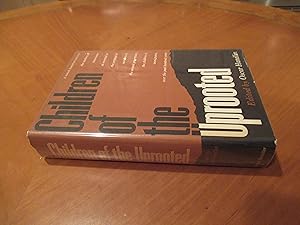
Children Of The Uprooted
Language: English
Published by George Braziller, New York City Ny, 1966
Seller: Arroyo Seco Books, Pasadena, Member IOBA, Pasadena, CA, U.S.A.
Association Member: IOBA
Seller rating 4 out of 5 stars

First Edition
Hardcover. Condition: Fine. Dust Jacket Condition: Near Fine. 1st Edition. Xxii, 551 Pp. Beige Cloth , Spine Stamped In Gilt And Black. First Printing Stated. Fine In Very Near Fine Dust Jacket Priced $8.50. Selections Of Sophisticated Writing About Or By Immigrants, Like The Majority Of Politicians, And Like Them Without Insight Into Their Own Characters, Focusing Always On Appearance, Feeling, And Achievement.
-

Condition: Gut. Brief/Blatt/Landkarte Altkolorierte Stahlstichkarte aus Finley: A New General Atlas mit Deutschland, �sterreich, Polen, Schweiz. Gestochen von Young & Delleker. Karte auf festem Kartonpapier mit kleinen Gebrauchsspuren, gering randfleckig. Sprache / Language: en 1 Seiten. ca. 26,6 x 34,5 cm.
-
OHIO [folding pocket map].
Language: English
Published by Anthony Finley, Philadelphia, PA, 1830
Seller: Kurt Gippert Bookseller (ABAA), Chicago, IL, U.S.A.
Association Member: ABAA ILAB MWABA
Seller rating 5 out of 5 stars
Map
Hardcover. Condition: Very good- condition. Reissue. 3-1/2" (height) x 2-1/8" (wide) original tan leather binding with gilt lettering "OHIO" on front cover, and decorative blind-tooled border. Contains an 11" x 8-1/2" hand-colored fold-out map with loss of one section at lower right corner (1" x 2-1/2") resulting in loss of cartouche, but not affecting image. A few tears at folds. The pastedown publisher's advertisement affixed to the inside front cover lists the date of 1830, but since the cartouche is lacking, it is unknown if this is the 1829 issue of the map, or an unrecorded 1830 issue. Americana; Michigan - Ohio border dispute.
-
A New General Atlas, Comprising a Complete Set of Maps, representing the Grand Divisions of the Globe, Together with the several Empires, Kingdoms and States in the World. Compiled from the Best Authorities and corrected by the Most Recent Discoveries, Philadelphia
Language: English
Published by Anthony Finley, Philadelphia, 1824
Seller: Argosy Book Store, ABAA, ILAB, New York, NY, U.S.A.
Seller rating 5 out of 5 stars
hardcover. Condition: very good. Young & Delleker (illustrator). First. Atlas. Illustrated with 58 hand colored engraved maps and 2 charts. Small folio (13.5" x 10.75"); publisher's half leather and marbled boards; spine is gilded in 6 compartments, faded; original printed green paper label on cover. Second issue of first edition. All engravings by Young & Delleker. Some wear to edges, minor dampstaining to endpaper and title page. Minor scattered foxing in margins, images mostly unaffected. Severe foxing to map of South America. Owner signature in pen on title page (John L. Brune ?). Philadelphia: Anthony Finley, 1824. Anthony Finley (c. 1790-1840) was a prominent American cartographic publisher in the early 19th century. "A New General Atlas" was well received and praised for its clearness and accuracy. Plates in this edition include 27 maps of North America (including Georgia, New England states, New York and Mexico), 17 of Europe and 8 of Asia, Africa and South America. Western and Eastern Hemispheres are also included, plus the world on the Mercator Projection. The 2 charts are comparative of mountains and rivers around the world.
-
New Hampshire, Hand-Colored Map 1827
Language: English
Published by Author: Finley, Anthony, Philadelphia, 1927
Seller: White Mountains, NH Books and Maps, Lincoln, NH, U.S.A.
Seller rating 4 out of 5 stars
No Binding. Condition: Near Fine. Young and Delleker (illustrator). Hand-coloring of each of the 7 counties, as well as the map's border done in Pink. County colors; Red, Orange, Blue, Green, Yellow. A pressed lithographic map with nice relief margins. Total area: 13.75" x 10.75", Map area: 11.25" x 8.5". A Colorful & Fine example of Finley's 1827 map of New Hampshire depicting the state with moderate detail as was Finley's classic minimalist style. Shows riverways, roads, canals, and other topographical features. Title and scale in the upper right quadrant. It is very uncommon to find an early 19th century exclusively depicting New Hampshire, as most maps of the period bundled it with Vermont. Identifies Grand Monadnock Mn., Moosehillock Mn., and Mount Washington. Moosehead lake (Maine) is shown listed by it's earlier title: "Moosetocmaguntic Lake". Engraved by Young and Delleker for the 1827 edition of Anthony Finley's General Atlas.
-
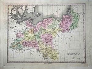
22x29 cm. From the first edition of Finley's General Atlas. Full color by district. Light offsetting throughout, likely from a paper which was pressed against it in storage for many years. Prussia extends east along the Baltic Sea to include most of modern northern Poland.
-
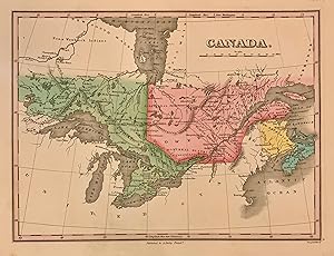
Canada
Published by Anthony Finley, Philadelphia, 1824
Seller: Argosy Book Store, ABAA, ILAB, New York, NY, U.S.A.
Seller rating 5 out of 5 stars
hardcover. Young & Delleker (illustrator). Map. Engraving with original hand coloring. Image measures 9" x 11 1/2" Beautiful early map of Canada, then known as Upper Canad and Lower Canada, Extending to Winnipeg River. Toronto is still named York, Roads, waterways, islands, geographical features are labeled. Great lakes are all labelled. Extensive notes on Indigenous regions are noted. In very good condition, with extra care taken with the original coloring. Anthony Finley (c. 1790-1840) was a prominent American cartographic publisher in the early 19th century. He is best known for his "New General Atlas", and "New American Atlas", which were well received and praised for their clearness and accuracy.
-
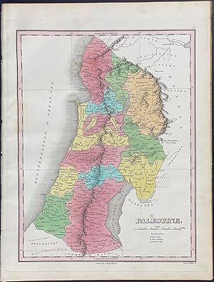
Map of Palestine
Published by Philadelphia, 1825
Seller: Trillium Antique Prints & Rare Books, Franklin, TN, U.S.A.
Seller rating 3 out of 5 stars

Art / Print / Poster
Soft cover. Condition: Fine. This hand-colored map is from Anthony Finley's "A New General Atlas, comprising a complete set of maps, representing the grand divisions of the globe. compiled from the best authorities, and corrected by the most recent discoveries". This is from the second edition of the work published in Philadelphia by the Author in 1825. --- It was said of this atlas: "The number of elegant maps and atlases which have come from the press within a short time in the United States, is a most flattering proof of increased attention of the community to the important study of geography. The present work contains sixty maps, about half of which are devoted to the American continent, and the remainder to other parts of the world, chiefly to Europe. The engraving is done almost uniformly with remarkable distinctness and the face of the maps is frequently beautiful, not overloaded with a confusion of useless names." (North American Review, July 1824, pp.261-262) --- The work is in very good to excellent condition overall. There may be a few minor imperfections or faint marks to be expected with age. Please review the image carefully for condition and contact us with any questions. --- Paper Size ~ 10" by 13 1/2".
-

Map of Russia
Published by Philadelphia, 1825
Seller: Trillium Antique Prints & Rare Books, Franklin, TN, U.S.A.
Seller rating 3 out of 5 stars
Art / Print / Poster
Soft cover. Condition: Fine. This hand-colored map is from Anthony Finley's "A New General Atlas, comprising a complete set of maps, representing the grand divisions of the globe. compiled from the best authorities, and corrected by the most recent discoveries". This is from the second edition of the work published in Philadelphia by the Author in 1825. --- It was said of this atlas: "The number of elegant maps and atlases which have come from the press within a short time in the United States, is a most flattering proof of increased attention of the community to the important study of geography. The present work contains sixty maps, about half of which are devoted to the American continent, and the remainder to other parts of the world, chiefly to Europe. The engraving is done almost uniformly with remarkable distinctness and the face of the maps is frequently beautiful, not overloaded with a confusion of useless names." (North American Review, July 1824, pp.261-262) --- The work is in very good to excellent condition overall. There may be a few minor imperfections or faint marks to be expected with age. Please review the image carefully for condition and contact us with any questions. --- Paper Size ~ 10" by 13 1/2".
-

Map of Europe
Published by Philadelphia, 1825
Seller: Trillium Antique Prints & Rare Books, Franklin, TN, U.S.A.
Seller rating 3 out of 5 stars
Art / Print / Poster
Soft cover. Condition: Fine. This hand-colored map is from Anthony Finley's "A New General Atlas, comprising a complete set of maps, representing the grand divisions of the globe. compiled from the best authorities, and corrected by the most recent discoveries". This is from the second edition of the work published in Philadelphia by the Author in 1825. --- It was said of this atlas: "The number of elegant maps and atlases which have come from the press within a short time in the United States, is a most flattering proof of increased attention of the community to the important study of geography. The present work contains sixty maps, about half of which are devoted to the American continent, and the remainder to other parts of the world, chiefly to Europe. The engraving is done almost uniformly with remarkable distinctness and the face of the maps is frequently beautiful, not overloaded with a confusion of useless names." (North American Review, July 1824, pp.261-262) --- The work is in very good to excellent condition overall. There may be a few minor imperfections or faint marks to be expected with age. Please review the image carefully for condition and contact us with any questions. --- Paper Size ~ 10" by 13 1/2".
-

Map of Germany
Published by Philadelphia, 1825
Seller: Trillium Antique Prints & Rare Books, Franklin, TN, U.S.A.
Seller rating 3 out of 5 stars
Art / Print / Poster
Soft cover. Condition: Fine. This hand-colored map is from Anthony Finley's "A New General Atlas, comprising a complete set of maps, representing the grand divisions of the globe. compiled from the best authorities, and corrected by the most recent discoveries". This is from the second edition of the work published in Philadelphia by the Author in 1825. --- It was said of this atlas: "The number of elegant maps and atlases which have come from the press within a short time in the United States, is a most flattering proof of increased attention of the community to the important study of geography. The present work contains sixty maps, about half of which are devoted to the American continent, and the remainder to other parts of the world, chiefly to Europe. The engraving is done almost uniformly with remarkable distinctness and the face of the maps is frequently beautiful, not overloaded with a confusion of useless names." (North American Review, July 1824, pp.261-262) --- The work is in very good to excellent condition overall. There may be a few minor imperfections or faint marks to be expected with age. Please review the image carefully for condition and contact us with any questions. --- Paper Size ~ 10" by 13 1/2".
-

Map of Russia in Europe
Published by Philadelphia, 1825
Seller: Trillium Antique Prints & Rare Books, Franklin, TN, U.S.A.
Seller rating 3 out of 5 stars
Art / Print / Poster
Soft cover. Condition: Fine. This hand-colored map is from Anthony Finley's "A New General Atlas, comprising a complete set of maps, representing the grand divisions of the globe. compiled from the best authorities, and corrected by the most recent discoveries". This is from the second edition of the work published in Philadelphia by the Author in 1825. --- It was said of this atlas: "The number of elegant maps and atlases which have come from the press within a short time in the United States, is a most flattering proof of increased attention of the community to the important study of geography. The present work contains sixty maps, about half of which are devoted to the American continent, and the remainder to other parts of the world, chiefly to Europe. The engraving is done almost uniformly with remarkable distinctness and the face of the maps is frequently beautiful, not overloaded with a confusion of useless names." (North American Review, July 1824, pp.261-262) --- The work is in very good to excellent condition overall. There may be a few minor imperfections or faint marks to be expected with age. Please review the image carefully for condition and contact us with any questions. --- Paper Size ~ 10" by 13 1/2".
-

Map of Scotland
Published by Philadelphia, 1825
Seller: Trillium Antique Prints & Rare Books, Franklin, TN, U.S.A.
Seller rating 3 out of 5 stars
Art / Print / Poster
Soft cover. Condition: Fine. This hand-colored map is from Anthony Finley's "A New General Atlas, comprising a complete set of maps, representing the grand divisions of the globe. compiled from the best authorities, and corrected by the most recent discoveries". This is from the second edition of the work published in Philadelphia by the Author in 1825. --- It was said of this atlas: "The number of elegant maps and atlases which have come from the press within a short time in the United States, is a most flattering proof of increased attention of the community to the important study of geography. The present work contains sixty maps, about half of which are devoted to the American continent, and the remainder to other parts of the world, chiefly to Europe. The engraving is done almost uniformly with remarkable distinctness and the face of the maps is frequently beautiful, not overloaded with a confusion of useless names." (North American Review, July 1824, pp.261-262) --- The work is in very good to excellent condition overall. There may be a few minor imperfections or faint marks to be expected with age. Please review the image carefully for condition and contact us with any questions. --- Paper Size ~ 10" by 13 1/2".
-

Map of Netherlands
Published by Philadelphia, 1825
Seller: Trillium Antique Prints & Rare Books, Franklin, TN, U.S.A.
Seller rating 3 out of 5 stars
Art / Print / Poster
Soft cover. Condition: Fine. This hand-colored map is from Anthony Finley's "A New General Atlas, comprising a complete set of maps, representing the grand divisions of the globe. compiled from the best authorities, and corrected by the most recent discoveries". This is from the second edition of the work published in Philadelphia by the Author in 1825. --- It was said of this atlas: "The number of elegant maps and atlases which have come from the press within a short time in the United States, is a most flattering proof of increased attention of the community to the important study of geography. The present work contains sixty maps, about half of which are devoted to the American continent, and the remainder to other parts of the world, chiefly to Europe. The engraving is done almost uniformly with remarkable distinctness and the face of the maps is frequently beautiful, not overloaded with a confusion of useless names." (North American Review, July 1824, pp.261-262) --- The work is in very good to excellent condition overall. There may be a few minor imperfections or faint marks to be expected with age. Please review the image carefully for condition and contact us with any questions. --- Paper Size ~ 10" by 13 1/2".
-

Map of Turkey in Asia
Published by Philadelphia, 1825
Seller: Trillium Antique Prints & Rare Books, Franklin, TN, U.S.A.
Seller rating 3 out of 5 stars
Art / Print / Poster
Soft cover. Condition: Fine. This hand-colored map is from Anthony Finley's "A New General Atlas, comprising a complete set of maps, representing the grand divisions of the globe. compiled from the best authorities, and corrected by the most recent discoveries". This is from the second edition of the work published in Philadelphia by the Author in 1825. --- It was said of this atlas: "The number of elegant maps and atlases which have come from the press within a short time in the United States, is a most flattering proof of increased attention of the community to the important study of geography. The present work contains sixty maps, about half of which are devoted to the American continent, and the remainder to other parts of the world, chiefly to Europe. The engraving is done almost uniformly with remarkable distinctness and the face of the maps is frequently beautiful, not overloaded with a confusion of useless names." (North American Review, July 1824, pp.261-262) --- The work is in very good to excellent condition overall. There may be a few minor imperfections or faint marks to be expected with age. Please review the image carefully for condition and contact us with any questions. --- Paper Size ~ 10" by 13 1/2".
-

Map of Russia in Asia
Published by Philadelphia, 1825
Seller: Trillium Antique Prints & Rare Books, Franklin, TN, U.S.A.
Seller rating 3 out of 5 stars
Art / Print / Poster
Soft cover. Condition: Fine. This hand-colored map is from Anthony Finley's "A New General Atlas, comprising a complete set of maps, representing the grand divisions of the globe. compiled from the best authorities, and corrected by the most recent discoveries". This is from the second edition of the work published in Philadelphia by the Author in 1825. --- It was said of this atlas: "The number of elegant maps and atlases which have come from the press within a short time in the United States, is a most flattering proof of increased attention of the community to the important study of geography. The present work contains sixty maps, about half of which are devoted to the American continent, and the remainder to other parts of the world, chiefly to Europe. The engraving is done almost uniformly with remarkable distinctness and the face of the maps is frequently beautiful, not overloaded with a confusion of useless names." (North American Review, July 1824, pp.261-262) --- The work is in very good to excellent condition overall. There may be a few minor imperfections or faint marks to be expected with age. Please review the image carefully for condition and contact us with any questions. --- Paper Size ~ 10" by 13 1/2".
-

Map of Holland
Published by Philadelphia, 1825
Seller: Trillium Antique Prints & Rare Books, Franklin, TN, U.S.A.
Seller rating 3 out of 5 stars
Art / Print / Poster
Soft cover. Condition: Fine. This hand-colored map is from Anthony Finley's "A New General Atlas, comprising a complete set of maps, representing the grand divisions of the globe. compiled from the best authorities, and corrected by the most recent discoveries". This is from the second edition of the work published in Philadelphia by the Author in 1825. --- It was said of this atlas: "The number of elegant maps and atlases which have come from the press within a short time in the United States, is a most flattering proof of increased attention of the community to the important study of geography. The present work contains sixty maps, about half of which are devoted to the American continent, and the remainder to other parts of the world, chiefly to Europe. The engraving is done almost uniformly with remarkable distinctness and the face of the maps is frequently beautiful, not overloaded with a confusion of useless names." (North American Review, July 1824, pp.261-262) --- The work is in very good to excellent condition overall. There may be a few minor imperfections or faint marks to be expected with age. Please review the image carefully for condition and contact us with any questions. --- Paper Size ~ 10" by 13 1/2".
-
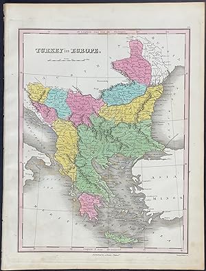
Map of Turkey in Europe
Published by Philadelphia, 1825
Seller: Trillium Antique Prints & Rare Books, Franklin, TN, U.S.A.
Seller rating 3 out of 5 stars
Art / Print / Poster
Soft cover. Condition: Fine. This hand-colored map is from Anthony Finley's "A New General Atlas, comprising a complete set of maps, representing the grand divisions of the globe. compiled from the best authorities, and corrected by the most recent discoveries". This is from the second edition of the work published in Philadelphia by the Author in 1825. --- It was said of this atlas: "The number of elegant maps and atlases which have come from the press within a short time in the United States, is a most flattering proof of increased attention of the community to the important study of geography. The present work contains sixty maps, about half of which are devoted to the American continent, and the remainder to other parts of the world, chiefly to Europe. The engraving is done almost uniformly with remarkable distinctness and the face of the maps is frequently beautiful, not overloaded with a confusion of useless names." (North American Review, July 1824, pp.261-262) --- The work is in very good to excellent condition overall. There may be a few minor imperfections or faint marks to be expected with age. Please review the image carefully for condition and contact us with any questions. --- Paper Size ~ 10" by 13 1/2".
-

Comparitive Length of Rivers
Published by Philadelphia, 1825
Seller: Trillium Antique Prints & Rare Books, Franklin, TN, U.S.A.
Seller rating 3 out of 5 stars
Art / Print / Poster
Soft cover. Condition: Fine. This hand-colored map is from Anthony Finley's "A New General Atlas, comprising a complete set of maps, representing the grand divisions of the globe. compiled from the best authorities, and corrected by the most recent discoveries". This is from the second edition of the work published in Philadelphia by the Author in 1825. --- It was said of this atlas: "The number of elegant maps and atlases which have come from the press within a short time in the United States, is a most flattering proof of increased attention of the community to the important study of geography. The present work contains sixty maps, about half of which are devoted to the American continent, and the remainder to other parts of the world, chiefly to Europe. The engraving is done almost uniformly with remarkable distinctness and the face of the maps is frequently beautiful, not overloaded with a confusion of useless names." (North American Review, July 1824, pp.261-262) --- The work is in very good to excellent condition overall. There may be a few minor imperfections or faint marks to be expected with age. Please review the image carefully for condition and contact us with any questions. --- Paper Size ~ 10" by 13 1/2".
-

Map of China
Published by Philadelphia, 1825
Seller: Trillium Antique Prints & Rare Books, Franklin, TN, U.S.A.
Seller rating 3 out of 5 stars
Art / Print / Poster
Soft cover. Condition: Fine. This hand-colored map is from Anthony Finley's "A New General Atlas, comprising a complete set of maps, representing the grand divisions of the globe. compiled from the best authorities, and corrected by the most recent discoveries". This is from the second edition of the work published in Philadelphia by the Author in 1825. --- It was said of this atlas: "The number of elegant maps and atlases which have come from the press within a short time in the United States, is a most flattering proof of increased attention of the community to the important study of geography. The present work contains sixty maps, about half of which are devoted to the American continent, and the remainder to other parts of the world, chiefly to Europe. The engraving is done almost uniformly with remarkable distinctness and the face of the maps is frequently beautiful, not overloaded with a confusion of useless names." (North American Review, July 1824, pp.261-262) --- The work is in very good to excellent condition overall. There may be a few minor imperfections or faint marks to be expected with age. Please review the image carefully for condition and contact us with any questions. --- Paper Size ~ 10" by 13 1/2".
-

Map of England & Wales
Published by Philadelphia, 1825
Seller: Trillium Antique Prints & Rare Books, Franklin, TN, U.S.A.
Seller rating 3 out of 5 stars
Art / Print / Poster
Soft cover. Condition: Fine. This hand-colored map is from Anthony Finley's "A New General Atlas, comprising a complete set of maps, representing the grand divisions of the globe. compiled from the best authorities, and corrected by the most recent discoveries". This is from the second edition of the work published in Philadelphia by the Author in 1825. --- It was said of this atlas: "The number of elegant maps and atlases which have come from the press within a short time in the United States, is a most flattering proof of increased attention of the community to the important study of geography. The present work contains sixty maps, about half of which are devoted to the American continent, and the remainder to other parts of the world, chiefly to Europe. The engraving is done almost uniformly with remarkable distinctness and the face of the maps is frequently beautiful, not overloaded with a confusion of useless names." (North American Review, July 1824, pp.261-262) --- The work is in very good to excellent condition overall. There may be a few minor imperfections or faint marks to be expected with age. Please review the image carefully for condition and contact us with any questions. --- Paper Size ~ 10" by 13 1/2".
-

Map of Austrian Empire
Published by Philadelphia, 1825
Seller: Trillium Antique Prints & Rare Books, Franklin, TN, U.S.A.
Seller rating 3 out of 5 stars
Art / Print / Poster
Soft cover. Condition: Fine. This hand-colored map is from Anthony Finley's "A New General Atlas, comprising a complete set of maps, representing the grand divisions of the globe. compiled from the best authorities, and corrected by the most recent discoveries". This is from the second edition of the work published in Philadelphia by the Author in 1825. --- It was said of this atlas: "The number of elegant maps and atlases which have come from the press within a short time in the United States, is a most flattering proof of increased attention of the community to the important study of geography. The present work contains sixty maps, about half of which are devoted to the American continent, and the remainder to other parts of the world, chiefly to Europe. The engraving is done almost uniformly with remarkable distinctness and the face of the maps is frequently beautiful, not overloaded with a confusion of useless names." (North American Review, July 1824, pp.261-262) --- The work is in very good to excellent condition overall. There may be a few minor imperfections or faint marks to be expected with age. Please review the image carefully for condition and contact us with any questions. --- Paper Size ~ 10" by 13 1/2".
-
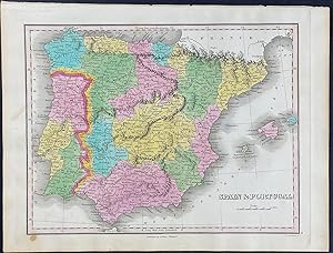
Map of Spain & Portugal
Published by Philadelphia, 1825
Seller: Trillium Antique Prints & Rare Books, Franklin, TN, U.S.A.
Seller rating 3 out of 5 stars
Art / Print / Poster
Soft cover. Condition: Fine. This hand-colored map is from Anthony Finley's "A New General Atlas, comprising a complete set of maps, representing the grand divisions of the globe. compiled from the best authorities, and corrected by the most recent discoveries". This is from the second edition of the work published in Philadelphia by the Author in 1825. --- It was said of this atlas: "The number of elegant maps and atlases which have come from the press within a short time in the United States, is a most flattering proof of increased attention of the community to the important study of geography. The present work contains sixty maps, about half of which are devoted to the American continent, and the remainder to other parts of the world, chiefly to Europe. The engraving is done almost uniformly with remarkable distinctness and the face of the maps is frequently beautiful, not overloaded with a confusion of useless names." (North American Review, July 1824, pp.261-262) --- The work is in very good to excellent condition overall. There may be a few minor imperfections or faint marks to be expected with age. Please review the image carefully for condition and contact us with any questions. --- Paper Size ~ 10" by 13 1/2".
-
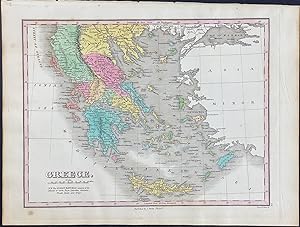
Map of Greece
Published by Philadelphia, 1825
Seller: Trillium Antique Prints & Rare Books, Franklin, TN, U.S.A.
Seller rating 3 out of 5 stars
Art / Print / Poster
Soft cover. Condition: Fine. This hand-colored map is from Anthony Finley's "A New General Atlas, comprising a complete set of maps, representing the grand divisions of the globe. compiled from the best authorities, and corrected by the most recent discoveries". This is from the second edition of the work published in Philadelphia by the Author in 1825. --- It was said of this atlas: "The number of elegant maps and atlases which have come from the press within a short time in the United States, is a most flattering proof of increased attention of the community to the important study of geography. The present work contains sixty maps, about half of which are devoted to the American continent, and the remainder to other parts of the world, chiefly to Europe. The engraving is done almost uniformly with remarkable distinctness and the face of the maps is frequently beautiful, not overloaded with a confusion of useless names." (North American Review, July 1824, pp.261-262) --- The work is in very good to excellent condition overall. There may be a few minor imperfections or faint marks to be expected with age. Please review the image carefully for condition and contact us with any questions. --- Paper Size ~ 10" by 13 1/2".

![Seller image for OHIO [folding pocket map]. for sale by Kurt Gippert Bookseller (ABAA)](https://pictures.abebooks.com/inventory/md/md58594672.jpg)
