
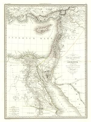
Carte de la Syrie et de l'Egypte ancienne [Syria and Ancient Egypt]
Lapie [Family]
Publication Date: 1833
Used
From
Antiqua Print Gallery, London, United Kingdom
Seller rating 3 out of 5 stars
![]()
AbeBooks Seller since 14 January 2022
This book is no longer available. AbeBooks has millions of books. Please enter search terms below to find similar copies.
About this Item
Description:
Carte de la Syrie et de l'Egypte ancienne. Syria Egypt Levant. LAPIE 1833 map. Large (folio) antique atlas map with original hand colour; Pierre Lapie, and Alexandre Emile Lapie (fils) (The publication date of the atlas within which this map was printed is stated on the title page as 1829, however the publication dates as printed on the individual maps within the volume vary from 1828 to 1836. The date of first publication of this map in the state shown is 1833 (this date is printed on the map), however the date of printing is likely to have been 1836). 63.5 x 50.0cm, 25 x 19.5 inches; this is a folding map. Condition: Good. Some of these maps have been blindstamped by the publisher as usual "Atlas Universel de Geographie (Lapie)" and the initials "EFB" of the publishers Eymery, Fruger & Brunet. There is nothing printed on the reverse side, which is plain. Seller Inventory # P-8-004805
Bibliographic Details
Title: Carte de la Syrie et de l'Egypte ancienne [...
Publication Date: 1833
Condition: Good
AbeBooks offers millions of new, used, rare and out-of-print books, as well as cheap textbooks from thousands of booksellers around the world. Shopping on AbeBooks is easy, safe and 100% secure - search for your book, purchase a copy via our secure checkout and the bookseller ships it straight to you.
Search thousands of booksellers selling millions of new & used books
New & Used Books

New and used copies of new releases, best sellers and award winners. Save money with our huge selection.
Rare & Out of Print Books

From scarce first editions to sought-after signatures, find an array of rare, valuable and highly collectible books.
