Order Total (1 Item Items):
Shipping Destination:

Road Map India Scale (13 results)
Skip to main search results
Search filters
Product Type
- All Product Types
- Books (10)
- Magazines & Periodicals (No further results match this refinement)
- Comics (No further results match this refinement)
- Sheet Music (No further results match this refinement)
- Art, Prints & Posters (No further results match this refinement)
- Photographs (No further results match this refinement)
- Maps (3)
- Manuscripts & Paper Collectibles (No further results match this refinement)
Condition Learn more
- New (No further results match this refinement)
- As New, Fine or Near Fine (No further results match this refinement)
- Very Good or Good (7)
- Fair or Poor (No further results match this refinement)
- As Described (6)
Binding
Collectible Attributes
- First Edition (1)
- Signed (No further results match this refinement)
- Dust Jacket (No further results match this refinement)
- Seller-Supplied Images (13)
- Not Print on Demand (13)
Language (2)
Free Shipping
- Free Shipping to U.S.A. (No further results match this refinement)
Seller Location
Seller Rating
-
Road map of India and adjacent countries. Scale 1 : 3 168 000. Published 1942. Reg. No. 2098. Ma�stab 1 : 3 168 000.
Language: English
Published by Printed at the survey of India Offices, sixth edition, 1942., 1942
Seller: Antiquariat Carl Wegner, Berlin, B, Germany
Association Member: GIAQ
Seller rating 5 out of 5 stars

First Edition
Softcover. 1 Karte. 110 x 90 cm, gefaltet auf 29 x 22 cm. An den R�ndern etwas l�diert. In den Falzen teilweise gebrochen. Noch ganz gut erhalten. -- Bitte Portokosten au�erhalb EU erfragen! / Please ask for postage costs outside EU! / S ' il vous plait demander des frais de port en dehors de l ' UE! // Bitte beachten Sie auch unsere Fotos! / Please also note our photos! / Veuillez noter nos photos -- Nehmen Sie sich ein gutes Buch mit auf die Sommerwiese. Bei uns werden Sie f�ndig! -- Wir kaufen Ihre werthaltigen B�cher! K01000-208184.
-

Road Map of India. Scale 50 Miles to an inch. Sixth Edition.
Language: English
Published by Survey of India, India, 1945
Seller: Carmarthenshire Rare Books, Carmarthen, United Kingdom
Seller rating 5 out of 5 stars
Soft cover. Condition: Very Good. Dust Jacket Condition: No Jacket Issued. original paper covers, large multi folding colour map, covers a little browned otherwise very good. We are a real bookshop with real books situated in and shipping from the United Kingdom. Shelf B242.
-
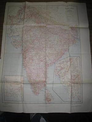
Road map of India : Scale: 1" inch to 50 miles
Published by Survey of India, Dehra Dun, 1945
Seller: Joseph Burridge Books, Dagenham, United Kingdom
Seller rating 5 out of 5 stars
Map
Hardcover. Condition: Very Good. 1 folded map : colour ; 104 x 75 cm. Notes: Relief shown by shading and spot heights "Published under the direction of . Surveyor General of India." "Preliminary edition 1926 . Reprinted 1942 with major corrections (6th edition). Reprinted 1943 (without corrections). 6th edition 1945 January (reprint of above)." Includes 2 insets showing eastern and western portions of India.
-

Road Map of India. Scale 50 Miles to an Inch. 1: 3,168,000
Language: English
Published by Calcutta, Map record & Issue Office, 1933
Map
36 Segmente auf Leinen aufgezogen. OLwd.-Mappe. 3. revised Edition. In engl. Sprache. [ca. 106,3 x 81 cm]. - Ebd. fleckig, R. etw. angeplatzt u. m. 2 kl. L�chern, ansonsten leichte Gbrsp. Gutes Expl. - Cover spotty, spine a little frayed with two small holes, else small signs of use. Good copy.
-
Road Map of India Scale 50 miles to 1 inch
Language: English
Publication Date: 1942
Seller: Hugh Hardinge Books, Cambridge, United Kingdom
Seller rating 5 out of 5 stars
Hardcover. Condition: Very Good. 5th or later Edition. Linen map encased in blue boards, the latter worn and splitting and stamped inside with a written name, Undamaged map (with a blue circular stamp) measures 108 cm x 80 cm in 36 sections. Reprint of the 5th edition.
-

Road Map of India Scale 1:50
Published by Survey of India Office, India
Seller: St Marys Books And Prints, Stamford, United Kingdom
Seller rating 4 out of 5 stars

Sixth Edition. Sixth Edition Folding map some discolouration and wear to edges but overall in good condition Contents clean and bright in colour with sections magnified for detail Approximately 114cm 45 inches in height and 87 cm 30 inches in width when unfolded nbsp. book.
-
The Road Map of India; Showing all Roads and Relative Information Based on a Physical Survey Made by the Individual Automobile Associations in India [Scale 1 cm. : 20 Kilometres]
Published by Published by The Federation of Indian Automobile Associations, Bombay. Cartographer and Produced by Mudran Kala Mandir. Stated First Edition February . 1970., 1970
Seller: Little Stour Books PBFA Member, Canterbury, United Kingdom
Association Member: PBFA
Seller rating 5 out of 5 stars
Condition: Very Good. Coarsely woven backed cloth covers. Folded size 9�'' x 6�''. Scale of 1 cm. : 20 Kilometres. 56 section linen backed colour outlined map opening to 66�'' x 46''. Light fraying to the edges and in Very Good clean condition. Member of the P.B.F.A. INDIA (Bharat Ganarajya).
-
![Seller image for Road Map of India. Scale 1" = 50 Miles [Cover Title] for sale by Aquila Books(Cameron Treleaven) ABAC](https://pictures.abebooks.com/inventory/md/md725779393.jpg)
Road Map of India. Scale 1" = 50 Miles [Cover Title]
Published by Calcutta Survey of India Office 1939, 1939
Seller: Aquila Books(Cameron Treleaven) ABAC, Calgary, AB, Canada
Association Member: ABAC ILAB PBFA
Seller rating 3 out of 5 stars

Condition: good to very good. 5th '1939' Edition. Mappp. Large colour map (qpprox. 39.5" x 29.25") backed on linen folding into Small Octavo blue cloth case. A few tears in folds, case spine repaired with light blue cloth tape. good to very good.
-
2nd, revised edition of this road map used by administrators and military officers. Folds out on linen back paper. Map size approximately 80 X 110cm. Covers worn and unevenly marked The map is in VG condition. To the endpapers is an Ambala booksellers label and ownership inscription of A Colley, Ambala 1936.
-
Road Map of India ( Excluding Burma). Scale 1"= 50 Miles.
Published by Survey of India Map Office. 13, Wood Street, Calcutta.
Map
Soft cover. Condition: Good. Dated to 1928 from rear card cover evidence. 6by5=30 panel folded paper map in card cover. Good condition unless you are put off by a bit of foxing in which case you may choose to see it as good minus or even Fair-to-Good !!! A fairly seldom ( In King George I's usage) map. And without Burma to boot.
-
Hardback. Condition: Very Good. Showing distances in miles, information regarding petrol food, lodging boundaries, obstruction, etc. Pages clean and bright, no markings, light wear to edges. Binding tight. ALL ITEMS ARE DISPATCHED FROM THE UK WITHIN 48 HOURS ( BOOKS ORDERED OVER THE WEEKEND DISPATCHED ON MONDAY) ALL OVERSEAS ORDERS SENT BY TRACKABLE AIR MAIL. IF YOU ARE LOCATED OUTSIDE THE UK PLEASE ASK US FOR A POSTAGE QUOTE FOR MULTI VOLUME SETS BEFORE ORDERING.
-
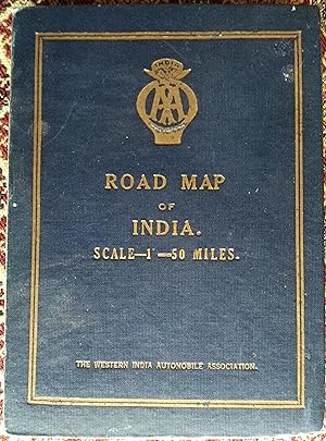
Road Map of India Scale 1" = 50 Miles
Published by The Western India Automobile Association, Calcutta, 1929
Hardcover. Condition: Very Good. No Jacket. This is a Road Map of India produced by the Western Indian Automobile Association in 1929 - 8 years after the incorporation of the company in 1921. In Very good condition dissected and laid down on Linen. Size 2'9" X 3'6" (81 X 108cm), size folded 5.5" X 7.5".
-
![Seller image for Road Map of India. Scale 1 inch to 50 miles [1:300,000]. Sixth Edition. SURVEY OF INDIA: ROAD MAP for sale by Island Books](https://pictures.abebooks.com/inventory/md/md30718778604.jpg)
Road Map of India. Scale 1 inch to 50 miles [1:300,000]. Sixth Edition. SURVEY OF INDIA: ROAD MAP
Published by Survey of India,, 1946
Seller: Island Books, Thakeham, West Sussex, United Kingdom
Seller rating 4 out of 5 stars
Folding coloured map on paper measuring 44 x 31 ins (approx. 112 x 79 cms), folding in 36 panels to 7.5 x 5.25 ins (approx. 19 x 13 cms); printed wrapper, covers mildly age-soiled (but map itself remakably bright and clean), a bright copy. A SCARCE SURVIVAL.


![Seller image for The Road Map of India; Showing all Roads and Relative Information Based on a Physical Survey Made by the Individual Automobile Associations in India [Scale 1 cm. : 20 Kilometres] for sale by Little Stour Books PBFA Member](https://pictures.abebooks.com/inventory/md/md12611697620.jpg)