Prussia by Engraved Map (3 results)
 More images
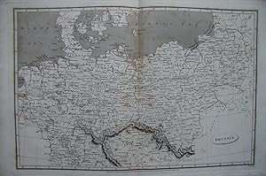
Published by Longman, Hurst, Rees & Orme., London. 1808
- Map
Seller: N. G. Lawrie Books, sheffield, , United KingdomN. G. Lawrie Books
Contact seller5-star sellerCondition: Used - Very good
£ 15.00
£ 9.50 shippingShips from United Kingdom to U.S.A.Quantity: 1 available
Map. Condition: Very Good. Engraved by Lowry after Arrowsmith. Published in Ree's Cyclopedia or Universal Dictionary, early 1800s. Overall measures 11 1/4 x 17 1/4 inches. Centre fold and light spotting.

Language: English
Seller: K Books Ltd ABA ILAB, York, YORKS, United KingdomK Books Ltd ABA ILAB
Contact seller5-star sellerCondition: Used - Very good
£ 35.00
£ 19.50 shippingShips from United Kingdom to U.S.A.Quantity: 1 available
No Binding. Condition: Very Good. A fine antique map in very good condition - printed in circa 1844. Mounted (matted) and ready to frame. Engraved size approx 16 x 13 Ins, 41 x 33 Cms. Mounted size approx 19 x 16 in, 49 x 41cm. Coloured in outline, hand colouring contemporary. A fine engraved map of Germany - Showing Hungary, Ty…rol, Switzerland, Prussia Etc. Engraved By Walker (illustrator).

Published by Johnson & Browning, Richmond, VA 1861
- Softcover
- First Edition
- Art Print
Seller: Dorley House Books, Inc., Hagerstown, MD, U.S.A.Dorley House Books, Inc.
Contact seller4-star sellerCondition: Used - Very good
£ 134.45
£ 6.45 shippingShips within U.S.A.Quantity: 1 available
Unbound. Condition: Very Good. 1st. Plate #72, 73; lovely double page hand-colored map; of Prussia, Norway, Sweden & Denmark at the beginning of the US Civil War, decorative strapwork border; w/ Counties, cities, roads, rivers, railroads, wagon roads,canals, ports, etc & with 2 engravings Size: 17" x 24.5". Handcolored Map (illu…strator).

