
Order Total (1 Item Items):
Shipping Destination:

Plan Cincinnati Vicinity (24 results)
Skip to main search results
Search filters
Product Type
- All Product Types
- Books (20)
- Magazines & Periodicals (No further results match this refinement)
- Comics (No further results match this refinement)
- Sheet Music (No further results match this refinement)
- Art, Prints & Posters (1)
- Photographs (No further results match this refinement)
- Maps (3)
- Manuscripts & Paper Collectibles (No further results match this refinement)
Condition Learn more
- New (No further results match this refinement)
- As New, Fine or Near Fine (1)
- Very Good or Good (2)
- Fair or Poor (No further results match this refinement)
- As Described (21)
Binding
- All Bindings
- Hardcover (No further results match this refinement)
- Softcover (No further results match this refinement)
Collectible Attributes
- First Edition (No further results match this refinement)
- Signed (No further results match this refinement)
- Dust Jacket (No further results match this refinement)
- Seller-Supplied Images (22)
- Not Print on Demand (24)
Language (1)
Free Shipping
- Free Shipping to U.S.A. (No further results match this refinement)
Seller Location
Seller Rating
-

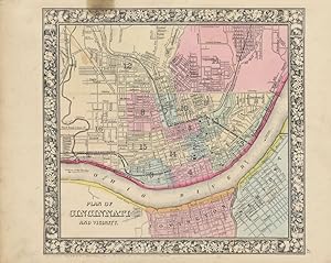
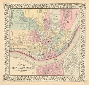
Plan of Cincinnati and Vicinity
Published by Philadelphia c.1865, Philadelphia, 1865
Seller: High Ridge Books, Inc. - ABAA, South Deerfield, MA, U.S.A.
Association Member: ABAA ESA ILAB SNEAB
Seller rating 5 out of 5 stars

Map from Mitchell's General Atlas of Cincinnati, with nearby portions of Covington and Newport, Kentucky. Very good to fine condition, with slight chipping at upper edge of top margin. Full color by ward. The copyright date is 1860, though the exact date of publication is not showsn. This was map no.37 in the atlas.
-

PLAN OF CINCINNATI AND VICINITY. [S. Augustus Mitchell hand-colored 1860 map of Cincinnati, Ohio and portions of Covington and Newport, Kentucky.]
Published by [Philadelphia]: S. Augustus Mitchell, 1860., 1860
Seller: David Hallinan, Bookseller, Columbus, MS, U.S.A.
Seller rating 4 out of 5 stars

Single one-sided sheet from Mitchell's atlas with 1860 copyright statement at lower left. Sheet dimensions: H 15 1/4 inches x L 12 9/16 inches. Map dimensions including floral border (image orientated horizontally): approx. H 10 5/8 inches x L 11 1/4 inches. Some foxing and toning and several short tears at margins; small stain at lower right margin; sheet's removal from atlas caused several shallow chips at gutter/spine edge. Floral border. Map's color in pink, blue, and muted yellow.
-
![Seller image for Plan of Cincinnati and Vicinity [MAP] for sale by Trevian Books](https://pictures.abebooks.com/inventory/md/md17791646728.jpg)
Plan of Cincinnati and Vicinity [MAP]
Published by Philadelphia: Mitchell, 1860, 1860
1860 edition. Hand-colored lithograph map of Cincinnati, from an atlas published in 1860. 10.5 x 11 inches image size; sheet size 12 x 15.5 inches. Colors bright.
-
Plan of Cincinnati and Vicinity
Published by S. Augustus Mitchell, Jr., New York, 1860
Seller: Main Street Fine Books & Mss, ABAA, Galena, IL, U.S.A.
Association Member: ABAA ILAB MWABA
Seller rating 5 out of 5 stars
Map
Folio (15�" X 12�", image area 11" X 10 3/4"). Hand colored. Very good. Light age toning and bit of soiling; single small at upper left, slightly touching printed border. Nice example of this detailed city plan, from the 1864 edition of "Mitchell's New General Atlas, Containing Maps of the Various Countries of the World, Plans of Cities, Etc." Large and bold floral border and well done original colors.
-

Plan of Cincinnati and Vicinity
Published by Mitchell, Samuel Augustus Jr., Philadelphia, 1860
Seller: Argosy Book Store, ABAA, ILAB, New York, NY, U.S.A.
Seller rating 5 out of 5 stars
unbound. Condition: very good. Map. Engraving with original hand coloring. Image measures 10.5" x 11.25". Great city plan of Cincinnati showing streets, several notable buildings, the Ohio River and railroads. Small tear to upper right edge. Samuel Augustus Mitchell Sr. (1792-1868) was one of the leaders in American cartography of the 19th century and pioneered the conversion of engraved map plates to more affordable lithographic plates. His son, Samuel Augustus Mitchell Jr. continued his father's successful mapmaking and publishing business, and was one of the most prolific and renowned 19th century American publishers.
-

Plan of Cincinnati and Vicinity
Publication Date: 1887
Seller: Art Source International Inc., Boulder, CO, U.S.A.
Seller rating 5 out of 5 stars
This map was made by S. Augustus Mitchell for "Mitchells New General Atlas" published in 1887. The well maintained maps in this atlas feature Mitchell's characteristic pastel coloring and abundant details of geographical features. The plan of Cincinnati is illustrated on this map. Details include the names of streets, important buildings, rivers, lakes, parks and railroads. Sections of the city are distinguished by color. These 1887 maps offer a fascinating perspective of areas that have since undergone significant growth and change, in addition to their value as great examples of Mitchell's work. This map measures 11.5 inches by 11 inches.
-

Plan of Cincinnati and Vicinity
Publication Date: 1877
Seller: Art Source International Inc., Boulder, CO, U.S.A.
Seller rating 5 out of 5 stars
This hand colored map was made for "Mitchells New General Atlas" published in 1877 by S. Augustus Mitchell. The city of Cincinnati, Ohio is illustrated on this map. Sections of the city are highlighted by different colors. Other details include the names of streets and parks, railroads,and rivers. This map measures 11.25 inches by 10.5 inches.
-

Plan of Cincinnati and Vicinity
Publication Date: 1868
Seller: Art Source International Inc., Boulder, CO, U.S.A.
Seller rating 5 out of 5 stars
This hand colored map was made for "Mitchells New General Atlas" published in 1868 by S. Augustus Mitchell, Jr. The plan of Cincinnati Ohio is illustrated on this map. Sections of the city are distinguished by color. Other details include the names of counties and important cities, railroads, major roads,and rivers. The pastel coloring in this atlas is very beautiful and more muted than typical. This map measures 11.25 inches by 10.75 inches.
-

Plan of Cincinnati and Vicinity
Publication Date: 1864
Seller: Art Source International Inc., Boulder, CO, U.S.A.
Seller rating 5 out of 5 stars
The Mitchell company was one of the first to try out the new technique of engraving on steel plates, experimenting with steel almost 20 years before the rest of the publishing industry. He was printing with steel in the early 1830s; the general switch to steel was approximately 1850. During the early years of the company, Mitchell published mainly maps and travel guides. In 1860, Mitchell started producing "Mitchell's New General Atlas", and Mitchell Sr. retired and turned the business over to his son of the same name. The New General Atlas was published until 1893. Today Mitchell maps are sought after for their fine engraving, bright coloring, and attention to detail. They are some of the finest maps produced in the 1860's. This map produced in 1864, shows Mitchell's famous artsy flower border, which is only seen in the early editions of his atlases. This map shows Louisiana, Mississippi and Arkansas. This map details, railroads, proposed railroads, cities and towns, rivers and mountains, Native American Indian tribes, wagon trails, forts, and counties. This map measures 11.25 inches by 10.25 inches.
-

Plan of Cincinnati and Vicinity
Publication Date: 1870
Seller: Art Source International Inc., Boulder, CO, U.S.A.
Seller rating 5 out of 5 stars
S. Augustus Mitchell,Jr. made this hand colored map for Mitchells New General Atlas in 1870. Cincinnati is illustrated on this map. Sections of the city are distinguished by bright pastel colors. The railroads, rivers, parks and the names of streets are identified. This map measures 11.25 inches by 10.75 inches.
-

Plan of Cincinnati and Vicinity
Publication Date: 1888
Seller: Art Source International Inc., Boulder, CO, U.S.A.
Seller rating 5 out of 5 stars
This map of Cincinnati, Ohio was made by S. Augustus Mitchell for "Mitchells New General Atlas" published in 1888, by WM. M. Bradley & Co. The well maintained maps in this atlas feature Mitchell's characteristic pastel coloring and abundant details of geographical features. Details include the names of streets, railroads, transportation routes, rivers, and various points of interest. These 1888 maps offer a fascinating perspective of areas that have since undergone significant growth and change, in addition to their value as great examples of Mitchell's work. This map measures 11.5 inches by 11 inches.
-

Plan of Cincinnati and Vicinity
Publication Date: 1884
Seller: Art Source International Inc., Boulder, CO, U.S.A.
Seller rating 5 out of 5 stars
This map was made by S. Augustus Mitchell for "Mitchell's New General Atlas" published in 1884, by WM. M. Bradley & Co. The well maintained maps in this atlas feature Mitchell's characteristic pastel coloring and abundant geographical features. Details include the names of streets, rail roads, depots, canals, parks, rivers and creeks. City sections are distinguished by color. These 1884 maps offer a fascinating perspective of areas that have since undergone significant growth and change, in addition to their value as great examples of Mitchell's work. This map measures 10.75 inches by 11.5 inches.
-

Plan of Cincinnati and Vicinity
Publication Date: 1875
Seller: Art Source International Inc., Boulder, CO, U.S.A.
Seller rating 5 out of 5 stars
This map was produced by S. Augustus Mitchell in 1875 for his New General Atlas. This map shows Mitchells traditional grape vine border, characteristic pastel coloring and abundant details of geographical features. Counties are distinguished by different colors. Wagon trails and major routes of transport are also shown. These 1875 maps offer a fascinating perspective of areas that have since undergone significant growth and change, in addition to their value as great examples of Mitchell's work. This map measures 11.5 inches by 10.5 inches.
-

Plan of Cincinnati and Vicinity
Publication Date: 1885
Seller: Art Source International Inc., Boulder, CO, U.S.A.
Seller rating 5 out of 5 stars
This map was made by S. Augustus Mitchell for "Mitchells New General Atlas" published in 1885, by WM. M. Bradley & Co. The well maintained maps in this atlas feature Mitchell's characteristic pastel coloring and abundant details of geographical features. The city of Cincinnati is illustrated. Details include the names of streets, rail roads, depots, canals, parks, the Ohio river and Mill creek. City sections are distinguished by color. These 1885 maps offer a fascinating perspective of areas that have since undergone significant growth and change, in addition to their value as great examples of Mitchell's work. This map measures 10 inches by 12 inches.
-

Plan of the Cincinnati and Vicinity
Publication Date: 1866
Seller: Art Source International Inc., Boulder, CO, U.S.A.
Seller rating 5 out of 5 stars
The Mitchell company was one of the first to try out the new technique of engraving on steel plates experimenting with steel almost 20 years before the rest of the publishing industry. He was printing with steel in the early 1830s; the general switch to steel was approximately 1850. During the early years of the company, Mitchell published mainly maps and travel guides. In 1860, Mitchell started producing "Mitchell's New General Atlas",and Mitchell Sr. retired and turned the business over to his sonof the same name. The New General Atlas was published until1893. Today Mitchell maps are sought after for their fine engraving, bright coloring, and attention to detail. They aresome of the finest maps produced during this time period. This map produced in 1866, has Mitchell's unique floral border, and beautiful hand coloring. This map details the City of Cincinnati. Counties, cities, towns, lakes, rivers, mountains, and transportation routes are noted. Each map was printed on thick paper with vibrant hand color. This map measures 11.25 inches by 10.75 inches.
-

Plan of Cincinnati and Vicinity
Publication Date: 1872
Seller: Art Source International Inc., Boulder, CO, U.S.A.
Seller rating 5 out of 5 stars
This map of Cincinnati, Ohio was made by S. Augustus Mitchell in 1872. The traditional ivy border, and hand coloring make thismap beautiful. This city map shows transportationroutes, railroads and rivers. City areas are distinguished by various pastel colors. VeryDetailed! This map measures 11 inches by 10.5 inches.
-

Plan of Cincinnati and Vicinity
Publication Date: 1874
Seller: Art Source International Inc., Boulder, CO, U.S.A.
Seller rating 5 out of 5 stars
This map was produced by S. Augustus Mitchell in 1874 for his New General Atlas. This map shows Mitchells traditional grape vine border, characteristic pastel coloring and abundant details of geographical features. The City of Cinncinnati is illustrated on this map. Townships are distinguished by color. These 1874 maps offer a fascinating perspective of areas that have since undergone significant growth and change, in addition to their value as great examples of Mitchell's work. This map measures 14 inches by 11 inches.
-
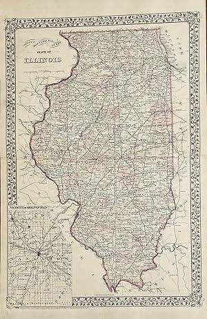
County and Township Map of the State of Illinois Plan of Cincinnati and Vicinity
Published by Mitchell, S. Augustus, Philadelphia, 1879
Map
14 1/4 x 21 2=3/4 inches. Mitchell, S. Augustus (illustrator). 1879 edition. Contemporary-color highlights this double page map. The State of Illinois covers 400+ miles from North to South. This map show all the counties along with the townships within. A dramatic rr network is shown. The Illinois Central Railroad, Chicago and Alton Railroad and the Rock Island Railroad are accurately shown among the network.On the versos can be found a one page map of Cincinnati and Vicinity. It two has a well defined rr network. The Amin map has an inset of Central Illinois centered on Springfield. Very good with separations to the folds at the extremes repaired with archival mending tape.
-

Plan of the City of Cincinnati and Vicinity
Publication Date: 1867
Seller: Art Source International Inc., Boulder, CO, U.S.A.
Seller rating 5 out of 5 stars
The Mitchell company was one of the first to try out the newtechnique of engraving on steel plates, experimenting with steelalmost 20 years before the rest of the publishing industry. Hewas printing with steel in the early 1830s; the general switch tosteel was approximately 1850. During the early years of thecompany, Mitchell published mainly maps and travel guides. In1860, Mitchell started producing "Mitchell's New General Atlas",and Mitchell Sr. retired and turned the business over to his sonof the same name. The New General Atlas was published until1893. Today Mitchell maps are sought after for their fineengraving, bright coloring, and attention to detail. They aresome of the finest maps produced in the 1860's. This mapproduced in 1867, has Mitchell's unique floral border, and beautiful hand coloring. This map details the city of Cincinnati. Streets, important downtown buildings, railroads, canals, and proposed railroads are illustrated. This map measures 11 inches by 10.5 inches.
-
Plan of Cincinnati and vicinity.
Published by Philadelphia,, 1867
Seller: libreria antiquaria perini Sas di Perini, Verona, VR, Italy
Seller rating 5 out of 5 stars
Art / Print / Poster
Incisione in acciaio, dipinta d'epoca a tutto campo, mm 290x355. Pianta della citt? entro bordura decorativa con vitigno intrecciato. Buon esemplare ben conservato, minime macchie marginali e numero "64" manoscritto coevo all'ang. inf. destro.
-

Plan of Cincinnati and Vicinity - The city of Cincinnati shortly after the Civil War.
Publication Date: 1867
Seller: Curtis Wright Maps, Berwyn, IL, U.S.A.
Seller rating 5 out of 5 stars
Condition: Fine. This detailed street map of Cincinnati was published in Philadelphia in 1867 by Samuel Augustus Mitchell. Mitchell was one of the most prominent American mapmakers of the 19th century and initially got involved with cartography as a school teacher who was frustrated with the quality of available maps. He collaborated with skilled engravers and produced high-quality maps and atlases that contained the most up-to-date information available. Mitchell's son (of the same name) would take over the business after his death in 1860 and continue the tremendous output. His attention to detail is evident within the image, which provides an engaging overview of The Queen City shortly after the conclusion of the Civil War. Bright colors highlight the sixteen different numbered wards and separate towns of Covington and Newport, across the Ohio River in Kentucky. A robust transportation network of horse-drawn streetcars is shown, as well as the three railroads in operation. Numerous important buildings are outlined and labeled throughout the image, including transportation depots, hotels, schools, and amusements. Sheet Width (in) 15.25 Sheet Height (in) 12.5 Condition Description Light spotting and soiling visible in the margins. Unevenly trimmed edges and a bit of light soiling in the image near the title block. Very good condition, with original hand color.
-

Mitchell's 1865 Map of the Plan of Cincinnati and Vicinity
Publication Date: 1865
Seller: Art Source International Inc., Boulder, CO, U.S.A.
Seller rating 5 out of 5 stars
In 1860 S. Augustus Mitchell Jr. took over his father's map publishing business and in that year he started publishing Mitchell's New General Atlas. Editions of the new general were issued annually until 1887. Mitchell Jr. continued publishing this atlas until 1879. The editions from 1880 to 1887 were published by Wm. M. Bradley. This map published in 1865 is a wonderful example of Mitchell's map-making prowess with beautiful original hand-coloring. This map measures 11.25 inches by 10.5 inches.
-
Condition: Good. "City "Plan of the City of Cincinnati" by Samuel Augustus Mitchell 1869 map. Decorative antique atlas map with original hand colour; Samuel Augustus Mitchell Jr. (1869). 29.5 x 31.0cm, 11.5 x 12.25 inches. Condition: Good. There is nothing printed on the reverse side, which is plain.".
-

Plan of Cincinnati and Vicinity
Publication Date: 1874
Seller: Art Source International Inc., Boulder, CO, U.S.A.
Seller rating 5 out of 5 stars
Art Source International is proud to offer this very rare city map of Cincinnati. It was produced for S. Augustus Mitchells New Atlas of the United States, published for a single year by Ziegler & McCurdy, in 1874. This single edition is one of the most sought after editions of any American published maps. The maps are distinguished by their decorative "airplane propeller" border. Streets, railroads, points of interest, and various geographic features are shown on this map. We have found only one map by Ziegler and McCurdy in over 35 years of map sales records and have never, till now, offered any for sale. This map measures 11 inches by 10.5 inches.
