Map Texas by Rand Mcnally (42 results)

Seller: World of Books (was SecondSale), Montgomery, IL, U.S.A.World of Books (was SecondSale)
Contact seller5-star sellerCondition: Used - Good
£ 4.98
Free ShippingShips within U.S.A.Quantity: 1 available
Condition: Good. Item in good condition. Textbooks may not include supplemental items i.e. CDs, access codes etc.

- Map
Seller: Your Online Bookstore, Houston, TX, U.S.A.Your Online Bookstore
Contact seller5-star sellerCondition: Used - Good
£ 5.02
Free ShippingShips within U.S.A.Quantity: 1 available
map. Condition: Good.

Seller: Hawking Books, Edgewood, TX, U.S.A.Hawking Books
Contact seller4-star sellerCondition: Used - Very good
£ 6.15
Free ShippingShips within U.S.A.Quantity: 1 available
Condition: Very Good. Very Good Condition. Five star seller - Buy with confidence.

Seller: Better World Books: West, Reno, NV, U.S.A.Better World Books: West
Contact seller5-star sellerCondition: Used - Good
£ 7.60
Free ShippingShips within U.S.A.Quantity: 1 available
Condition: Good. Pages intact with minimal writing/highlighting. The binding may be loose and creased. Dust jackets/supplements are not included. Stock photo provided. Product includes identifying sticker. Better World Books: Buy Books. Do Good.

Seller: Lakeside Books, Benton Harbor, MI, U.S.A.Lakeside Books
Contact seller5-star sellerCondition: New
£ 6.30
£ 3.02 shippingShips within U.S.A.Quantity: 3 available
Condition: New. Brand New! Not Overstocks or Low Quality Book Club Editions! Direct From the Publisher! We're not a giant, faceless warehouse organization! We're a small town bookstore that loves books and loves it's customers! Buy from Lakeside Books.

Seller: BooksRun, Philadelphia, PA, U.S.A.BooksRun
Contact seller5-star sellerCondition: Used - Fair
£ 9.73
Free ShippingShips within U.S.A.Quantity: 1 available
Map. Condition: Fair. The item might be beaten up but readable. May contain markings or highlighting, as well as stains, bent corners, or any other major defect, but the text is not obscured in any way.

- Softcover
Seller: WorldofBooks, Goring-By-Sea, WS, United KingdomWorldofBooks
Contact seller5-star sellerCondition: Used - Fair
£ 8.52
£ 5.60 shippingShips from United Kingdom to U.S.A.Quantity: 1 available
Paperback. Condition: Fair. A readable copy of the book which may include some defects such as highlighting and notes. Cover and pages may be creased and show discolouration.
- Softcover
Seller: WorldofBooks, Goring-By-Sea, WS, United KingdomWorldofBooks
Contact seller5-star sellerCondition: Used - Very good
£ 8.52
£ 5.60 shippingShips from United Kingdom to U.S.A.Quantity: 1 available
Paperback. Condition: Very Good. The book has been read, but is in excellent condition. Pages are intact and not marred by notes or highlighting. The spine remains undamaged.
Seller: World of Books (was SecondSale), Montgomery, IL, U.S.A.World of Books (was SecondSale)
Contact seller5-star sellerCondition: Used - Good
£ 15.19
Free ShippingShips within U.S.A.Quantity: 1 available
Condition: Good. Item in good condition. Textbooks may not include supplemental items i.e. CDs, access codes etc.

Seller: Big River Books, Powder Springs, GA, U.S.A.Big River Books
Contact seller5-star sellerCondition: Used - Good
£ 13.83
£ 3.02 shippingShips within U.S.A.Quantity: 1 available
Condition: good. This book is in good condition. The cover has minor creases or bends. The binding is tight and pages are intact. Some pages may have writing or highlighting.

Seller: medimops, Berlin, Germanymedimops
Contact seller5-star sellerCondition: Used - Very good
£ 8.47
£ 8.63 shippingShips from Germany to U.S.A.Quantity: 1 available
Condition: very good. Gut/Very good: Buch bzw. Schutzumschlag mit wenigen Gebrauchsspuren an Einband, Schutzumschlag oder Seiten. / Describes a book or dust jacket that does show some signs of wear on either the binding, dust jacket or pages.

Language: English
Published by Rand McNally & Company, Chicago 1911
- Softcover
- First Edition
Seller: The Wright Collection, Waxahachie, TX, U.S.A.The Wright Collection
Contact seller5-star sellerAssociation member: TXBA
Stiff Wrs. Condition: Good. No Jacket. 1st Edition. 110 pp., ads, index. Accompanied by a new and original compilation and ready reference index, showing in detail the ENTIRE RAILROAD SYSTEM. Includes population according to the latest Official Census. Covers loose and reattached with archival tape. Fragile.
- Map
Seller: Revaluation Books, Exeter, United KingdomRevaluation Books
Contact seller5-star sellerCondition: New
£ 8.13
£ 10.00 shippingShips from United Kingdom to U.S.A.Quantity: 1 available
Map. Condition: Brand New. 8.98x3.86x0.94 inches. In Stock.
Seller: Reuseabook, Gloucester, GLOS, United KingdomReuseabook
Contact seller5-star sellerCondition: Used - Good
£ 8.17
£ 10.00 shippingShips from United Kingdom to U.S.A.Quantity: 1 available
Map. Condition: Used; Good. Dispatched, from the UK, within 48 hours of ordering. This book is in good condition but will show signs of previous ownership. Please expect some creasing to the spine and/or minor damage to the cover.

- Map
Seller: Revaluation Books, Exeter, United KingdomRevaluation Books
Contact seller5-star sellerCondition: New
£ 9.19
£ 10.00 shippingShips from United Kingdom to U.S.A.Quantity: 1 available
Map. Condition: Brand New. 8.94x4.17x0.51 inches. In Stock.
- Map
Seller: Revaluation Books, Exeter, United KingdomRevaluation Books
Contact seller5-star sellerCondition: New
£ 9.28
£ 10.00 shippingShips from United Kingdom to U.S.A.Quantity: 1 available
Map. Condition: Brand New. 8.94x4.17x0.51 inches. In Stock.
Seller: Russell Books, Victoria, BC, CanadaRussell Books
Contact seller5-star sellerCondition: New
£ 7.49
£ 15.14 shippingShips from Canada to U.S.A.Quantity: 1 available
map. Condition: New. Special order direct from the distributor.
Published by LaSalle Extension University, Chicago 1920
- Map
Seller: Stephen Peterson, Bookseller, Eden Prairie, MN, U.S.A.Stephen Peterson, Bookseller
Contact seller5-star sellerNo Binding. Condition: Good. Good-minus, 18" X 11.5" map with edge tears and chipping. Most tears and chips are in margins, but one chip in top edge intrudes slightly into map area. Undated, but circa 1920.
Seller: Russell Books, Victoria, BC, CanadaRussell Books
Contact seller5-star sellerCondition: New
£ 8.58
£ 15.14 shippingShips from Canada to U.S.A.Quantity: 3 available
map. Condition: New. Special order direct from the distributor.
- Map
Seller: Revaluation Books, Exeter, United KingdomRevaluation Books
Contact seller5-star sellerCondition: New
£ 18.92
£ 10.00 shippingShips from United Kingdom to U.S.A.Quantity: 1 available
Map. Condition: Brand New. 8.98x3.86x0.94 inches. In Stock.

Seller: Art Source International Inc., Boulder, CO, U.S.A.Art Source International Inc.
Contact seller5-star sellerWith the 19th century innovations of publishing and technology, the world became a smaller place and one which anyone could become acquainted with. As these changes blossomed, the fledgling company of Rand McNally realized the interest in small accessible material, and produced a pocket atlas. These maps carry handy reference in…formation, and were up to date for the period. They include cities, some towns as well as some roads. They have their own charm and would be great for framing, and decorative use. This map measures 3 inches by 5 inches.

Seller: Art Source International Inc., Boulder, CO, U.S.A.Art Source International Inc.
Contact seller5-star sellerRand McNally & Company, still a major name in map publishing to this day, began as a small print shop opened in Chicago in 1856 by William H. Rand. The shop originally printed guidebooks and directories. In 1858, Rand hired Andrew McNally who was later to become a partner. Within the next few years, the shop got into the railroa…d business by starting to print railway tickets and schedules, a key step in the development of the company. The ticket printing led to the publishing of railway guides, and by 1872 Rand McNally and Company had the capacity to publish maps. This map of Texas came from Rand McNally's Commercial Atlas. A highly successful run of atlases that lasted over a decade. These maps were primarily used by business, because of their accurate listing of railroads in operation as well as tables of statistical information. This map measures 26 inches by 19 inches.

Seller: Art Source International Inc., Boulder, CO, U.S.A.Art Source International Inc.
Contact seller5-star sellerWith the 19th century innovations of publishing and technology, the world became a smaller place and one which anyone could become acquainted with. As these changes blossomed, the fledgling company of Rand McNally realized the interest in small accessible material, and produced a pocket atlas. These maps carry handy reference in…formation, and were up to date for the period. They include cities, some towns as well as some roads. They have their own charm and would be great for framing, and decorative use. This map measures 3 inches by 5 inches.
Published by RAND, McNALLY & COMPANY, Chicago 1885
- Hardcover
Seller: T. W. Palmer Books, Eugene, OR, U.S.A.T. W. Palmer Books
Contact seller5-star sellerHardcover. Condition: Good. 17 x 10.5 cm., 55pp., text, plus 2 folding colored maps, one attached and one loose,(substantial tears on loose map on fold lines), booklet is bound but front hinge is separating.
Published by Rand McNally & Company, Chicago, Illinois 1882
- Hardcover
Seller: T. W. Palmer Books, Eugene, OR, U.S.A.T. W. Palmer Books
Contact seller5-star sellerCondition: Used - Very good
£ 1,560.64
£ 3.79 shippingShips within U.S.A.Quantity: 2 available
Hardcover. Condition: Very Good. No Jacket. 16.5 x 10.5 cm, 57, [3 pages advertisements] pp., includes list of 32 railroads, list of counties with area and 1880 census population, lists of creeks, islands, towns etc. Map 64 x 76 cm to neat lines, color lithography, extremely detailed with emphasis on railroads. booklet in very g…ood condition with separation at inside front hinge. Map is on fragile paper with separations at a number of folds, but absolutely complete (should be laid down on linen). In original blind stamped brown folder with bright gilt lettering and near fine condition except for one bumped corner.

Seller: Art Source International Inc., Boulder, CO, U.S.A.Art Source International Inc.
Contact seller5-star sellerRand McNally & Company, still a major name in map publishing to this day, began as a small print shop opened in Chicago in 1856 by William H. Rand. The shop originally printed guidebooks and directories. In 1858, Rand hired Andrew McNally who was later to become a partner. Within the next few years, the shop got into the railroa…d business by starting to print railway tickets and schedules, a key step in the development of the company. The ticket printing led to the publishing of railway guides, and by 1872 Rand McNally and Company had the capacity to publish maps. This map of Texas, Northern Section came from Rand McNally's Commercial Atlas. A highly successful run of atlases that lasted over a decade. These maps were primarily used by business, because of their accurate listing of railroads in operation as well as tables of statistical information. This map is unique in several ways, their large format makes an impressive display, and offers additional room where many small towns and extra details are included. Additionally a list of every railroad operating in the state in 1932 is included. All railroad routes are shown on the map. This map includes all cities and towns, lakes, rivers, and bodies of water. All topographical features are also included as well as political features such as counties and Native American Indian reservations. This map measures 26 inches by 19 inches.

Seller: Art Source International Inc., Boulder, CO, U.S.A.Art Source International Inc.
Contact seller5-star sellerRand McNally & Company, still a major name in map publishing to this day, began as a small print shop opened in Chicago in 1856 by William H. Rand. The shop originally printed guidebooks and directories. In 1858, Rand hired Andrew McNally who was later to become a partner. Within the next few years, the shop got into the railroa…d business by starting to print railway tickets and schedules, a key step in the development of the company. The ticket printing led to the publishing of railway guides, and by 1872 Rand McNally and Company had the capacity to publish maps. This map of Texas came from Rand McNallys Commercial Atlas. A highly successful run of atlases that lasted over a decade. These maps were primarily used by business, because of their accurate listing of railroads in operation as well as tables of statistical information.This map is unique in several ways, their large format makes an impressive display, and offers additional room where many small towns and extra details are included. Additionally a list of every railroad operating in the state in 1932 is included. All railroad routes are shown on the map. This map includes all cities and towns, lakes, rivers, and bodies of water. All topographical features are also included as well as political features such as counties and Native American Indian reservations. This map measures 17 inches by 11 inches.

Seller: Art Source International Inc., Boulder, CO, U.S.A.Art Source International Inc.
Contact seller5-star sellerThis map was produced by Rand McNally and Co. as part of its 1928 Commercial Atlas of America. These maps are some of our favorite maps because of the large size of each map sheet. The detail shown on each map is exceptional because of the map size. These maps were intended to be used by business for shipping and other uses. Roa…ds, railroads, rivers, and buildings are clearly shown. There is more detail on these maps than any others during this time period. This map measures 8.25 inches by 11 inches.

Seller: Art Source International Inc., Boulder, CO, U.S.A.Art Source International Inc.
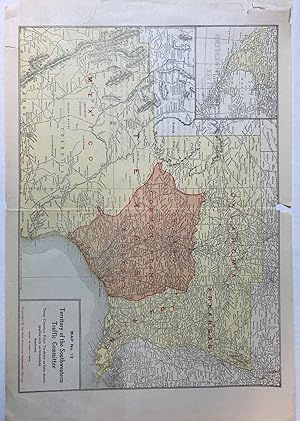
Contact seller5-star sellerRand McNally & Company, still a major name in map publishing to this day, began as a small print shop opened in Chicago in 1856 by William H. Rand. The shop originally printed guidebooks and directories. In 1858, Rand hired Andrew McNally who was later to become a partner. Within the next few years, the shop got into the railroa…d business by starting to print railway tickets and schedules, a key step in the development of the company. The ticket printing led to the publishing of railway guides, and by 1872 Rand McNally and Company had the capacity to publish maps. This map of Texas, Southern Section came from Rand McNally's Commercial Atlas. A highly successful run of atlases that lasted over a decade. These maps were primarily used by business, because of their accurate listing of railroads in operation as well as tables of statistical information. This map is unique in several ways, their large format makes an impressive display, and offers additional room where many small towns and extra details are included. Additionally a list of every railroad operating in the state in 1932 is included. All railroad routes are shown on the map. This map includes all cities and towns, lakes, rivers, and bodies of water. All topographical features are also included as well as political features such as counties and Native American Indian reservations. This map measures 26 inches by 19 inches.


