Order Total (1 Item Items):
Shipping Destination:

Brussels by Rapkin John (5 results)
Skip to main search results
Search filters
Product Type
- All Product Types
- Books (3)
- Magazines & Periodicals (No further results match this refinement)
- Comics (No further results match this refinement)
- Sheet Music (No further results match this refinement)
- Art, Prints & Posters (2)
- Photographs (No further results match this refinement)
- Maps (No further results match this refinement)
- Manuscripts & Paper Collectibles (No further results match this refinement)
Condition Learn more
- New (No further results match this refinement)
- As New, Fine or Near Fine (2)
- Very Good or Good (No further results match this refinement)
- Fair or Poor (No further results match this refinement)
- As Described (3)
Binding
- All Bindings
- Hardcover (No further results match this refinement)
- Softcover (No further results match this refinement)
Collectible Attributes
- First Edition (No further results match this refinement)
- Signed (No further results match this refinement)
- Dust Jacket (No further results match this refinement)
- Seller-Supplied Images (5)
- Not Print on Demand (5)
Language (2)
Price
- Any Price
- Under £ 20 (No further results match this refinement)
- £ 20 to £ 35 (No further results match this refinement)
- Over £ 35
Free Shipping
- Free Shipping to U.S.A. (No further results match this refinement)
Seller Location
Seller Rating
-
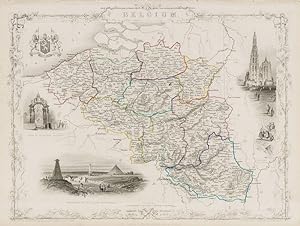
Belgium - with Vignettes of Antwerp Cathedral, Monuments on the Plains of Waterloo and the Altar of St Gudule, Brussels.
Language: English
Published by London, Edinburgh & Dublin, J & F. Tallis, 1851
Seller: Inanna Rare Books Ltd., Skibbereen, CORK, Ireland
Seller rating 5 out of 5 stars

Art / Print / Poster
Condition: Wie neu. Original steel engraving / Vintage map. Drawn and engraved by John Rapkin. Partly hand-coloured. Illustrations by J. Marchant and engravings by J.B. Allen. Plate Size: 34 cm x 26.3 cm. Sheet Size: 27.1 cm x 37.5 cm. Vintage 19th century map in very good condition. Published in the Illustrated Atlas, And Modern History Of The World Geographical, Political, Commercial & Statistical, Edited By R. Montgomery Martin. Beautiful and interesting map of Belgium from the Victorian Era. The political sub-divisions are shown on the map, with provinces such as West Flanders, Limburg and the Grand Duchy of Luxembourg included. The North Sea, France, Prussia and Holland all conspire to surround Belgium. The canal and railway systems are included on the map, linking famous and historic cities such as Bruges and Ghent. The map is crowded with the names of towns and cities, highlighting the population density of this much fought over part of the continent - known as the 'cockpit of Europe.' To the south and east the rugged topography - like that of the Ardennes - is depicted pictorially and through hachuring. John Tallis (7 November 1817 3 June 1876) was an English cartographic publisher. His company, John Tallis and Company, published views, maps and atlases in London from roughly 1838 to 1851. Tallis set up as a publisher with Frederick Tallis in Cripplegate in 1842; the business moved to Smithfield in 1846, and was dissolved in 1849. From 1851 to 1854 Tallis operated as John Tallis and Company. He started The illustrated news of the world and national portrait gallery of eminent personages in 1858, selling it for £1,370 in 1861; it folded in 1863. (Wikipedia) The most important project John Tallis undertook, was the 'Illustrated Atlas' from 1851. The original map we offer here, was part of this exceptional Atlas and all the maps it contained are still today considered as the last reminder of an era of lavish map production. Tallis worked the project together with John Rapkin (1815-1876) and it was Rapkin's style and talent that we have to thank for when we marvel at these maps today. What makes these maps so special is the detail of engraved vignettes that surround the map and often show indigenous scenes, people in their environment and even more so, historical buildings or historical views of towns and cities, architecture and landscape. The project of 'The Illustrated Atlas' was designed to be finished just in time for the anxiously awaited "Great Exhibition of the Works of Industry of All Nations" or The Great Exhibition, sometimes referred to as the Crystal Palace Exhibition in reference to the temporary structure in which it was held, was an international exhibition that took place in Hyde Park, London, from 1 May to 11 October 1851. It was the first in a series of World's Fairs, exhibitions of culture and industry that became popular in the 19th century, and it was a much-anticipated event. The Great Exhibition was organized by Henry Cole and Prince Albert, husband of the reigning monarch, Queen Victoria. It was attended by numerous notable figures of the time, including Charles Darwin, Samuel Colt, members of the Orléanist Royal Family and the writers Charlotte Brontë, Charles Dickens, Lewis Carroll, George Eliot and Alfred Tennyson. Music for the opening was under the direction of Sir George Thomas Smart and the continuous music from the exhibited organs for the Queen's procession was "under the superintendence of William Sterndale Bennett". (Wikipedia).
-
Brussels - With Beautiful Vignettes of Brussels near the Porte D'Anderlecht, Avenue in the Park, Palace Royal, Hotel de Ville, and Church of St Gudule.
Language: English
Published by London & New York, John Tallis & Company, 1851
Seller: Inanna Rare Books Ltd., Skibbereen, CORK, Ireland
Seller rating 5 out of 5 stars
Art / Print / Poster
Condition: Wie neu. Original steel engraving / Vintage map. Drawn and engraved by John Rapkin. Illustrated and Engraved by J. Watkins Plate Size: 32.5 cm x 26 cm. Sheet Size: 37.2 cm x 27.2 cm. Vintage 19th century map / city-plan in very good condition. Published in the Illustrated Atlas, And Modern History Of The World Geographical, Political, Commercial & Statistical, Edited By R. Montgomery Martin. Handsome town-plan of Brussels. The River Seine can be seen near the top of the map. Canals, railway, street and district areas of the city are also included. Decorative scrolling and title cartouche around the edges of the map. The project of 'The Illustrated Atlas' was designed to be finished just in time for the anxiously awaited "Great Exhibition of the Works of Industry of All Nations" or The Great Exhibition, sometimes referred to as the Crystal Palace Exhibition in reference to the temporary structure in which it was held, was an international exhibition that took place in Hyde Park, London, from 1 May to 11 October 1851. It was the first in a series of World's Fairs, exhibitions of culture and industry that became popular in the 19th century, and it was a much-anticipated event. The Great Exhibition was organized by Henry Cole and Prince Albert, husband of the reigning monarch, Queen Victoria. It was attended by numerous notable figures of the time, including Charles Darwin, Samuel Colt, members of the Orléanist Royal Family and the writers Charlotte Brontë, Charles Dickens, Lewis Carroll, George Eliot and Alfred Tennyson. Music for the opening was under the direction of Sir George Thomas Smart and the continuous music from the exhibited organs for the Queen's procession was "under the superintendence of William Sterndale Bennett". (Wikipedia).
-

Brussels, antique map with vignette views
Published by John Tallis & Co., London, 1854
Seller: Antipodean Books, Maps & Prints, ABAA, Garrison, NY, U.S.A.
Association Member: ABAA ANZAAB ESA ILAB
Seller rating 4 out of 5 stars

Maps. Steel engraved map from the famous Victorian publisher John Tallis, well-known for the attractive vignette views surrounding the maps, which illustrate the peoples & customs of that region. This map with vignettes of Striking full color example of Tallis's town plan of Brussels. Includes vignettes of Hotel de Ville, Palace Royal, View from near Port Anderlecht Church of St. Gudule, and Avenue in the Park. 10 x 13 1/2" plus margins. Attractive decorative border around edge, very good condition.
-

Brussels
Published by John Tallis & Company, London, 1851
Seller: Argosy Book Store, ABAA, ILAB, New York, NY, U.S.A.
Seller rating 5 out of 5 stars
unbound. Rapkin, J.; Watkins, J. (illustrator). Map. Original engraving. Page measures 13 7/8" x 10 5/8" Lovely map of Brussels, Belgium in the mid-19th century surrounded by a decorative border. Five vignettes adorn the map, featuring illustrations of the Palace Royal, Hotel de Ville, Church of St. Gudule, an Avenue in the Park, and Brussels near the Porte D'Anderlecht. Map drawn and engraved by J. Rapkin; illustrations drawn and engraved by J. Watkins. In very good condition. John Tallis Jr. (1817-1876) was a London born bookseller who continued the prolific map publishing company started by his father. After a partnership with his brother, Tallis Jr. expanded the business to New York in 1849 as well as Boston, Cincinnati, Rochester, Philadelphia and Baltimore. He is remembered as one of the last decorative map makers.
-

Brussels.
Published by The Illustrated Atlas and Modern History of the World Geographical, Political, Commercial & Statistical. John Tallis & Company. 1851, 1851
Seller: Peter Harrington. ABA/ ILAB., London, United Kingdom
Association Member: ABA ILAB PBFA
Seller rating 5 out of 5 stars
A highly decorative city plan of Brussels, with five vignettes views of parts of the city. The plan and the vignettes are surrounded by an elegant uncoloured border. Steel engraving. In fine condition. Original outline colour, later additions. Size: 35 x 25 cm. (14 x 10 inches).