Rapkin John 1817 (71 results)
 More images
Central America with Guatemala, Honduras, Salvador, Nicaragua, [Mosquito Territory] and Vignettes and illustrations of Belise [Belize, formerly British Honduras], the Volcano of Isalco and The Great Square of the Antigua in Guatemala.
America / Central America / Latin America / Guatemala - Tallis, John / Rapkin, John. (1817 - 1876)
Language: English
Published by London & New York, J & F. Tallis, 1851
- Art / Print / Poster
Seller: Inanna Rare Books Ltd., Skibbereen, CORK, IrelandInanna Rare Books Ltd.
Contact seller5-star sellerCondition: Used - As new
£ 197.72
£ 23.89 shippingShips from Ireland to U.S.A.Quantity: 1 available
Add to basketCondition: Wie neu. Original steel engraving / Vintage map. Drawn and engraved by John Rapkin. Partly hand-coloured. Plate Size: 32.4 cm x 27.3 cm. Sheet Size: 37.5 cm x 27.4 cm. Vintage 19th century map in very good condition. John Tallis (7 November 1817 3 June 1876) was an English cartographic publisher. His company, John Tal…lis and Company, published views, maps and atlases in London from roughly 1838 to 1851. Tallis set up as a publisher with Frederick Tallis in Cripplegate in 1842; the business moved to Smithfield in 1846, and was dissolved in 1849. From 1851 to 1854 Tallis operated as John Tallis and Company. He started The illustrated news of the world and national portrait gallery of eminent personages in 1858, selling it for £1,370 in 1861; it folded in 1863. (Wikipedia) The most important project John Tallis undertook, was the 'Illustrated Atlas' from 1851. The original map we offer here, was part of this exceptional Atlas and all the maps it contained are still today considered as the last reminder of an era of lavish map production. Tallis worked the project together with John Rapkin (1815-1876) and it was Rapkin's style and talent that we have to thank for when we marvel at these maps today. What makes these maps so special is the detail of engraved vignettes that surround the map and often show indigenous scenes, people in their environment and even more so, historical buildings or historical views of towns and cities, architecture and landscape. The project of 'The Illustrated Atlas' was designed to be finished just in time for the anxiously awaited "Great Exhibition of the Works of Industry of All Nations" or The Great Exhibition, sometimes referred to as the Crystal Palace Exhibition in reference to the temporary structure in which it was held, was an international exhibition that took place in Hyde Park, London, from 1 May to 11 October 1851. It was the first in a series of World's Fairs, exhibitions of culture and industry that became popular in the 19th century, and it was a much anticipated event. The Great Exhibition was organized by Henry Cole and Prince Albert, husband of the reigning monarch, Queen Victoria. It was attended by numerous notable figures of the time, including Charles Darwin, Samuel Colt, members of the Orléanist Royal Family and the writers Charlotte Brontë, Charles Dickens, Lewis Carroll, George Eliot and Alfred Tennyson. Music for the opening was under the direction of Sir George Thomas Smart and the continuous music from the exhibited organs for the Queen's procession was "under the superintendence of William Sterndale Bennett". (Wikipedia).
 More images
Isthmus of Panama with vignettes and illustrations of The Fort of Chagres and Gold Seekers on their way over the Cordilleras [with an engraved Note: 'The Proposed Railway and Canal communications are coloured' [in pink]]
America / Central America / Latin America / Panama - Tallis, John / Rapkin, John. (1817 - 1876)
Language: English
Published by London & New York, J & F. Tallis, 1851
- Art / Print / Poster
Seller: Inanna Rare Books Ltd., Skibbereen, CORK, IrelandInanna Rare Books Ltd.
Contact seller5-star sellerCondition: Used - As new
£ 197.72
£ 23.89 shippingShips from Ireland to U.S.A.Quantity: 1 available
Add to basketCondition: Wie neu. Original steel engraving / Vintage map. Drawn and engraved by John Rapkin. Partly hand-coloured. Plate Size: 33.2 cm x 24.6 cm. Sheet Size: 37.5 cm x 27.3 cm. Vintage 19th century map in very good condition. John Tallis (7 November 1817 3 June 1876) was an English cartographic publisher. His company, John Tal…lis and Company, published views, maps and atlases in London from roughly 1838 to 1851. Tallis set up as a publisher with Frederick Tallis in Cripplegate in 1842; the business moved to Smithfield in 1846, and was dissolved in 1849. From 1851 to 1854 Tallis operated as John Tallis and Company. He started The illustrated news of the world and national portrait gallery of eminent personages in 1858, selling it for £1,370 in 1861; it folded in 1863. (Wikipedia) The most important project John Tallis undertook, was the 'Illustrated Atlas' from 1851. The original map we offer here, was part of this exceptional Atlas and all the maps it contained are still today considered as the last reminder of an era of lavish map production. Tallis worked the project together with John Rapkin (1815-1876) and it was Rapkin's style and talent that we have to thank for when we marvel at these maps today. What makes these maps so special is the detail of engraved vignettes that surround the map and often show indigenous scenes, people in their environment and even more so, historical buildings or historical views of towns and cities, architecture and landscape. The project of 'The Illustrated Atlas' was designed to be finished just in time for the anxiously awaited "Great Exhibition of the Works of Industry of All Nations" or The Great Exhibition, sometimes referred to as the Crystal Palace Exhibition in reference to the temporary structure in which it was held, was an international exhibition that took place in Hyde Park, London, from 1 May to 11 October 1851. It was the first in a series of World's Fairs, exhibitions of culture and industry that became popular in the 19th century, and it was a much anticipated event. The Great Exhibition was organized by Henry Cole and Prince Albert, husband of the reigning monarch, Queen Victoria. It was attended by numerous notable figures of the time, including Charles Darwin, Samuel Colt, members of the Orléanist Royal Family and the writers Charlotte Brontë, Charles Dickens, Lewis Carroll, George Eliot and Alfred Tennyson. Music for the opening was under the direction of Sir George Thomas Smart and the continuous music from the exhibited organs for the Queen's procession was "under the superintendence of William Sterndale Bennett". (Wikipedia).
 More images
Language: English
Published by London & New York, John Tallis & Company, 1851
- Art / Print / Poster
Seller: Inanna Rare Books Ltd., Skibbereen, CORK, IrelandInanna Rare Books Ltd.
Contact seller5-star sellerCondition: Used - As new
£ 197.72
£ 23.89 shippingShips from Ireland to U.S.A.Quantity: 1 available
Add to basketCondition: Wie neu. Original steel engraving / Vintage map. Drawn and engraved by John Rapkin. Partly hand-coloured. Illustrations by H. Winkles and engravings by E. Radclyffe. Plate Size: 24.5 cm x 35 cm. Sheet Size: 27.3 cm x 37.3 cm. Vintage 19th century map in very good condition. Published in the Illustrated Atlas, And Mode…rn History Of The World Geographical, Political, Commercial & Statistical, Edited By R. Montgomery Martin. Two beautiful maps of the Channel Islands from the Victorian Era. In the upper-most map is Guernsey with its major towns such as Braye du Valle and St Peter's Port shown. The potentially hazardous coastline is depicted. A small inset box contains an overall miniature map of the Channel Islands, including Alderney and The Caskets and showing the coast of France. In the lower map is Jersey with its major towns such as St Helier shown. Again, the potentially dangerous shallow shoreline is depicted pictorially. Relief is depicted through hachuring and the rivers are also included. John Tallis (7 November 1817 3 June 1876) was an English cartographic publisher. His company, John Tallis and Company, published views, maps and atlases in London from roughly 1838 to 1851. Tallis set up as a publisher with Frederick Tallis in Cripplegate in 1842; the business moved to Smithfield in 1846, and was dissolved in 1849. From 1851 to 1854 Tallis operated as John Tallis and Company. He started The illustrated news of the world and national portrait gallery of eminent personages in 1858, selling it for £1,370 in 1861; it folded in 1863. (Wikipedia) The most important project John Tallis undertook, was the 'Illustrated Atlas' from 1851. The original map we offer here, was part of this exceptional Atlas and all the maps it contained are still today considered as the last reminder of an era of lavish map production. Tallis worked the project together with John Rapkin (1815-1876) and it was Rapkin's style and talent that we have to thank for when we marvel at these maps today. What makes these maps so special is the detail of engraved vignettes that surround the map and often show indigenous scenes, people in their environment and even more so, historical buildings or historical views of towns and cities, architecture and landscape. The project of 'The Illustrated Atlas' was designed to be finished just in time for the anxiously awaited "Great Exhibition of the Works of Industry of All Nations" or The Great Exhibition, sometimes referred to as the Crystal Palace Exhibition in reference to the temporary structure in which it was held, was an international exhibition that took place in Hyde Park, London, from 1 May to 11 October 1851. It was the first in a series of World's Fairs, exhibitions of culture and industry that became popular in the 19th century, and it was a much-anticipated event. The Great Exhibition was organized by Henry Cole and Prince Albert, husband of the reigning monarch, Queen Victoria. It was attended by numerous notable figures of the time, including Charles Darwin, Samuel Colt, members of the Orléanist Royal Family and the writers Charlotte Brontë, Charles Dickens, Lewis Carroll, George Eliot and Alfred Tennyson. Music for the opening was under the direction of Sir George Thomas Smart and the continuous music from the exhibited organs for the Queen's procession was "under the superintendence of William Sterndale Bennett". (Wikipedia).
 More images
Language: English
Published by London & New York, J & F. Tallis, 1851
- Art / Print / Poster
Seller: Inanna Rare Books Ltd., Skibbereen, CORK, IrelandInanna Rare Books Ltd.
Contact seller5-star sellerCondition: Used - As new
£ 197.72
£ 23.89 shippingShips from Ireland to U.S.A.Quantity: 1 available
Add to basketCondition: Wie neu. Original steel engraving / Vintage map. Drawn and engraved by John Rapkin. Partly hand-coloured. Illustrations by H. Warren and Engraved by J. Rogers. Plate Size: 25 cm x 35 cm. Sheet Size: 27 cm x 37.4 cm. Vintage 19th century map in very good condition. A beautiful map of the West Indies: from the Bahamas i…n the North near the southern tip of Florida, down to Barbados and Trinidad of the coast of Colombia. Cuba, Jamaica, Hispaniola (San Domingo and Haiti), Porto Rico, the Virgin Islands and the myriad of smaller islands throughout the Caribbean Sea are also included. The Mosquito Coast (in modern Nicaragua), Guatemala and the Panama isthmus can also be seen. Relief depicted with hachuring. The major towns and cities across this region, such as Havana, Kingston and Port Royal, Port Republican (Port-au-Prince) and Cartagena are also shown. A depiction of native peasants, and a medallion complete this pleasant map. John Tallis (7 November 1817 3 June 1876) was an English cartographic publisher. His company, John Tallis and Company, published views, maps and atlases in London from roughly 1838 to 1851. Tallis set up as a publisher with Frederick Tallis in Cripplegate in 1842; the business moved to Smithfield in 1846, and was dissolved in 1849. From 1851 to 1854 Tallis operated as John Tallis and Company. He started The illustrated news of the world and national portrait gallery of eminent personages in 1858, selling it for £1,370 in 1861; it folded in 1863. (Wikipedia) The most important project John Tallis undertook, was the 'Illustrated Atlas' from 1851. The original map we offer here, was part of this exceptional Atlas and all the maps it contained are still today considered as the last reminder of an era of lavish map production. Tallis worked the project together with John Rapkin (1815-1876) and it was Rapkin's style and talent that we have to thank for when we marvel at these maps today. What makes these maps so special is the detail of engraved vignettes that surround the map and often show indigenous scenes, people in their environment and even more so, historical buildings or historical views of towns and cities, architecture and landscape. The project of 'The Illustrated Atlas' was designed to be finished just in time for the anxiously awaited "Great Exhibition of the Works of Industry of All Nations" or The Great Exhibition, sometimes referred to as the Crystal Palace Exhibition in reference to the temporary structure in which it was held, was an international exhibition that took place in Hyde Park, London, from 1 May to 11 October 1851. It was the first in a series of World's Fairs, exhibitions of culture and industry that became popular in the 19th century, and it was a much anticipated event. The Great Exhibition was organized by Henry Cole and Prince Albert, husband of the reigning monarch, Queen Victoria. It was attended by numerous notable figures of the time, including Charles Darwin, Samuel Colt, members of the Orléanist Royal Family and the writers Charlotte Brontë, Charles Dickens, Lewis Carroll, George Eliot and Alfred Tennyson. Music for the opening was under the direction of Sir George Thomas Smart and the continuous music from the exhibited organs for the Queen's procession was "under the superintendence of William Sterndale Bennett". (Wikipedia).
 More images
Language: English
Published by London & New York, J & F. Tallis, 1851
- Art / Print / Poster
Seller: Inanna Rare Books Ltd., Skibbereen, CORK, IrelandInanna Rare Books Ltd.
Contact seller5-star sellerCondition: Used - As new
£ 197.72
£ 23.89 shippingShips from Ireland to U.S.A.Quantity: 1 available
Add to basketCondition: Wie neu. Original steel engraving / Vintage map. Drawn and engraved by John Rapkin. Partly hand-coloured. Beautifully Framed. Size of frame with map: 40.5 cm x 50.5 cm. Size of the actual map: 27 cm x 37 cm. Excellent condition. John Tallis (7 November 1817 3 June 1876) was an English cartographic publisher. His compa…ny, John Tallis and Company, published views, maps and atlases in London from roughly 1838 to 1851. Tallis set up as a publisher with Frederick Tallis in Cripplegate in 1842; the business moved to Smithfield in 1846, and was dissolved in 1849. From 1851 to 1854 Tallis operated as John Tallis and Company. He started The illustrated news of the world and national portrait gallery of eminent personages in 1858, selling it for £1,370 in 1861; it folded in 1863. (Wikipedia) The most important project John Tallis undertook, was the 'Illustrated Atlas' from 1851. The original map we offer here, was part of this exceptional Atlas and all the maps it contained are still today considered as the last reminder of an era of lavish map production. Tallis worked the project together with John Rapkin (1815-1876) and it was Rapkin's style and talent that we have to thank for when we marvel at these maps today. What makes these maps so special is the detail of engraved vignettes that surround the map and often show indigenous scenes, people in their environment and even more so, historical buildings or historical views of towns and cities, architecture and landscape. The project of 'The Illustrated Atlas' was designed to be finished just in time for the anxiously awaited "Great Exhibition of the Works of Industry of All Nations" or The Great Exhibition, sometimes referred to as the Crystal Palace Exhibition in reference to the temporary structure in which it was held, was an international exhibition that took place in Hyde Park, London, from 1 May to 11 October 1851. It was the first in a series of World's Fairs, exhibitions of culture and industry that became popular in the 19th century, and it was a much anticipated event. The Great Exhibition was organized by Henry Cole and Prince Albert, husband of the reigning monarch, Queen Victoria. It was attended by numerous notable figures of the time, including Charles Darwin, Samuel Colt, members of the Orléanist Royal Family and the writers Charlotte Brontë, Charles Dickens, Lewis Carroll, George Eliot and Alfred Tennyson. Music for the opening was under the direction of Sir George Thomas Smart and the continuous music from the exhibited organs for the Queen's procession was "under the superintendence of William Sterndale Bennett". (Wikipedia).
 More images
Language: English
Published by London & New York, J & F. Tallis, 1851
- Art / Print / Poster
Seller: Inanna Rare Books Ltd., Skibbereen, CORK, IrelandInanna Rare Books Ltd.
Contact seller5-star sellerCondition: Used - As new
£ 197.72
£ 23.89 shippingShips from Ireland to U.S.A.Quantity: 1 available
Add to basketCondition: Wie neu. Original steel engraving / Vintage map. Drawn and engraved by John Rapkin. Partly hand-coloured. Beautifully framed. Size of Frame with map: 49 cm x 39 cm. Size of the actual map: 27 cm x 37 cm. Very good condition. John Tallis (7 November 1817 3 June 1876) was an English cartographic publisher. His company,…John Tallis and Company, published views, maps and atlases in London from roughly 1838 to 1851. Tallis set up as a publisher with Frederick Tallis in Cripplegate in 1842; the business moved to Smithfield in 1846, and was dissolved in 1849. From 1851 to 1854 Tallis operated as John Tallis and Company. He started The illustrated news of the world and national portrait gallery of eminent personages in 1858, selling it for £1,370 in 1861; it folded in 1863. (Wikipedia) The most important project John Tallis undertook, was the 'Illustrated Atlas' from 1851. The original map we offer here, was part of this exceptional Atlas and all the maps it contained are still today considered as the last reminder of an era of lavish map production. Tallis worked the project together with John Rapkin (1815-1876) and it was Rapkin's style and talent that we have to thank for when we marvel at these maps today. What makes these maps so special is the detail of engraved vignettes that surround the map and often show indigenous scenes, people in their environment and even more so, historical buildings or historical views of towns and cities, architecture and landscape. The project of 'The Illustrated Atlas' was designed to be finished just in time for the anxiously awaited "Great Exhibition of the Works of Industry of All Nations" or The Great Exhibition, sometimes referred to as the Crystal Palace Exhibition in reference to the temporary structure in which it was held, was an international exhibition that took place in Hyde Park, London, from 1 May to 11 October 1851. It was the first in a series of World's Fairs, exhibitions of culture and industry that became popular in the 19th century, and it was a much anticipated event. The Great Exhibition was organized by Henry Cole and Prince Albert, husband of the reigning monarch, Queen Victoria. It was attended by numerous notable figures of the time, including Charles Darwin, Samuel Colt, members of the Orléanist Royal Family and the writers Charlotte Brontë, Charles Dickens, Lewis Carroll, George Eliot and Alfred Tennyson. Music for the opening was under the direction of Sir George Thomas Smart and the continuous music from the exhibited organs for the Queen's procession was "under the superintendence of William Sterndale Bennett". (Wikipedia).
 More images
Language: English
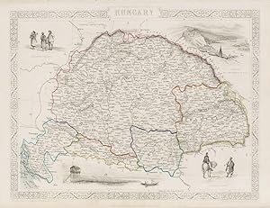
Published by London & New York, John Tallis, 1851
- Art / Print / Poster
Seller: Inanna Rare Books Ltd., Skibbereen, CORK, IrelandInanna Rare Books Ltd.
Contact seller5-star sellerCondition: Used - As new
£ 219.69
£ 23.89 shippingShips from Ireland to U.S.A.Quantity: 1 available
Add to basketCondition: Wie neu. Original steel engraving / Vintage map. Drawn and engraved by John Rapkin. Partly hand-coloured. Illustrations by H.Warren and engravings by J.Rogers. Plate Size: 32 cm x 25.6 cm. Sheet Size: 37.4 cm x 27.4 cm. Vintage 19th century map in very good condition. Published in the Illustrated Atlas, And Modern His…tory Of The World Geographical, Political, Commercial & Statistical, Edited By R. Montgomery Martin. Beautiful and fascinating map of Hungry- also showing the Kingdom's provinces of Croatia, Sclavonia, Banat and Transylvania. To the West lies Austria and to the south are the Ottoman Turks. Its eastern frontiers are mountains, Krapack or Carpathian Mountains to the north and, further south, the Eastern Carpathian Mountains. The Adriatic Sea is squeezed in in the lower left corner of the map. Towns and cities such as Budapest, Munkacs, Leytschan, Szekelyhid, and the Germanic-sounding Grosswarden (Oradea) and Karlsburg (Alba Iulia) are included on the map. Relief is depicted through hachuring. The major rivers, including the Danube, are also shown on the map. A scale-bar is shown near the map's upper decorative border. John Tallis (7 November 1817 3 June 1876) was an English cartographic publisher. His company, John Tallis and Company, published views, maps and atlases in London from roughly 1838 to 1851. Tallis set up as a publisher with Frederick Tallis in Cripplegate in 1842; the business moved to Smithfield in 1846, and was dissolved in 1849. From 1851 to 1854 Tallis operated as John Tallis and Company. He started The illustrated news of the world and national portrait gallery of eminent personages in 1858, selling it for £1,370 in 1861; it folded in 1863. (Wikipedia) The most important project John Tallis undertook, was the 'Illustrated Atlas' from 1851. The original map we offer here, was part of this exceptional Atlas and all the maps it contained are still today considered as the last reminder of an era of lavish map production. Tallis worked the project together with John Rapkin (1815-1876) and it was Rapkin's style and talent that we have to thank for when we marvel at these maps today. What makes these maps so special is the detail of engraved vignettes that surround the map and often show indigenous scenes, people in their environment and even more so, historical buildings or historical views of towns and cities, architecture and landscape. The project of 'The Illustrated Atlas' was designed to be finished just in time for the anxiously awaited "Great Exhibition of the Works of Industry of All Nations" or The Great Exhibition, sometimes referred to as the Crystal Palace Exhibition in reference to the temporary structure in which it was held, was an international exhibition that took place in Hyde Park, London, from 1 May to 11 October 1851. It was the first in a series of World's Fairs, exhibitions of culture and industry that became popular in the 19th century, and it was a much-anticipated event. The Great Exhibition was organized by Henry Cole and Prince Albert, husband of the reigning monarch, Queen Victoria. It was attended by numerous notable figures of the time, including Charles Darwin, Samuel Colt, members of the Orléanist Royal Family and the writers Charlotte Brontë, Charles Dickens, Lewis Carroll, George Eliot and Alfred Tennyson. Music for the opening was under the direction of Sir George Thomas Smart and the continuous music from the exhibited organs for the Queen's procession was "under the superintendence of William Sterndale Bennett". (Wikipedia).
 More images
Western Hemisphere - With Stunning Vignettes of Indigenous Peoples, Native Animals.
Western Hemisphere - Tallis, John / Rapkin, John. (1817 - 1876)
Language: English
Published by London, Edinburgh & Dublin, J.& F. Tallis, 1851
- Art / Print / Poster
Seller: Inanna Rare Books Ltd., Skibbereen, CORK, IrelandInanna Rare Books Ltd.
Contact seller5-star sellerCondition: Used - As new
£ 237.27
£ 23.89 shippingShips from Ireland to U.S.A.Quantity: 1 available
Add to basketCondition: Wie neu. Original steel engraving / Vintage map. Drawn and engraved by John Rapkin. Partly hand-coloured. Illustrations by H. Warren and Enrgaved by J. Rogers. Plate Size: 34 cm x 25.5 cm. Sheet Size: 37.4 cm x 27 cm. In very good condition with only faintest traces of browning to outer margins. Very slight paper impe…rfections along edge. Minor tear near upper left corner. Very minor tear to map above the Arctic Circle. Published in the Illustrated Atlas, And Modern History Of The World Geographical, Political, Commercial & Statistical, Edited By R. Montgomery Martin. Beautifully bordered and fascinating map of the western hemisphere, including North and South America. The Azores and Cape Verde islands and the Caribbean islands are included in the Atlantic Ocean. In the south South Shetland Islands and South Victoria populate a blank area where the Antarctic ought to be found. In the Pacific, New Zealand and the Polynesian and Sandwich (Hawaiian) islands. To the north the end of Asia can be seen and, across the Arctic Ocean, Greenland is also included. The political divisions are colourfully delineated. Interestingly, Alaska is described as 'Russian America' highlighting that the U.S. had still to purchase "Seward's Icebox" from the Tsar when the map was published. John Tallis (7 November 1817 3 June 1876) was an English cartographic publisher. His company, John Tallis and Company, published views, maps and atlases in London from roughly 1838 to 1851. Tallis set up as a publisher with Frederick Tallis in Cripplegate in 1842; the business moved to Smithfield in 1846, and was dissolved in 1849. From 1851 to 1854 Tallis operated as John Tallis and Company. He started The illustrated news of the world and national portrait gallery of eminent personages in 1858, selling it for £1,370 in 1861; it folded in 1863. (Wikipedia) The most important project John Tallis undertook, was the 'Illustrated Atlas' from 1851. The original map we offer here, was part of this exceptional Atlas and all the maps it contained are still today considered as the last reminder of an era of lavish map production. Tallis worked the project together with John Rapkin (1815-1876) and it was Rapkin's style and talent that we have to thank for when we marvel at these maps today. What makes these maps so special is the detail of engraved vignettes that surround the map and often show indigenous scenes, people in their environment and even more so, historical buildings or historical views of towns and cities, architecture and landscape. The project of 'The Illustrated Atlas' was designed to be finished just in time for the anxiously awaited "Great Exhibition of the Works of Industry of All Nations" or The Great Exhibition, sometimes referred to as the Crystal Palace Exhibition in reference to the temporary structure in which it was held, was an international exhibition that took place in Hyde Park, London, from 1 May to 11 October 1851. It was the first in a series of World's Fairs, exhibitions of culture and industry that became popular in the 19th century, and it was a much-anticipated event. The Great Exhibition was organized by Henry Cole and Prince Albert, husband of the reigning monarch, Queen Victoria. It was attended by numerous notable figures of the time, including Charles Darwin, Samuel Colt, members of the Orléanist Royal Family and the writers Charlotte Brontë, Charles Dickens, Lewis Carroll, George Eliot and Alfred Tennyson. Music for the opening was under the direction of Sir George Thomas Smart and the continuous music from the exhibited organs for the Queen's procession was "under the superintendence of William Sterndale Bennett". (Wikipedia).
 More images
Polynesia or Islands in the Pacific Ocean with New Guinea, Caroline Islands, Nippon, New Hebrides, Society Islands, Sandwich Islands with beuatiful Vignettes and illustrations of Kalakakooa, Sandwich Islands (Hawaii), Otaheite, Harbour of Dory, New Guinea, Resolution Bay, Marquesas and the Northwest tip of Australia and California shown in the outskirts of the map.
Asia / Polynesia - Tallis, John / Rapkin, John. (1817 - 1876)
Language: English
Published by London & New York, J & F. Tallis, 1851
- Art / Print / Poster
Seller: Inanna Rare Books Ltd., Skibbereen, CORK, IrelandInanna Rare Books Ltd.
Contact seller5-star sellerCondition: Used - As new
£ 241.66
£ 23.89 shippingShips from Ireland to U.S.A.Quantity: 1 available
Add to basketCondition: Wie neu. Original steel engraving / Vintage map. Drawn and engraved by John Rapkin. Partly hand-coloured. Plate Size: 35.7 cm x 25.8 cm. Sheet Size: 37.5 cm x 27.3 cm. Vintage 19th century map in very good condition. John Tallis (7 November 1817 3 June 1876) was an English cartographic publisher. His company, John Tal…lis and Company, published views, maps and atlases in London from roughly 1838 to 1851. Tallis set up as a publisher with Frederick Tallis in Cripplegate in 1842; the business moved to Smithfield in 1846, and was dissolved in 1849. From 1851 to 1854 Tallis operated as John Tallis and Company. He started The illustrated news of the world and national portrait gallery of eminent personages in 1858, selling it for £1,370 in 1861; it folded in 1863. (Wikipedia) The most important project John Tallis undertook, was the 'Illustrated Atlas' from 1851. The original map we offer here, was part of this exceptional Atlas and all the maps it contained are still today considered as the last reminder of an era of lavish map production. Tallis worked the project together with John Rapkin (1815-1876) and it was Rapkin's style and talent that we have to thank for when we marvel at these maps today. What makes these maps so special is the detail of engraved vignettes that surround the map and often show indigenous scenes, people in their environment and even more so, historical buildings or historical views of towns and cities, architecture and landscape. The project of 'The Illustrated Atlas' was designed to be finished just in time for the anxiously awaited "Great Exhibition of the Works of Industry of All Nations" or The Great Exhibition, sometimes referred to as the Crystal Palace Exhibition in reference to the temporary structure in which it was held, was an international exhibition that took place in Hyde Park, London, from 1 May to 11 October 1851. It was the first in a series of World's Fairs, exhibitions of culture and industry that became popular in the 19th century, and it was a much anticipated event. The Great Exhibition was organized by Henry Cole and Prince Albert, husband of the reigning monarch, Queen Victoria. It was attended by numerous notable figures of the time, including Charles Darwin, Samuel Colt, members of the Orléanist Royal Family and the writers Charlotte Brontë, Charles Dickens, Lewis Carroll, George Eliot and Alfred Tennyson. Music for the opening was under the direction of Sir George Thomas Smart and the continuous music from the exhibited organs for the Queen's procession was "under the superintendence of William Sterndale Bennett". (Wikipedia).
 More images
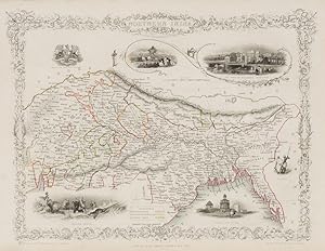
British Guayana with Vignettes of Georgetown, The Christmas Cataract at the River Berbice, Ataraipu or The Devil's Rock / New Amsterdam.
America / South America - Tallis, John / Rapkin, John. (1817 - 1876)
Language: English
Published by London & New York, J & F. Tallis, 1851
- Art / Print / Poster
Seller: Inanna Rare Books Ltd., Skibbereen, CORK, IrelandInanna Rare Books Ltd.
Contact seller5-star sellerCondition: Used - As new
£ 241.66
£ 23.89 shippingShips from Ireland to U.S.A.Quantity: 1 available
Add to basketCondition: Wie neu. Original steel engraving / Vintage map. Drawn and engraved by John Rapkin. Partly hand-coloured. Plate Size: 24.7 cm x 34.7 cm. Sheet Size: 27.4 cm x 37.4 cm. Vintage 19th century map in very good condition. John Tallis (7 November 1817 3 June 1876) was an English cartographic publisher. His company, John Tal…lis and Company, published views, maps and atlases in London from roughly 1838 to 1851. Tallis set up as a publisher with Frederick Tallis in Cripplegate in 1842; the business moved to Smithfield in 1846, and was dissolved in 1849. From 1851 to 1854 Tallis operated as John Tallis and Company. He started The illustrated news of the world and national portrait gallery of eminent personages in 1858, selling it for £1,370 in 1861; it folded in 1863. (Wikipedia) The most important project John Tallis undertook, was the 'Illustrated Atlas' from 1851. The original map we offer here, was part of this exceptional Atlas and all the maps it contained are still today considered as the last reminder of an era of lavish map production. Tallis worked the project together with John Rapkin (1815-1876) and it was Rapkin's style and talent that we have to thank for when we marvel at these maps today. What makes these maps so special is the detail of engraved vignettes that surround the map and often show indigenous scenes, people in their environment and even more so, historical buildings or historical views of towns and cities, architecture and landscape. The project of 'The Illustrated Atlas' was designed to be finished just in time for the anxiously awaited "Great Exhibition of the Works of Industry of All Nations" or The Great Exhibition, sometimes referred to as the Crystal Palace Exhibition in reference to the temporary structure in which it was held, was an international exhibition that took place in Hyde Park, London, from 1 May to 11 October 1851. It was the first in a series of World's Fairs, exhibitions of culture and industry that became popular in the 19th century, and it was a much anticipated event. The Great Exhibition was organized by Henry Cole and Prince Albert, husband of the reigning monarch, Queen Victoria. It was attended by numerous notable figures of the time, including Charles Darwin, Samuel Colt, members of the Orléanist Royal Family and the writers Charlotte Brontë, Charles Dickens, Lewis Carroll, George Eliot and Alfred Tennyson. Music for the opening was under the direction of Sir George Thomas Smart and the continuous music from the exhibited organs for the Queen's procession was "under the superintendence of William Sterndale Bennett". (Wikipedia).
 More images
Venezuela, New Granada, Equador [Ecuador] and the Guayanas with vignettes and illustrations of the Chimborazo, The Fall of the Bagota, Paramaribo (Suriname)
America / South America / Latin America / Venezuela - Tallis, John / Rapkin, John. (1817 - 1876)
Language: English
Published by London & New York, J & F. Tallis, 1851
- Art / Print / Poster
Seller: Inanna Rare Books Ltd., Skibbereen, CORK, IrelandInanna Rare Books Ltd.
Contact seller5-star sellerCondition: Used - As new
£ 241.66
£ 23.89 shippingShips from Ireland to U.S.A.Quantity: 1 available
Add to basketCondition: Wie neu. Original steel engraving / Vintage map. Drawn and engraved by John Rapkin. Partly hand-coloured. Plate Size: 32.7 cm x 24.9 cm. Sheet Size: 37.4 cm x 27.3 cm. Vintage 19th century map in very good condition. John Tallis (7 November 1817 3 June 1876) was an English cartographic publisher. His company, John Tal…lis and Company, published views, maps and atlases in London from roughly 1838 to 1851. Tallis set up as a publisher with Frederick Tallis in Cripplegate in 1842; the business moved to Smithfield in 1846, and was dissolved in 1849. From 1851 to 1854 Tallis operated as John Tallis and Company. He started The illustrated news of the world and national portrait gallery of eminent personages in 1858, selling it for £1,370 in 1861; it folded in 1863. (Wikipedia) The most important project John Tallis undertook, was the 'Illustrated Atlas' from 1851. The original map we offer here, was part of this exceptional Atlas and all the maps it contained are still today considered as the last reminder of an era of lavish map production. Tallis worked the project together with John Rapkin (1815-1876) and it was Rapkin's style and talent that we have to thank for when we marvel at these maps today. What makes these maps so special is the detail of engraved vignettes that surround the map and often show indigenous scenes, people in their environment and even more so, historical buildings or historical views of towns and cities, architecture and landscape. The project of 'The Illustrated Atlas' was designed to be finished just in time for the anxiously awaited "Great Exhibition of the Works of Industry of All Nations" or The Great Exhibition, sometimes referred to as the Crystal Palace Exhibition in reference to the temporary structure in which it was held, was an international exhibition that took place in Hyde Park, London, from 1 May to 11 October 1851. It was the first in a series of World's Fairs, exhibitions of culture and industry that became popular in the 19th century, and it was a much anticipated event. The Great Exhibition was organized by Henry Cole and Prince Albert, husband of the reigning monarch, Queen Victoria. It was attended by numerous notable figures of the time, including Charles Darwin, Samuel Colt, members of the Orléanist Royal Family and the writers Charlotte Brontë, Charles Dickens, Lewis Carroll, George Eliot and Alfred Tennyson. Music for the opening was under the direction of Sir George Thomas Smart and the continuous music from the exhibited organs for the Queen's procession was "under the superintendence of William Sterndale Bennett". (Wikipedia).
 More images
Peru & Bolivia - with Vignettes and illustrations of Lima, Potosi, Tarija, swimming couriers of Peru.
America / South America / Latin America / Bolivia / Peru - Tallis, John / Rapkin, John. (1817 - 1876)
Language: English
Published by London & New York, J & F. Tallis, 1851
- Art / Print / Poster
Seller: Inanna Rare Books Ltd., Skibbereen, CORK, IrelandInanna Rare Books Ltd.
Contact seller5-star sellerCondition: Used - As new
£ 241.66
£ 23.89 shippingShips from Ireland to U.S.A.Quantity: 1 available
Add to basketCondition: Wie neu. Original steel engraving / Vintage map. Drawn and engraved by John Rapkin. Partly hand-coloured. Plate Size: 24.7 cm x 33.8 cm. Sheet Size: 27.4 cm x 37.5 cm. Vintage 19th century map in very good condition. John Tallis (7 November 1817 3 June 1876) was an English cartographic publisher. His company, John Tal…lis and Company, published views, maps and atlases in London from roughly 1838 to 1851. Tallis set up as a publisher with Frederick Tallis in Cripplegate in 1842; the business moved to Smithfield in 1846, and was dissolved in 1849. From 1851 to 1854 Tallis operated as John Tallis and Company. He started The illustrated news of the world and national portrait gallery of eminent personages in 1858, selling it for £1,370 in 1861; it folded in 1863. (Wikipedia) The most important project John Tallis undertook, was the 'Illustrated Atlas' from 1851. The original map we offer here, was part of this exceptional Atlas and all the maps it contained are still today considered as the last reminder of an era of lavish map production. Tallis worked the project together with John Rapkin (1815-1876) and it was Rapkin's style and talent that we have to thank for when we marvel at these maps today. What makes these maps so special is the detail of engraved vignettes that surround the map and often show indigenous scenes, people in their environment and even more so, historical buildings or historical views of towns and cities, architecture and landscape. The project of 'The Illustrated Atlas' was designed to be finished just in time for the anxiously awaited "Great Exhibition of the Works of Industry of All Nations" or The Great Exhibition, sometimes referred to as the Crystal Palace Exhibition in reference to the temporary structure in which it was held, was an international exhibition that took place in Hyde Park, London, from 1 May to 11 October 1851. It was the first in a series of World's Fairs, exhibitions of culture and industry that became popular in the 19th century, and it was a much anticipated event. The Great Exhibition was organized by Henry Cole and Prince Albert, husband of the reigning monarch, Queen Victoria. It was attended by numerous notable figures of the time, including Charles Darwin, Samuel Colt, members of the Orléanist Royal Family and the writers Charlotte Brontë, Charles Dickens, Lewis Carroll, George Eliot and Alfred Tennyson. Music for the opening was under the direction of Sir George Thomas Smart and the continuous music from the exhibited organs for the Queen's procession was "under the superintendence of William Sterndale Bennett". (Wikipedia).
 More images
Brazil - with Vignettes and Illustrations of Boats on the Rio Negro / St.Catharina / Monte Video / Cape St. Antonio in Bahia / Rio de Janeiro.
America / South America / Latin America / Brazil - Tallis, John / Rapkin, John. (1817 - 1876)
Language: English
Published by London & New York, J & F. Tallis, 1851
- Art / Print / Poster
Seller: Inanna Rare Books Ltd., Skibbereen, CORK, IrelandInanna Rare Books Ltd.
Contact seller5-star sellerCondition: Used - As new
£ 241.66
£ 23.89 shippingShips from Ireland to U.S.A.Quantity: 1 available
Add to basketCondition: Wie neu. Original steel engraving / Vintage map. Drawn and engraved by John Rapkin. Partly hand-coloured. Plate Size: 23.9 cm x 34.3 cm. Sheet Size: 27.5 cm x 37.4 cm. Vintage 19th century map in very good condition. John Tallis (7 November 1817 3 June 1876) was an English cartographic publisher. His company, John Tal…lis and Company, published views, maps and atlases in London from roughly 1838 to 1851. Tallis set up as a publisher with Frederick Tallis in Cripplegate in 1842; the business moved to Smithfield in 1846, and was dissolved in 1849. From 1851 to 1854 Tallis operated as John Tallis and Company. He started The illustrated news of the world and national portrait gallery of eminent personages in 1858, selling it for £1,370 in 1861; it folded in 1863. (Wikipedia) The most important project John Tallis undertook, was the 'Illustrated Atlas' from 1851. The original map we offer here, was part of this exceptional Atlas and all the maps it contained are still today considered as the last reminder of an era of lavish map production. Tallis worked the project together with John Rapkin (1815-1876) and it was Rapkin's style and talent that we have to thank for when we marvel at these maps today. What makes these maps so special is the detail of engraved vignettes that surround the map and often show indigenous scenes, people in their environment and even more so, historical buildings or historical views of towns and cities, architecture and landscape. The project of 'The Illustrated Atlas' was designed to be finished just in time for the anxiously awaited "Great Exhibition of the Works of Industry of All Nations" or The Great Exhibition, sometimes referred to as the Crystal Palace Exhibition in reference to the temporary structure in which it was held, was an international exhibition that took place in Hyde Park, London, from 1 May to 11 October 1851. It was the first in a series of World's Fairs, exhibitions of culture and industry that became popular in the 19th century, and it was a much anticipated event. The Great Exhibition was organized by Henry Cole and Prince Albert, husband of the reigning monarch, Queen Victoria. It was attended by numerous notable figures of the time, including Charles Darwin, Samuel Colt, members of the Orléanist Royal Family and the writers Charlotte Brontë, Charles Dickens, Lewis Carroll, George Eliot and Alfred Tennyson. Music for the opening was under the direction of Sir George Thomas Smart and the continuous music from the exhibited organs for the Queen's procession was "under the superintendence of William Sterndale Bennett". (Wikipedia).
 More images
West Canada (South East Ontario with London, Guelph and other cities) with Vignettes and illustrations of Kingston, Falls of Niagara, Lake Erin, Lake Huron, Georgian Bay, Lake Ontario.
America / North America / Canada - Tallis, John / Rapkin, John. (1817 - 1876)
Language: English
Published by London & New York, J & F. Tallis, 1851
- Art / Print / Poster
Seller: Inanna Rare Books Ltd., Skibbereen, CORK, IrelandInanna Rare Books Ltd.
Contact seller5-star sellerCondition: Used - As new
£ 241.66
£ 23.89 shippingShips from Ireland to U.S.A.Quantity: 1 available
Add to basketCondition: Wie neu. Original steel engraving / Vintage map. Drawn and engraved by John Rapkin. Partly hand-coloured. Plate Size: 32.2 cm x 25 cm. Sheet Size: 37.7 cm x 27.2 cm. Vintage 19th century map in very good condition. John Tallis (7 November 1817 3 June 1876) was an English cartographic publisher. His company, John Talli…s and Company, published views, maps and atlases in London from roughly 1838 to 1851. Tallis set up as a publisher with Frederick Tallis in Cripplegate in 1842; the business moved to Smithfield in 1846, and was dissolved in 1849. From 1851 to 1854 Tallis operated as John Tallis and Company. He started The illustrated news of the world and national portrait gallery of eminent personages in 1858, selling it for £1,370 in 1861; it folded in 1863. (Wikipedia) The most important project John Tallis undertook, was the 'Illustrated Atlas' from 1851. The original map we offer here, was part of this exceptional Atlas and all the maps it contained are still today considered as the last reminder of an era of lavish map production. Tallis worked the project together with John Rapkin (1815-1876) and it was Rapkin's style and talent that we have to thank for when we marvel at these maps today. What makes these maps so special is the detail of engraved vignettes that surround the map and often show indigenous scenes, people in their environment and even more so, historical buildings or historical views of towns and cities, architecture and landscape. The project of 'The Illustrated Atlas' was designed to be finished just in time for the anxiously awaited "Great Exhibition of the Works of Industry of All Nations" or The Great Exhibition, sometimes referred to as the Crystal Palace Exhibition in reference to the temporary structure in which it was held, was an international exhibition that took place in Hyde Park, London, from 1 May to 11 October 1851. It was the first in a series of World's Fairs, exhibitions of culture and industry that became popular in the 19th century, and it was a much anticipated event. The Great Exhibition was organized by Henry Cole and Prince Albert, husband of the reigning monarch, Queen Victoria. It was attended by numerous notable figures of the time, including Charles Darwin, Samuel Colt, members of the Orléanist Royal Family and the writers Charlotte Brontë, Charles Dickens, Lewis Carroll, George Eliot and Alfred Tennyson. Music for the opening was under the direction of Sir George Thomas Smart and the continuous music from the exhibited organs for the Queen's procession was "under the superintendence of William Sterndale Bennett". (Wikipedia).
 More images
Language: English
Published by London & New York, J & F. Tallis, 1851
- Art / Print / Poster
Seller: Inanna Rare Books Ltd., Skibbereen, CORK, IrelandInanna Rare Books Ltd.
Contact seller5-star sellerCondition: Used - As new
£ 241.66
£ 23.89 shippingShips from Ireland to U.S.A.Quantity: 1 available
Add to basketCondition: Wie neu. Original steel engraving / Vintage map. Drawn and engraved by John Rapkin. Partly hand-coloured. Plate Size: 33.7 cm x 26 cm. Sheet Size: 37.5 cm x 27.2 cm. Vintage 19th century map in very good condition. John Tallis (7 November 1817 3 June 1876) was an English cartographic publisher. His company, John Talli…s and Company, published views, maps and atlases in London from roughly 1838 to 1851. Tallis set up as a publisher with Frederick Tallis in Cripplegate in 1842; the business moved to Smithfield in 1846, and was dissolved in 1849. From 1851 to 1854 Tallis operated as John Tallis and Company. He started The illustrated news of the world and national portrait gallery of eminent personages in 1858, selling it for £1,370 in 1861; it folded in 1863. (Wikipedia) The most important project John Tallis undertook, was the 'Illustrated Atlas' from 1851. The original map we offer here, was part of this exceptional Atlas and all the maps it contained are still today considered as the last reminder of an era of lavish map production. Tallis worked the project together with John Rapkin (1815-1876) and it was Rapkin's style and talent that we have to thank for when we marvel at these maps today. What makes these maps so special is the detail of engraved vignettes that surround the map and often show indigenous scenes, people in their environment and even more so, historical buildings or historical views of towns and cities, architecture and landscape. The project of 'The Illustrated Atlas' was designed to be finished just in time for the anxiously awaited "Great Exhibition of the Works of Industry of All Nations" or The Great Exhibition, sometimes referred to as the Crystal Palace Exhibition in reference to the temporary structure in which it was held, was an international exhibition that took place in Hyde Park, London, from 1 May to 11 October 1851. It was the first in a series of World's Fairs, exhibitions of culture and industry that became popular in the 19th century, and it was a much anticipated event. The Great Exhibition was organized by Henry Cole and Prince Albert, husband of the reigning monarch, Queen Victoria. It was attended by numerous notable figures of the time, including Charles Darwin, Samuel Colt, members of the Orléanist Royal Family and the writers Charlotte Brontë, Charles Dickens, Lewis Carroll, George Eliot and Alfred Tennyson. Music for the opening was under the direction of Sir George Thomas Smart and the continuous music from the exhibited organs for the Queen's procession was "under the superintendence of William Sterndale Bennett". (Wikipedia).
 More images
Nova Scotia and Newfoundland with Vignettes and illustrations of Halifax, Cod Fishery of Newfoundland. The Vignettes showing Cape Breton and Prince Edward Island, Anticosti Island and the mouth of the St.Lawrence River. The outher margins of the map beautifully illustrate the importance of the Cod Fishery to these regions by showing Cod on hooks. Also on the map a beautiful, large illustration of a Steamship with the fleet of Cod-Fishers behind it.
America / North America / Canada - Tallis, John / Rapkin, John. (1817 - 1876)
Language: English
Published by London & New York, J & F. Tallis, 1851
- Art / Print / Poster
Seller: Inanna Rare Books Ltd., Skibbereen, CORK, IrelandInanna Rare Books Ltd.
Contact seller5-star sellerCondition: Used - As new
£ 241.66
£ 23.89 shippingShips from Ireland to U.S.A.Quantity: 1 available
Add to basketCondition: Wie neu. Original steel engraving / Vintage map. Drawn and engraved by John Rapkin. Partly hand-coloured. Plate Size: 25 cm x 32.5 cm. Sheet Size: 37.5 cm x 27.2 cm. Vintage 19th century map in very good condition. John Tallis (7 November 1817 3 June 1876) was an English cartographic publisher. His company, John Talli…s and Company, published views, maps and atlases in London from roughly 1838 to 1851. Tallis set up as a publisher with Frederick Tallis in Cripplegate in 1842; the business moved to Smithfield in 1846, and was dissolved in 1849. From 1851 to 1854 Tallis operated as John Tallis and Company. He started The illustrated news of the world and national portrait gallery of eminent personages in 1858, selling it for £1,370 in 1861; it folded in 1863. (Wikipedia) The most important project John Tallis undertook, was the 'Illustrated Atlas' from 1851. The original map we offer here, was part of this exceptional Atlas and all the maps it contained are still today considered as the last reminder of an era of lavish map production. Tallis worked the project together with John Rapkin (1815-1876) and it was Rapkin's style and talent that we have to thank for when we marvel at these maps today. What makes these maps so special is the detail of engraved vignettes that surround the map and often show indigenous scenes, people in their environment and even more so, historical buildings or historical views of towns and cities, architecture and landscape. The project of 'The Illustrated Atlas' was designed to be finished just in time for the anxiously awaited "Great Exhibition of the Works of Industry of All Nations" or The Great Exhibition, sometimes referred to as the Crystal Palace Exhibition in reference to the temporary structure in which it was held, was an international exhibition that took place in Hyde Park, London, from 1 May to 11 October 1851. It was the first in a series of World's Fairs, exhibitions of culture and industry that became popular in the 19th century, and it was a much anticipated event. The Great Exhibition was organized by Henry Cole and Prince Albert, husband of the reigning monarch, Queen Victoria. It was attended by numerous notable figures of the time, including Charles Darwin, Samuel Colt, members of the Orléanist Royal Family and the writers Charlotte Brontë, Charles Dickens, Lewis Carroll, George Eliot and Alfred Tennyson. Music for the opening was under the direction of Sir George Thomas Smart and the continuous music from the exhibited organs for the Queen's procession was "under the superintendence of William Sterndale Bennett". (Wikipedia).
 More images
East Canada and New Brunswick with Vignettes and illustrations of Quebec City and a group of Native Americans. The map shows in detail the area between the Bay of Fundy and the St.Lawrence River, to the West it shows reaches as far as Montreal with Trois-Rivières to the North.
America / North America / Canada - Tallis, John / Rapkin, John. (1817 - 1876)
Language: English
Published by London & New York, J & F. Tallis, 1851
- Art / Print / Poster
Seller: Inanna Rare Books Ltd., Skibbereen, CORK, IrelandInanna Rare Books Ltd.
Contact seller5-star sellerCondition: Used - As new
£ 241.66
£ 23.89 shippingShips from Ireland to U.S.A.Quantity: 1 available
Add to basketCondition: Wie neu. Original steel engraving / Vintage map. Drawn and engraved by John Rapkin. Partly hand-coloured. Plate Size: 33.3 cm x 25.5 cm. Sheet Size: 37.5 cm x 27.2 cm. Vintage 19th century map in very good condition. John Tallis (7 November 1817 3 June 1876) was an English cartographic publisher. His company, John Tal…lis and Company, published views, maps and atlases in London from roughly 1838 to 1851. Tallis set up as a publisher with Frederick Tallis in Cripplegate in 1842; the business moved to Smithfield in 1846, and was dissolved in 1849. From 1851 to 1854 Tallis operated as John Tallis and Company. He started The illustrated news of the world and national portrait gallery of eminent personages in 1858, selling it for £1,370 in 1861; it folded in 1863. (Wikipedia) The most important project John Tallis undertook, was the 'Illustrated Atlas' from 1851. The original map we offer here, was part of this exceptional Atlas and all the maps it contained are still today considered as the last reminder of an era of lavish map production. Tallis worked the project together with John Rapkin (1815-1876) and it was Rapkin's style and talent that we have to thank for when we marvel at these maps today. What makes these maps so special is the detail of engraved vignettes that surround the map and often show indigenous scenes, people in their environment and even more so, historical buildings or historical views of towns and cities, architecture and landscape. The project of 'The Illustrated Atlas' was designed to be finished just in time for the anxiously awaited "Great Exhibition of the Works of Industry of All Nations" or The Great Exhibition, sometimes referred to as the Crystal Palace Exhibition in reference to the temporary structure in which it was held, was an international exhibition that took place in Hyde Park, London, from 1 May to 11 October 1851. It was the first in a series of World's Fairs, exhibitions of culture and industry that became popular in the 19th century, and it was a much anticipated event. The Great Exhibition was organized by Henry Cole and Prince Albert, husband of the reigning monarch, Queen Victoria. It was attended by numerous notable figures of the time, including Charles Darwin, Samuel Colt, members of the Orléanist Royal Family and the writers Charlotte Brontë, Charles Dickens, Lewis Carroll, George Eliot and Alfred Tennyson. Music for the opening was under the direction of Sir George Thomas Smart and the continuous music from the exhibited organs for the Queen's procession was "under the superintendence of William Sterndale Bennett". (Wikipedia).
 More images
Language: English
Published by London, Edinburgh & Dublin, J & F. Tallis, 1851
- Art / Print / Poster
Seller: Inanna Rare Books Ltd., Skibbereen, CORK, IrelandInanna Rare Books Ltd.
Contact seller5-star sellerCondition: Used - As new
£ 241.66
£ 23.89 shippingShips from Ireland to U.S.A.Quantity: 1 available
Add to basketCondition: Wie neu. Original steel engraving / Vintage map. Drawn and engraved by John Rapkin. Partly hand-coloured. Illustrations by H. Warren and engravings by J.B. Allen. Plate Size: 25 cm x 34 cm. Sheet Size: 27.4 cm x 37.4 cm. Vintage 19th century map in very good condition. Published in the Illustrated Atlas, And Modern Hi…story Of The World Geographical, Political, Commercial & Statistical, Edited By R. Montgomery Martin. Beautiful and interesting map of Denmark: the Jutland Peninsula and the surrounding islands such as Zealand and Funen in the Baltic and the North Sea. The political subdivisions of Denmark are delineated and the towns and cities, including Copenhagen, Aarhus, and Odense are shown. Off the east coast the Cattegat strait is identified. The southern coast of Sweden is shown as are the German coasts in the lower part of the map (Hanover, Mecklenburg and Prussia) The Danish royal coat-of-arms can be seen in the upper right corner of the map. John Tallis (7 November 1817 3 June 1876) was an English cartographic publisher. His company, John Tallis and Company, published views, maps and atlases in London from roughly 1838 to 1851. Tallis set up as a publisher with Frederick Tallis in Cripplegate in 1842; the business moved to Smithfield in 1846, and was dissolved in 1849. From 1851 to 1854 Tallis operated as John Tallis and Company. He started The illustrated news of the world and national portrait gallery of eminent personages in 1858, selling it for £1,370 in 1861; it folded in 1863. (Wikipedia) The most important project John Tallis undertook, was the 'Illustrated Atlas' from 1851. The original map we offer here, was part of this exceptional Atlas and all the maps it contained are still today considered as the last reminder of an era of lavish map production. Tallis worked the project together with John Rapkin (1815-1876) and it was Rapkin's style and talent that we have to thank for when we marvel at these maps today. What makes these maps so special is the detail of engraved vignettes that surround the map and often show indigenous scenes, people in their environment and even more so, historical buildings or historical views of towns and cities, architecture and landscape. The project of 'The Illustrated Atlas' was designed to be finished just in time for the anxiously awaited "Great Exhibition of the Works of Industry of All Nations" or The Great Exhibition, sometimes referred to as the Crystal Palace Exhibition in reference to the temporary structure in which it was held, was an international exhibition that took place in Hyde Park, London, from 1 May to 11 October 1851. It was the first in a series of World's Fairs, exhibitions of culture and industry that became popular in the 19th century, and it was a much-anticipated event. The Great Exhibition was organized by Henry Cole and Prince Albert, husband of the reigning monarch, Queen Victoria. It was attended by numerous notable figures of the time, including Charles Darwin, Samuel Colt, members of the Orléanist Royal Family and the writers Charlotte Brontë, Charles Dickens, Lewis Carroll, George Eliot and Alfred Tennyson. Music for the opening was under the direction of Sir George Thomas Smart and the continuous music from the exhibited organs for the Queen's procession was "under the superintendence of William Sterndale Bennett". (Wikipedia).
 More images
Language: English
Published by London, The London Printing and Publishing Company, 1851
- Art / Print / Poster
Seller: Inanna Rare Books Ltd., Skibbereen, CORK, IrelandInanna Rare Books Ltd.
Contact seller5-star sellerCondition: Used - As new
£ 241.66
£ 23.89 shippingShips from Ireland to U.S.A.Quantity: 1 available
Add to basketCondition: Wie neu. Original steel engraving / Vintage map. Drawn and engraved by John Rapkin. Illustrated and Engraved by D. Pound. Plate Size: 32 cm x 24 cm. Sheet Size: 37.3 cm x 27.2 cm. Vintage 19th century map / city-plan in very good condition. Published in the Illustrated Atlas, And Modern History Of The World Geographic…al, Political, Commercial & Statistical, Edited By R. Montgomery Martin. Handsome town-plan of Sheffield in South Yorkshire, England. The River Don can be seen running through the city near the top of the map. Railway, street and district areas of the city are also included. Decorative scrolling and title cartouche around the edges of the map. The project of 'The Illustrated Atlas' was designed to be finished just in time for the anxiously awaited "Great Exhibition of the Works of Industry of All Nations" or The Great Exhibition, sometimes referred to as the Crystal Palace Exhibition in reference to the temporary structure in which it was held, was an international exhibition that took place in Hyde Park, London, from 1 May to 11 October 1851. It was the first in a series of World's Fairs, exhibitions of culture and industry that became popular in the 19th century, and it was a much-anticipated event. The Great Exhibition was organized by Henry Cole and Prince Albert, husband of the reigning monarch, Queen Victoria. It was attended by numerous notable figures of the time, including Charles Darwin, Samuel Colt, members of the Orléanist Royal Family and the writers Charlotte Brontë, Charles Dickens, Lewis Carroll, George Eliot and Alfred Tennyson. Music for the opening was under the direction of Sir George Thomas Smart and the continuous music from the exhibited organs for the Queen's procession was "under the superintendence of William Sterndale Bennett". (Wikipedia).
 More images
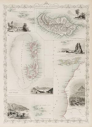
Islands in the Atlantic - Azores or Western Isles - Madeira [Inset] - Canary Islands - Cape de Verde Islands - Bermudas or Summer Islands. With Vignettes and illustrations of Faval, Azores, Chapel in the Rock, St Vincente, Tenerife, Canary Islands and Funchal, Madeira.
Atlantic Islands - Tallis, John / Rapkin, John. (1817 - 1876)
Language: English
Published by London & New York, John Tallis, 1851
- Art / Print / Poster
Seller: Inanna Rare Books Ltd., Skibbereen, CORK, IrelandInanna Rare Books Ltd.
Contact seller5-star sellerCondition: Used - As new
£ 241.66
£ 23.89 shippingShips from Ireland to U.S.A.Quantity: 1 available
Add to basketCondition: Wie neu. Original steel engraving / Vintage map. Drawn and engraved by John Rapkin. Partly hand-coloured. Illustrations drawn and engraved by H. Winkles. Plate Size: 24.5 cm x 36.5 cm. Sheet Size: 27.2 cm x 37.4 cm. Vintage 19th century map in very good condition. Beautiful map with gorgeous illustrated vignettes from… the Victorian publisher. The coast of west Africa can be seen in the lower corner. Relief on Madeira shown with hachuring. Rivers and towns of Madeira also listed. The potentially dangerous waters off Bermuda are highlighted pictorially. The individual names of the Azores, Canary and Cape Verde islands can also be seen. A bar scale lies just under Bermuda. John Tallis (7 November 1817 3 June 1876) was an English cartographic publisher. His company, John Tallis and Company, published views, maps and atlases in London from roughly 1838 to 1851. Tallis set up as a publisher with Frederick Tallis in Cripplegate in 1842; the business moved to Smithfield in 1846, and was dissolved in 1849. From 1851 to 1854 Tallis operated as John Tallis and Company. He started The illustrated news of the world and national portrait gallery of eminent personages in 1858, selling it for £1,370 in 1861; it folded in 1863. (Wikipedia) The most important project John Tallis undertook, was the 'Illustrated Atlas' from 1851. The original map we offer here, was part of this exceptional Atlas and all the maps it contained are still today considered as the last reminder of an era of lavish map production. Tallis worked the project together with John Rapkin (1815-1876) and it was Rapkin's style and talent that we have to thank for when we marvel at these maps today. What makes these maps so special is the detail of engraved vignettes that surround the map and often show indigenous scenes, people in their environment and even more so, historical buildings or historical views of towns and cities, architecture and landscape. The project of 'The Illustrated Atlas' was designed to be finished just in time for the anxiously awaited "Great Exhibition of the Works of Industry of All Nations" or The Great Exhibition, sometimes referred to as the Crystal Palace Exhibition in reference to the temporary structure in which it was held, was an international exhibition that took place in Hyde Park, London, from 1 May to 11 October 1851. It was the first in a series of World's Fairs, exhibitions of culture and industry that became popular in the 19th century, and it was a much anticipated event. The Great Exhibition was organized by Henry Cole and Prince Albert, husband of the reigning monarch, Queen Victoria. It was attended by numerous notable figures of the time, including Charles Darwin, Samuel Colt, members of the Orléanist Royal Family and the writers Charlotte Brontë, Charles Dickens, Lewis Carroll, George Eliot and Alfred Tennyson. Music for the opening was under the direction of Sir George Thomas Smart and the continuous music from the exhibited organs for the Queen's procession was "under the superintendence of William Sterndale Bennett". (Wikipedia).
 More images
Language: English
Published by London, Edinburgh and Dublin, J & F. Tallis, 1851
- Art / Print / Poster
Seller: Inanna Rare Books Ltd., Skibbereen, CORK, IrelandInanna Rare Books Ltd.
Contact seller5-star sellerCondition: Used - As new
£ 241.66
£ 23.89 shippingShips from Ireland to U.S.A.Quantity: 1 available
Add to basketCondition: Wie neu. Original steel engraving / Vintage map. Drawn and engraved by John Rapkin. Partly hand-coloured. Illustrations by A.H. Wray and engraved by J.B Allen. Plate Size: 32.2 cm x 25 cm. Sheet Size : 37.4 cm x 27.3 cm. In very good+ condition with only faintest traces of browning to edges. Slight paper imperfections… to top edge. Very minor smudges to top right corner. Published in the Illustrated Atlas, And Modern History Of The World Geographical, Political, Commercial & Statistical, Edited By R. Montgomery Martin. Beautiful and interesting map of Switzerland with the political subdivisions delineated. The Swiss Cantons such as Vallais, Zurich and Appenzell are all shown. Cities such as Geneva, Basel and Zurich can all be seen. The Swiss rivers and lakes such as Lake Geneva, Neuchatel, and the Bodensee (Lake Constance) are shown on the map. Relief shown pictorially. France, Germany, Austria and Italy are all bordering Switzerland. John Tallis (7 November 1817 3 June 1876) was an English cartographic publisher. His company, John Tallis and Company, published views, maps and atlases in London from roughly 1838 to 1851. Tallis set up as a publisher with Frederick Tallis in Cripplegate in 1842; the business moved to Smithfield in 1846, and was dissolved in 1849. From 1851 to 1854 Tallis operated as John Tallis and Company. He started The illustrated news of the world and national portrait gallery of eminent personages in 1858, selling it for £1,370 in 1861; it folded in 1863. (Wikipedia) The most important project John Tallis undertook, was the 'Illustrated Atlas' from 1851. The original map we offer here, was part of this exceptional Atlas and all the maps it contained are still today considered as the last reminder of an era of lavish map production. Tallis worked the project together with John Rapkin (1815-1876) and it was Rapkin's style and talent that we have to thank for when we marvel at these maps today. What makes these maps so special is the detail of engraved vignettes that surround the map and often show indigenous scenes, people in their environment and even more so, historical buildings or historical views of towns and cities, architecture and landscape. The project of 'The Illustrated Atlas' was designed to be finished just in time for the anxiously awaited "Great Exhibition of the Works of Industry of All Nations" or The Great Exhibition, sometimes referred to as the Crystal Palace Exhibition in reference to the temporary structure in which it was held, was an international exhibition that took place in Hyde Park, London, from 1 May to 11 October 1851. It was the first in a series of World's Fairs, exhibitions of culture and industry that became popular in the 19th century, and it was a much-anticipated event. The Great Exhibition was organized by Henry Cole and Prince Albert, husband of the reigning monarch, Queen Victoria. It was attended by numerous notable figures of the time, including Charles Darwin, Samuel Colt, members of the Orléanist Royal Family and the writers Charlotte Brontë, Charles Dickens, Lewis Carroll, George Eliot and Alfred Tennyson. Music for the opening was under the direction of Sir George Thomas Smart and the continuous music from the exhibited organs for the Queen's procession was "under the superintendence of William Sterndale Bennett". (Wikipedia).
 More images
Falkland Islands and Patagonia - With Vignettes of Jason Islands, Penguins, Sea Eagles, Fugeans, and Christmas Sound, Tierra del Fuego.
South America / Patagonia - Tallis, John / Rapkin, John. (1817 - 1876)
Language: English
Published by London & New York, John Tallis & Company, 1851
- Art / Print / Poster
Seller: Inanna Rare Books Ltd., Skibbereen, CORK, IrelandInanna Rare Books Ltd.
Contact seller5-star sellerCondition: Used - As new
£ 241.66
£ 23.89 shippingShips from Ireland to U.S.A.Quantity: 1 available
Add to basketCondition: Wie neu. Original steel engraving / Vintage map. Drawn and engraved by John Rapkin. Partly hand-coloured. Illustrations by H. Winkles and Engraved by W. Lacey. Plate Size: 25 cm x 35 cm. Sheet Size: 27 cm x 37.4 cm. Vintage 19th century map in very good condition. Two beautiful maps of the Falkland Islands (Islas Malv…inas) and Patagonia bordered by a decorative boundary. In the upper section the islands of the Falkands are shown and identified: West Falkland and East Falkland the chief among them. Hachuring depicts relief and the few rivers shown are identified. A bar-scale lies beneath the islands. In the lower section is Patagonia and the archipelago of Tierra del Fuego, separated from the mainland by the Strait of Magallanes. The names and locations of the indigenous 'wandering tribes of Indians' are shown on the map also: 'Teheul-het' or Southern People, the 'Puel-che' or Eastern People, the 'Chulilon' and 'Moluche' Indians. The plethora of offshore islands, such as Chiloe Island in the Gulf of Ancud in the Pacific, and peninsular points, like the Peninsula of S. Josef on the Atlantic side, are identified. To the east the West Falkand can be seen. A bar-scale is in the lower right corner of the map. John Tallis (7 November 1817 3 June 1876) was an English cartographic publisher. His company, John Tallis and Company, published views, maps and atlases in London from roughly 1838 to 1851. Tallis set up as a publisher with Frederick Tallis in Cripplegate in 1842; the business moved to Smithfield in 1846, and was dissolved in 1849. From 1851 to 1854 Tallis operated as John Tallis and Company. He started The illustrated news of the world and national portrait gallery of eminent personages in 1858, selling it for £1,370 in 1861; it folded in 1863. (Wikipedia) The most important project John Tallis undertook, was the 'Illustrated Atlas' from 1851. The original map we offer here, was part of this exceptional Atlas and all the maps it contained are still today considered as the last reminder of an era of lavish map production. Tallis worked the project together with John Rapkin (1815-1876) and it was Rapkin's style and talent that we have to thank for when we marvel at these maps today. What makes these maps so special is the detail of engraved vignettes that surround the map and often show indigenous scenes, people in their environment and even more so, historical buildings or historical views of towns and cities, architecture and landscape. The project of 'The Illustrated Atlas' was designed to be finished just in time for the anxiously awaited "Great Exhibition of the Works of Industry of All Nations" or The Great Exhibition, sometimes referred to as the Crystal Palace Exhibition in reference to the temporary structure in which it was held, was an international exhibition that took place in Hyde Park, London, from 1 May to 11 October 1851. It was the first in a series of World's Fairs, exhibitions of culture and industry that became popular in the 19th century, and it was a much anticipated event. The Great Exhibition was organized by Henry Cole and Prince Albert, husband of the reigning monarch, Queen Victoria. It was attended by numerous notable figures of the time, including Charles Darwin, Samuel Colt, members of the Orléanist Royal Family and the writers Charlotte Brontë, Charles Dickens, Lewis Carroll, George Eliot and Alfred Tennyson. Music for the opening was under the direction of Sir George Thomas Smart and the continuous music from the exhibited organs for the Queen's procession was "under the superintendence of William Sterndale Bennett". (Wikipedia).
 More images
Language: English
Published by London & New York, John Tallis & Company, 1851
- Art / Print / Poster
Seller: Inanna Rare Books Ltd., Skibbereen, CORK, IrelandInanna Rare Books Ltd.
Contact seller5-star sellerCondition: Used - As new
£ 241.66
£ 23.89 shippingShips from Ireland to U.S.A.Quantity: 1 available
Add to basketCondition: Wie neu. Original steel engraving / Vintage map. Drawn and engraved by John Rapkin. Illustrated and Engraved by H. Winkles. Plate Size: 33 cm x 25 cm. Sheet Size: 37.5 cm x 27 cm. Vintage 19th century map in very good condition. Published in the Illustrated Atlas, And Modern History Of The World Geographical, Politica…l, Commercial & Statistical, Edited By R. Montgomery Martin. Handsome town-plan of Perth, in central Scotland, bordered to the south by the River Tay. Railway, street and district areas of the city are also included. Decorative scrolling and title cartouche around the edges of the image. The project of 'The Illustrated Atlas' was designed to be finished just in time for the anxiously awaited "Great Exhibition of the Works of Industry of All Nations" or The Great Exhibition, sometimes referred to as the Crystal Palace Exhibition in reference to the temporary structure in which it was held, was an international exhibition that took place in Hyde Park, London, from 1 May to 11 October 1851. It was the first in a series of World's Fairs, exhibitions of culture and industry that became popular in the 19th century, and it was a much-anticipated event. The Great Exhibition was organized by Henry Cole and Prince Albert, husband of the reigning monarch, Queen Victoria. It was attended by numerous notable figures of the time, including Charles Darwin, Samuel Colt, members of the Orléanist Royal Family and the writers Charlotte Brontë, Charles Dickens, Lewis Carroll, George Eliot and Alfred Tennyson. Music for the opening was under the direction of Sir George Thomas Smart and the continuous music from the exhibited organs for the Queen's procession was "under the superintendence of William Sterndale Bennett". (Wikipedia).
 More images
Language: English
Published by London & New York, John Tallis & Company, 1851
- Art / Print / Poster
Seller: Inanna Rare Books Ltd., Skibbereen, CORK, IrelandInanna Rare Books Ltd.
Contact seller5-star sellerCondition: Used - As new
£ 241.66
£ 23.89 shippingShips from Ireland to U.S.A.Quantity: 1 available
Add to basketCondition: Wie neu. Original steel engraving / Vintage map. Drawn and engraved by John Rapkin. Partly hand-coloured. Illustrations by A.H. Wray and Engraved by J.H. Kernot. Plate Size: 31.5 cm x 25 cm. Sheet Size: 37.2 cm x 27.2 cm. Vintage 19th century map in very good condition. Beautifully bordered map of northern India, from… Cambay to Chittagong and Aracan in the Bay of Bengal. The political subdivisions are colourfully included marking out independent Nepal and Bhutan. The regions of Jemer, Malwa, Allahabade and Assam can also be seen on the map along with the names of many towns and cities, The regions rivers, including the Ganges, are shown and relief is depicted with hachuring. John Tallis (7 November 1817 3 June 1876) was an English cartographic publisher. His company, John Tallis and Company, published views, maps and atlases in London from roughly 1838 to 1851. Tallis set up as a publisher with Frederick Tallis in Cripplegate in 1842; the business moved to Smithfield in 1846, and was dissolved in 1849. From 1851 to 1854 Tallis operated as John Tallis and Company. He started The illustrated news of the world and national portrait gallery of eminent personages in 1858, selling it for £1,370 in 1861; it folded in 1863. (Wikipedia) The most important project John Tallis undertook, was the 'Illustrated Atlas' from 1851. The original map we offer here, was part of this exceptional Atlas and all the maps it contained are still today considered as the last reminder of an era of lavish map production. Tallis worked the project together with John Rapkin (1815-1876) and it was Rapkin's style and talent that we have to thank for when we marvel at these maps today. What makes these maps so special is the detail of engraved vignettes that surround the map and often show indigenous scenes, people in their environment and even more so, historical buildings or historical views of towns and cities, architecture and landscape. The project of 'The Illustrated Atlas' was designed to be finished just in time for the anxiously awaited "Great Exhibition of the Works of Industry of All Nations" or The Great Exhibition, sometimes referred to as the Crystal Palace Exhibition in reference to the temporary structure in which it was held, was an international exhibition that took place in Hyde Park, London, from 1 May to 11 October 1851. It was the first in a series of World's Fairs, exhibitions of culture and industry that became popular in the 19th century, and it was a much anticipated event. The Great Exhibition was organized by Henry Cole and Prince Albert, husband of the reigning monarch, Queen Victoria. It was attended by numerous notable figures of the time, including Charles Darwin, Samuel Colt, members of the Orléanist Royal Family and the writers Charlotte Brontë, Charles Dickens, Lewis Carroll, George Eliot and Alfred Tennyson. Music for the opening was under the direction of Sir George Thomas Smart and the continuous music from the exhibited organs for the Queen's procession was "under the superintendence of William Sterndale Bennett". (Wikipedia).
 More images
Language: English
Published by London, Edinburgh & Dublin, J & F. Tallis, 1851
- Art / Print / Poster
Seller: Inanna Rare Books Ltd., Skibbereen, CORK, IrelandInanna Rare Books Ltd.
Contact seller5-star sellerCondition: Used - As new
£ 241.66
£ 23.89 shippingShips from Ireland to U.S.A.Quantity: 1 available
Add to basketCondition: Wie neu. Original steel engraving / Vintage map. Drawn and engraved by John Rapkin. Partly hand-coloured. Vignettes by N. Whitlock and Engraved by J. Rogers. Plate Size: 25 cm x 35.5 cm. Sheet Size : 27.1 cm x 37.4 cm. Vintage 19th century map in very good condition. Published in the Illustrated Atlas, And Modern Hist…ory Of The World Geographical, Political, Commercial & Statistical, Edited By R. Montgomery Martin. The last great illustrated map of Scotland in the manner of early tourism maps, dedicated for the being a souvenir for visitors abroad Hunters, etc. Beautiful and interesting map of Scotland including its islands- the Hebrides or Western Isles, Orkney Isles and the more distant Shetland Islands (pictured in inset box in the tope right corner). The northern part of Ireland, England and the Isle of Man are also shown. Scotland's counties, from Wigton in the south to Caithness in the north, are delineated. Rivers and lakes are also shown, and relief shown through hachuring. Bar- scale shown in lower right corner. Ornate bordering. John Tallis (7 November 1817 3 June 1876) was an English cartographic publisher. His company, John Tallis and Company, published views, maps and atlases in London from roughly 1838 to 1851. Tallis set up as a publisher with Frederick Tallis in Cripplegate in 1842; the business moved to Smithfield in 1846, and was dissolved in 1849. From 1851 to 1854 Tallis operated as John Tallis and Company. He started The illustrated news of the world and national portrait gallery of eminent personages in 1858, selling it for £1,370 in 1861; it folded in 1863. (Wikipedia) The most important project John Tallis undertook, was the 'Illustrated Atlas' from 1851. The original map we offer here, was part of this exceptional Atlas and all the maps it contained are still today considered as the last reminder of an era of lavish map production. Tallis worked the project together with John Rapkin (1815-1876) and it was Rapkin's style and talent that we have to thank for when we marvel at these maps today. What makes these maps so special is the detail of engraved vignettes that surround the map and often show indigenous scenes, people in their environment and even more so, historical buildings or historical views of towns and cities, architecture and landscape. The project of 'The Illustrated Atlas' was designed to be finished just in time for the anxiously awaited "Great Exhibition of the Works of Industry of All Nations" or The Great Exhibition, sometimes referred to as the Crystal Palace Exhibition in reference to the temporary structure in which it was held, was an international exhibition that took place in Hyde Park, London, from 1 May to 11 October 1851. It was the first in a series of World's Fairs, exhibitions of culture and industry that became popular in the 19th century, and it was a much-anticipated event. The Great Exhibition was organized by Henry Cole and Prince Albert, husband of the reigning monarch, Queen Victoria. It was attended by numerous notable figures of the time, including Charles Darwin, Samuel Colt, members of the Orléanist Royal Family and the writers Charlotte Brontë, Charles Dickens, Lewis Carroll, George Eliot and Alfred Tennyson. Music for the opening was under the direction of Sir George Thomas Smart and the continuous music from the exhibited organs for the Queen's procession was "under the superintendence of William Sterndale Bennett". (Wikipedia).
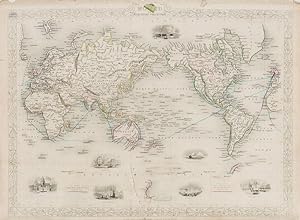 More images
Language: English
Published by London & New York, John Tallis & Company, 1851
- Art / Print / Poster
Seller: Inanna Rare Books Ltd., Skibbereen, CORK, IrelandInanna Rare Books Ltd.
Contact seller5-star sellerCondition: Used - As new
£ 241.66
£ 23.89 shippingShips from Ireland to U.S.A.Quantity: 1 available
Add to basketCondition: Wie neu. Original steel engraving / Vintage map. Drawn and engraved by John Rapkin. Partly hand-coloured. Illustrations by H. Warren and Engraved by J.B. Allen. Plate Size: 34.7 cm x 26.5 cm. Sheet Size: 37.3 cm x 27.2 cm. In fair condition with tears evident. Slight browning and paper imperfections to outer margins.…Published in the Illustrated Atlas, And Modern History Of The World Geographical, Political, Commercial & Statistical, Edited By R. Montgomery Martin. Beautifully bordered and fascinating map of the globe utilizing the Mercator projection that became the usual projection for commercial and educational maps in the 19th Century. Even a cursory glance at the map shows the distortions associated with the map as the lands nearer the equator, such as Africa and South American, look disproportionately small when compared to the inflated sized of Greenland and northern Asia. The lack of knowledge about Antarctica is evident with only a sliver of South Victoria included on the map. Britain's colonial holdings and the steam routes between the UK and its colonies are also included on the map. The major cities and rivers are included on the map and relief depicted with hachuring. The Mercator projection is a cylindrical map projection presented by the Flemish geographer and cartographer Gerardus Mercator in 1569. It became the standard map projection for navigation because of its unique property of representing any course of constant bearing as a straight segment. John Tallis (7 November 1817 3 June 1876) was an English cartographic publisher. His company, John Tallis and Company, published views, maps and atlases in London from roughly 1838 to 1851. Tallis set up as a publisher with Frederick Tallis in Cripplegate in 1842; the business moved to Smithfield in 1846, and was dissolved in 1849. From 1851 to 1854 Tallis operated as John Tallis and Company. He started The illustrated news of the world and national portrait gallery of eminent personages in 1858, selling it for £1,370 in 1861; it folded in 1863. (Wikipedia) The most important project John Tallis undertook, was the 'Illustrated Atlas' from 1851. The original map we offer here, was part of this exceptional Atlas and all the maps it contained are still today considered as the last reminder of an era of lavish map production. Tallis worked the project together with John Rapkin (1815-1876) and it was Rapkin's style and talent that we have to thank for when we marvel at these maps today. What makes these maps so special is the detail of engraved vignettes that surround the map and often show indigenous scenes, people in their environment and even more so, historical buildings or historical views of towns and cities, architecture and landscape. The project of 'The Illustrated Atlas' was designed to be finished just in time for the anxiously awaited "Great Exhibition of the Works of Industry of All Nations" or The Great Exhibition, sometimes referred to as the Crystal Palace Exhibition in reference to the temporary structure in which it was held, was an international exhibition that took place in Hyde Park, London, from 1 May to 11 October 1851. It was the first in a series of World's Fairs, exhibitions of culture and industry that became popular in the 19th century, and it was a much-anticipated event. The Great Exhibition was organized by Henry Cole and Prince Albert, husband of the reigning monarch, Queen Victoria. It was attended by numerous notable figures of the time, including Charles Darwin, Samuel Colt, members of the Orléanist Royal Family and the writers Charlotte Brontë, Charles Dickens, Lewis Carroll, George Eliot and Alfred Tennyson. Music for the opening was under the direction of Sir George Thomas Smart and the continuous music from the exhibited organs for the Queen's procession was "under the superintendence of William Sterndale Bennett". (Wikipedia).
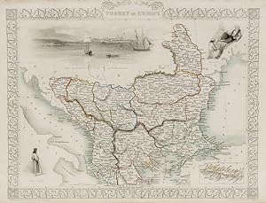 More images
Turkey and Europe - With inset of Island of Cadia and Vignettes of Ali Pasha, Greek Caloyer and the Bosphorus and Constantinople.
Turkey and Balkans - Tallis, John / Rapkin, John. (1817 - 1876)
Language: English
Published by London and New York, J & F. Tallis, 1851
- Art / Print / Poster
Seller: Inanna Rare Books Ltd., Skibbereen, CORK, IrelandInanna Rare Books Ltd.
Contact seller5-star sellerCondition: Used - As new
£ 241.66
£ 23.89 shippingShips from Ireland to U.S.A.Quantity: 1 available
Add to basketCondition: Wie neu. Original steel engraving / Vintage map. Drawn and engraved by John Rapkin. Partly hand-coloured. Illustrations by H. Warren and engraved by J. Rogers. Plate Size: 32.5 cm x 26 cm. Sheet Size : 37.4 cm x 27.3 cm. Vintage 19th century map in very good condition. Published in the Illustrated Atlas, And Modern Hi…story Of The World Geographical, Political, Commercial & Statistical, Edited By R. Montgomery Martin. Beautiful and interesting map of South East Europe. Much of the Balkans was then under the control of the Ottoman Turks. The region is delineated into the historic - and future - nations and states, including Croatia, Herzegovina, Bosnia, Serbia, Albania, Macedonia, northern Greece, Bulgaria, Walachia (in Romania) and Moldova. Russia can be seen extending down into the areas around the Black Sea. Hapsburg-Austria and the heel of the Italian peninsula is shown. Corfu, Cyprus and the Greek islands can be seen lying of the archipelago. Gallipoli, Sea of Marmara, the Bosporus, and Constantinople/Istanbul and Asia Minor/Anatolia are shown in the lower right corner. John Tallis (7 November 1817 3 June 1876) was an English cartographic publisher. His company, John Tallis and Company, published views, maps and atlases in London from roughly 1838 to 1851. Tallis set up as a publisher with Frederick Tallis in Cripplegate in 1842; the business moved to Smithfield in 1846, and was dissolved in 1849. From 1851 to 1854 Tallis operated as John Tallis and Company. He started The illustrated news of the world and national portrait gallery of eminent personages in 1858, selling it for £1,370 in 1861; it folded in 1863. (Wikipedia) The most important project John Tallis undertook, was the 'Illustrated Atlas' from 1851. The original map we offer here, was part of this exceptional Atlas and all the maps it contained are still today considered as the last reminder of an era of lavish map production. Tallis worked the project together with John Rapkin (1815-1876) and it was Rapkin's style and talent that we have to thank for when we marvel at these maps today. What makes these maps so special is the detail of engraved vignettes that surround the map and often show indigenous scenes, people in their environment and even more so, historical buildings or historical views of towns and cities, architecture and landscape. The project of 'The Illustrated Atlas' was designed to be finished just in time for the anxiously awaited "Great Exhibition of the Works of Industry of All Nations" or The Great Exhibition, sometimes referred to as the Crystal Palace Exhibition in reference to the temporary structure in which it was held, was an international exhibition that took place in Hyde Park, London, from 1 May to 11 October 1851. It was the first in a series of World's Fairs, exhibitions of culture and industry that became popular in the 19th century, and it was a much-anticipated event. The Great Exhibition was organized by Henry Cole and Prince Albert, husband of the reigning monarch, Queen Victoria. It was attended by numerous notable figures of the time, including Charles Darwin, Samuel Colt, members of the Orléanist Royal Family and the writers Charlotte Brontë, Charles Dickens, Lewis Carroll, George Eliot and Alfred Tennyson. Music for the opening was under the direction of Sir George Thomas Smart and the continuous music from the exhibited organs for the Queen's procession was "under the superintendence of William Sterndale Bennett". (Wikipedia).
 More images
Language: English
Published by London & New York, The London Printing and Publishing Company, 1851
- Art / Print / Poster
Seller: Inanna Rare Books Ltd., Skibbereen, CORK, IrelandInanna Rare Books Ltd.
Contact seller5-star sellerCondition: Used - As new
£ 241.66
£ 23.89 shippingShips from Ireland to U.S.A.Quantity: 1 available
Add to basketCondition: Wie neu. Original steel engraving / Vintage map. Drawn and engraved by John Rapkin. Illustrated and Engraved by H. Winkles. Plate Size: 32 cm x 25 cm. Sheet Size: 37.3 cm x 27.3 cm. Vintage 19th century map in very good condition. Published in the Illustrated Atlas, And Modern History Of The World Geographical, Politi…cal, Commercial & Statistical, Edited By R. Montgomery Martin. Handsome town-plan of York, in North Yorkshire, England. The River Ouse can be seen running through the city. Railway, street and district areas of the city are also included. Decorative scrolling and title cartouche around the edges of the image. The project of 'The Illustrated Atlas' was designed to be finished just in time for the anxiously awaited "Great Exhibition of the Works of Industry of All Nations" or The Great Exhibition, sometimes referred to as the Crystal Palace Exhibition in reference to the temporary structure in which it was held, was an international exhibition that took place in Hyde Park, London, from 1 May to 11 October 1851. It was the first in a series of World's Fairs, exhibitions of culture and industry that became popular in the 19th century, and it was a much-anticipated event. The Great Exhibition was organized by Henry Cole and Prince Albert, husband of the reigning monarch, Queen Victoria. It was attended by numerous notable figures of the time, including Charles Darwin, Samuel Colt, members of the Orléanist Royal Family and the writers Charlotte Brontë, Charles Dickens, Lewis Carroll, George Eliot and Alfred Tennyson. Music for the opening was under the direction of Sir George Thomas Smart and the continuous music from the exhibited organs for the Queen's procession was "under the superintendence of William Sterndale Bennett". (Wikipedia).
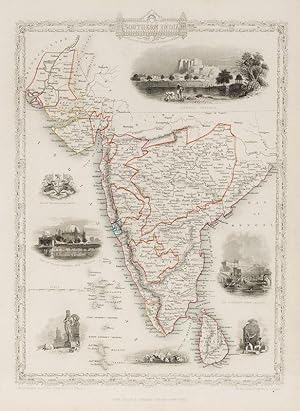 More images
Language: English
Published by London, & New York, John Tallis & Company, 1851
- Art / Print / Poster
Seller: Inanna Rare Books Ltd., Skibbereen, CORK, IrelandInanna Rare Books Ltd.
Contact seller5-star sellerCondition: Used - As new
£ 241.66
£ 23.89 shippingShips from Ireland to U.S.A.Quantity: 1 available
Add to basketCondition: Wie neu. Original steel engraving / Vintage map. Drawn and engraved by John Rapkin. Partly hand-coloured. Illustrations by A.H. Wray and Engraved by J.H. Kernot. Plate Size: 31.8 cm x 25.5 cm. Sheet Size: 37.2 cm x 27.2 cm. Vintage 19th century map in very good condition. Beautiful map of the southern Indian subcontin…ent, from Sinde at the mouth of the Indus Estuary in the north down through Gujerat, Bejapor and Mysore and down into the Carnatic region in the south. Hydrabad and Circars border the Bay of Bengal. Ceylon is also included in the map as are the Laccadive and Maldive islands in the Indian Ocean. Relief is depicting with hachuring. The major cities such as Bombay, Sernigapatam, and Madras are shown, as are the rivers - including the Godavery and Beema rivers. This was an India dominated by the East India Company, the British joint-stock company that came to rule large areas of India with its private armies, exercising military power and seizing administrative functions. Formed in the early 1600s to compete with the Dutch for trade and commerce in the East, the company rose to account for half of the world's trade at one point. Company rule in India lasted until 1858, when, following the Indian Rebellion of 1857, the Government of India Act 1858 led to the British Crown's assuming direct control of the Indian subcontinent in the form of the new British Raj. The company was dissolved in 1874 as a result of the East India Stock Dividend Redemption Act passed one year earlier, as the Government of India Act had by then rendered it vestigial, powerless, and obsolete. The official government machinery of British India assumed the East India Company's governmental functions and absorbed its navy and its armies in 1858. (Wikipedia) John Tallis (7 November 1817 3 June 1876) was an English cartographic publisher. His company, John Tallis and Company, published views, maps and atlases in London from roughly 1838 to 1851. Tallis set up as a publisher with Frederick Tallis in Cripplegate in 1842; the business moved to Smithfield in 1846, and was dissolved in 1849. From 1851 to 1854 Tallis operated as John Tallis and Company. He started The illustrated news of the world and national portrait gallery of eminent personages in 1858, selling it for £1,370 in 1861; it folded in 1863. (Wikipedia) The most important project John Tallis undertook, was the 'Illustrated Atlas' from 1851. The original map we offer here, was part of this exceptional Atlas and all the maps it contained are still today considered as the last reminder of an era of lavish map production. Tallis worked the project together with John Rapkin (1815-1876) and it was Rapkin's style and talent that we have to thank for when we marvel at these maps today. What makes these maps so special is the detail of engraved vignettes that surround the map and often show indigenous scenes, people in their environment and even more so, historical buildings or historical views of towns and cities, architecture and landscape. The project of 'The Illustrated Atlas' was designed to be finished just in time for the anxiously awaited "Great Exhibition of the Works of Industry of All Nations" or The Great Exhibition, sometimes referred to as the Crystal Palace Exhibition in reference to the temporary structure in which it was held, was an international exhibition that took place in Hyde Park, London, from 1 May to 11 October 1851. It was the first in a series of World's Fairs, exhibitions of culture and industry that became popular in the 19th century, and it was a much anticipated event. The Great Exhibition was organized by Henry Cole and Prince Albert, husband of the reigning monarch, Queen Victoria. It was attended by numerous notable figures of the time, including Charles Darwin, Samuel Colt, members of the Orléanist Royal Family and the writers Charlotte Brontë, Charles Dickens, Lewis Carroll, George Eliot and Alfred Tennyson. Music for the opening was under the direction of Sir George Thomas Smart and the continuous music from the exhibited organs for the Queen's procession was "under the superintendence of William Sterndale Bennett". (Wikipedia).
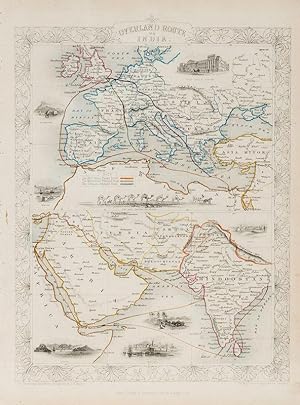 More images
Language: English
Published by London & New York, John Tallis & Company, 1851
- Art / Print / Poster
Seller: Inanna Rare Books Ltd., Skibbereen, CORK, IrelandInanna Rare Books Ltd.
Contact seller5-star sellerCondition: Used - As new
£ 241.66
£ 23.89 shippingShips from Ireland to U.S.A.Quantity: 1 available
Add to basketCondition: Wie neu. Original steel engraving / Vintage map. Drawn and engraved by John Rapkin. Partly hand-coloured. Illustrations by H. Warren and Engraved by J. Rogers. Plate Size: 34.5 cm x 34 cm. Sheet Size: 27.2 cm x 37.4 cm. Vintage 19th century map in very good condition. Published in the Illustrated Atlas, And Modern His…tory Of The World Geographical, Political, Commercial & Statistical, Edited By R. Montgomery Martin. Beautifully bordered and fascinating double map of the overland route between Britain and India. The upper map shows Europe and the links - both land and sea - running from England through to Alexandria, Egypt. The routes are; the 'Mail Steam Packet Route,' which runs around Gibraltar through Malta and onto Egypt; the 'Marseilles Overland Route' that runs across France, to Marseilles and onto Alexandria via Malta and; the 'German Overland Route' that runs through across Belgium, Germany before reaching Trieste and then onto the Mediterranean and then Egypt. The second map shows the differing routes on the next part of the journey - either across the Turkish controlled Middle East and through the Persian Gulf, or down the Red Sea and across the Indian Ocean. What the map clearly illustrates is the importance attached to India ('Hindoostan') in the Imperial mind and the need for secure communication and transport links, which necessitated control of certain choke points on the link such as Gibraltar, Malta, Suez etc. John Tallis (7 November 1817 3 June 1876) was an English cartographic publisher. His company, John Tallis and Company, published views, maps and atlases in London from roughly 1838 to 1851. Tallis set up as a publisher with Frederick Tallis in Cripplegate in 1842; the business moved to Smithfield in 1846, and was dissolved in 1849. From 1851 to 1854 Tallis operated as John Tallis and Company. He started The illustrated news of the world and national portrait gallery of eminent personages in 1858, selling it for £1,370 in 1861; it folded in 1863. (Wikipedia) The most important project John Tallis undertook, was the 'Illustrated Atlas' from 1851. The original map we offer here, was part of this exceptional Atlas and all the maps it contained are still today considered as the last reminder of an era of lavish map production. Tallis worked the project together with John Rapkin (1815-1876) and it was Rapkin's style and talent that we have to thank for when we marvel at these maps today. What makes these maps so special is the detail of engraved vignettes that surround the map and often show indigenous scenes, people in their environment and even more so, historical buildings or historical views of towns and cities, architecture and landscape. The project of 'The Illustrated Atlas' was designed to be finished just in time for the anxiously awaited "Great Exhibition of the Works of Industry of All Nations" or The Great Exhibition, sometimes referred to as the Crystal Palace Exhibition in reference to the temporary structure in which it was held, was an international exhibition that took place in Hyde Park, London, from 1 May to 11 October 1851. It was the first in a series of World's Fairs, exhibitions of culture and industry that became popular in the 19th century, and it was a much-anticipated event. The Great Exhibition was organized by Henry Cole and Prince Albert, husband of the reigning monarch, Queen Victoria. It was attended by numerous notable figures of the time, including Charles Darwin, Samuel Colt, members of the Orléanist Royal Family and the writers Charlotte Brontë, Charles Dickens, Lewis Carroll, George Eliot and Alfred Tennyson. Music for the opening was under the direction of Sir George Thomas Smart and the continuous music from the exhibited organs for the Queen's procession was "under the superintendence of William Sterndale Bennett". (Wikipedia).


