Order Total (1 Item Items):
Shipping Destination:

Wilbrecht (3 results)
Author:
wilbrecht
Refine with Advanced Search
Skip to main search results
Search filters
Product Type
- All Product Types
- Books (2)
- Magazines & Periodicals (No further results match this refinement)
- Comics (No further results match this refinement)
- Sheet Music (No further results match this refinement)
- Art, Prints & Posters (No further results match this refinement)
- Photographs (No further results match this refinement)
- Maps (1)
- Manuscripts & Paper Collectibles (No further results match this refinement)
Condition Learn more
- New (1)
- As New, Fine or Near Fine (1)
- Very Good or Good (No further results match this refinement)
- Fair or Poor (No further results match this refinement)
- As Described (1)
Binding
- All Bindings
- Hardcover (No further results match this refinement)
- Softcover (2)
Collectible Attributes
- First Edition (1)
- Signed (No further results match this refinement)
- Dust Jacket (No further results match this refinement)
- Seller-Supplied Images (1)
- Not Print on Demand (2)
Language (2)
Free Shipping
Seller Location
Seller Rating
-

Patent, betreffend angeordnete Einschreibeprotocolle f�r unaufk�ndbare Staatspapiere, welche an die Direction der Staatsschuld und des sinkenden Fonds eingeliefert werden Kopenhagen, den 4ten April 1835 Placat, angaaende nye indrettede Indskrivings-Protocoller for uopsigelige Statspapirer, der indleveres til Directionen for Statsgjelden og den synkende Fond Kopenhagen, den 4ten April 1835 [gedruckt unterzeichnet mit "Die Direction der Staatsschuld und des sinkenden Fonds, den 4ten April 1835. A.W. Moltke. Holten. L.F. Fog. Johnsen. Hauck. Wilbrecht. J.C.F. Meyer. Holm / Directionen for Statsgjelden og den sinkende Fond, den 4de April 1835."].
Published by Kopenhagen, gedruckt bei Jens Hostrup Schultz, 1835., 1835
Seller: Ganymed - Wissenschaftliches Antiquariat, Meldorf, Germany
Seller rating 5 out of 5 stars

Originaldruck. 8�. 7 Seiten. Ausgabe Jens Hostrup Schultz (1835). Originaldruck. 7 Seiten. Originale Papierbroschur. Guter Zustand. Keine Anstreichungen! Kein Besitzervermerk! Keine Stockflecken! Zweisprachige Ausgabe (deutsch / d�nisch)! SELTEN!!!
-
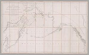
Karta morskikh" otkryt�y ross�yskimi moreplavatelyami na tikhom" i ledovitom" moryakh" v" raznykh" godakh" uchinennykh. . . (Map of maritime discoveries made by Russian navigators in the Pacific and Arctic Oceans in various years. . .)
Published by Map depot (Depo kart), St. Petersburg, 1802
Map First Edition
Condition: Near fine. First. A SUPERLATIVELY RARE 1802 RUSSIAN MAP OF THE BERING STRAIT; THE HECKROTTE COPY, EX COLL. SIR WILLIAM STUART. [St. Petersburg:] Map depot (Depo kart'), 1802. Four sheets joined, dissected into 40 panels and mounted on pale rose linen (30 1/4" x 50 3/4", 765mm x 1285mm). On the verso of the upper-left panel, the octagonal label of Charles Picquet in Paris. Presented in a red straight-grained morocco gilt slipcase with the supralibros gilt of Sir William Stuart (motto above the crest: NOBILIS IRA, below the arms: AVITO VIRET HONORE), with a marbled-paper chemise backed in red straight-grained morocco. On the "spine," "NOUVELLE D�COUVERTE EN AM�RIQUE SEPTENTRIO[N]" gilt to black morocco. A fine example of the map proper, with some wear and blanching at the corners of the linen. Slip-case and chemise rubbed, worn and splitting. A seam (split) to the morocco running right round the slip-case toward the bottom. Spine sunned, with some loss to the lower-right of the label. Alexander Wilbrecht (Aleksandr Vilbrecht, Vilbreht; 1757-1823) was the great Russian cartographer of his day, rising to be chief cartographer to the Imperial Cabinet. From the late 1780's he superintended many of the landmarks of Imperial Russian mapmaking, including the Rossiyskiy atlas (Russian atlas) of 1792 that cemented the provincial reforms of Catherine the Great and the ca. 1796 update reflecting the changes of her son Paul I. His magnum opus was the 1801-1805 Podrobnoy karty Rossiyskoy imperii i blizlezhashchikh zagranichnykh vladeniy (Detailed map of the Russian Empire and of nearby overseas territories), a single map on 114 sheets at a scale of 1:840,000. The present map does not appear to have been part of any of those book projects, but instead a stand-alone map of the northeasternmost part of Russia, across the Bering Strait and into what is now Alaska. Competing claims from Spain, as well as the explorations of Billings, La Perouse, Mackenzie and Vancouver, led to a Russian impulse to map and thereby control the region, no small feat given that the Bering Strait is some 3,600 miles from St. Petersburg. Only two other institutional examples of the map are recorded: at the Library of Congress and at the Biblioth�que nationale de France. The BnF map is part of a larger collection -- from disparate sources -- of 172 maps from the D�p�t de la Marine. (Stanford has digitized the Heckrotte Collection, such that the present map is photographed and described on their site despite its not being in their possession or under their ownership.) Despite its rarity the map is vitally important; Humboldt in his Essai Politique of 1811 refers to it several times, and it was used in the resolution of the 1903 Alaska boundary dispute (pl. 6 in the Alaskan Boundary Tribunal atlas of 1904). The map was sold at the epochal 2015 cartographic sale of Warren Heckrotte (1922-2019; part I, 29 October, lot 198), who, as a physicist at the Lawrence Livermore Laboratory selected to represent the United States in negotiations with the Soviet Union in reaching a treaty to ban nuclear tests, made his first purchase of maps in 1963. Heckrotte -- a careful note-keeper -- records having bought the map from Martayan Lan in April 1992. He then points back to a Francis Edwards catalogue (711, from 1951) in which item 287 "is a large folio atlas, made up of Russian published maps. One of these is 'chart of the Siberian and North American coast, 1802'. This is, I presume, this map. The price for the atlas was �20" (from the PBA lot description). The supralibros are in those of Sir William Stuart (1798-1874). The owner note for Sir William note that the "latter [Sir William] bought many books at the sale of the former [Baron Stuart de Rothesay] and often added his arms to books that had belonged to him, but were without his arms." Sir William's library was sold at Sotheby's 17 June 1875 and at Christie's 6 March 1895.
-

Cars and Stars: Eye-opening, funny and poignant, behind-the-scenes, stories from nearly 40 years of dealing with stars and their cars
Language: English
Published by CreateSpace Independent Publishing Platform, 2012
ISBN 10: 1477475613 ISBN 13: 9781477475614
Paperback. Condition: Brand New. 210 pages. 8.00x0.48x5.00 inches. In Stock. This item is printed on demand.