Order Total (1 Item Items):
Shipping Destination:

Times Bartholomew (72 results)
Skip to main search results
Search filters
Product Type
- All Product Types
- Books (37)
- Magazines & Periodicals (No further results match this refinement)
- Comics (No further results match this refinement)
- Sheet Music (No further results match this refinement)
- Art, Prints & Posters (No further results match this refinement)
- Photographs (No further results match this refinement)
- Maps (35)
- Manuscripts & Paper Collectibles (No further results match this refinement)
Condition Learn more
- New (No further results match this refinement)
- As New, Fine or Near Fine (No further results match this refinement)
- Very Good or Good (66)
- Fair or Poor (No further results match this refinement)
- As Described (6)
Binding
Collectible Attributes
- First Edition (65)
- Signed (No further results match this refinement)
- Dust Jacket (No further results match this refinement)
- Seller-Supplied Images (69)
- Not Print on Demand (72)
Language (2)
Free Shipping
Seller Location
Seller Rating
-
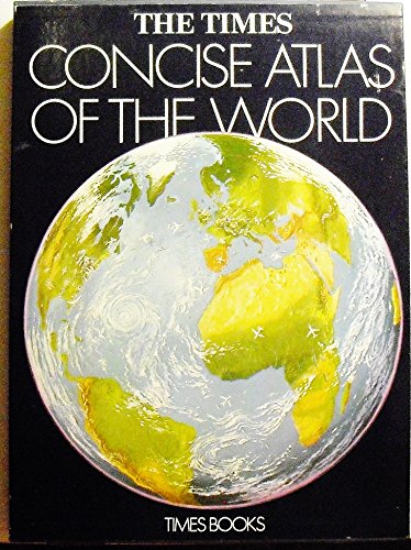
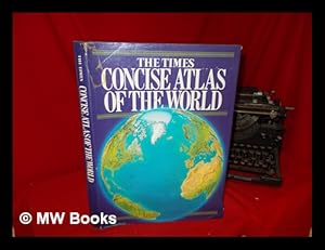
'The Times' Concise Atlas of the World
Language: English
Published by Times Books, New York, 1975
ISBN 10: 0723001405 ISBN 13: 9780723001409
Hard Cover. Condition: Good. No Jacket. Blue cloth boards have faint wear. Pages are clean & text is free from markings. All pages secure in binding. Size: Atlas Folio - over 23" - 25" tall.
-
Later Edition. Good cloth copy in a good if somewhat edge-torn (with some loss) and dust-toned dust-wrapper, now mylar-sleeved. Remains quite well-preserved overall; tight, bright, clean and strong. Physical description; 1 atlas (40, 148, 88 p.) : chiefly col. maps ; 39 cm. Notes; Includes index. ]"Maps prepared and printed in Great Britain by John Bartholomew & Son Limite, Edinburgh.". Subjects; Scales differ. Atlases, British. 1 Kg. Item is Shipped from Ireland or US locations.
-
Map of "Southern Scandinavia & Denmark" from 1920 Times Survey Atlas (Plate 42) including Southern Norway and Sweden, Copenhagen, Goteborg, Malmo, Stockholm, Kristiania, Bergen, Krisiansund, Hernosand, etc.
Published by The Times, London, 1920
Map First Edition
Softcover. Condition: Very Good. Dust Jacket Condition: No Dust Jacket. First Edition. Disbound single sheet with horizontal centre fold from the 1920 "The Times Survey Atlas of the World". Map is in colour and suitable for framing. Colour is according to contour, boundaries of countries and regions are in red. Map at scale 1:2,000,000. Map covers Denmark, southern Norway, southern Sweden and parts of Schleswig-Holstein and Pomerania, towns and cities include Copenhagen, Goteborg, Malmo, Stockholm, Kristiania, Bergen, Krisiansund, Hernosand, etc. Slightly darkened edges with occasional light foxing in margins. Top and bottom edges are a little bumped, sheet is otherwise clean and crisp. Item Type: Map. Single sheet map/chart which is suitable for framing and will be shipped rolled and in a cardboard tube. Quantity Available: 1. Shipped Weight: under 1 kg. Pictures of this item not already displayed here available upon request. Inventory No: 45020034057. All our books are sent by tracked mail.
-
Map of Part of South America including parts of Argentina, Chile, Brazil, Paraguay and Uruguay from the 1920 Times Survey Atlas (Plate 101 Argentina, Chile, &c.)
Published by The Times, London, 1920
Map First Edition
Softcover. Condition: Very Good. Dust Jacket Condition: No Dust Jacket. First Edition. Disbound single sheet with vertical centre fold from the 1920 "The Times Survey Atlas of the World". Map is in colour and suitable for framing. Colour on both land and sea according to contour. Map at scale 1:5,000,000. Map includes parts of countries in South America; Chile from San Pablo in the North to Valdivia in the South, Argentina to Bahia Blanca in the South, Uruguay, Brazil as far North as Rio de Janeiro (shown in inset map) and Paraguay. Also included is the Atlantic Ocean and Pacific Ocean coasts. Slightly darkened edges but sheet is otherwise clean and crisp. Item Type: Map. Single sheet map/chart which is suitable for framing and will be shipped rolled and in a cardboard tube. Quantity Available: 1. Shipped Weight: under 1 kg. Pictures of this item not already displayed here available upon request. Inventory No: 45020034009. All our books are sent by tracked mail.
-
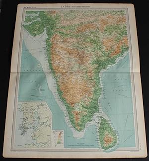
Map of "India - Southern Section" from the 1920 Times Survey Atlas (Plate 58) covering Mysore, Hyrerabad, Central Provinces, Ceylon (Sri Lanka), Kathainwar, Bombay, Baroda, Chota, Laccadive Islands, etc.
Published by The Times, London, 1920
Map First Edition
Softcover. Condition: Very Good. Dust Jacket Condition: No Dust Jacket. First Edition. Disbound single sheet with horizontal centre fold from the 1920 "The Times Survey Atlas of the World". Map is in colour and suitable for framing. Colour on both land and sea according to contour. Map at scale 1:4,000,000 with small inset map of Bombay at scale 1:340,000. Map covers; India (part), Mysore, Hyrerabad, Central Provinces, Ceylon (Sri Lanka), Colombo, Kathainwar, Bombay, Baroda, Chota, Coromandel Coast, Laccadive Islands, Bay of Bengal (part), Gulf of Cambay, Gulf of Manar, Arabian Sea (part), etc. Slightly darkened edges with occasional light foxing or staining in margins but sheet is otherwise clean and crisp. Item Type: Map. Single sheet map/chart which is suitable for framing and will be shipped rolled and in a cardboard tube. Quantity Available: 1. Shipped Weight: under 1 kg. Pictures of this item not already displayed here available upon request. Inventory No: 45020034035. All our books are sent by tracked mail.
-
Softcover. Condition: Very Good. Dust Jacket Condition: No Dust Jacket. First Edition. Disbound single sheet with vertical centre fold from the 1920 "The Times Survey Atlas of the World". Map is in colour and suitable for framing. Colour is according to contour, boundaries of countries and regions are in red. Map at scale 1:1,000,000. Map covers Schwarzwald, Wurtemberg, Franconia, Bavaria, Palatinate, parts of Czecho-Slovakia, Austria, Switzerland and France, cities include Munich, Nurnberg, Salzburg, Pilsen, Frankfurt, Manheim, Wiesbaden, Ulm, Strasbourg, Zurich, Lucerne, Basel, Mulhouse, Stuttgart, Karlsruhe, Bern, etc. Slightly darkened edges with foxing in margins, sheet is otherwise clean and crisp. Item Type: Map. Single sheet map/chart which is suitable for framing and will be shipped rolled and in a cardboard tube. Quantity Available: 1. Shipped Weight: under 1 kg. Pictures of this item not already displayed here available upon request. Inventory No: 45020034056. All our books are sent by tracked mail.
-
Map of Manitoba and North-West Ontario, Canada from the 1920 Times Survey Atlas (Plate 87)
Published by The Times, London, 1920
Map First Edition
Softcover. Condition: Very Good. Dust Jacket Condition: No Dust Jacket. First Edition. Disbound single sheet with vertical centre fold from the 1920 "The Times Survey Atlas of the World". Map is in colour and suitable for framing. Colour according to contour. Map at scale 1:2,500,000. Map covers; Manitora (as far north as Clearwater Lake only), Ontario (part), North Dakota (part), Minnesota (part), Lake Winnipeg, Lake Superior, Lake Nipigon, Brandon, Winnipeg, Fort William, Sault Ste Marie, Albany River, Duluth, etc. Slightly darkened edges with very occasional light foxing in margins but sheet is otherwise clean and crisp. Item Type: Map. Single sheet map/chart which is suitable for framing and will be shipped rolled and in a cardboard tube. Quantity Available: 1. Shipped Weight: under 1 kg. Pictures of this item not already displayed here available upon request. Inventory No: 45020034020. All our books are sent by tracked mail.
-
Map of British Columbia, Canada from the 1920 Times Survey Atlas (Plate 89) including part of Alberta, Vancouver Island, Queen Charlotte Islands and Prince of Wales Island etc.
Published by The Times, London, 1920
Map First Edition
Softcover. Condition: Very Good. Dust Jacket Condition: No Dust Jacket. First Edition. Disbound single sheet with vertical centre fold from the 1920 "The Times Survey Atlas of the World". Map is in colour and suitable for framing. Colour on both land and sea according to contour. Map at scale 1:2,500,000. Map covers; British Columbia (as far North as Zarembo Island), Alberta (part), Rocky Mountains, Vancouver Island, US Border, Washington (part), Idaho (part), Montana (part), Calgary, Edmonton, Lesser Slave Lake, Graham Island, Hecate Strait, Strait of Juan de Fuca, Fraser River, etc. Sheet contains small inset map of Vancouver and New Westminster at 1:500,000. Slightly darkened edges and occasional light foxing in margins but sheet is otherwise clean and crisp. Item Type: Map. Single sheet map/chart which is suitable for framing and will be shipped rolled and in a cardboard tube. Quantity Available: 1. Shipped Weight: under 1 kg. Pictures of this item not already displayed here available upon request. Inventory No: 45020034018. All our books are sent by tracked mail.
-
Map of Alberta and Saskatchewan, Canada from the 1920 Times Survey Atlas (Plate 88) including part of Manitoba
Published by The Times, London, 1920
Map First Edition
Softcover. Condition: Very Good. Dust Jacket Condition: No Dust Jacket. First Edition. Disbound single sheet with vertical centre fold from the 1920 "The Times Survey Atlas of the World". Map is in colour and suitable for framing. Colour according to contour. Map at scale 1:2,500,000. Map covers; Alberta (part), Saskatchewan (as far north as Frobisher Lake only), Manitoba (part), Lake Winnipeg (part), USA Border, Montanna (part), North Dakota (part), Edmonton, Calgary, Rocky Mountains (part), Regina, Saskatoon, Brandon, etc. Slightly darkened edges but sheet is otherwise clean and crisp. Item Type: Map. Single sheet map/chart which is suitable for framing and will be shipped rolled and in a cardboard tube. Quantity Available: 1. Shipped Weight: under 1 kg. Pictures of this item not already displayed here available upon request. Inventory No: 45020034019. All our books are sent by tracked mail.
-
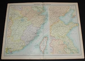
Map of Eastern China from the 1920 Times Survey Atlas (Plate 64) including Hankow, Anking, Nanking, Hangchow, Shanghai, Ningpo, Foochow, Canton, Hong Kong, Peking, Tientsin, Tsinan, Amoy and Taiwan (Formosa)
Published by The Times, London, 1920
Map First Edition
Softcover. Condition: Very Good. Dust Jacket Condition: No Dust Jacket. First Edition. Disbound single sheet with vertical centre fold from the 1920 "The Times Survey Atlas of the World". Map is in colour and suitable for framing. Province boundaries are marked in different colours with colour infill in matching paler colours, seas are coloured blue. Map at scale 1:3,000,000 and split over two continuation panels. Map covers Kiangsi, Anhwei, Shantung, Fukien, Kwangtung, Chekiang, Chinli, Kiangsu, Hankow, Anking, Nanking, Hangchow, Shanghai, Ningpo, Foochow, Canton, Hong Kong, Peking, Tientsin, Tsinan, Amoy, Taiwan (Formosa), Gulf of Pechihli, Gulf og Liaotung, etc. Slightly darkened edges with occasional light foxing in margins, sheet is otherwise clean and crisp. Item Type: Map. Single sheet map/chart which is suitable for framing and will be shipped rolled and in a cardboard tube. Quantity Available: 1. Shipped Weight: under 1 kg. Pictures of this item not already displayed here available upon request. Inventory No: 45020034043. All our books are sent by tracked mail.
-
Map of "Germany - Western Section" from 1920 Times Atlas (Plate 40) including Hamburg, Lubeck, Bremen, Essen, Hanover, Brunswick, Magdeburg, Cologne, Dusseldorf, Erfurt, Cassel, Weimar, Coblenz and Kiel
Published by The Times, London, 1920
First Edition
Softcover. Condition: Very Good. Dust Jacket Condition: No Dust Jacket. First Edition. Disbound single sheet with horizontal centre fold from the 1920 "The Times Survey Atlas of the World". Map is in colour and suitable for framing. Colour is according to contour, boundaries of countries and regions/states are in red. Map at scale 1:1,000,000. Map covers Schleswig-Holstein, Oldenburg, Hanover, Westphalia, Hessen, Heliogoland Bay, East Frisian Islands, Mecklenburg Bay, etc. and part of Holland and the Denmark border. Cities include Hamburg, Lubeck, Bremen, Essen, Hanover, Brunswick, Magdeburg, Cologne, Dusseldorf, Erfurt, Cassel, Weimar, Coblenz and Kiel, Groningen, etc. Sheet includes small inset plan of Berlin. Slightly darkened and worn edges with foxing in margins, sheet is otherwise clean, bright and crisp. Size: 58cm x 46cm approx. Quantity Available: 1. Shipped Weight: under 1 kg. Pictures of this item not already displayed here available upon request. Inventory No: 45020044043. All our books are sent by tracked mail.
-
Map of "Scotland - Southern Section" from the 1920 Times Atlas (Plate 21) covering Solway Firth to Montrose including Glasgow, Endinburgh, Arran, Mull, Carlisle, Durham and Belfast
Published by The Times, London, 1920
First Edition
Softcover. Condition: Very Good. Dust Jacket Condition: No Dust Jacket. First Edition. Disbound single sheet with vertical centre fold from the 1920 "The Times Survey Atlas of the World". Map is in colour and is suitable for framing. Colour on both land and sea according to contour. Map at scale 1:633,600. Map covers southern Scotland, Firth of Clyde, Solway Firth, Firth of Forth, Northumberland, Durham, Cumberland and Antrim (Northern Ireland) and includes Rathlin Island, Belfast, Carlisle, Durham, Newcastle, Berwick, Dumfries, Ayr, Glasgow, Edinburgh, Stirling, Montrose, Argyll, Null, Arran, Jura, Islay, etc. Slightly darkened and worn edges with some light foxing in the margins. Top edge is a little more bumped and darkened than the rest, sheet is otherwise clean and bright. Size: 46cm x 58cm approx. Quantity Available: 1. Shipped Weight: under 1 kg. Pictures of this item not already displayed here available upon request. Inventory No: 45020044027. All our books are sent by tracked mail.
-
Map of "Southern Italy" from 1920 Times Atlas (Plate 37) including Sardinia, Sicily, Malta and Tunis
Published by The Times, London, 1920
First Edition
Softcover. Condition: Very Good. Dust Jacket Condition: No Dust Jacket. First Edition. Disbound single sheet with vertical centre fold from the 1920 "The Times Survey Atlas of the World". Map is in colour and suitable for framing. Colour is according to contour, boundaries of countries or regions are in red. Map at scale 1:2,000,000 with small inset maps of Rome and the Bay of Naples at 1:500,000. Map covers southern Italy, the southern half of Corsica, Sardinia, Sicily, Malta and parts of Corfu, Albania and Tunisia. Map includes Rome, Naples, Lecce, Scutari, Messina, Palermo, Catania, Valetta, Gozo, Tunis and Cagliari along with Etna and Versuvius. Slightly darkened edges with occasional very light foxing in margins and along centre fold. Sheet is otherwise clean and bright. Size: 46cm x 58cm approx. Quantity Available: 1. Shipped Weight: under 1 kg. Pictures of this item not already displayed here available upon request. Inventory No: 45020044005. All our books are sent by tracked mail.
-
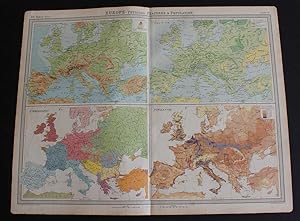
Maps of Europe showing Orography, Vegetation, Ethnography and Population from the 1920 Times Atlas (Plate 11 "Europe - Physical Features & Population") - single sheet containing 4 maps
Published by The Times, London, 1920
First Edition
Softcover. Condition: Very Good. Dust Jacket Condition: No Dust Jacket. First Edition. Disbound single sheet with vertical centre fold from the 1920 "The Times Survey Atlas of the World". Sheet is subdivided into four maps - Orography, Vegetation, Ethnography and Population. Maps are in colour and sheet is suitable for framing. Sheet has slightly darkened and worn edges with occasional light foxing. Sheet is otherwise clean, crisp and bright. Size: 46cm x 58cm approx. Quantity Available: 1. Shipped Weight: under 1 kg. Pictures of this item not already displayed here available upon request. Inventory No: 45020044036. All our books are sent by tracked mail.
-
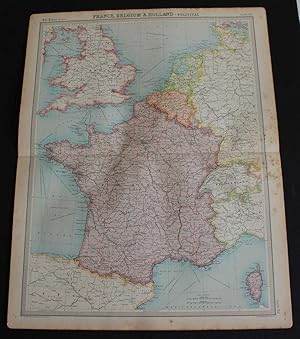
Softcover. Condition: Good. Dust Jacket Condition: No Dust Jacket. First Edition. Disbound single sheet with horizontal centre fold from the 1920 "The Times Survey Atlas of the World". Map is in colour and suitable for framing. Colour is according to country, France, Belgium and Holland are fully coloured, others only have coloured borders. Map at scale 1:3,000,000. Map covers France, Belgium, Holland, England, Wales, Switzerland (almost all), Andorra, Luxemburg, Corsica, Channel Islands, Isle of Man, Liechtenstein and parts of Germany, Italy, Spain, Scotland, Ireland and Denmark. Slightly darkened and worn edges with some light foxing in the margins and heavier foxing along the right hand edge which extends slightly into the mapped area. Sheet is otherwise crisp, clean and bright. Size: 58cm x 46cm approx. Quantity Available: 1. Shipped Weight: under 1 kg. Pictures of this item not already displayed here available upon request. Inventory No: 45020044013. All our books are sent by tracked mail.
-
Softcover. Condition: Very Good. Dust Jacket Condition: No Dust Jacket. First Edition. Disbound single sheet with vertical centre fold from the 1920 "The Times Survey Atlas of the World". Map is in colour and suitable for framing. Colour is according to contour, boundaries of departments are in red. Map at scale 1:1,000,000 with small inset plans of Paris, Le Havre and Brest. Map covers the north western departments of France and includes the Channel Islands, Paris, Rouen, Le Havre, Rennes, Le Mans, Brest, Nantes, Angers, Tours, Poitiers, Amiens, Dieppe, Orleans, Cherbourg, Quimper, La Roche, Chateauroux, etc. Slightly darkened edges with occasional very light foxing in the margins. Sheet is otherwise crisp, clean and bright. Size: 46cm x 58cm approx. Quantity Available: 1. Shipped Weight: under 1 kg. Pictures of this item not already displayed here available upon request. Inventory No: 45020044006. All our books are sent by tracked mail.
-
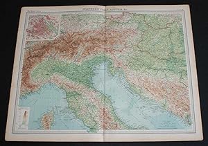
Map of "Northern Italy, Austria, etc." from 1920 Times Atlas (Plate 36) including Turin, Milan, Verona, Trieste, Venice, Florence, Ravenna, Bologna, Rome, Munich, Vienna, Budapest, Salzberg, Elba, etc.
Published by The Times, London, 1920
First Edition
Softcover. Condition: Very Good. Dust Jacket Condition: No Dust Jacket. First Edition. Disbound single sheet with vertical centre fold from the 1920 "The Times Survey Atlas of the World". Map is in colour and suitable for framing. Colour is according to contour, boundaries of countries or regions are in red. Map at scale 1:2,000,000 with small inset plan of Vienna at 1:150,000. Map covers northern Italy, the northern half of Corsica, Austria, Liechtenstein,and parts of modern day Croatia, Slovenia, Bosnia and Herzegovina, Hungary, Montenegro, Germany, Switzerland and Slovakia. Map includes Turin, Milan, Verona, Trieste, Venice, Florence, Ravenna, Bologna, Rome, Munich, Vienna, Budapest, Salzberg, Elba, and parts of the Ligurian and Adriatic Seas, etc. Slightly darkened edges with occasional light foxing in margins and along centre fold. Edges at bottom corners are very slightly roughened. Sheet is otherwise clean, crisp and bright. Size: 46cm x 58cm approx. Quantity Available: 1. Shipped Weight: under 1 kg. Pictures of this item not already displayed here available upon request. Inventory No: 45020044004. All our books are sent by tracked mail.
-
World Vegetation and Ocean Currents Map from the 1920 Times Atlas (Plate 4)
Published by The Times, London, 1920
First Edition
Softcover. Condition: Very Good. Dust Jacket Condition: No Dust Jacket. First Edition. Disbound single sheet with vertical centre fold from the 1920 "The Times Survey Atlas of the World". Map is in colour and sheet is suitable for framing. Colour on land is by vegetation type and on sea is by temperature of current. Arrows indicate Ocean Currents. Sheet also contains "Vertical Distribution of Vegetation" diagrams for; North America, Europe, Asia, South America, Africa and Australia and New Zealand. Sheet has slightly darkened and worn edges with occasional light foxing. Sheet is otherwise clean and bright. Size: 46cm x 58cm approx. Quantity Available: 1. Shipped Weight: under 1 kg. Pictures of this item not already displayed here available upon request. Inventory No: 45020044033. All our books are sent by tracked mail.
-
Vegetation and Climate (Rainfall and Temperature) Map of the British Isles from the 1920 Times Atlas (Plate 15)
Published by The Times, London, 1920
First Edition
Softcover. Condition: Very Good. Dust Jacket Condition: No Dust Jacket. First Edition. Disbound single sheet with horizontal centre fold from the 1920 "The Times Survey Atlas of the World". Sheet is divided into 7 panels. Main vegetation map covers whole of British Isles at scale 1:3,000,000 with the Shetland Islands included in an inset continuation panel. Down the left hand side are three smaller temperature maps (January, July and Actual Annual) and down the right are three rainfall maps (January, July and Mean Annual). Map is in colour and suitable for framing. Slightly darkened edges with occasional very light foxing in the margins. Sheet is otherwise crisp and clean. Size: 46cm x 58cm approx. Quantity Available: 1. Shipped Weight: under 1 kg. Pictures of this item not already displayed here available upon request. Inventory No: 45020044021. All our books are sent by tracked mail.
-
Softcover. Condition: Very Good. Dust Jacket Condition: No Dust Jacket. First Edition. Disbound single sheet with horizontal centre fold from the 1920 "The Times Survey Atlas of the World". Map is in colour and suitable for framing. Colour is according to contour, boundaries of departments and countries are in red. Map at scale 1:1,000,000 with Corse/Corsica included in inset panel and small inset plan of Marseille. Map covers south eastern departments of France, Corsica and parts of Switzerland and Italy. Included are Marseille, Lyon, St Etienne, Nice, Cleremont, Perpignan, Toulon, Beziers, Montpellier, Nimes, Avignon, Cannes, Geneva, Lausanne, Matterhorn, Grenoble and Turin, etc. Slightly darkened edges with occasional foxing in the margins and around the Golfe du Lion. Edges are slightly worn and bumped but sheet is otherwise crisp and clean. Size: 58cm x 46cm approx. Quantity Available: 1. Shipped Weight: under 1 kg. Pictures of this item not already displayed here available upon request. Inventory No: 45020044009. All our books are sent by tracked mail.
-
World Maps showing Commerce from the 1920 Times Atlas (Plate 6) - single sheet containing 3 maps; Commercial Development, Occupations and Means of Traffic
Published by The Times, London, 1920
First Edition
Softcover. Condition: Very Good. Dust Jacket Condition: No Dust Jacket. First Edition. Disbound single sheet with vertical centre fold from the 1920 "The Times Survey Atlas of the World". Sheet is subdivided into three maps. Maps are in colour and sheet is suitable for framing. Largest map shows "Commercial Development". Colouring on sea shows Seas open to navigation all year round and those only navigable in summer. Colouring on land indicates Regions engaged in International Commerce, those with potential to be, Regions only open to Commerce in the Summer Months and Barren or Desert Regions Incaperble of Commercial Development. Two smaller maps show "Occupations" globally (Hunting, Fishing and Collecting, Primative Agriculture, Agriculture, Stock Rearing, Mining, Manufacturing and Fisheries) and "Means of Traffic" (Railway, Horse and Mule, Dog and Reindeer Sledges, Camel and Horse, Ox, Llama, Yak, Human Carriage). Sheet has slightly darkened and worn edges with occasional light foxing. Sheet is otherwise clean, crisp and bright. Size: 46cm x 58cm approx. Quantity Available: 1. Shipped Weight: under 1 kg. Pictures of this item not already displayed here available upon request. Inventory No: 45020044035. All our books are sent by tracked mail.
-
Softcover. Condition: Very Good. Dust Jacket Condition: No Dust Jacket. First Edition. Disbound single sheet with vertical centre fold from the 1920 "The Times Survey Atlas of the World". Map is in colour and suitable for framing. Colour on both land and sea according to contour with borders marked in red. Map at scale 1:5,000,000. Map covers; Ivory Coast, Liberia, Gold Coast Colony, Dahomey, Upper Volta, Upper Senegal and Niger, French Guinea, French West Africa (part), Sierra Leone, Gambia, Portuguese Guinea, Mauritania (part), Nigeria (part), Bight of Benin, etc. Slightly darkened edges with occasional light foxing in margins but sheet is otherwise clean and crisp. Item Type: Map. Single sheet map/chart which is suitable for framing and will be shipped rolled and in a cardboard tube. Quantity Available: 1. Shipped Weight: under 1 kg. Pictures of this item not already displayed here available upon request. Inventory No: 45020034033. All our books are sent by tracked mail.
-
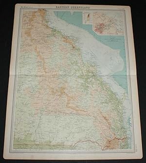
Map of Eastern Queensland, Australia from the 1920 Times Survey Atlas (Plate 109) including inset map of Brisbane and Environs
Published by The Times, London, 1920
Map First Edition
Softcover. Condition: Very Good. Dust Jacket Condition: No Dust Jacket. First Edition. Disbound single sheet with horizontal centre fold from the 1920 "The Times Survey Atlas of the World". Map is in colour and suitable for framing. Colour on both land and sea according to contour. Map at scale 1:2,500,000 with inset of Brisbane at larger scale. Area covered includes: Innisfail, Tate, Numalla, Bentinck, Brisbane, Maryborough, Great Sandy Island, Northumberland Isles, Palm Isles, Gladstone, Mackay, Townsville, Great Dividing Range, Denham Range, Great Barrier Reef (part), etc. Slightly darkened edges and very occasional foxing but sheet is otherwise clean and crisp. Item Type: Map. Single sheet map/chart which is suitable for framing and will be shipped rolled and in a cardboard tube. Quantity Available: 1. Shipped Weight: under 1 kg. Pictures of this item not already displayed here available upon request. Inventory No: 45020034004. All our books are sent by tracked mail.
-
Map of South Australia from the 1920 Times Survey Atlas (Plate 110) including inset map of Adelaide and Environs
Published by The Times, London, 1920
Map First Edition
Softcover. Condition: Very Good. Dust Jacket Condition: No Dust Jacket. First Edition. Disbound single sheet with horizontal centre fold from the 1920 "The Times Survey Atlas of the World". Map is in colour and suitable for framing. Colour on both land and sea according to contour. Map at scale 1:2,500,000 with inset of Adelaide at larger scale. Area covered includes: Lake Eyre, Lake Torrens, Lake Frome, Lake Gairdner, Spencer Gulf, Carnarvon or Kangaroo Island, Gulf of St. Vincent, Adelaide, Stuarts Range, etc. Slightly darkened edges, sheet some foxing in the margins and has occasional light foxing in the mapped area but is otherwise clean and crisp. Item Type: Map. Single sheet map/chart which is suitable for framing and will be shipped rolled and in a cardboard tube. Quantity Available: 1. Shipped Weight: under 1 kg. Pictures of this item not already displayed here available upon request. Inventory No: 45020034003. All our books are sent by tracked mail.
-
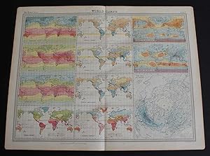
World Climate Maps from the 1920 Times Atlas (Plate 3) - single sheet containing 11 small maps depicting World Temperature levels, Rainfall and Pressure and Winds
Published by The Times, London, 1920
First Edition
Softcover. Condition: Very Good. Dust Jacket Condition: No Dust Jacket. First Edition. Disbound single sheet with vertical centre fold from the 1920 "The Times Survey Atlas of the World". Maps are in colour and sheet is suitable for framing. Sheet is divided into 11 panels which show information on: World Temperatures (January, July, Annual); Thermal Regions; World Rainfall (January, July, Mean Annual, Seasonal); Pressure and Winds (January, July); Storm Tracks and Frequency (centring on the North Pole). Slightly darkened and worn edges with occasional light foxing and slight creases in the margins. Sheet is otherwise clean and bright. Size: 46cm x 58cm approx. Quantity Available: 1. Shipped Weight: under 1 kg. Pictures of this item not already displayed here available upon request. Inventory No: 45020044032. All our books are sent by tracked mail.
-
Map of "Germany - Eastern Section" from 1920 Times Atlas (Plate 41) including Berlin, Magdeburg, Leipzip, Dresden, Chemnitz, Halle, Breslau, Posen, Stettin, Stralsund, Gorlitz, Liegnitz, Dessau, etc.
Published by The Times, London, 1920
First Edition
Softcover. Condition: Very Good. Dust Jacket Condition: No Dust Jacket. First Edition. Disbound single sheet with horizontal centre fold from the 1920 "The Times Survey Atlas of the World". Map is in colour and suitable for framing. Colour is according to contour, boundaries of countries and regions/states are in red. Map at scale 1:1,000,000. Map coversSchleswig-Holstein, Oldenburg, Hanover, Westphalia, Hessen, Prussia, Heliogoland Bay, East Frisian Islands, Mecklenburg Bay, etc. and part of Holland and the Denmark border. Cities include Hamburg, Lubeck, Bremen, Essen, Hanover, Brunswick, Magdeburg, Cologne, Dusseldorf, Erfurt, Cassel, Weimar, Coblenz and Kiel, Groningen, etc. Sheet includes small inset plan of Berlin. Slightly darkened and worn edges with foxing in margins, sheet is otherwise clean, bright and crisp. Size: 58cm x 46cm approx. Quantity Available: 1. Shipped Weight: under 1 kg. Pictures of this item not already displayed here available upon request. Inventory No: 45020044044. All our books are sent by tracked mail.
-
Softcover. Condition: Very Good. Dust Jacket Condition: No Dust Jacket. First Edition. Disbound single sheet with vertical centre fold from the 1920 "The Times Survey Atlas of the World". Map is in colour and suitable for framing. Colour is according to contour, boundaries of departments and countries are in red. Map at scale 1:1,000,000. Map covers the north eastern departments of France and parts of Belgium, Germany and Switzerland and includes Paris, Orleans, Moulins, Nevers, Troyes, Riems, Nancy, Metz, Dijon, Strasbourg, Mulhouse, Besancon, Luxemburg, Mannheim, Basel, Bern, etc. Slightly darkened edges with occasional very light foxing in the margins. Bottom edges at corners are slightly roughened. Sheet is otherwise crisp, clean and bright. Size: 46cm x 58cm approx. Quantity Available: 1. Shipped Weight: under 1 kg. Pictures of this item not already displayed here available upon request. Inventory No: 45020044007. All our books are sent by tracked mail.
-
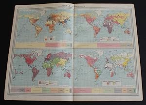
World Maps showing Population, Races, Religions and Principal Languages of Commerce from the 1920 Times Atlas (Plate 5) - single sheet containing 4 maps
Published by The Times, London, 1920
First Edition
Softcover. Condition: Very Good. Dust Jacket Condition: No Dust Jacket. First Edition. Disbound single sheet with vertical centre fold from the 1920 "The Times Survey Atlas of the World". Sheet is subdivided into four maps. Maps are in colour and sheet is suitable for framing. All maps have related bar charts underneath with contemporary statistical information. The four maps are coloured by: Population per square mile; Race of the World (with subdivisions of "White Type, Yellow Type and Black Type"); Religions across the World; Principal Languages of Commerce (bar chart shows data for European Languages only). Sheet has slightly darkened and worn edges with occasional light foxing. Sheet is otherwise clean and bright. Size: 46cm x 58cm approx. Quantity Available: 1. Shipped Weight: under 1 kg. Pictures of this item not already displayed here available upon request. Inventory No: 45020044034. All our books are sent by tracked mail.
-
Softcover. Condition: Very Good. Dust Jacket Condition: No Dust Jacket. First Edition. Disbound single sheet with horizontal centre fold from the 1920 "The Times Survey Atlas of the World". Map is in colour and is suitable for framing. Colour on both land and sea according to contour. Map at scale 1:633,600 with the Scilly Isles included in an inset continuation panel. Map covers Cornwall, Devon, Somerset, Dorset, Glamorgan, Monmouth, Merioneth, Montgomery, Hereford, Worcester, Birmingham, Bristol, Gloucester, Carmarthen, Pembroke, Cardigan, Brecknock, Stafford, Shropshire, Cardigan Bay, Bristol Channel, Lundy, Scilly Isles, Dartmoor, Exmoor, etc. etc. Slightly darkened and worn edges with occasional light foxing in the margins. Sheet is otherwise crisp and clean. Size: 58cm x 46cm approx. Quantity Available: 1. Shipped Weight: under 1 kg. Pictures of this item not already displayed here available upon request. Inventory No: 45020044024. All our books are sent by tracked mail.