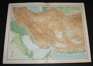
Map of "Persia" or modern day Iran from the 1920 Times Survey Atlas (Plate 53) including Bagdad, Basra, Bushire, Tabriz, Isfahan, Teheran, Fars, Khorasan, Kerman, Yezd and the Persian Gulf
The Times and J. G. Bartholomew
From
Bailgate Books Ltd, Doncaster, United Kingdom
Seller rating 5 out of 5 stars
![]()
AbeBooks Seller since 8 April 2003
About this Item
Description:
Disbound single sheet with vertical centre fold from the 1920 "The Times Survey Atlas of the World". Map is in colour and suitable for framing. Colour on both land and sea is by contour. Map at scale 1:4,000,000. Map covers modern day Iran with parts of Baluchistan, Afghanistan, Arabia, Mesopotamia and Qatar (Pakistan, Iraq) with Bagdad, Basra, Bushire, Tabriz, Isfahan, Teheran, Fars, Khorasan, Kerman, Yezd, the Persian Gulf, Strait of Ormuz, Caspian Sea (part), etc. Slightly darkened edges with occasional foxing in margins and near centre fold, sheet is otherwise clean and crisp. Item Type: Map. Single sheet map/chart which is suitable for framing and will be shipped rolled and in a cardboard tube. Quantity Available: 1. Shipped Weight: under 1 kg. Pictures of this item not already displayed here available upon request. Inventory No: 45020034055. All our books are sent by tracked mail. Seller Inventory # 45020034055
Bibliographic Details
Title: Map of "Persia" or modern day Iran from the ...
Publisher: The Times, London
Publication Date: 1920
Binding: Softcover
Condition: Very Good
Dust Jacket Condition: No Dust Jacket
Edition: First Edition.
AbeBooks offers millions of new, used, rare and out-of-print books, as well as cheap textbooks from thousands of booksellers around the world. Shopping on AbeBooks is easy, safe and 100% secure - search for your book, purchase a copy via our secure checkout and the bookseller ships it straight to you.
Search thousands of booksellers selling millions of new & used books
New & Used Books
New and used copies of new releases, best sellers and award winners. Save money with our huge selection.
Rare & Out of Print Books
From scarce first editions to sought-after signatures, find an array of rare, valuable and highly collectible books.


