
Order Total (1 Item Items):
Shipping Destination:

Stebbins Heman (1 results)
Skip to main search results
Search filters
Product Type
- All Product Types
- Books (No further results match this refinement)
- Magazines & Periodicals (No further results match this refinement)
- Comics (No further results match this refinement)
- Sheet Music (No further results match this refinement)
- Art, Prints & Posters (No further results match this refinement)
- Photographs (No further results match this refinement)
- Maps (1)
- Manuscripts & Paper Collectibles (No further results match this refinement)
Condition Learn more
- New (No further results match this refinement)
- As New, Fine or Near Fine (No further results match this refinement)
- Very Good or Good (No further results match this refinement)
- Fair or Poor (No further results match this refinement)
- As Described (1)
Binding
- All Bindings
- Hardcover (No further results match this refinement)
- Softcover (No further results match this refinement)
Collectible Attributes
- First Edition (No further results match this refinement)
- Signed (No further results match this refinement)
- Dust Jacket (No further results match this refinement)
- Seller-Supplied Images (1)
- Not Print on Demand (1)
Language (1)
Price
- Any Price
- Under � 20 (No further results match this refinement)
- � 20 to � 35 (No further results match this refinement)
- Over � 35
Free Shipping
- Free Shipping to U.S.A. (No further results match this refinement)
Seller Location
Seller Rating
-
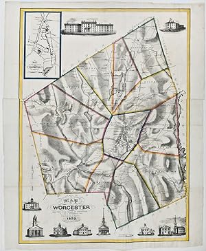
A Map of Worcester Shire Town of the County of Worcester
Published by Published by C. Harris, [Worcester], 1833
Seller: Donald A. Heald Rare Books (ABAA), New York, NY, U.S.A.
Seller rating 5 out of 5 stars

Map
Lithographed folding map, printed on two sheets joined, period hand-colouring in outline. Inset map of the "Village of Worcester." Ten vignette views of buildings, including churches, schools, the "Antiquarian Hall" (i.e. American Antiquarian Society), town hall, the "Lunatic Hospital" and "House of Corrections." The scarcest and most decorative map of Worcester published in the 19th century. "This 1833 map of the town of Worcester, Massachusetts, was printed by Pendleton's lithography. It is distinctive for its depiction of generalized relief and vegetation on the map and of churches and public buildings in the margins" (Ristow). The detail on the map is quite impressive, with hundreds of individual residences named and the locations of businesses identified. The hand coloured boundaries divide the county into twelve school districts. The printing of the map is exceptional, with the hachuring and views exquisitely rendered on stone by Pendleton's Lithography. Stebbins worked as a lawyer in South Brookfield, Massachusetts but was also a trained surveyor. Following work on this map, he was employed as a Civil Engineer by the Massachusetts Western Railroad. The map is rare, with no copies listed in the auction records. We can locate only the Harvard and University of Massachusetts copies. Ristow, American Maps and Mapmakers, p. 289. Not in Rumsey or Phillips, A List of Maps of America.