Order Total (1 Item Items):
Shipping Destination:

Sidney Hebert Editor Paris (1 results)
Skip to main search results
Search filters
Product Type
- All Product Types
- Books (No further results match this refinement)
- Magazines & Periodicals (No further results match this refinement)
- Comics (No further results match this refinement)
- Sheet Music (No further results match this refinement)
- Art, Prints & Posters (No further results match this refinement)
- Photographs (No further results match this refinement)
- Maps (1)
- Manuscripts & Paper Collectibles (No further results match this refinement)
Condition Learn more
- New (No further results match this refinement)
- As New, Fine or Near Fine (No further results match this refinement)
- Very Good or Good (1)
- Fair or Poor (No further results match this refinement)
- As Described (No further results match this refinement)
Binding
- All Bindings
- Hardcover (No further results match this refinement)
- Softcover (No further results match this refinement)
Collectible Attributes
- First Edition (No further results match this refinement)
- Signed (No further results match this refinement)
- Dust Jacket (No further results match this refinement)
- Seller-Supplied Images (1)
- Not Print on Demand (1)
Language (1)
Price
- Any Price
- Under � 20 (No further results match this refinement)
- � 20 to � 35 (No further results match this refinement)
- Over � 35
Free Shipping
- Free Shipping to U.S.A. (No further results match this refinement)
Seller Location
Seller Rating
-
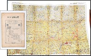
Bird's Eye Map c1915 France Region of Hazebrouck. Carte-Plan vol d'oiseau No 2 Lille. Tableau D'Assemblage de 22 cartes du Front
Published by France, 1915
Seller: Blind-Horse-Books (ABAA), DeLand, FL, U.S.A.
Association Member: ABAA ESA FABA ILAB IOBA
Seller rating 5 out of 5 stars

Map
Condition: Very Good. Map is in color, the paper has age toned. The cover title has a scuff. Two ownership stamps on blank side indicating this was the property of a 1st Lt Corps of Engers [Engineers] of an unidentified army. We presume it is British. Unfolded the map measures 30 by 23.5 inches. Folded 7.75 by 5.125 inches. The map is part of a set of 22. Date determined by other maps from this editor.