Order Total (1 Item Items):
Shipping Destination:

Roggeveen Arent (20 results)
Skip to main search results
Search filters
Product Type
- All Product Types
- Books (16)
- Magazines & Periodicals (No further results match this refinement)
- Comics (No further results match this refinement)
- Sheet Music (No further results match this refinement)
- Art, Prints & Posters (No further results match this refinement)
- Photographs (No further results match this refinement)
- Maps (4)
- Manuscripts & Paper Collectibles (No further results match this refinement)
Condition Learn more
- New (4)
- As New, Fine or Near Fine (2)
- Very Good or Good (5)
- Fair or Poor (No further results match this refinement)
- As Described (9)
Binding
- All Bindings
- Hardcover (15)
- Softcover (No further results match this refinement)
Collectible Attributes
- First Edition (No further results match this refinement)
- Signed (No further results match this refinement)
- Dust Jacket (5)
- Seller-Supplied Images (14)
- Not Print on Demand (16)
Language (2)
Free Shipping
Seller Location
Seller Rating
-
The Burning Fen Second Part Amsterdam 1687
Language: English
Published by Theatrum Orbis Terrarum Ltd., Amsterdam, 1971
ISBN 10: 9022110303 ISBN 13: 9789022110300
Hardcover. Condition: Near Fine. Dust Jacket Condition: Very Good. Arent Roggeveen and Jacob Robijn. The Burning Fen Second Part Amsterdam 1687. Amsterdam: Theatrum Orbis Terrarum Ltd., 1971, xii, 40 pp. + maps. *** This atlas is one in a series of facsimile atlases resurrected and produced by the Theatrum Orbis Terrarum project. The Burning Fen is the 4th. part of the new Great Sea-Mirrour, first published in 1687. It is a Pilot for the West African and Brazilian coasts. Historical background for this work is provided in an Introduction by Prof. Ir C. Koeman. The atlas contains large double-page maps done in the portolan style, with coastline views and sailing directions. With the original illustrated Dust Jacket. This book is in my inventory and the images are of this particular item. *** Bound in dark blue cloth boards and spine, clean with no wear, bottom corners lightly bumped. The jacket is clean with very light wear, one faint mark at bottom of front panel, a tiny closed tear (repaired on verso with archival tape) and a small wrinkle bottom right corner of front panel. The contents are clean and complete in a good binding. *** 18.25 inches tall by 12.25 inches.
-

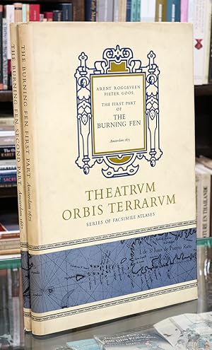
The Burning Fen First Part Amsterdam 1675
Published by Theatrvm Orbis, 1971
Seller: Midtown Scholar Bookstore, Harrisburg, PA, U.S.A.
Seller rating 5 out of 5 stars

Hardcover. Condition: Good. Torn/worn dj. Good hardcover with some shelfwear; may have previous owner's name inside. Jumbo-sized. Oversized.
-
The Burning Fen, Part I. & II.
Language: English
Published by Theatrum Orbis Terrarum, 1971
ISBN 10: 902211029X ISBN 13: 9789022110294
Seller: The Isseido Booksellers, ABAJ, ILAB, Tokyo, Japan
Association Member: ILAB
Seller rating 4 out of 5 stars

Hardcover. Condition: Good. Dust Jacket Condition: Fair. 3rd Edition. Amsterdam 1675 & 1687. With an Introduction by Dr Ir C. Koeman. Facsimile ed. Folio. 46.7 x 31cm. 2 vols. xv, 67, xii, 40pp. 52 folding map. Numerous text-illus. Original cloth, slightly worn. Dust jacket, slightly stained. (Theatrvm Orbis Terrarvm, Series of Facsimile Atlases, 5th Series, Vol. 5 & 6).
-

The Burning Fen First Part and Second Part
Language: English
Published by Theatrum Orbis Terrarum, Amsterdam Netherlands, 1971
ISBN 10: 902211029X ISBN 13: 9789022110294
Hardcover. Facsimile of 1675 & 1687 Editions. This very large valuable set will require extra shipping; please inquire. Pieter Goos' 1675 "Burning Fen the First Part", the Second Part in 1687 were the first pilot books containing charts of the Central America coasts and islands that appeared in print. These facsimiles are Vol. V (68 pages, ISBN 902211029X) and Vol. VI (40 pages, ISBN 9022110303) in the Fifth Series by this pubisher. ; Two Volume Set; 12 1/4 x 18 1/4 " Near Fine in Near Fine dust jacket.
-
The First Part of the Burning Fen - Amsterdam 1675 & The Second Part of the Burning Fen - Amsterdam 1687 (2 volumes)
Language: English
Published by Amsterdam : Theatrum Orbis Terrarum Limited, 1971
ISBN 10: 902211029X ISBN 13: 9789022110294
Condition: Good. 2 unirform original gilt lettered cloths, dust jackets, (double page) illustrations in b/w, folio. Theatrvm Orbis Terrarvm, Series of Facsimile Atlases, Fifth Series, Volume V and VI.
-
The First Part of the Burning Fen - Amsterdam 1675 & The Second Part of the Burning Fen - Amsterdam 1687 (2 volumes)
Language: English
Published by Amsterdam : Theatrum Orbis Terrarum Limited, 1971
ISBN 10: 902211029X ISBN 13: 9789022110294
Condition: Good. 2 uniform original gilt lettered cloths, dust jackets, (double page) illustrations in b/w, folio. Theatrvm Orbis Terrarvm, Series of Facsimile Atlases, Fifth Series, Volume V and VI.
-
The burning fen. Part 1 & 2.
Language: English
Published by Theatrum Orbis Terrarum, 1971
ISBN 10: 902211029X ISBN 13: 9789022110294
Seller: Kloof Booksellers & Scientia Verlag, Amsterdam, Netherlands
Seller rating 4 out of 5 stars
Condition: very good. With an introduction by C. Koeman. Amsterdam : Theatrum Orbis Terrarum, 1971. 2 Volumes. Reprint 1675-1687 edition. Orig. cloth binding. Dustjacket. 47 cm. (Theatrum orbis terrarum; series of atlases in facsimile ; 5th series, volumes 5-6). Originally published in Dutch under title: Het brandende veen. ISBN 902211029X 9022110303 Part 1 reprinted from the 1675 Amsterdam edition, published by Pieter Goos. Part 2 reprinted from the 1687 Amsterdam edition, issued by Jacob Robijn, as part 4 of The new great sea mirrour. The first printed West Indian Pilot, published as a sequel to the three parts of Goos" well known "Sea Mirrour" Additional shipping charges will be requested for international orders. Condition : very good copy. ISBN 9789022110294. Keywords : ,
-
The Burning Fen . The First Part [and] The Second Part.
Published by Amsterdam, Theatrum Orbis Terrarum 1970-1., 1970
Seller: Grant's Bookshop, Cheltenham, VIC, Australia
Association Member: ANZAAB ILAB
Seller rating 4 out of 5 stars
Two volumes. Folio. Vol. I. 68pp.( 34 double-page charts) . Vol.II. 40pp. ( 22 double-page charts ). Original cloth in dustwrappers. Black and white illustrations; a near fine set. . Facsimile reprint of the 1675 Amsterdam edition. Theatrum Orbis Terrarum: Series of Atlases. Fifth Series Vols V and VI. " The first printed West Indian Pilot, published as a sequel to the three parts of Goos' well known "Sea Mirrour". It was the prototype of the pilot guides for America produced by Johannes van Keulen (1683) and John Seller and John Thornton (1689)".
-
The Burning Fen (The first part -The Second part)
Published by Theatrum Orbis Terranum, 1971
Seller: Librairie de l'Avenue - Henri Veyrier, Saint-Ouen, FR, France
Seller rating 4 out of 5 stars
Couverture rigide. Condition: Bon �tat. 2 volumes. Grand in-4 toil�, sous jaquette illustr�e. Nombreuses illustrations. facsimile atlas in-folio.
-
The Burning Fen. Two volumes; First Part: Amsterdam 1675. Second Part: Amsterdam 1687. Introduction by Dr. Ir C. Koeman. (Series of Atlases in Facsimile, Fifth Series, Volume V)
Published by Theatrum Orbis Terrarum Ltd, Amsterdam, 1971
Seller: J. HOOD, BOOKSELLERS, ABAA/ILAB, Baldwin City, KS, U.S.A.
Seller rating 5 out of 5 stars
Hardcover. [lg folios] Vol. l: 34 double-page charts and 70pp of text; Vol. 2: 18 double-page charts and 40pp. Fine / slightly torn & soiled djs. Fine / slightly torn & soiled djs.
-
![Seller image for Het Staten lof en der zee-helden bazuyn ; uyt-geblasen [.] over de [.] victorye; bevochten op Den 11, 12, 13 en 14 Junij 1666. door de s'landts vlooten [.] onder [.] admirael Michiel de Ruyter [.] 1666 [LeatherBound] for sale by True World of Books](https://pictures.abebooks.com/inventory/md/md31885880812.jpg)
LeatherBound. Condition: New. BOOKS ARE EXEMPT FROM IMPORT DUTIES AND TARIFFS; NO EXTRA CHARGES APPLY. LeatherBound edition. Condition: New. Reprinted from 1666 edition. Leather Binding on Spine and Corners with Golden leaf printing on spine. Bound in genuine leather with Satin ribbon page markers and Spine with raised gilt bands. A perfect gift for your loved ones. Pages: 13 NO changes have been made to the original text. This is NOT a retyped or an ocr'd reprint. Illustrations, Index, if any, are included in black and white. Each page is checked manually before printing. As this print on demand book is reprinted from a very old book, there could be some missing or flawed pages, but we always try to make the book as complete as possible. Fold-outs, if any, are not part of the book. If the original book was published in multiple volumes then this reprint is of only one volume, not the whole set. Sewing binding for longer life, where the book block is actually sewn (smythe sewn/section sewn) with thread before binding which results in a more durable type of binding. Pages: 13.
-
![Seller image for Voorloper op 't Octroy, van de . Staten Generael, verleent aen Arent Roggeveen en sijn medestanders, over de Australisse Zee ofte beter geseght het onbekende gedeelte des Werelts, gelegen tusschen de meridiaen der Strate Magalanes Westwaert, tot de Meridiaen van Nova Gunea, soo noordtwaert als zuydtwaert Mitsg. de Articulen waer naer een yder die eenige somme gelts inteeckent hem sal hebben te reguleren; beneffens een Kaerte van't selfde district 1676 [LeatherBound] for sale by True World of Books](https://pictures.abebooks.com/inventory/md/md31617519690.jpg)
LeatherBound. Condition: New. BOOKS ARE EXEMPT FROM IMPORT DUTIES AND TARIFFS; NO EXTRA CHARGES APPLY. LeatherBound edition. Condition: New. Reprinted from 1676 edition. Leather Binding on Spine and Corners with Golden leaf printing on spine. Bound in genuine leather with Satin ribbon page markers and Spine with raised gilt bands. A perfect gift for your loved ones. Pages: 43 NO changes have been made to the original text. This is NOT a retyped or an ocr'd reprint. Illustrations, Index, if any, are included in black and white. Each page is checked manually before printing. As this print on demand book is reprinted from a very old book, there could be some missing or flawed pages, but we always try to make the book as complete as possible. Fold-outs, if any, are not part of the book. If the original book was published in multiple volumes then this reprint is of only one volume, not the whole set. Sewing binding for longer life, where the book block is actually sewn (smythe sewn/section sewn) with thread before binding which results in a more durable type of binding. Pages: 43.
-
![Seller image for Den Zeeuschen Merkurius, en Krans-drager, met gedachten uytgebeelt aen de Overlede Zee-Helden, gebleven voor 't Vaderlandt. In de Zee-slach . voor-gev. in de Noort-Zee, op den 4 Aug. 1666 . 1666 [LeatherBound] for sale by True World of Books](https://pictures.abebooks.com/inventory/md/md31617511164.jpg)
LeatherBound. Condition: New. BOOKS ARE EXEMPT FROM IMPORT DUTIES AND TARIFFS; NO EXTRA CHARGES APPLY. LeatherBound edition. Condition: New. Reprinted from 1666 edition. Leather Binding on Spine and Corners with Golden leaf printing on spine. Bound in genuine leather with Satin ribbon page markers and Spine with raised gilt bands. A perfect gift for your loved ones. Pages: 11 NO changes have been made to the original text. This is NOT a retyped or an ocr'd reprint. Illustrations, Index, if any, are included in black and white. Each page is checked manually before printing. As this print on demand book is reprinted from a very old book, there could be some missing or flawed pages, but we always try to make the book as complete as possible. Fold-outs, if any, are not part of the book. If the original book was published in multiple volumes then this reprint is of only one volume, not the whole set. Sewing binding for longer life, where the book block is actually sewn (smythe sewn/section sewn) with thread before binding which results in a more durable type of binding. Pages: 11.
-
![Seller image for Het nieuwe Droevige Nacht-Licht ontsteken door Godts toren, ende vertoont op den Aerdt-kloot in een Comeet ofte Staert-starre den 15 Dec. 1664, tot den 9 Febr. 1665, waer in wort aengewesen den wonderlieven loop der selve. Beschr. door Arent Roggeveen 1665 [LeatherBound] for sale by True World of Books](https://pictures.abebooks.com/inventory/md/md31617508468.jpg)
LeatherBound. Condition: New. BOOKS ARE EXEMPT FROM IMPORT DUTIES AND TARIFFS; NO EXTRA CHARGES APPLY. LeatherBound edition. Condition: New. Reprinted from 1665 edition. Leather Binding on Spine and Corners with Golden leaf printing on spine. Bound in genuine leather with Satin ribbon page markers and Spine with raised gilt bands. A perfect gift for your loved ones. Pages: 59 NO changes have been made to the original text. This is NOT a retyped or an ocr'd reprint. Illustrations, Index, if any, are included in black and white. Each page is checked manually before printing. As this print on demand book is reprinted from a very old book, there could be some missing or flawed pages, but we always try to make the book as complete as possible. Fold-outs, if any, are not part of the book. If the original book was published in multiple volumes then this reprint is of only one volume, not the whole set. Sewing binding for longer life, where the book block is actually sewn (smythe sewn/section sewn) with thread before binding which results in a more durable type of binding. Pages: 59.
-
The burning fen. With an introduction by C. Koeman.
Seller: Gert Jan Bestebreurtje Rare Books (ILAB), Vianen, Netherlands
Seller rating 5 out of 5 stars
Amsterdam, Theatrum Orbis Terrarum, 1971. 2 volumes. Large folio. Cloth, with dust-jackets. With many illustrations and 52 double-page charts. First edition published in Dutch: Het Brandende Veen. Part 1 reprinted from the 1675 Amsterdam edition, published by Pieter Goos. Part 2 reprinted from the 1687 Amsterdam edition, published by Jacob Robijn. Containing charts of the Central American coasts and islands, west coast of Africa and the coast of Brazil. The first printed West Indian Pilot, a prototype of the pilote guides for America. - A fine copy.
-
![Seller image for Caerte van de Cust van Florida tot de Verginis Streckende van Cabo de Canaveral tot Baya de la Madalena. [Carte from the Coast of Florida to Virginia Stretching from Cabo de Canaveral to Baya de la Madalena] for sale by Donald A. Heald Rare Books (ABAA)](https://pictures.abebooks.com/inventory/md/md31843546062.jpg)
Caerte van de Cust van Florida tot de Verginis Streckende van Cabo de Canaveral tot Baya de la Madalena. [Carte from the Coast of Florida to Virginia Stretching from Cabo de Canaveral to Baya de la Madalena]
Published by Amsterdam, 1675
Seller: Donald A. Heald Rare Books (ABAA), New York, NY, U.S.A.
Seller rating 5 out of 5 stars
Map
Engraving with contemporary hand-coloring on thick laid paper. The rare first sea chart from the Carolinas to Florida, here in a stunning hand-colored example. First state of Roggveen's rare sea chart of the Southeasten Coast of North America, the first sea chart to focus on the region and one of great importrance, showing the region through which the majority of Spain's treasure ships from the New World sailed. This map is based on Dutch East India Company sources, and draws heavily on Hessel Gerritsz's rare sea chart of 1631, which survives in only 3 known examples. The map also likely reflects a manuscript chart by Johannes Vingboons. But the place-names and most of the cartographic details derive from Spanish sources. The map appear in Roggeveen's so-called "Burning Fen," described by Koeman as "the most interesting of all maritime works produced by Pieter Goos." Roggeveen, born in Delshaven, came to Middleburg, the seat of both Dutch East and West India Companies, in 1658. He worked for both companies teaching the art of navigation and helped to maintain their collections of hydrographic manuscripts and charts, including Spanish portolans of the West Indies. In the mid-1660s, asssisted by his access to these collections, Roggeveen embarked upon compiling a series of large-scale charts of the North American coastline, West Indies, and later West Africa. Many of his charts are based on the earlier work of Hessel Gerritsz and Johannes Vingboons, both cartographers for the Dutch East and West India Companies, but Roggeveen's work as the first to show the whole coastline of North America and the Caribbean. He called this pilot "Het Brandende Veen" or "the Burning Fen," a pun on his name, as "veen" means "fen," and a heap of burning fen represents a fire on the coast to guide or warn ships. The atlases were intended for use at sea, so few complete examples survive. Working sea charts and pilots from the 17th century are inherently rare due to the nature of their use. The vast majority were either destroyed by use or destroyed intentionally when updated versions were obtained. Burden 452, first state. Cumming, Southeast 74 Koeman IV, Rog.1 (26) Lowery 162.
-
La Primera Parte Del Nuevo Gran Espejo Maritimo, Alumbrando las Costas Maritimas de la Navigacion de la India Occidental, Empecando de la Costa de Espana Hasta el Rio de Amazonas.
Published by Jacob Robijn,, Amsterdam,, 1690
Seller: Daniel Crouch Rare Books Ltd, London, United Kingdom
Association Member: ABA ILAB PBFA
Seller rating 4 out of 5 stars
Unrecorded Spanish edition of the First Sea Atlas of America Folio (450 by 280mm), title, privilege, [2]p. description of the earth, 67pp., 34 engraved charts (all double-page apart from the chart of Catalina), seventeenth century Spanish pig skin. One of the most important maritime atlases of the Dutch Golden Age. Roggeveen's work is the first maritime atlas of the American coasts, and was based largely on the closely guarded collection of mostly Iberian manuscript nautical charts owned by the Dutch East India Company (VOC) and West India Company (WIC). It covers what it calls the West Indies, a term then interpreted much more broadly than today, including not only the entire Caribbean, the Gulf of Mexico and Central America, but also part of South America and the entire east coast of what is now the United States and southern Canada. Arent Roggeveen (c.1628-1779) was born in Delfshaven, and came to Middelburg as a teacher in 1658. Familiar with mathematics and land-surveying and interested in astronomy, he quickly learned the arts of navigation. Middelburg boasted one of the most important chambers of both the VOC and WIC, therefore many of Roggeveen's students worked in the two companies. Through these connections he apparently gained access to the large collection of mostly Iberian manuscript sea charts that the companies had captured, copied by espionage, or commissioned (some American place names in Roggeveen's atlas still retain their Spanish forms). This collection had been closely guarded as a matter of national security during the Dutch war of independence from Spain. Even after 1648 it was still considered sensitive material, as it gave the Dutch merchants of the VOC and WIC an important commercial advantage. While some atlases largely copied maps from their predecessors, Roggeveen could therefore draw on this cartographic treasure trove to produce more accurate and more detailed sea charts than had ever been published before. The first edition of the atlas was published in 1675 by Pieter Goos, however, due to the death of Goos in the same year, and that of Roggeveen four years later, a second edition would not be published until 1680, by which time the plates had been acquired by the chart dealer Jacobus Robijn. Robijn went on to republish the second edition in 1689, with a third edition appearing in 1698. As well as Dutch the pilot also appeared with English, French, and - as with the present edition - Spanish text. We are unable to trace an institutional example of this edition. Koeman records six institutional examples of the 1680 Spanish edition. The charts and text would appear to be unchanged from the 1680 edition: with all the charts in their first state; the chart of Catalina is in its proof state; chart No. 7 bears revision to Cura�ao plate; whilst the chart of Cura�ao [No.7 1/2] bears no number. The only revision to the 1680 edition is the inclusion of a new title-page and privilege in which Roggeveen's name has been omitted and Jacob Robijn inserted in its place. c.f. Koeman Rog 10 for 1680 edition.
-

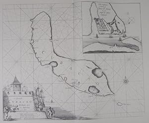
De Zeekusten van Westindien
Published by [c.1680], Amsterdam,, 1680
Seller: Daniel Crouch Rare Books Ltd, London, United Kingdom
Association Member: ABA ILAB PBFA
Seller rating 4 out of 5 stars
Map
This first large scale printed chart of Brazil and the Amazon Double-page engraved chart with fine hand-colour in part and in outline. Roggeveen's rare large scale chart of the Amazonian delta - published in Roggeveen's exceedingly rare sea pilot 'Het Brandende Veen'. This map shows the northern end of the Amazonian delta which empties out into the Atlantic to the lower leftmost corner, with the "Linea Aequinoetialis", or equator, clearly delineated. The coastal outline progresses into Brazil's northeastern coast in the Brazilian state of Amapa, whose River Oyapock (identified as "Rio Warypoco" in this map) marks the border between Brazil and French Guyana. Amapa was an historical administrative division of the former Portuguese colonial empires, who warded off English and Dutch invaders. Roggeveen, born in Delshaven, came to Middleburg, the seat of both the Dutch East and West India Companies, in 1658. He worked for both companies teaching the art of navigation and helped to maintain their collections of hydrographic manuscripts and charts, including Spanish portolans of the West Indies. In the mid-1660s, assisted by his access to these collections, Roggeveen embarked upon compiling a series of large-scale charts of the North American coastline, West Indies, and, later, West Africa. Many of his charts are based upon the earlier large-scale work of Hessel Gerritsz and Joan Vingboons, both cartographers for the Dutch East and West India Companies, but Roggeveen's work was the first to show the whole coastline of North America and the Caribbean. He called this pilot 'Het Brandende Veen' or 'The Burning Fen'; a pun on his name, as 'veen' means 'fen', and a heap of burning fen represents a fire on the coast to guide or warn ships. The first edition of the atlas was published in 1675 by Pieter Goos, however, due to the death of Goos in the same year, and that of Roggeveen four years later, a second edition would not be published until 1680, by which time the plates had been acquired by the chart dealer Jacobus Robijn. Robijn went on to republish the second edition in 1689, with a third edition appearing in 1698.
-
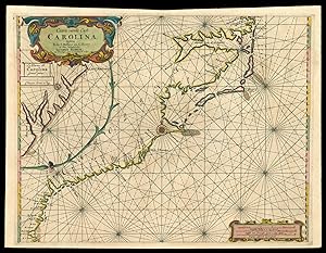
Caerte vande Cust Carolina Tusscheb B de S Matheo en C. Henry op Niew Verbeetert door
Published by Jacobus Robyn met Privilegio Voor is Iaaren A'o, Amsterdam,, 1687
Seller: Daniel Crouch Rare Books Ltd, London, United Kingdom
Association Member: ABA ILAB PBFA
Seller rating 4 out of 5 stars
Map
Carolina First state. Double-page engraved chart, with fine hand-colour in part and in outline. Large-scale sea chart of the Carolina coast - published in Roggeveen's exceedingly rare sea pilot 'Het Brandende Veen'. In 1687 Robijn replaced the earlier chart of the south-east with this one. It is interestingly derived from Johannes van Keulen's 'Pas Kaart Van de Kust van Carolina,' 1684, the publisher whom he had been working with in 1679. Robijn rotates the projection to a north-south one and in the process eliminates the south portion of Chesapeake Bay. The coastline is virtually identical but nomenclature does vary. One notable new addition is B de S. Anna and a sand bar is also placed at C Faire. The position of Charles Town is still on the south bank of the Rio Grande, a position from which it relocated in 1680. Roggeveen, born in Delshaven, came to Middleburg, the seat of both the Dutch East and West India Companies, in 1658. He worked for both companies teaching the art of navigation and helped to maintain their collections of hydrographic manuscripts and charts, including Spanish portolans of the West Indies. In the mid-1660s, assisted by his access to these collections, Roggeveen embarked upon compiling a series of large-scale charts of the North American coastline, West Indies, and, later, West Africa. Many of his charts are based upon the earlier large-scale work of Hessel Gerritsz and Joan Vingboons, both cartographers for the Dutch East and West India Companies, but Roggeveen's work was the first to show the whole coastline of North America and the Caribbean. He called this pilot 'Het Brandende Veen' or 'The Burning Fen'; a pun on his name, as 'veen' means 'fen', and a heap of burning fen represents a fire on the coast to guide or warn ships. The first edition of the atlas was published in 1675 by Pieter Goos, however, due to the death of Goos in the same year, and that of Roggeveen four years later, a second edition would not be published until 1680, by which time the plates had been acquired by the chart dealer Jacobus Robijn. Robijn went on to republish the second edition in 1689, with a third edition appearing in 1698. Burden 629 state 1.
-

De Cust van Westindien Punta St. Blaes
Published by [c.1680], Amsterdam,, 1680
Seller: Daniel Crouch Rare Books Ltd, London, United Kingdom
Association Member: ABA ILAB PBFA
Seller rating 4 out of 5 stars
Map
Panama Double-page engraved chart with fine hand-colour in part and in outline. First large-scale Dutch chart of the northern Panama coast and the San Blas Islands - published in Roggeveen's exceedingly rare sea pilot 'Het Brandende Veen'. Roggeveen, born in Delshaven, came to Middleburg, the seat of both the Dutch East and West India Companies, in 1658. He worked for both companies teaching the art of navigation and helped to maintain their collections of hydrographic manuscripts and charts, including Spanish portolans of the West Indies. In the mid-1660s, assisted by his access to these collections, Roggeveen embarked upon compiling a series of large-scale charts of the North American coastline, West Indies, and, later, West Africa. Many of his charts are based upon the earlier large-scale work of Hessel Gerritsz and Joan Vingboons, both cartographers for the Dutch East and West India Companies, but Roggeveen's work was the first to show the whole coastline of North America and the Caribbean. He called this pilot 'Het Brandende Veen' or 'The Burning Fen'; a pun on his name, as 'veen' means 'fen', and a heap of burning fen represents a fire on the coast to guide or warn ships. The first edition of the atlas was published in 1675 by Pieter Goos, however, due to the death of Goos in the same year, and that of Roggeveen four years later, a second edition would not be published until 1680, by which time the plates had been acquired by the chart dealer Jacobus Robijn. Robijn went on to republish the second edition in 1689, with a third edition appearing in 1698.