Richard Andrees (68 results)
 More images
Language: German
Published by Velhagen & Klasing, 1893
Seller: avelibro OHG, Dinkelscherben, Germanyavelibro OHG
Contact seller5-star sellerAssociation member: BOEV
Condition: Used - Good
£ 13.31
£ 8.62 shippingShips from Germany to U.S.A.Quantity: 1 available
4°, gebundene Ausgabe. Condition: Befriedigend. Deckel stark lagerspurig, Buchrücken mit fehlenden Teilstücken, Seiten altersgemäß angedunkelt, einzelne Seiten mit ein oder zwei geknickten Ecken, Seiten sonst sehr gut erhalten B05-01-01A Sprache: Deutsch Gewicht in Gramm: 951.
 More images
Andrees Berliner Schulatlas. Vollständige Ausgabe.
Andrees. - Malbranc, Karl / Hermann Kolbe und Richard Schmidt (Hg.):
Published by Bielefeld, Leipzig und Berlin; Velhagen & Klasing, 1939. 30. völlig neubearbeitete Auflage., 1939
- Hardcover
Seller: Antiquariat Carl Wegner, Berlin, B, GermanyAntiquariat Carl Wegner
Contact seller5-star sellerAssociation member: GIAQ
Condition: Used
£ 50.59
£ 7.75 shippingShips from Germany to U.S.A.Quantity: 1 available
Hardcover. 4°. Stark beriebener Pappband, der Rücken fehlend, die Blätter zumeist lose. Ein Besitzvermerk auf dem Vorsatz. Bei uns vorhanden: 1 Bl. Titel und Inhaltsverzeichnis; XX Karten Verwaltungsbezirke Berlins und Umgebungen; 12 S. Bilder und Karten aus der Mark Brandenburg, Märkische Landschaften, Boden und Besiedlung etc.…; 49 (+1) S. Die Landschaft in Karte und Bild, d.dt. Volksboden, Besiedlung, Volkstum etc.; 4 S. Statistischer Anhang; 1 Bl. Mit S-Bahn und U-Bahn Plan; 32 S. Deutschland und die weite Welt. Bilderanhang zu Velhagens Schulatlanten. In hiinterer Deckellasche 12 Geographische Tafeln auf 8 Seiten und 4 weitere wohl privat zusammengestellte Karten - wohl deutlich überkomplettes Exemplar. Die Blätter teils gedunkelt, in den Randbereichen begriffen und mit Schadstellen. Einige Falze leider mit Tesa hinterlegt. Arbeitsexemplar des seltenen Berliner Schulatlas. Die im Inhaltsverzeichnis angegeben Beilage fehlt ( wurde überhaupt ausgeliefert?). -- Bitte Portokosten außerhalb EU erfragen! / Please ask for postage costs outside EU! / S ' il vous plait demander des frais de port en dehors de l ' UE! // Bitte beachten Sie auch unsere Fotos! / Please also note our photos! / Veuillez noter nos photos -- Ob Sonnenschein oder warmer Regen: mit einem interessanten Buch kommen Sie immer gut durch den Tag. -- Wir kaufen Ihre werthaltigen Bücher! K04004.

Language: German
Published by Verlag von Velhagen & Klasing, Bielefeld und Leipzig, 1887
Seller: Paderbuch e.Kfm. Inh. Ralf R. Eichmann, Bad Lippspringe, NRW, GermanyPaderbuch e.Kfm. Inh. Ralf R. Eichmann
Contact seller5-star sellerCondition: Used - Fair
£ 10.65
£ 30.16 shippingShips from Germany to U.S.A.Quantity: 1 available
Unbound. Condition: acceptable. Richard Andrees (Hrsg.): Ägypten. Landkarte im Maßstab 1 : 5.000.000, Format 23 x 38 cm, grenzkoloriert, einmal gefaltet, sonst ordentlicher Zustand. Mit 2 Nebenkarten: Umgebung von Kairo - Umgebung von Chartum. Verlag von Velhagen & Klasing, Bielefeld und Leipzig 1887 (aus "Allgemeiner Handatlas"…).

Language: German
Published by Verlag von Velhagen & Klasing, Bielefeld und Leipzig, 1887
Seller: Paderbuch e.Kfm. Inh. Ralf R. Eichmann, Bad Lippspringe, NRW, GermanyPaderbuch e.Kfm. Inh. Ralf R. Eichmann
Contact seller5-star sellerCondition: Used - Fair
£ 10.65
£ 30.16 shippingShips from Germany to U.S.A.Quantity: 1 available
Unbound. Condition: acceptable. Richard Andrees (Hrsg.): Königreich Dänemark. Landkarte im Maßstab 1 : 1.500.000, Format 23 x 37 cm, grenzkoloriert, einmal gefaltet, sonst ordentlicher Zustand. Mit drei Nebenkarten: Bornholm - Island - Die Far-Öer. Verlag von Velhagen & Klasing, Bielefeld und Leipzig 1887 (aus "Allgemeiner Handa…tlas").

Language: German
Published by Verlag von Velhagen & Klasing, Bielefeld und Leipzig, 1887
Seller: Paderbuch e.Kfm. Inh. Ralf R. Eichmann, Bad Lippspringe, NRW, GermanyPaderbuch e.Kfm. Inh. Ralf R. Eichmann
Contact seller5-star sellerCondition: Used - Fair
£ 10.65
£ 30.16 shippingShips from Germany to U.S.A.Quantity: 1 available
Unbound. Condition: acceptable. Richard Andrees (Hrsg.): Afghanistan und Belutschistan. Landkarte im Maßstab 1 : 6.000.000, Format 24 x 36 cm, grenzkoloriert, einmal gefaltet, sonst ordentlicher Zustand. Verlag von Velhagen & Klasing, Bielefeld und Leipzig 1887 (aus "Allgemeiner Handatlas").

Language: German
Published by Verlag von Velhagen & Klasing, Bielefeld und Leipzig, 1887
Seller: Paderbuch e.Kfm. Inh. Ralf R. Eichmann, Bad Lippspringe, NRW, GermanyPaderbuch e.Kfm. Inh. Ralf R. Eichmann
Contact seller5-star sellerCondition: Used - Fair
£ 10.65
£ 30.16 shippingShips from Germany to U.S.A.Quantity: 1 available
Unbound. Condition: acceptable. Richard Andrees (Hrsg.): Provinz Sachsen, Mecklenburg und Anhalt. Landkarte im Maßstab 1 : 1.250.000, Format 23 x 36 cm, grenzkoloriert, einmal gefaltet, sonst ordentlicher Zustand. Verlag von Velhagen & Klasing, Bielefeld und Leipzig 1887 (aus "Allgemeiner Handatlas").

- Hardcover
Seller: Antiquariat Librissimo, Eicklingen, GermanyAntiquariat Librissimo
Contact seller5-star sellerCondition: Used
£ 10.65
£ 38.77 shippingShips from Germany to U.S.A.Quantity: 1 available
Sechste Auflage. Velhagen & Klasing, Bielefeld und Leipzig, 1914. 532 Seiten. Quart, Leinen (berieben/ kleine Stoßstelle am Vordergelenk)---.
- Hardcover
Seller: Celler Versandantiquariat, Eicklingen, GermanyCeller Versandantiquariat
Contact seller5-star sellerAssociation member: GIAQ
Condition: Used
£ 18.64
£ 32.74 shippingShips from Germany to U.S.A.Quantity: 1 available
39. Aufl., Velhagen & Klasing, Bielefeld, 1893. 34/8 S., Hln., quart, (Titelrand hinterlegt/stark bst.)--- 750 Gramm.

Published by Velhagen & Klasing, Bielefeld, Leipzig, 1890
- Hardcover
Seller: Antiquariat Puderbach, Dresden, GermanyAntiquariat Puderbach
Contact seller5-star sellerCondition: Used
£ 31.06
£ 41.36 shippingShips from Germany to U.S.A.Quantity: 1 available
Halbleder 43x29 cm, Einband stark berieben, Ecken und Rücken bestoßen, Rücken mit gr. Fehlstelle, Bindung gelockert, Buchblock gebrochen, Seiten fingerfleckig, Namenseintrag auf Titelseite, einige Seiten beschädigt oder mit kl. Markierungen. 117 S. Gewicht in Gramm: 3700 Zweite vermehrte und verbesserte Auflage, Zweiter revidier…ter Abdruck.

Language: German
Published by Verlag von Velhagen & Klasing, Bielefeld und Leipzig, 1887
Seller: Paderbuch e.Kfm. Inh. Ralf R. Eichmann, Bad Lippspringe, NRW, GermanyPaderbuch e.Kfm. Inh. Ralf R. Eichmann
Contact seller5-star sellerCondition: Used - Fair
£ 15.09
£ 30.16 shippingShips from Germany to U.S.A.Quantity: 1 available
Unbound. Condition: acceptable. Richard Andrees (Hrsg.): Hannover, Schleswig-Holstein und kleinere Norddeutsche Staaten. Landkarte im Maßstab 1 : 1.000.000, Format 37 x 46 cm, grenzkoloriert, zweimal gefaltet, sonst ordentlicher Zustand. Mit drei Nebenkarten: Umgebung von Hamburg - Fürstentum Birkenfeld - Umgebung von Kiel. Verl…ag von Velhagen & Klasing, Bielefeld und Leipzig 1887 (aus "Allgemeiner Handatlas").

Andrees Allgemeiner Handatlas in 99 Haupt- und 82 Nebenkarten, nebst vollständigem Namenverzeichnis. Dritte, völlig neubearbeitete und vermehrte Auflage. Zweiter revidierter und vermehrter Abdruck.
Andrees, Richard und Geographische Anstalt von Velhagen & Klasing in Leipzig (Hrsg.)
Published by Bielefeld und Leipzig; Verlag von Velhagen & Klasing, 1896
Seller: Antiquariat Hanfgarten, Heimiswil, CH, SwitzerlandAntiquariat Hanfgarten
Contact seller5-star sellerCondition: Used
£ 43.29
£ 12.49 shippingShips from Switzerland to U.S.A.Quantity: 1 available
Atlasband 140 Blatt, 188 Seiten; zusätzlich separates Namenverzeichnis zur 6. Auflage gedruckt 1924 mit 592 Seiten. Altlas Halbledereinband, Namenverzeichnis Kunstledereinband. Atlas Rücken oben und unten eingerissen, Einband stärkere Gebrauchsspuren, Ecken bestossen; innen gute Erhaltung. Zuschlag Paketpost 6'500 g (RO).
Published by Bielefeld und Leipzig; 1893, 1893
- Hardcover
Seller: Antiquariaat De Boekenbeurs, Middelburg, NetherlandsAntiquariaat De Boekenbeurs
Contact seller5-star sellerCondition: Used
£ 73.22
£ 13.36 shippingShips from Netherlands to U.S.A.Quantity: 1 available
; Verlag von Velhagen und Klasing; gilt printed portfolio; 29x43 cm.; with 64 folding maps. Portfolio a trifle worn and slight signs of use.
Published by Bielefeld und Leipzig; 1899, 1899
- Hardcover
Seller: Antiquariaat De Boekenbeurs, Middelburg, NetherlandsAntiquariaat De Boekenbeurs
Contact seller5-star sellerCondition: Used
£ 73.22
£ 13.36 shippingShips from Netherlands to U.S.A.Quantity: 1 available
; Verlag von Velhagen und Klasing; gilt printed portfolio; 29x43 cm.; with 53 folding maps; edited by A. Scobel. Portfolio a trifle worn.

Published by Velhagen & Klasing, 1898]., [Bielefeld and Leipzig,, 1898
- Map
Seller: Daniel Crouch Rare Books Ltd, London, United KingdomDaniel Crouch Rare Books Ltd
Contact seller4-star sellerCondition: Used
£ 40.00
£ 20.00 shippingShips from United Kingdom to U.S.A.Quantity: 1 available
From the fourth edition of 'Andrees Allgemeiner Handatlas Chromolithograph map. Published in the fourth edition of 'Andrees Allgemeiner Handatlas'. Velhagen & Klasing was a major German publishing company in the nineteenth and twentieth centuries. In the mid-to-late 1800s, Hirt & Sohn and Velhagen & Klasing together had an oligo…poly in the German textbook market.
Language: German
Published by Velhagen & Klasing, Bielefeld,, 1887
- Hardcover
Seller: Clerc Fremin, Steingaden, GermanyClerc Fremin
Contact seller5-star sellerCondition: Used
£ 57.69
£ 19.08 shippingShips from Germany to U.S.A.Quantity: 1 available
2. Auflage. 122+112 Seiten Vollständig. Zustand: keine Beschädigungen, Exemplar einer Privatbibliothek mit Kennungen. Ecken, Kanten gut. Der Rücken ist unten verletzt. Sprache: Deutsch Gewicht in Gramm: 2001 Hardcover mit Lederrücken, Leinen, Großformat.

Andrees Allgemeiner Handatlas in 99 Haupt- und 82 Nebenkarten, nebst vollständigem alphabetischem Namenverzeichnis. + Geographisches Handbuch zu Andrees Handatlas mit besonderer Berücksichtigung der politischen, wirtschaftlichen und statistischen Verhältnisse.
Andrees, Richard und Geographische Anstalt von Velhagen & Klasing in Leipzig (Hrsg.):
Language: German
Published by Bielefeld, Leipzig; Verlag von Velhagen & Klasing, 1896 + 1899., 1896
- Hardcover
Seller: BuchKultur Opitz, Konstanz, BW, GermanyBuchKultur Opitz
Contact seller5-star sellerCondition: Used
£ 75.43
£ 8.57 shippingShips from Germany to U.S.A.Quantity: 1 available
Gr.-Fol., OHLdr. 1 Doppelblatt Titel und Inhaltsverzeichnis, 140 Blatt und 188 S.; XII, 994 S. Rücken und Kanten des Atlas mit Nutzungsspuren, ansonsten sehr schön erhalten, Bindung und Seiten in sehr gutem Zustand. Geographisches Handbuch in HLdr. mit Lederecken und Marmorschnitt, Lagerspuren am Einband, schönes Exemplar. Sprac…he: Deutsch Gewicht in Gramm: 550 Dritte, völlig neubearbeitete und vermehrte Auflage. Zweiter revidierter und vermehrter Abdruck.

Published by BIELEFELD UND LEIPZIG, 1887
- Hardcover
Condition: Used - Near fine
£ 93.18
£ 36.19 shippingShips from France to U.S.A.Quantity: 1 available
Couverture rigide. Condition: bon. RO30118594: 1887. In-Folio. Cartonné. Etat d'usage, Coins frottés, Mors fendus, Intérieur acceptable. 122 planches de cartes en couleurs + 105 pages de texte. Texte en allemand. Quelques planches partiellement débrochées et deux planches débrochées. Un manque sur la planche 27/28. Une écriture…et quelques taches d'encres sur la page de titre. Mors du deuxième plat fendu sur 4/5 du mords. Coiffes en tête abimée. . . . Classification Dewey : 430-Langues germaniques. Allemand.
Published by Bielefeld u Leipzig Velhagen & Klasing /93, 1887
- Softcover
Seller: Neusser Buch & Kunst Antiquariat, Neuss, NRW, GermanyNeusser Buch & Kunst Antiquariat
Contact seller5-star sellerCondition: Used
£ 63.90
£ 64.62 shippingShips from Germany to U.S.A.Quantity: 1 available
1893. neue Kart. d. 2. Aufl. v. 1887 - d. 3. Aufl. v. 1893. 4° OLw.-Mappe. Mappe m. Einrissen u. etwas berieben, Karten leicht gebräunt u. fingerfleckig, sonst gut erhalten. Sprache: Deutschu 3,200 gr.
Published by Bielefeld u Leipzig Velhagen & Klasing, 1937
- Softcover
Seller: Neusser Buch & Kunst Antiquariat, Neuss, NRW, GermanyNeusser Buch & Kunst Antiquariat
Contact seller5-star sellerCondition: Used
£ 67.45
£ 64.62 shippingShips from Germany to U.S.A.Quantity: 1 available
0. ausgew., völlig neu bearb. Aufl. 2°. 16 S., 100 Kart., 122 S. Namenverz., OLw., vergold. Rück.-u. Deck.-Tit., leicht berieben, papierbedingt etwas gebräunt, sauber u. gut erhalten. Sprache: Deutschu 8,500 gr.
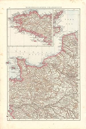
Seller: Art Source International Inc., Boulder, CO, U.S.A.Art Source International Inc.
Contact seller5-star sellerThis wonderful map was published by Dr. Richard Andrees in 1887, in Leipzig, Germany. German-made maps of this time period were known for their attention to detail and their fine engraving work. This map of Northwest France is the epitome of fine German printing. This map measures 9.5 inches by 14.5 inches.
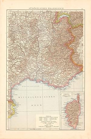
Seller: Art Source International Inc., Boulder, CO, U.S.A.Art Source International Inc.
Contact seller5-star sellerThis wonderful map was published by Dr. Richard Andrees in 1887, in Leipzig, Germany. German-made maps of this time period were known for their attention to detail and their fine engraving work. This map of Southeast France is the epitome of fine German printing. This map measures 9.5 inches by 14.5 inches.

Published by Von Velhagen & Klasing, Bielefeld und Leipzig, 1887
- Hardcover
Seller: Gene W. Baade, Books on the West, Renton, WA, U.S.A.Gene W. Baade, Books on the West
Contact seller5-star sellerAssociation member: IOBA
Hardcover. Condition: Fair. First Thus. 1st printing of the supplement, so far as we can tell. Folio in 1/2 leather & cloth. Only a fair copy. Hinges sound but covers spotted & worn & leather degraded. Maps good with marginal stains. The lower fore corner has a triangular stain on several leaves about 2 1/4" along the two edges…and arced out 2". Fair.
 More images
Language: German
Published by Velhagen und Klasing, Bielefeld und Leipzig, 1887
- Hardcover
Seller: Hartmut Diekmann, Berlin, GermanyHartmut Diekmann
Contact seller5-star sellerCondition: Used - Very good
£ 75.43
£ 16.11 shippingShips from Germany to U.S.A.Quantity: 1 available
Hardcover. Condition: Gut. 2. Auflage. grün-schwarzer OHld Bandmit goldgeprägtem Deckel- und Rückentitel. Ecken lederverstärkt. Ec ken und Rückenkanten berieben. Rücken unten eingerissen, oben circa 1cm Leder ausgerissen. Deckel mit geringen Gebrauchsspuren. Innen ausgezeichnet, traumhaft schön.
Published by Bielefeld und Leipzig, Verlag von Velhagen & Klasing, 1893, 1893
- Hardcover
Seller: Antiquariat & Kunsthandlung Bachmann & Rybicki - Dresden, Dresden, GermanyAntiquariat & Kunsthandlung Bachmann & Rybicki - Dresden
Contact seller4-star sellerCondition: Used
£ 141.99
£ 51.70 shippingShips from Germany to U.S.A.Quantity: 1 available
2°(42x29cm), 91 Hauptkarten, 86 Nebenkarten, Namensverzeichnis, 2nnS., 140 S.,1nnS., 166 S., Halbleder - Karten sind vollständig. Buchrücken mit Bünden, Schild goldgepr.(florale Verzierung), Buchdeckel goldgepr., Kanten berieben/bestoßen. Buchrücken vom Block gelöst. Teilw. braunfleckig, erste Seiten leicht wasserrandig, teilw.…hs. Vermerke, dritte Auflage.
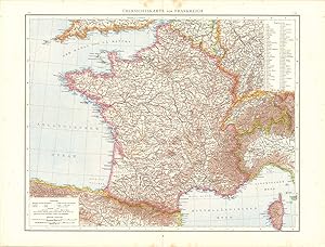
Seller: Art Source International Inc., Boulder, CO, U.S.A.Art Source International Inc.
Contact seller5-star sellerThis wonderful map was published by Dr. Richard Andrees in 1887, in Leipzig, Germany. German-made maps of this time period were known for their attention to detail and their fine engraving work. This map of France is the epitome of fine German printing. This map measures 18.5 inches by 14.5 inches.
Language: German
Published by Bielefeld u. Leipzig, Velhagen & Klasing, 1887
- Hardcover
Seller: Antiquariat Olaf Drescher, Nuthe-Urstromtal OT Nettgendorf, GermanyAntiquariat Olaf Drescher
Contact seller5-star sellerCondition: Used
£ 106.50
£ 12.02 shippingShips from Germany to U.S.A.Quantity: 1 available
1 Blatt Titel und Inhalt des Atlas, 120 farbige Kartenseiten, zwei Ergänzungskarten (Zentralafrika u. Deutsch-Ostafrika, 112 S. Alphabetisches (siebenspaltiges) Namenverzeichnis. Geographischer Handatlas in besonders gut erhaltenem alten Halbleder-Einband. - Zustand / Condition: Titel etwas gebräunt, mit 2 Besitzvermerken, sonst… sehr gut erhalten / Titel with light browning and two proprietors names, otherwise very fine. Sprache: Deutsch Gewicht in Gramm: 6400 43 x 29,5 cm, braunes Orig.-HALBLEDER mit Lederecken u. goldenem Deckeltitel und Emblem auf grünem Einband sowie goldenem Rückentitel und Jahreszahl am unteren Kapital.
 More images
Language: German
Published by Velhagen & Klasing, Leipzig, 1887
- Hardcover
Seller: Old Paper Old Ink, Murray, KY, U.S.A.Old Paper Old Ink
Contact seller4-star sellerCondition: Used - Very good
£ 116.53
£ 5.64 shippingShips within U.S.A.Quantity: 1 available
Hardcover. Condition: Very Good. No Jacket. Richard Andrees. Supplement zur Ersten Auflage von Richard Andrees Handatlas. Bielefeld un d Leipzig: Velhagen & Klasing, 1887, 34 pp. *** A collection of thirty-three (33) engraved lithograph maps with chromolitho. coloring. The European maps (14) are larger scale, regional maps. The…remaining maps cover parts of Asia, Africa, Oceana, and the Caribbean Islands. The maps are printed on both sides of a page. This atlas is in my inventory and the images are of this particular item. *** Bound in dark green cloth boards with a black leather spine and black leather corners. Marbled end papers. The covers have light wear and soil with moderate rubbing at corners and spine ends. Two short separations in joints have been repaired. The contents are complete in a good binding, mostly clean except for some light soil and/or foxing in margins of some maps. The maps have fresh, bright colors. *** 16.5 inches tall by 11.75 inches.

Seller: Art Source International Inc., Boulder, CO, U.S.A.Art Source International Inc.
Contact seller5-star sellerThis wonderful map was published by Dr. Richard Andrees in 1887, in Leipzig Germany. German-made maps of this time period were known for their attention to detail and their fine engraving work. This high layer map of Germany with population density is the epitome of fine German printing. This map measures 9 inches by 14.5 inches….

Seller: Art Source International Inc., Boulder, CO, U.S.A.Art Source International Inc.
Contact seller5-star sellerThis wonderful map was published by Dr. Richard Andrees in 1887, in Leipzig, Germany. German-made maps of this time period were known for their attention to detail and their fine engraving work. This map of Provinces of East and West Russia is the epitome of fine German printing. This map measures 14.5 inches by 9 inches.

Seller: Art Source International Inc., Boulder, CO, U.S.A.Art Source International Inc.
Contact seller5-star sellerThis wonderful map was published by Dr. Richard Andrees in 1887, in Leipzig Germany. German-made maps of this time period were known for their attention to detail and their fine engraving work. This map of the Big Ocean is the epitome of fine German printing. This map measures 14.5 inches by 9 inches.


