O W Gray Walling (41 results)

Published by The Bookmark, 1977
- Softcover
Seller: Berryville Old Book Shop, Berryville, VA, U.S.A.Berryville Old Book Shop
Contact seller5-star sellerOversized paperback. Reprint. 146 pgs. 1977 reproduction to scale of 1872 atlas. Very good softcover. Top edge of spine nicked. No international shipping due to size. (shop above Art).
Published by The Bookmark, Knightstown, IN, 1977
- Softcover
Seller: Riverow Bookshop, Owego, NY, U.S.A.Riverow Bookshop
Contact seller5-star sellerWraps. Condition: G/NO DUSTJACKET. Reprint. Knightstown, IN: The Bookmark. G/NO DUSTJACKET. 1977. Reprint. Wraps. Atlas Folio, 146 pp., cover rubbed & frayed . Black & White Illustrations (illustrator).
 More images
Language: English
Published by Stedman, Brown & Lyon, 1871
- Hardcover
- First Edition
Seller: Sequitur Books, Boonsboro, MD, U.S.A.Sequitur Books
Contact seller5-star sellerAssociation member: IOBA
Condition: Used - Very good
£ 422.96
£ 3.71 shippingShips within U.S.A.Quantity: 2 available
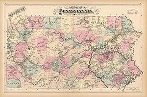
Hardcover. Condition: Very Good. First Edition. Large folio. (iii, 110, 19, 7, 4, 7 pages) : color maps. 25 (of 26) maps. Modern 3/4 cloth, original boards. Good binding. Occasional spotting. 6 double-page and 28 single-page maps of Pennsylvania, covering every county in the state as well as city plans of Philadelphia, Reading,…Lancaster and Allentown. Several thematic maps depict the geology, climatology, flora, and mineral deposits throughout the state. The atlas also includes Gray's double-page Map of the United States and Territories. In addition to the maps, there is extensive text on botany, climatology, education, geology, topography, zoology, and the history of the state. The atlas also provides population data from the US censuses of 1860 and 1870 for each county, township and borough in Pennsylvania, as well as an extensive classified section of businesses in each county and the cities of Philadelphia and Pittsburgh. Le Gear L-2995, Phillips 2453. This is an oversized or heavy book, that requires additional postage for international delivery outside the US.
Seller: Art Source International Inc., Boulder, CO, U.S.A.Art Source International Inc.
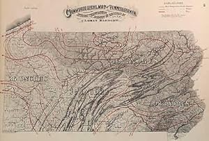
Contact seller5-star sellerThis antique climatological map is from the Topographical Atlas of the State of Pennsylvania created by Henry F. Walling and O.W. Gray, in 1872. Highlighted in red outline color are the means of temperature for the summer, winter, and the year. Shading within the map indicates the amount of rain fall during the year. This map me…asures 17 inches by 11.5 inches.

Published by H. F. Waling & O. W. Gray, Boston, 1871
- Map
Seller: mediumraremaps.com, Franklin, TN, U.S.A.mediumraremaps.com
Contact seller4-star sellerCondition: Used - Very good
£ 53.83
£ 4.48 shippingShips within U.S.A.Quantity: 1 available
25 1/2 x 16 1/2 inches. Condition: Very good condition. This is a fine example of lithographic image complemented by hand coloring at the time of publication. With the completion of the cross continental railroad combination of the Union Pacific Railroad and the Central Pacific Railroad in 1869, the railroad network of the U.S.…was ready for spohistication west of the Mississippi River. The network east of the Mississippi River was rebuilding after the Civil War. This map focuses on the railroads in place in 1871. Railroads were most dense on the East Coast. As one traveled west the availability of connections diminished. The Kansas Pacific was notable in it connection of the mid-continent to the Union Pacific. Chicago was the principal city for railroads and it is shown on the map as well connected. The railroads are not labeled but are quite traceable such as the Illinois Central and Louisville and Nashville. The New York Central is better laid out than its competitor the Grand /trunk railroad. Southern Florida is void of railroads. This is a very nice presentation of 1871 United States railroads.
Published by Philadelphia, 1872
Seller: Between the Covers-Rare Books, Inc. ABAA, Gloucester City, NJ, U.S.A.Between the Covers-Rare Books, Inc. ABAA
Contact seller5-star sellerCondition: Used - Near fine
£ 57.68
£ 4.11 shippingShips within U.S.A.Quantity: 1 available
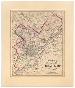
Unbound. Condition: Near Fine. A 14.75" x 12" map matted to a larger frame unexamined outside of the mat. Slight age-toning else near fine in shrink wrap. A map removed from the *Topographical Atlas of the State of Pennsylvania* by Henry F. Walling and O.W. Gray considered the "first real atlas of the state." Walling was associa…ted with Layfette College at the time and was the primary editor of the book while Gray, a Philadelphia civil engineer, provided the maps.
Seller: Art Source International Inc., Boulder, CO, U.S.A.Art Source International Inc.
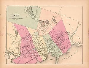
Contact seller5-star sellerThis hand colored map is from Walling and Grays Official Topographical Atlas of Massachusetts from Astronomical, Trigonometrical, and Various Local Surveys published in 1871. This bright pastel map of the City of Lynn and its surrounding areas illustrates the street plan of the area. Details include rail lines, the names of neig…hborhoods, rail lines, lakes and rivers as well as important buildings. This map measures 14.5 inches by 11 inches.

Seller: Art Source International Inc., Boulder, CO, U.S.A.Art Source International Inc.
Contact seller5-star sellerThis antique map is from the Topographical Atlas of the State of Pennsylvania created by Henry F. Walling and O.W. Gray, in 1872. The maps brilliance is obvious through the hand coloring of pink, green, tan, and yellow. Railroad lines and town names are identified throughout the entire map. This map measures 15.5 inches by 11.5…inches.

Seller: Art Source International Inc., Boulder, CO, U.S.A.Art Source International Inc.
Contact seller5-star sellerThis antique map is from the Topographical Atlas of the State of Pennsylvania created by Henry F. Walling and O.W. Gray, in 1872. The maps brilliance is obvious through the hand coloring of pink, green, and yellow. In addition to the counties of Erie, Crawford, and Venango, Lake Erie and the State of New York are briefly illustr…ated as well. This map measures 11.5 inches by 16.5 inches.
Published by Stedman, Brown and Lyon, Philadelphia, PA, 1872
- Hardcover
- First Edition
Seller: Saucony Book Shop, Kutztown, PA, U.S.A.Saucony Book Shop
Contact seller5-star sellerCondition: Used - Very good
£ 461.41
£ 4.48 shippingShips within U.S.A.Quantity: 1 available
Hardcover. Condition: Very Good. 1st Edition. Burgundy-brown 1/2 leather, brown cloth, lettered in gilt, decorated in blind, marbled endpapers and text block edges. Cover cloth mildly faded/tanned toward edges, with a small section of dampstaing along front cover fore-edge, leather rubbed along joints and showing minor exposure…at corners. Back cover cloth is dampstained along most of fore-edge and bottom edge. Firm binding, with dampstaining showing up only slightly along bottom edges of a few latter leaves. 39 pp. text + 82 maps (12 city, 66 county, 6 general maps including double-page map of U.S.). Size: Elephant Folio - over 15" - 23" tall. Book.
Seller: Art Source International Inc., Boulder, CO, U.S.A.Art Source International Inc.
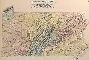
Contact seller5-star sellerThis antique map is from the Topographical Atlas of the State of Pennsylvania created by Henry F. Walling and O.W. Gray, in 1872. The maps brilliance is obvious through the hand coloring of pink, blue, and yellow. These colors illustrate the distribution of the state's flora. It was created by Tho C. Porter who was a professor o…f Botany at Lafayette College in Easton, Pennsylvania. This map measures 16.5 inches by 11.5 inches.
Seller: Art Source International Inc., Boulder, CO, U.S.A.Art Source International Inc.
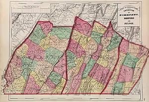
Contact seller5-star sellerAre you from Pennsylvania, or know someone who is? This antique map is from the Topographical Atlas of the State of Pennsylvania created by Henry F. Walling and O.W. Gray, in 1872. The maps uniqueness is obvious by the hand coloring of pink, green, tan, and yellow. Railroad lines and town names of Somerset, Bedford, and Fulton c…ounties are clearly identified. The detailed information and brilliant coloring make this map a perfect gift. This map measures 17.5 inches by 11.5 inches.
Seller: Art Source International Inc., Boulder, CO, U.S.A.Art Source International Inc.
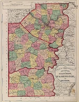
Contact seller5-star sellerThis antique map is from the Topographical Atlas of the State of Pennsylvania created by Henry F. Walling and O.W. Gray, in 1872. The maps brilliance is obvious through the hand coloring of pink, green, yellow, and tan. In addition to the counties of Allegheny, Washington, and Greene, surrounding counties and towns can be seen a…s well. This map measures 11.5 inches by 15.5 inches.

Seller: Art Source International Inc., Boulder, CO, U.S.A.Art Source International Inc.
Contact seller5-star sellerThis antique map is from the Topographical Atlas of the State of Pennsylvania created by Henry F. Walling and O.W. Gray, in 1872. The maps brilliance is obvious through the hand coloring of pink, green, yellow, and tan. In addition to the counties of Jefferson, Clarion, Indiana, and Armstrong, surrounding counties and towns can…be seen as well. This map measures 11.5 inches by 15.5 inches.

Seller: Art Source International Inc., Boulder, CO, U.S.A.Art Source International Inc.
Contact seller5-star sellerThis antique map is from the Topographical Atlas of the State of Pennsylvania created by Henry F. Walling and O.W. Gray, in 1872. The maps brilliance is obvious through the hand coloring of pink, green, yellow, and tan. In addition to the counties of Warren, McKean, Potter, Forest, Elk, and Cameron, surrounding counties and town…s can be seen as well. This map measures 24 inches by 15.5 inches.
Seller: Art Source International Inc., Boulder, CO, U.S.A.Art Source International Inc.
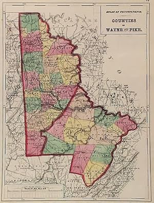
Contact seller5-star sellerThis antique map is from the Topographical Atlas of the State of Pennsylvania created by Henry F. Walling and O.W. Gray, in 1872. The maps brilliance is obvious through the hand coloring of pink, green, tan, and yellow. Railroad lines, street and town names are identified throughout the entire map. In addition to the counties of… Wayne and Pike, surrounding counties and towns can be seen as well. This map measures 11.5 inches by 15.5 inches.
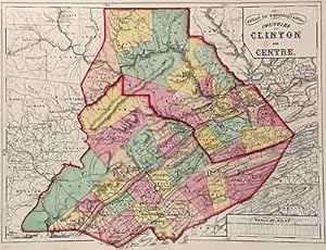
Seller: Art Source International Inc., Boulder, CO, U.S.A.Art Source International Inc.
Contact seller5-star sellerAre you from Pennsylvania, or know someone who is" This antique map is from the Topographical Atlas of the State of Pennsylvania created by Henry F. Walling and O.W. Gray, in 1872. The maps uniqueness is obvious by the hand coloring of pink, green, tan, and yellow. Railroad lines and town names of Clinton and Centre counties are… identified throughout the entire map. The detailed information and brilliant coloring make this map a perfect gift. This map measures 15.5 inches by 11.5 inches.
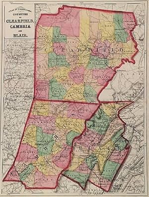
Seller: Art Source International Inc., Boulder, CO, U.S.A.Art Source International Inc.
Contact seller5-star sellerThis antique map is from the Topographical Atlas of the State of Pennsylvania created by Henry F. Walling and O.W. Gray, in 1872. The maps brilliance is obvious through the hand coloring of pink, green, yellow, and tan. In addition to the counties of Clearfield, Cambria, and Blair, surrounding counties and towns can be seen as w…ell.names. This map measures 11.5 inches by 15.5 inches.
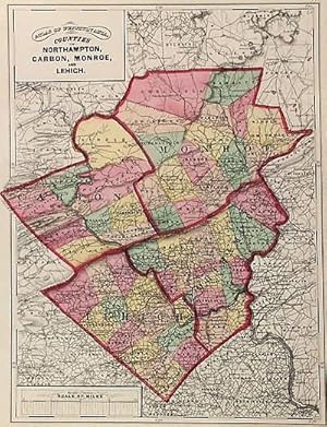
Seller: Art Source International Inc., Boulder, CO, U.S.A.Art Source International Inc.
Contact seller5-star sellerThis antique map is from the Topographical Atlas of the State of Pennsylvania created by Henry F. Walling and O.W. Gray, in 1872. The maps brilliance is obvious through the hand coloring of pink, green, tan, and yellow. Railroad lines, street and town names are identified throughout the entire map. In addition to the counties of… Northampton, Carbon, Monroe, and Lehigh, surrounding counties and towns can be seen as well. This map measures 11.5 inches by 16.5 inches.
Seller: Art Source International Inc., Boulder, CO, U.S.A.Art Source International Inc.
Contact seller5-star sellerThis antique map is from the Topographical Atlas of the State of Pennsylvania created by Henry F. Walling and O.W. Gray, in 1872. The maps brilliance is obvious through the hand coloring of red, blue, green, and yellow. These colors illustrate the principal deposits of iron, anthracite coal, petroleum, and zinc. This map measure…s 16.5 inches by 11 inches.
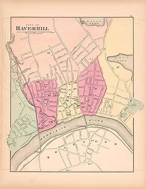
Seller: Art Source International Inc., Boulder, CO, U.S.A.Art Source International Inc.
Contact seller5-star sellerThis hand colored map is from Walling and Grays Official Topographical Atlas of Massachusetts from Astronomical, Trigonometrical, and Various Local Surveys published in 1871. This bright pastel map of Haverhill and its surrounding areas illustrates the street plan of the area. Details include rail lines, the names of neighborhoo…ds, rail lines,lakes and rivers as well as important buildings. This map measures 11 inches by 14 inches.
Seller: Art Source International Inc., Boulder, CO, U.S.A.Art Source International Inc.
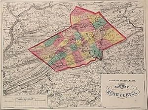
Contact seller5-star sellerThis antique map is from the Topographical Atlas of the State of Pennsylvania created by Henry F. Walling and O.W. Gray, in 1872. The maps brilliance is obvious through the hand coloring of pink, green, tan, and yellow. Railroad lines and town names are identified throughout the entire map. In addition to the county of Schuylkil…l, surrounding counties and towns can be seen as well. This map measures 15.5 inches by 11.5 inches.
Seller: Art Source International Inc., Boulder, CO, U.S.A.Art Source International Inc.
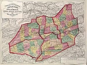
Contact seller5-star sellerThis antique map is from the Topographical Atlas of the State of Pennsylvania created by Henry F. Walling and O.W. Gray, in 1872. The maps brilliance is obvious through the hand coloring of pink, green, tan, and yellow. Railroad lines and town names are identified throughout the entire map. In addition to the counties of Columbi…a, Union, Snyder, Montour, and Northumberland, surrounding counties and towns can be seen as well. This map measures 15.5 inches by 11.5 inches.
Seller: Art Source International Inc., Boulder, CO, U.S.A.Art Source International Inc.
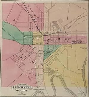
Contact seller5-star sellerThis antique map is from the Topographical Atlas of the State of Pennsylvania created by Henry F. Walling and O.W. Gray, in 1872. The maps brilliance is obvious through the hand coloring of pink, green, yellow, and tan. This map features the city of Lancaster detailing prisons, schools, parks, churches, cemeteries, railroads, an…d street names. This map measures 12 inches by 13 inches.
Seller: Art Source International Inc., Boulder, CO, U.S.A.Art Source International Inc.
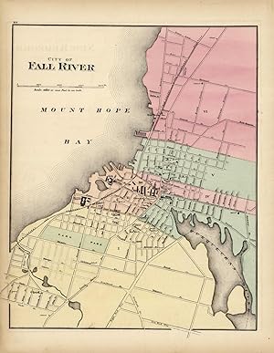
Contact seller5-star sellerThis hand colored map is from Walling and Grays Official Topographical Atlas of Massachusetts from Astronomical, Trigonometrical, and Various Local Surveys published in 1871. This bright pastel map of Fall River and its surrounding areas illustrates the street plan of the area. Details include rail lines, the names of neighborho…ods, rail lines, lakes and rivers as well as important buildings. This map measures 11.5 inches by 14 inches.
Seller: Art Source International Inc., Boulder, CO, U.S.A.Art Source International Inc.
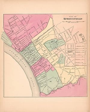
Contact seller5-star sellerThis hand colored map is from Walling and Grays Official Topographical Atlas of Massachusetts from Astronomical, Trigonometrical, and Various Local Surveys published in 1871. This bright pastel map of the City of Springfield and its surrounding areas illustrates the street plan of the area. Details include rail lines, the names…of neighborhoods,rail lines,lakes and rivers as well as important buildings. This map measures 11.75 inches by 12 inches.
Seller: Art Source International Inc., Boulder, CO, U.S.A.Art Source International Inc.
Contact seller5-star sellerThis antique map is from the Topographical Atlas of the State of Pennsylvania created by Henry F. Walling and O.W. Gray, in 1872. The maps brilliance is obvious through the hand coloring of pink, yellow, red, and tan. These colors illustrate the various geological formations including upper and lower coal series; coal measures;…Devonian; upper and lower Silurian; New Red; and Cambrian, Huronian, Lawrentian, Azoic, or Primary. This map measures 16.5 inches by 11 inches.
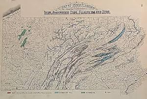
Seller: Art Source International Inc., Boulder, CO, U.S.A.Art Source International Inc.
Contact seller5-star sellerFantastic Railway map of Pennsylvania by Henry Walling & O.W. Gray, date 1872.This very detailed maps shows every railroad line in operation in 1872, it also shows every stop along the routes. This is unusual for most maps just show the line themselves.This map also details other towns, and rivers, as well as counties.Over all a… great map of Pennsylvania, and very hard to find. This map measures 24 inches by 15.5 inches.
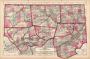
Seller: Art Source International Inc., Boulder, CO, U.S.A.Art Source International Inc.
Contact seller5-star sellerThis antique map is from the Topographical Atlas of the State of Pennsylvania created by Henry F. Walling and O.W. Gray, in 1872. The maps brilliance is obvious through the hand coloring of pink, green, tan, and yellow. Railroad lines, street and town names are identified throughout the entire map. In addition to the counties of… Tioga, Luzerne, Bradford, Sullivan, Wyoming, Susquehanna, and Lycoming, surrounding counties and towns can be seen as well. This map measures 24 inches by 16.5 inches.

Seller: Art Source International Inc., Boulder, CO, U.S.A.Art Source International Inc.
Contact seller5-star sellerAre you from Pennsylvania, or know someone who is? This antique map is from the Topographical Atlas of the State of Pennsylvania created by Henry F. Walling and O.W. Gray, in 1872. The maps uniqueness is obvious by the hand coloring of pink, green, tan, and yellow. The city of Reading is detailed with railroad lines and stations…, street names, parks, and cemeteries. Along the edge of the city runs the Schuylkill River. The thorough information and brilliant coloring make this map a perfect gift. This map measures 11 inches by 13.5 inches.


