Order Total (1 Item Items):
Shipping Destination:

Maps New Jersey (2 results)
Skip to main search results
Search filters
Product Type
- All Product Types
- Books (1)
- Magazines & Periodicals (No further results match this refinement)
- Comics (No further results match this refinement)
- Sheet Music (No further results match this refinement)
- Art, Prints & Posters (No further results match this refinement)
- Photographs (No further results match this refinement)
- Maps (1)
- Manuscripts & Paper Collectibles (No further results match this refinement)
Condition Learn more
- New (No further results match this refinement)
- As New, Fine or Near Fine (No further results match this refinement)
- Very Good or Good (1)
- Fair or Poor (No further results match this refinement)
- As Described (1)
Binding
- All Bindings
- Hardcover (1)
- Softcover (No further results match this refinement)
Collectible Attributes
- First Edition (1)
- Signed (No further results match this refinement)
- Dust Jacket (No further results match this refinement)
- Seller-Supplied Images (1)
- Not Print on Demand (2)
Language (1)
Price
- Any Price
- Under � 20 (No further results match this refinement)
- � 20 to � 35 (No further results match this refinement)
- Over � 35
Free Shipping
Seller Location
Seller Rating
-

A survey of the Empire Group, with a complete distance table, a compendious index of cities and post offices, with populations and much statistical data. . . .
Published by The Bullard Co., Inc.,, Boston:, 1909
Seller: Zephyr Used & Rare Books, Vancouver, WA, U.S.A.
Association Member: ABAA CBA ESA ILAB
Seller rating 5 out of 5 stars

Large folding accordion-style folded map printed in red & black, sized 41 x 38 in., which when entirely folded into covers measures 5.5 x 11.25 in. Original burgundy-coloured boards, small lozenge map of New York & Pennsylvania on front cover (some edgewear, rubbing, minor tidemark to upper fore-edge of 1 corner), still VG- copy. Second edition, revised, of this scarce and well documented map showing good roads for automobile travel, railroads, canals, new Erie Barge Canal, Steamship lines, ferries, lighthouses, electric railway lines, and more. First published in 1908, and then again in 1910, MacNair drew from US government surveys, State surveys, and other original commercial sources. Worldcat locates 2 copies.
-
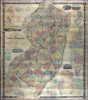
Topographical Map of the State of New Jersey Together with the Vicinities of New York and Philadelphia, and with Most of the State of Delaware from the State Geological Survey and the U.S. Coast Survey, and from Surveys by G. Morgan Hopkins, Civil Engineer
Published by William Kitchell, Philadelphia, 1860
Map First Edition
No binding. Condition: Very good. First. Philadelphia: William Kitchell, 1860. Four joined sheets (67 1/2" x 58"). Scale: 2 1/2 miles to the inch. Hand-colored engraving. Competently restored with no major losses, backed on modern canvas. Kitchell's was the largest map of New Jersey published in the nineteenth century. It was an attempt to show all the roads in the state. Red lines border the twenty-one counties. Townships are tinted in pink, yellow, blue, orange, or light green. Inset around the sides are seventeen city or town maps -- Belvidere, Beverly, Bordentown, Burlington, Camden, Elizabeth, Jersey City/Hoboken, Morristown, Mount Holly, New Brunswick, Newark, Newton, Orange, Paterson, Rahway, Salem, Trenton -- and views of Camden, Delaware Water Gap, New Brunswick, Newark, Paterson, and Trenton. The presence of the branch of the Raritan and Delaware Bay Railroad through Monmouth County to Long Branch, which had just opened in June 1860, confirms the map's timeliness. Also included on this huge cartographic tapestry are a state meteorological map by Lorin Blodget, broadly defining annual rainfall and average mean temperature regions, and a time dial, "showing the time at the several County Seats when it is 12 o'clock at the Capitol." (Though American and Canadian railroads began using time zones in 1883, standard time zones were not established by Congress until 1918; before that, most places relied on "solar time," or time determined by the sun's movement.) Blodget (1823-1901) was an important figure in American climatology; his New Jersey climate map drew from his popular treatise Climatology of the United States (1857). The box at the left center of the map compares the "capacities of churches" by denomination: Methodists and Presbyterians account for more than half of the religious residents in New Jersey at this time. A geological survey of New Jersey ran 1836-1840 under the direction of Henry D. Rogers, New Jersey's first state geologist. Unfunded for fourteen years, it was resurrected by William Kitchell (1827-1861), when he was appointed state geologist and superintendent of the newly formed New Jersey Geological Survey in 1854. Funding was again stopped after two years, until the New Jersey Agricultural Society pressured the legislature in 1860, lobbying for the Survey's potential agricultural and other benefits. "An act relative to the geological survey of this state" was approved on March 15, 1860. The law allowed Kitchell the use of already-completed field maps, woodcuts, and survey apparatus -- which he was obligated to return to the state after the completion of his work -- but the resulting maps and reports from the new survey had to be published at his own cost. In addition, the law directed Kitchell to provide the state with ten copies of his new state map for the state library and state offices, to give one copy to the state agricultural society, and to deposit one in each county clerk's office for the benefit of the people. Under the direction of Kitchell, civil engineer Griffith Morgan Hopkins, Jr., compiled the latest work of the New Jersey Geological Survey and the U.S. Coast Survey. The result was this magnificent map, published privately in Philadelphia later that same year. Catalogued by Cole Edwards.