Map Starling Thomas (4 results)

Language: English
Published by Mr Bull, United Kingdom, 1832
- Map
Seller: Pendleburys - the bookshop in the hills, Llanwrda, United KingdomPendleburys - the bookshop in the hills
Contact seller5-star sellerCondition: Used - Very good
£ 16.95
£ 11.50 shippingShips from United Kingdom to U.S.A.Quantity: 1 available
No Binding. Condition: Very Good. No Jacket. miniature map of West Africa taken from the 'Geographical Annual or Cabinet Atlas', copper engraved and coloured by hand, sheet measures 6 1/2" x 4 1/4". Adjoining leaf gives the principal places with longitude and latitude.

Language: English
Published by Mr Bull, United Kingdom, 1832
- Map
Seller: Pendleburys - the bookshop in the hills, Llanwrda, United KingdomPendleburys - the bookshop in the hills
Contact seller5-star sellerCondition: Used - Very good
£ 16.95
£ 11.50 shippingShips from United Kingdom to U.S.A.Quantity: 1 available
No Binding. Condition: Very Good. No Jacket. miniature map of the Italian States taken from the 'Geographical Annual or Cabinet Atlas', copper engraved and coloured by hand, sheet measures 6 1/2" x 4 1/4". Adjoining leaf gives the principal places with longitude and latitude.
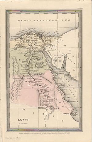
Published by Published for the Proprietors by Mr. Bull. (1833)., London., 1833
Seller: Asia Bookroom ANZAAB/ILAB, Canberra, ACT, AustraliaAsia Bookroom ANZAAB/ILAB
Contact seller5-star sellerCondition: Used
£ 40.22
£ 15.86 shippingShips from Australia to U.S.A.Quantity: 1 available
Engraved map, 14.1 x 8.8 cm, original hand colour in very good condition. Fine miniature map with appealing hand colour denoting Lower, Central and Upper Egypt.

Published by London. Published for the Proprietors Mr. Bull, Holles St., 1830, 1830
Seller: J. Patrick McGahern Books Inc. (ABAC), Ottawa, ON, CanadaJ. Patrick McGahern Books Inc. (ABAC)
Contact seller4-star sellerCondition: Used - Fine
£ 54.71
£ 7.46 shippingShips from Canada to U.S.A.Quantity: 1 available
No Binding. Condition: Fine. 16x 10cm (6.25"x 4"), (image, 9x 14cm), attractively hand coloured, fine - Bonar Law #311. p224. - One of 40 maps from the "Geographical Annual" designed and engraved by London engraver, Thomas Starling. A nice example of miniature cartography.


