
Order Total (1 Item Items):
Shipping Destination:

Lindgren Jolly (4 results)
Skip to main search results
Search filters
Product Type
- All Product Types
- Books (No further results match this refinement)
- Magazines & Periodicals (No further results match this refinement)
- Comics (No further results match this refinement)
- Sheet Music (No further results match this refinement)
- Art, Prints & Posters (No further results match this refinement)
- Photographs (No further results match this refinement)
- Maps (4)
- Manuscripts & Paper Collectibles (No further results match this refinement)
Condition Learn more
- New (No further results match this refinement)
- As New, Fine or Near Fine (No further results match this refinement)
- Very Good or Good (No further results match this refinement)
- Fair or Poor (No further results match this refinement)
- As Described (4)
Binding
- All Bindings
- Hardcover (No further results match this refinement)
- Softcover (No further results match this refinement)
Collectible Attributes
- First Edition (No further results match this refinement)
- Signed (No further results match this refinement)
- Dust Jacket (No further results match this refinement)
- Seller-Supplied Images (4)
- Not Print on Demand (4)
Language (1)
Price
- Any Price
- Under � 20 (No further results match this refinement)
- � 20 to � 35 (No further results match this refinement)
- Over � 35
Free Shipping
- Free Shipping to U.S.A. (No further results match this refinement)
Seller Location
Seller Rating
-

A Hysterical Map of Idaho - It's Got Everything and Plenty of it
Published by Lindgren-Turner Co, Spokane, WA, 1945
Seller: Tschanz Rare Books, Salt Lake City, UT, U.S.A.
Association Member: ABAA ILAB RMABA
Seller rating 5 out of 5 stars

Map
Illustrated king size mapcard [22 cm x 14 cm] printed in color. Card is bright and in nice condition. Divided back. Charming illustrated map of the Gem State. Attractions and sites are located, including lakes, rivers, geologic features, towns, etc. "Made on purpose by Jolly Lindgren" The Lindgren brothers of Spokane, Washington, were commercial sign makers through the 1920s, as the economic depression of the 1930s took hold in the once prosperous Pacific Northwest, Jolly Lindgren began drawing maps of western National Parks (Yosemite, Yellowstone, Zion, Bryce, Grand Canyon, Rocky Mountain and others) sites and towns (Death Valley, Grand Coulee, Lake Tahoe, Jackson Hole, Black Hills, Puget Sound, Palm Springs) and western states (Washington, Oregon, Montana, California, Utah and likely others). These whimsical maps were named 'Hysterical Maps' and included many jokes and puns. These maps proved to be quite successful and were produced through the 1940s.
-
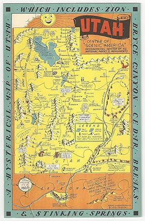
A Hysterical Map of Utah - Which Includes Zion, Bryce Canyon, Cedar Breaks and Stinking Springs
Published by Lindgren-Turner Co, Spokane, WA, 1940
Seller: Tschanz Rare Books, Salt Lake City, UT, U.S.A.
Association Member: ABAA ILAB RMABA
Seller rating 5 out of 5 stars
Map
Illustrated map jigsaw puzzle [23 cm x 15 cm] printed in color. Puzzle is bright and in nice condition. Envelope shows minor sunning and extremities. Charming illustrated map of Utah that locates town, parks, mountains, lakes, etc. This is not something that we have encountered previously. "Drawn in Broken English by Jolly Lindgren". Not in OCLC. Not in Rumsey. The Lindgren brothers of Spokane, Washington, were commercial sign makers through the 1920s, as the economic depression of the 1930s took hold in the once prosperous Pacific Northwest, Jolly Lindgren began drawing maps of western National Parks (Yosemite, Yellowstone, Zion, Bryce, Grand Canyon, Rocky Mountain and others) sites and towns (Death Valley, Grand Coulee, Lake Tahoe, Jackson Hole, Black Hills, Puget Sound, Palm Springs) and western states (Washington, Oregon, Montana, California, Utah and likely others). These whimsical maps were named 'Hysterical Maps' and included many jokes and puns. These maps proved to be quite successful and were produced through the 1940s.
-

A Hysterical Map of Grand Canyon National Park. A Mile Deep and Ever So Wide. Where Mother Nature Started from Scratch.
Publication Date: 1940
Seller: Geographicus Rare Antique Maps, Brooklyn, NY, U.S.A.
Association Member: ABAA ESA ILAB
Seller rating 4 out of 5 stars

Map
Very good. Wear along original fold lines. Blank on verso. Size 16 x 21.5 Inches. This is a humorous 1940 Jolly Lindgren pictorial map of Grand Canyon National Park, one of the less common works from the Hysterical Map series. A Closer Look The map depicts the Grand Canyon National Park from the Kanab Plateau and Mount Sinyala to the Painted Desert and from the Kaibab National Forest to the Tusayan National Forest. Comments and asides in Lindgren's inimitable style are scattered throughout. Lindgren's signature birds soar over the canyon, deriding his work ('A nightmare in Technicolor! and 'It ain't neat but it's pretty!') and commenting on the canyon ('Looks like the Colorado is in a rut!'). A 'No Dumping' sign is prominently displayed along the North Rim, hinting at humanity's unfortunate inclination to fill creek beds, ditches, etc., with garbage. Numerous locations throughout the canyon are labeled, including several temples (such as Isis Temple), points, gorges, buttes, and rapids along the Colorado River. Steamboat Mountain, one of the more recognizable locations within the Grand Canyon, is illustrated here as an actual steamboat. A legend in the bottom left corner explains the notations used, and asks the question, 'Don't you think the canyon is a trifle over-done?' Grand Canyon Carved by the Colorado River over the course of millions of years, the Grand Canyon has fascinated visitors for centuries and is considered to be a holy site by the Pueblo people. Originally established as a game preserve by President Theodore Roosevelt, T.R. changed its status to a U.S. National Monument in 1908, following passage of the Antiquities Act in 1906. It would take another 11 years before Grand Canyon National Park would be established in 1919 during the presidency of Woodrow Wilson. Lindgren Brothers Hysterical Maps Starting in 1932, the Lindgren Brothers of Spokane, Washington, began issuing medium-format pictorial maps, mostly of national parks, which they dubbed 'Hysterical.' The maps were doubtless influenced by the comparable work of American mapmakers Jo Mora and Harrison Godwin, as well as international figures like MacDonald Gill. Lindgren maps were simply illustrated with primary colors and lighthearted content, meant to get a laugh or at least a raised eyebrow. They emerged in the Interwar Period (1918 - 1939), an era defined by the breakdown of social structure, widespread disillusionment, the Great Depression, industrialization, and breakneck technological advances. In the United States, spurred by the ease of movement brought about by the automobile, infrastructure investment by New Deal programs, escapism into nature, and affordability, a nationwide love affair with our National Parks emerged - and remains. The Lindgrens capitalized on this unique situation to introduce an affordable, mailable souvenir - the Hysterical Map. Both visually striking and funny, the Hysterical Map could be framed and displayed as a happy memento or folded and mailed to friends and family. The Lindgrens made maps of most of the Great National Parks, as well as other points of interest, though they kept a broad focus on the Western United States. Hysterical Maps remained in production until about 1954. Publication History and Census This map was created and published by Jolly Lindgren and published by Lindgren Brothers in 1940. There are only a handful of examples of this map in institutional collections. We invite readers to read our evolving cartobibliography of Lindgren Brothers maps here: References: Rumsey 11092.002. OCLC 456453641. Geographicus #23_1940.
-

A Hysterical Map of the Jackson Hole Country and Grand Teton National Park. Slightly Cockeyed.
Publication Date: 1948
Seller: Geographicus Rare Antique Maps, Brooklyn, NY, U.S.A.
Association Member: ABAA ESA ILAB
Seller rating 4 out of 5 stars
Map
Very good. Slight wear on old fold lines. Size 22 x 17 Inches. A blend of the comic and the practical, this is a 1948 Jolly Lindgren larger format pictorial map of Jackson Hole and Grand Teton, Wyoming. This is one of the rarer of Lindgren's 'Hysterical' map series, which gained popularity against the grim backdrop of first the Great Depression and World War II. A Closer Look The map is loosely centered on the Cathedral Group, with Jackson Lake just north of center. 'Hysterical' vignettes and captions throughout provide humorous commentary on Grand Teton, Jackson Hole, and the vicinity. On the more serious side, Lindgren marks hotels, campsites, ranger stations, shops, mountains, trails, and other key locations. There are several references to hamburgers, including 'Hamburgers (on the hoof) and 'Jackson Hamburgers'. Grand Teton National Park Grand Teton National Park was established in 1929 in northwestern Wyoming. It is renowned for its stunning mountain landscapes and diverse wildlife. The park dates back to efforts by conservationists like John D. Rockefeller Jr., who played a crucial role in expanding the park. Initially, only the Teton Range and some surrounding lakes were protected, but in the 1940s, Rockefeller quietly purchased over 35,000 acres of land in the Jackson Hole Valley and donated it to the federal government. This led to the park's expansion in 1950, two years before this map was made, creating the Grand Teton National Park as it is known today. The park preserves not only the dramatic Teton Range but also the cultural history of Native Americans, early pioneers, and fur trappers who once inhabited the region. Lindgren's 'Hysterical' Maps Between roughly 1930 and 1950, Hjalmer 'Jolly' Lindgren (1895 - September 1952) and his brother Oscar 'Ott' Lindgren (1893 - 1967) issued a series of 'Hysterical Maps' detailing American national parks and monuments. Jolly was the artist while his brother, Oscar, ran the business. Jolly imagined the maps as comic relief, as well as a reminder of the world's most beautiful places during both the Great Depression and the subsequent World War II (1939 - 1945) Era. He wrote, 'What this country needs now is something to put a smile on people's faces.' The maps are graphically interesting and intended, as the titles suggest, to amuse. The brothers focused on producing maps of popular tourist attractions, and the great national parks of the West were an obvious choice. They produced maps of Yellowstone, the Grand Canyon, Glacier, Zion, Bryce Canyon, and others through the early 1940s. Some were also issued as postcards. Today, Lindgren's larger maps are highly desirable, and many are extremely rare. There is no complete census of Lindgren's full corpus. Publication History and Census This map was created by Jolly Lindgren and first published by Lindgren Brothers in 1948. Lindgren made multiple maps of Jackson Hole, and while some of the humor persists throughout the series, each is unique, reflecting the regional developments between 1935 and 1950. The first map appeared in 1935, with a red-bordered variation following in 1936. In 1947, a new map was issued, extending coverage. In 1948, this map, another new production, was issued. References: Rumsey 9945.000. OCLC 43328780.