Order Total (1 Item Items):
Shipping Destination:

Keller Imfeld (6 results)
Skip to main search results
Search filters
Product Type
- All Product Types
- Books (5)
- Magazines & Periodicals (No further results match this refinement)
- Comics (No further results match this refinement)
- Sheet Music (No further results match this refinement)
- Art, Prints & Posters (No further results match this refinement)
- Photographs (No further results match this refinement)
- Maps (1)
- Manuscripts & Paper Collectibles (No further results match this refinement)
Condition Learn more
- New (No further results match this refinement)
- As New, Fine or Near Fine (No further results match this refinement)
- Very Good or Good (No further results match this refinement)
- Fair or Poor (No further results match this refinement)
- As Described (6)
Binding
- All Bindings
- Hardcover (2)
- Softcover (No further results match this refinement)
Collectible Attributes
- First Edition (No further results match this refinement)
- Signed (No further results match this refinement)
- Dust Jacket (No further results match this refinement)
- Seller-Supplied Images (2)
- Not Print on Demand (6)
Language (2)
Free Shipping
- Free Shipping to U.S.A. (No further results match this refinement)
Seller Location
Seller Rating
-

Karte von Zürich-& Adlisberg bis Forch 1: 125000. Verschönerungs-Verein von Zürich und Umgebung. Bearbeitet für seine Mitglieder. Vorderseite: Aussicht vom Pfannenstil, nach der Natur gezeichnet von H.Keller und X.Imfeld / Gebirgsansicht vom Loorenkopf, . aufgenommen und in Stein gezeichnet von Albert Bosshard. Rückseite: Karte.
Language: German
Published by Zürich, Kartographische Anstalt Hofer & Co.AG,, 1917
Seller: Antiquariat Gerber AG, ILAB/VEBUKU/VSAR, Basel, Switzerland
Association Member: ILAB VEBUKU
Seller rating 3 out of 5 stars

4.Auflage. 1 mehrfach gefaltetes Blatt (Blattgrösse: 38 cm. x 97 cm.). 4 farbig lithogr.Panoramen und 1 farbig lithogr.Karte. Aussen leicht fleckig und an den Deckelrändern stellenweise berieben; Papier gebräunt. Sprache: Deutsch Gewicht in Gramm: 70 19 cm.x 9,5 cm. Original-Karte mit farbig illustr.Kartondeckeln.
-
Aussicht vom Pfannenstiel ("Okenshöhe" ob Meilen am Zürich-See). Nach der Natur gezeichnet. Gedruckt auf Kosten der Mittwoch-Gesellschaft in Meilen.
Published by Zurich, (J. J. Hofer, lith., for) Hch. Keller, 1879
Seller: Hellmut Schumann Antiquariat, Zurich, Switzerland
Association Member: ILAB VEBUKU
Seller rating 5 out of 5 stars

Folding panorama in color lithography, c. 16,5 x 127 cm. Orig. half cloth with lith.illus. on front cover and map on lower cover. Zurich, (J. J. Hofer, lith., for) Hch. Keller, 1879. Paronama in color, with the names of the mountain peaks in upper margin, the place names in lower margin. Shows the Greifensee and the Lake of Zurich with Uster, Egg, Rapperswil, Meilen, Oberrieden, etc. - Cut-out from a prospectus pasted into lower cover, some foxing. - Graf, Landesvermessung (1892), p. 480. GEOGRAPHY: MAPS ; ZH ; KARTEN, KARTOGRAPHIE ;
-
Aussicht vom fürstlich Fürstenberg?schen Schlosse Heiligenberg.
Seller: Antiquariat Fatzer ILAB, Zug, Switzerland
Association Member: ILAB VEBUKU
Seller rating 5 out of 5 stars
Friedrichshafen, Gessler 1999 (Faksimile des Panorama von 1881). 8°. 17,5 x 410 cm. Farbiges Panorama, gefaltet und Beiheft 38 S. In Original Leinen.-Mappe mit aufgezogener Titelillustration. (Alpenpanorama am Bodensee).
-
Karte von Zürich & Adlisberg bis Forch. 1:12?500. 4. Auflage.
Seller: Antiquariat Fatzer ILAB, Zug, Switzerland
Association Member: ILAB VEBUKU
Seller rating 5 out of 5 stars
Zürich, Verschönerungs-Verein 1917. 37 x 55 cm. Farbige Karte, gefaltet. Verso Panorama von Keller, H. und X. Imfeld. Aussicht vom Pfannenstiel (Okenshöhe, ob Meilen a. Zürich-See) & Albert Bosshard. Gebirgs-Ansicht vom Loorenkopf. Mit ill. Orig.Falttitelblatt. Gutes Exemplar.
-

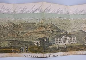
Panorama von Rigi-Kulm. 1800 Met. üb. Meer (Abtheilung I: das Hochgebirge).
Published by H. Keller Géogr. Verlag in Zürich, Druck v. J.J. Hofer (1879),, 1879
Seller: Harteveld Rare Books Ltd., Marly, Switzerland
Association Member: ILAB VEBUKU
Seller rating 4 out of 5 stars

106x19.5 cm, gefalt. koloriertes Panorama, ohne Umschlag. Please notify before visiting to see a book. Prices are excl. VAT/TVA (only Switzerland) & postage.
-
Natur-Treuestes Panorama vom Rigi-Kulm. Vollständige Rundsicht. Abtheilung I: Das Hochgebirge. Abtheilung II: Hügelland und Jura.
Language: German
Published by Zürich: Heinrich Keller [um 1879]., 1879
Map
Landkarte. 2 colorierte und lithographierte Panoramakarten vom Rigi-Kulmauf einem Blatt (recto u. verso), von Xaver Imfeld und J. J. Hofer nach Heinrich Keller. Blattgröße ca. 20 x 110 cm, gef. ca. 20 x 130 cm. Orig.-Halbleinenmappe mit aufmontiertem Titel. Deckel stark bestoßen, Kanten mit Fehlstellen. Karte etw. stockfleckig, Fußsteg knapp beschnitten, etw. Textverlust. Mit Stempel und Signatur einer aufgelösten Klosterbibliothek. atx 27.4.9.9/11 Sprache: Deutsch Gewicht in Gramm: 200.