Order Total (1 Item Items):
Shipping Destination:

Janssonius Jan (215 results)
Skip to main search results
Search filters
Product Type
- All Product Types
- Books (123)
- Magazines & Periodicals (No further results match this refinement)
- Comics (No further results match this refinement)
- Sheet Music (No further results match this refinement)
- Art, Prints & Posters (7)
- Photographs (No further results match this refinement)
- Maps (85)
- Manuscripts & Paper Collectibles (No further results match this refinement)
Condition Learn more
Binding
Collectible Attributes
- First Edition (1)
- Signed (1)
- Dust Jacket (No further results match this refinement)
- Seller-Supplied Images (181)
- Not Print on Demand (194)
Language (4)
Free Shipping
Seller Location
Seller Rating
-

Botanical Pen-portraits.
Published by The Hague : Nijhoff , 1923, 1923
Seller: Wissenschaftliches Antiquariat K�ln Dr. Sebastian Peters UG, K�ln, Germany
Seller rating 5 out of 5 stars

Condition: gut. 472 S., Abb., 28 cm, Einband leicht fleckig, gebr�unt. Sprache: Englisch.
-

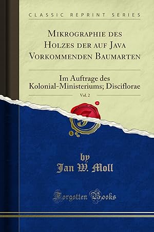
Im Auftrage Des Kolonial-Ministeriums
Language: English
Published by LIGHTNING SOURCE INC, 2016
ISBN 10: 1357456085 ISBN 13: 9781357456085
Gebunden. Condition: New. KlappentextThis work has been selected by scholars as being culturally important, and is part of the knowledge base of civilization as we know it. This work was reproduced from the original artifact, and remains as true to the original w.
-
Paperback. Condition: New. Print on Demand. This book meticulously details the anatomy of the wood of 18 plant species, three varietals, and one form, belonging to 12 genera found across Indonesia. The author presents a comprehensive analysis of the physical characteristics of each species, such as the thickness, width, and porosity of the wood, and the patterns of its pores and fibers. The author also discusses the growth zones visible in the wood and the distribution of parenchyma cells. The author concludes the book by presenting a table that readers may use to identify the various species based on the unique characteristics of their wood. This in-depth study of Indonesian plant wood anatomy enhances our understanding of the diversity and utility of these plant species and is a valuable resource for botanists and wood scientists. This book is a reproduction of an important historical work, digitally reconstructed using state-of-the-art technology to preserve the original format. In rare cases, an imperfection in the original, such as a blemish or missing page, may be replicated in the book. print-on-demand item.
-
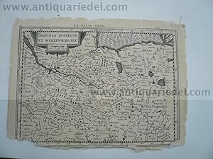
Saxonia Inferior et Meklenborg duc. Kupferstich von P. Kaerius
Published by Janssonius Jan,1588-1664, 1664
Hardcover. Condition: very good. Saxonia Inferior et Meklenborg duc. Kupferstich von P. Kaerius bei J. Janssonius, Amsterdam, 1630, 14 x 20 cm. Aus G. Mercator, "Atlas Minor", franz�sische Ausgabe. - Karte mit den Herzogt�mern L�neburg und Lauenburg, Mecklenburg, Pommern und der Mark Brandenburg. Im Norden die Ostsee von Travem�nde bis Wolgast, im S�den Celle und Spandau, im Westen Walsrode, im Osten Templin. DIVERSE RANDL�SUREN,geringer Bildverlust, einige Wurml�chlein.
-
Paperback. Condition: New. Print on Demand. This book investigates the anatomy of 26 genera and 49 species of legumes found in Java using a variety of techniques including chemical testing, species observation, and microscopy. There were 118 total samples examined. The species examined here are part of a larger study begun in the 1850s that sought to identify the structure and characteristics of legumes across the globe. To that end, the author provides a history of the research into the anatomy of legumes and an overview of the species previously studied. The author details the techniques used in the study, including the creation of cross-sections of samples to observe cellular structure and chemical reactions to specific stains and dyes. They identify the various tissues found in legumes, including vessels, fibers, and parenchyma cells which can vary significantly between species. This in-depth study provides critical information for the identification and classification of legumes, which can assist in fields such as botany, forestry, and agriculture. This book is a reproduction of an important historical work, digitally reconstructed using state-of-the-art technology to preserve the original format. In rare cases, an imperfection in the original, such as a blemish or missing page, may be replicated in the book. print-on-demand item.
-
Hardcover. Condition: very good. Salzburg/K�rnten, anno 1640, Karte, Janssonius J., alt auf Tr�gerkarton aufgezogen, 35x47 cm., besch�digt mit Bildverlust.
-
Hardcover. Condition: very good. Donaulauf anno 1640, Janssonius J., bis Belgrad, Kupferkarte, 45x50 cm., auf Tr�gerkarton aufgezogen, am Fu� gr�ssere Fehlstellen/Bildverlust.
-
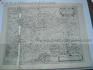
Westphalia Ducatus, anno 1640, Karte Janssonius, Janssonius, J.
Published by Janssonius Jan,1588-1664, 1664
Hardcover. Condition: very good. Westphalia Ducatus, anno 1640, Karte Janssonius, Janssonius, J. Westphalia Ducatus. Amstelodami, Excudebat Ioannes Ianssonius. 38 x 50 cm. Auf Karton aufgezogen. Sch�ne Kupferstich Landkarte von Westphalen von J. Janssonius. Mit zwei sch�nen Kartuschen. Zeigt die Gegend zwischen Essen, Olpe, Landau und Lippe mit Meschede im Zentrum. Links stark besch�digt mit Bildverlust.
-
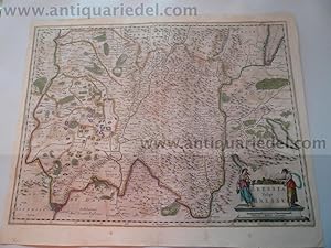
Territory Basiliensis Nova Descriptio - Ioannes Ianssonius Excud
Published by Janssonius Jan,1588-1664, 1664
Hardcover. Condition: very good. Territory Basiliensis Nova Descriptio - Ioannes Ianssonius Excudit. - Petrus Kaerius Caelavit':. Kupferstich v. Peter Kaerius b. Johannes Janssonius (Jansson) in Amsterdam, 1647, 38 x 49 . Gedruckt auf dickem Papier, breitrandig, diverse hinterlegte Wurml�suren mit geringem Bildverlust an der Mittelfalz. Bitte sehen Sie sich die Bilder an.- Zeigt den Kanton Basel (Basel-Landschaft) zwischen dem Rheinlauf von Waldshut bis Breisach mit dem Schwarzwald und dem Oberelsass. - Im Zentrum Basel. - Unten links Titelkartusche mit Wappen u. Meilenzeiger;
-
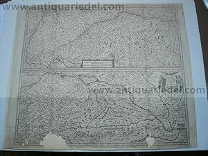
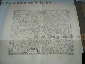
Braunschweig-Norddeutschland, anno 1650, Janssonius: BRAVNSWYCK
Published by Janssonius Jan,1588-1664, 1664
Hardcover. Condition: very good. Braunschweig-Norddeutschland, anno 1650, Janssonius: BRAVNSWYCK & MEYDBVRG cum terris.", 38x49 cm., auf Tr�gerkarton montiert, an der linken Falz etwas Bildverlust. Die Karte wird begrenzt durch den Lauf der Weser im Westen, Gotha, Erfurt, Jena im S�den, Brandenburg, Belzig, Wittenberg im Osten und den Kreis L�neburg/Altmark im Norden.
-
Paperback. Condition: New. Print on Demand. This remarkable book delves into the anatomical structure of tropical, primarily Javanese, wood species from a microscopic perspective. Extensive research conducted by the author, Mr. Janssonius, reveals a wealth of information regarding their cellular composition, illustrating the remarkable diversity found in the plant kingdom. The author's meticulous examination and classification of Javanese woods not only provide valuable insights into the species themselves but also contribute to our understanding of the intricate relationships within the plant world. By exploring the unique characteristics of various wood types, this book sheds light on the evolutionary history and adaptation strategies of these organisms. Moreover, the detailed descriptions and illustrations presented in this book serve as an invaluable resource for botanists, foresters, and woodworkers alike. The comprehensive analysis of wood anatomy provides a solid foundation for further research and practical applications in fields such as wood identification, forest management, and sustainable utilization of plant resources. This book is a reproduction of an important historical work, digitally reconstructed using state-of-the-art technology to preserve the original format. In rare cases, an imperfection in the original, such as a blemish or missing page, may be replicated in the book. print-on-demand item.
-
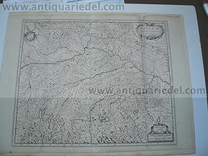
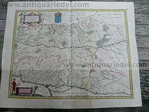
BAVARIAE Superioris et Inferioris, anno 1650, Janssonius J. "Bav
Published by Janssonius Jan,1588-1664, 1664
Hardcover. Condition: very good. BAVARIAE Superioris et Inferioris, anno 1650, Janssonius J. "Bavariae Superioris et Inferioris nova descriptio." Johannes Janssonius (*1588 - 1664) Antike Landkarte Janssonius um 1650 Deutschland, Bayern Titel: Bavariae Superioris et Inferioris nova descriptio Landkarte von Bayern bei J. Janssonius. Zeigt die Gegend zwischen Augsburg, Salzburg, Passau und Amberg. Blattma�: 52x62 cm., alt auf Tr�gerkarton aufgezogen, Fehlstelle an der oberen rechten Kartusche fachm�nnisch nachgezeichnet.
-
Alsatia Superior cum Suntgoia et Brisgoia"anno 1647, Janssonius
Published by Janssonius Jan,1588-1664, 1664
Hardcover. Condition: very good. Alsatia Superior cum Suntgoia et Brisgoia"anno 1647, Janssonius Erscheinungsdatum: 1647 Kupferstich-Karte, Janssonius, 1647. 36 x 47,5 cm. Links unten Titelkartusche. Mit franz�sischem R�ckentext. Rechts unten Vermerk "Per Gerardum Mercatorem Cum Privilegio". Links unten Meilenzeigerkartusche, daneben Vermerk "Amsterdami Apud Ioannem Ian�onium". Westorientierte Karte, Rheinlauf von Bad S�ckingen bis Kappel, Baden mit dem Breisgau, Oberelsass, Schwarzwald. Gedruckt auf dickem Papier, breitrandig, etwas fleckig, wenige kleine Wurml�chlein an der Mittelfalz, mit geringem Bildverlust.
-

Querci-Cahors-Montauban, anno 1640, map, french text on verso
Published by Janssonius Jan,1588-1664, 1664
Hardcover. Condition: very good. Querci-Cahors-Montauban, anno 1640, map, french text on verso, size of the leaf: 48x56 cm., little waterstained.
-
Hardcover. Condition: very good. Comitatus Bentheim et Steinfurt, anno 1647, Janssonius Jan, Kupferkarte, Blattma�: 50x60 cm., gedruckt auf dickem Papier, breitrandig, bis auf einige reparierte Wurmg�nge an der Mittelfalz (minimaler Bildverlust) gut erhalten. Ostorientierte Karte, sehr sch�n zu erkennen die damaligen Postkutschenverbindungen.
-
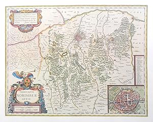
Bayern auf alten Landkarten aus dem Novus Atlas Absolutissimus von Johann Jansson.
Published by M�nchen, Battenberg 1978 (ca.), 1978
Seller: Buch- und Kunst-Antiquariat Flotow GmbH, Ottobrunn, Germany
Seller rating 5 out of 5 stars
Der historische und kulturelle Hintergrund des Atlas Novus ist der Konkurrenzkampf zwischen den beiden Amsterdamer Landkartenverlegern Hondius-Jansson und Joan Blaeu. Amsterdam war damals die Hauptstadt der noch jungen Republik der Vereinigten Niederlande nach der Losl�sung der protestantischen Provinzen von Spanien. - In dieser vollst�ndigen Faksimile-Ausgabe enthalten sind mehrere Karten von Deutschland, Bayern, Franken, Umgebung von N�rnberg, Schwaben, der Rheinpfalz, Tirol, Salzburg, der Donaul�nder, Henneberg und Wertheim. - In sauberer Erhaltung 14 (1 gefalt.) farbige Landkarten-Faksimiles, 22 Bl�tter �berwiegend faksimiliereter Begleittext Original-Halbleinen mit Buntpapierbezug, Imp.Folio.
-

Hardcover. Condition: very good. Schweiz, Karte, anno 1640, Janssonius Kupferkarte, verlegt von Janssonius, ca. anno 1640, alt auf Karton hinterlegt, Blattma�. 43x57 cm., diverse Fehlstellen in der Falte fachm�nnisch nachgezeichnet, siehe Fotos.
-

Hardcover. Condition: very good. Otranto/Salentina,anno 1630, Janssonius J., coppermap Coppermap, edited by Hondius/Janssonius, anno 1630, mounted on thick paper, cracked, brownish, little loss, size of the leaf: 43 x 57 cm. CERTIFICATE OF AUTHENTICITY: WE GARANTEE AN ORIGINAL MAP, EDITED BY JANSSONIUS IN THE YEAR ANNO DOMINI 1630. Petra Riedel, antiquarian bookseller, Germany, Am Rod 27.
-
Hardcover. Condition: very good. Bressia vulgo Bresse, anno 1650, map, Janssonius Jan Coppermap, edited by Janssonius J., contemporary colours, german text on verso, size of the leaf: 45x56 cm., good condition.
-

Hardcover. Condition: very good. Ducatus Silesiae Glogani, anno 1657, Janssonius J., edited in Atlas Novus, french edition, size of the sheet: 50x60 cm., printed on thick paper, wide margins, little foxed, small restorations on centerfold.
-
Hardcover. Condition: very good. Lionnois, anno 1650, map Janssonius J. "Lionnois, Forest, Beauiolois et Masconnois" Size of the leaf: 45x56 cm. Detailed original hand coloured map of the area between the Pays de Bresse on the North and the Lyonnais printed by Joan Jansson. Showing the towns Lyon and Vienne at the Rivers Sa�ne and Rhone. Oriented to the West. Lionnois, anno 1650, map Janssonius J. No text on verso.
-
L�neburg,Hamburg,Bremen, Elbe-Weser, anno 1650, Janssonius J.
Published by Janssonius Jan,1588-1664, 1664
Hardcover. Condition: very good. "DVCATVS LVNEBVRGENSIS Adiacentiump. regionum delineatio Auctore IOHANNE MELLINGERO" Altkolorierte Kupferkarte von Janssonius, anno 1650, franz. R�ckentext. Sehr guter Erhaltungszustand, breitrandig. Blatt: 48x56 cm.
-
Braunschweig-Norddeutschland, anno 1630, Hondius, altkoloriert:
Published by Janssonius Jan,1588-1664, 1664
Hardcover. Condition: very good. Braunschweig-Norddeutschland, anno 1630, Hondius, altkoloriert: BRAVNSWYCK & MEYDBVRG cum ceteris.", nach der Mercatorkarte, Blattma�: 44x54 cm., gering gebr�unt. Die Karte wird begrenzt durch den Lauf der Weser im Westen, Gotha, Erfurt, Jena im S�den, Brandenburg, Belzig, Wittenberg im Osten und den Kreis L�neburg/Altmark im Norden. Mit franz. R�ckentext.
-
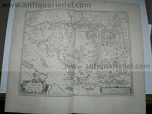
Hardcover. Condition: very good. Lusatia Superior, anno 1657, Janssonius aus Atlas Novus, franz. R�ckentext, Blattma�: 50x60 cm., breitrandig, gering gebr�unt. Drei kleine Wurml�chlein. Dekorative Spezialkarte der gesamten Oberlausitz bis Muskau, Sagan, Lauban und Kamenz. Im S�dwesten die Elbe mit Bad Schandau, Pirna und Dresden.
-

Hardcover. Condition: very good. Hassia Landgraviatus, anno 1647, Janssonius Jan, franz. R�ckentext, Blatt: 50x60 cm., gedruckt auf dickem Papier, gering gebr�unt, einige wenige Wurml�chlein an der Mittelfalz.
-

Hardcover. Condition: very good. Braunschweig-L�neburg, anno 1647, Karte, Janssonius Serenissimo Principi ac domino D Christiano duci Brunsvicensi et Luneburgensi Gebiet Celle, Halberstadt, Hann.- M�nden, Minden. Franz. R�ckentext, Blatt: 50x60 cm., gedruckt auf dickem Papier, sauber und breitrandig, bis auf einige wenige (3-5 St.) kleine Wurml�chlein an der Mittelfalz perfekt erhalten.
-

Hardcover. Condition: very good. Bourgogne, Lac Geneve, anno 1660, map Janssonius Decorative map of the Burgundy region roughly between Langres, Geneva, Lyon and Nevers. Fully engraved to show rivers, mountains, forests and cities. Edited by Janssonius, approx. anno 1660, old colours, no text on verso. Size of the leaf: 45x56 cm.
-

Hardcover. Condition: very good. Galliae Veteris, Generalmap, anno 1650, Janssonius, size of the leaf: 50x60 cm., centerfold little brownish.
-

Hardcover. Condition: very good. Coppermap, edited by Janssonius J, anno 1640, verso blank, size of the leaf: 45x56 cm., Restoration on below centerfold.
-

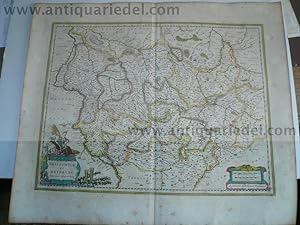
Principatus Anhaltinus et Magdeburgensis, anno 1647, Janssonius
Published by Janssonius Jan,1588-1664, 1664
Hardcover. Condition: very good. Principatus Anhaltinus et Magdeburgensis, anno 1647, Janssonius, ostorientierte Kupferkarte, Blattma�: 50x60 cm., gedruckt auf dickem Papier, breitrandig und sauber, bis auf minimalsten reparierten Wurmfra� an der Mittelfalz ausgezeichnet erhalten. Franz. R�ckentext. Die Karte wird begrenzt durch Wittenberg im S�dosten, Brandenburg im Osten, Werden, Seehausen im Norden und durch den Harz im Westen.