Homman (31 results)

Published by Milano, Il Saggiatore 1967 1967
- Hardcover
Seller: Libreria Gullà, roma, ItalyLibreria Gullà
Contact seller5-star sellerIn-8° gr. pp. 224 con 55 tav. a col. con le ill. applicate, 19 ill. in nero, 37 dis. e 1 carta geog. leg. in tela edit. priva della sovrac.

Published by R&B, Lisse - vierde druk 2002 2002
- Hardcover
Seller: Handled With Care, Bocholt, BelgiumHandled With Care
Contact seller3-star sellerHardcover/Hardback. Condition: New. In zeer goede staat. Ongelezen. Hardcover. Rijkelijk geà llustreerd. Groot boek.

Published by VANDER EDITEUR 1966
- Softcover
Seller: Le-Livre, SABLONS, FranceLe-Livre
Contact seller5-star sellerCondition: Used - Near fine
£ 22.96
£ 36.29 shippingShips from France to U.S.A.Quantity: 1 available
Add to basketCouverture souple. Condition: bon. R240009378: 1966. In-8. Broché. Bon état, Couv. convenable, Dos satisfaisant, Intérieur frais. 93 pages. Nombreuses illustrations en noir et blanc, dans le texte. . . . Classification Dewey : 600-TECHNIQUE (SCIENCES APPLIQUEES).
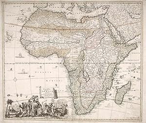
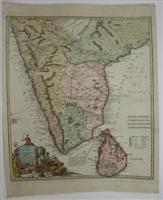
[Africa] Accuratissima Totius Africae Tabula in Lucem Producia Per Tacobum de Sandrart Norimbergae
SANDRART, Jacob von (1630-1708) engraved by Johann Baptist HOMMAN (1663-1724)
Published by J. von Sandart, Nuremburg 1675
- Hardcover
- Map
Seller: Donald A. Heald Rare Books (ABAA), New York, U.S.A.Donald A. Heald Rare Books (ABAA)
Contact seller5-star sellerCopper engraving with early colour. Printed on laid paper. Title in manuscript ink on verso of sheet. Cleveland Historical Society collection stamp on verso of sheet. Numerous tears and creases in outside margins, which have been expertly repaired. Center fold has been strengthened. An early map of Africa by the great mapmaker J…acob von Sandrart, engraved by Homann. Sandrart's stunning map of Africa is a close copy of Fredrik de Wit's map, 'Nova Africa Descriptio' published in 1660. With the prime meridian running through Ferro Island, the map is typical of late seventeenth century maps of Africa. Like other maps of the period, Sandrart has included a highly decorative and informative cartouche in the lower left corner of the sheet. Homann's continental cartouches aspired to convey the natural history as well as the costume and manner of life of the human inhabitants. Here, while a woman peacefully nurses her baby in a hammock, a native chief stares out at the viewer from under the shade of a large umbrella. On the right side of the vignette, two riders on horseback, one with a cutlass and one with a decaptitated head, ride by a river where one man is attacking another with his sword. Among the humans are a lion, a snake, a reptile of some sort and another fox-like animal. Although the map repeats De Wit's decorations, it relies on Ptolemy for its description of the Nile basin. It is to some degree remarkable that seventeenth century maps of the interior of Africa were filled with geographical features and named locations, since there had been very little European exploration of the interior at this date. European trade took place at specific locations along the coast and almost nothing was known about the interior of the dark continent except through rumor. This is a fascinating map by Sandrart and one of only two maps engraved by Homann before 1690. Born at Frankfurt-on-Main, Jacob von Sandrart was one of the most esteemed mapmakers in Nuremberg at the close of the seventeenth century. He learned his trade from his uncle Joachim von Sandrart and from Cornelius Danckerts. As with this impressive map, all of Sandrart's charts are filled with a wealth of decorative details and highly ornate cartouches.
Language: French
Published by Chez Daumont, à Paris 1757
Seller: Bouquinerie L'Ivre Livre, FOIX, FranceBouquinerie L'Ivre Livre
Contact seller4-star sellerCondition: Used - Good
£ 178.00
£ 14.34 shippingShips from France to U.S.A.Quantity: 1 available
Add to basketCarte Entoilée. Condition: Etat Satisfaisant. Carte dressée sur les mesures géométriques de Muller, Vieland et autres, et soumise aux observations astronomiques par Tobie Majer, mathématicien, et publiée par les héritiers d'Homanne. Une carte gravée sur cuivre et aux frontières coloriées d'environ 56x46 centimètres, ornée des bl…asons des quatre états; échelles graduées en milles d'Allemagne, milles communs de Silésie, grands milles de Silésie et ordinaires de Bohême, lieues communes de France, toises de Paris. Présente une grande déchirure le long d'un pli vertical sur 22 centimètres et de petites déchirures au croisement des plis verticaux et des plis horizontaux. L'impression reste très fraiche et l'avers de la carte n'est presque pas taché. Poids: 50 grammes.
Published by Germany 1731
- Map
Seller: Alexandre Antique Prints, Maps & Books, Toronto, CanadaAlexandre Antique Prints, Maps & Books
Contact seller4-star sellerSize : 142x209 (mm), 5.59x8.23 (Inches), Hand Colored Very Good, backed on acid free tissue paper for long term preservation.
Published by Germany 1731
- Map
Seller: Alexandre Antique Prints, Maps & Books, Toronto, CanadaAlexandre Antique Prints, Maps & Books
Contact seller4-star sellerCondition: Used
£ 173.79
£ 4.50 shippingShips from Canada to U.S.A.Quantity: 1 available
Add to basketSize : 137x228 (mm), 5.39x8.98 (Inches), Hand Colored Very Good, backed on acid free tissue paper for long term preservation.
Published by Germany 1731
- Map
Seller: Alexandre Antique Prints, Maps & Books, Toronto, CanadaAlexandre Antique Prints, Maps & Books
Contact seller4-star sellerCondition: Used
£ 173.79
£ 4.50 shippingShips from Canada to U.S.A.Quantity: 1 available
Add to basketSize : 142x144 (mm), 5.59x5.67 (Inches), Hand Colored Very Good, backed on acid free tissue paper for long term preservation.

Published by J.B. Homann (Noribergae) ca. 1715, Nürnberg 1715
- Map
Seller: Antiquariat Reinhold Berg eK Inh. R.Berg, Regensburg, GermanyAntiquariat Reinhold Berg eK Inh. R.Berg
Contact seller5-star sellerCondition: Used
£ 173.55
£ 20.74 shippingShips from Germany to U.S.A.Quantity: 1 available
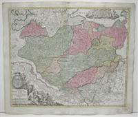
Add to basketCopper engraving, original color. Original antique copper engraving in full contemporary hand color in wash and outline when published. Large decorative, administrative map of Lower Austria with the districts of Unterwienerwald (= industrial district), Oberwienerwald (= Mostviertel), Obermanhartsberg (= Waldviertel) and Unterman…hartsberg (= Weinviertel). The map is equipped with many place names, rivers, mountains, etc. In the lower right corner we find a large figurative title cartouche and scale cartouche. Johann Baptist Homann (20 March 1664 1 July 1724) was a German geographer and cartographer, who also made maps of the Americas. Homann was born in Oberkammlach near Kammlach in the Electorate of Bavaria. Although educated at a Jesuit school, and preparing for an ecclesiastical career, he eventually converted to Protestantism and from 1687 worked as a civil law notary in Nuremberg. He soon turned to engraving and cartography; in 1702 he founded his own publishing house. Homann acquired renown as a leading German cartographer, and in 1715 was appointed Imperial Geographer by Emperor Charles VI. Giving such privileges to individuals was an added right that the Holy Roman Emperor enjoyed. In the same year he was also named a member of the Prussian Academy of Sciences in Berlin. Of particular significance to cartography were the imperial printing privileges (Latin: privilegia impressoria). These protected for a time the authors in all scientific fields such as printers, copper engravers, map makers and publishers. They were also very important as a recommendation for potential customers. In 1716 Homann published his masterpiece Grosser Atlas ueber die ganze Welt (Grand Atlas of all the World). Numerous maps were drawn up in cooperation with the engraver Christoph Weigel the Elder, who also published Siebmachers Wappenbuch. Homann died in Nuremberg in 1724. He was succeeded by his son Johann Christoph (1703-1730). The company carried on upon his death as Homann heirs company, managed by Johann Michael Franz and Johann Georg Ebersberger. After subsequent changes in management the company folded in 1852.[1] The company was known as "Homann Erben", "Homanniani Heredes", or "Heritiers de Homann" abroad. (Wikipedia) In excellent condition. 48 x 57 cm (19 x 22,5 inches).
Published by Homann., Nurnberg. 1775
Seller: Libreria M. T. Cicerone, Roma, ItalyLibreria M. T. Cicerone
Contact seller5-star sellerCondition: Used
£ 160.20
£ 39.75 shippingShips from Italy to U.S.A.Quantity: 1 available
Add to basketCarta geografica, cm. 60 x 49 ca., colorata. Riquadro in alto a sin. raffigurante la parte settentrionale della Polonia. Pregevole cartiglio in alto a destra, con scala.
Published by Germany 1731
- Map
Seller: Alexandre Antique Prints, Maps & Books, Toronto, CanadaAlexandre Antique Prints, Maps & Books
Contact seller4-star sellerCondition: Used
£ 212.41
£ 4.50 shippingShips from Canada to U.S.A.Quantity: 1 available
Add to basketSize : 141x130 (mm), 5.55x5.12 (Inches), Hand Colored Very Good, backed on acid free tissue paper for long term preservation.
Published by Germany 1731
- Map
Seller: Alexandre Antique Prints, Maps & Books, Toronto, CanadaAlexandre Antique Prints, Maps & Books
Contact seller4-star sellerCondition: Used
£ 212.41
£ 4.50 shippingShips from Canada to U.S.A.Quantity: 1 available
Add to basketVeracruz, also known as Heroica Veracruz, is a Mexican port city on the Gulf of Mexico coast in the state of Veracruz., Size : 144x133 (mm), 5.67x5.24 (Inches), Hand Colored Very Good, backed on acid free tissue paper for term preservation.
Published by Germany 1731
- Map
Seller: Alexandre Antique Prints, Maps & Books, Toronto, CanadaAlexandre Antique Prints, Maps & Books
Contact seller4-star sellerCondition: Used
£ 289.65
£ 4.50 shippingShips from Canada to U.S.A.Quantity: 1 available
Add to basketSize : 140x143 (mm), 5.51x5.63 (Inches), Hand Colored Very Good, backed on acid free tissue paper for long term preservation.
Published by Germany 1731
- Map
Seller: Alexandre Antique Prints, Maps & Books, Toronto, CanadaAlexandre Antique Prints, Maps & Books
Contact seller4-star sellerCondition: Used
£ 366.89
£ 4.50 shippingShips from Canada to U.S.A.Quantity: 1 available
Add to basketSize : 305x490 (mm), 12.01x19.29 (Inches), Original Hand Coloring Very Good, backed on acid free tissue paper for long term preservation.

Published by Amsterdam 1738
- Map
Seller: Alexandre Antique Prints, Maps & Books, Toronto, CanadaAlexandre Antique Prints, Maps & Books
Contact seller4-star sellerCondition: Used - Very good
£ 386.20
£ 4.50 shippingShips from Canada to U.S.A.Quantity: 1 available
Add to basketCondition: Very Good. Size : 568x500 (mm), 22.375x19.625 (Inches), Original Hand Coloring.
Published by Amsterdam 1738
Seller: Alexandre Antique Prints, Maps & Books, Toronto, CanadaAlexandre Antique Prints, Maps & Books
Contact seller4-star sellerCondition: Used
£ 386.20
£ 4.50 shippingShips from Canada to U.S.A.Quantity: 1 available
Add to basketSize : 487x580 (mm), 19.125x22.875 (Inches), Original Hand Coloring Very Good; two very light dampstains on the lower margin (on either side of the fold), not entering the image; slight darkening of the lower right corner of the map.
Published by Amsterdam 1738
Seller: Alexandre Antique Prints, Maps & Books, Toronto, CanadaAlexandre Antique Prints, Maps & Books
Contact seller4-star sellerCondition: Used
£ 386.20
£ 4.50 shippingShips from Canada to U.S.A.Quantity: 1 available
Add to basketSize : 518x590 (mm), 20.375x23.25 (Inches), Original Hand Coloring Very Good; some very light occasioanl browning; mainly on the right and upper margins.
Published by Amsterdam 1738
Seller: Alexandre Antique Prints, Maps & Books, Toronto, CanadaAlexandre Antique Prints, Maps & Books
Contact seller4-star sellerCondition: Used
£ 386.20
£ 4.50 shippingShips from Canada to U.S.A.Quantity: 1 available
Add to basketSize : 497x587 (mm), 19.5x23.125 (Inches), Original Hand Coloring Very Good; light dampstain on lower margin.
Published by Nuremberg 1747
- Map
Seller: Alexandre Antique Prints, Maps & Books, Toronto, CanadaAlexandre Antique Prints, Maps & Books
Contact seller4-star sellerCondition: Used - Very good
£ 463.44
£ 4.50 shippingShips from Canada to U.S.A.Quantity: 1 available
Add to basketCondition: Very Good. Size : 495x495 (mm), 19.5x22.625 (Inches), Original Hand Coloring.
Published by Amsterdam 1738
- Map
Seller: Alexandre Antique Prints, Maps & Books, Toronto, CanadaAlexandre Antique Prints, Maps & Books
Contact seller4-star sellerCondition: Used
£ 463.44
£ 4.50 shippingShips from Canada to U.S.A.Quantity: 1 available
Add to basketSize : 490x583 (mm), 19.25x23 (Inches), Original Hand Coloring Very Good; one light dampstain on lower left margin. Some light darkening of the lower right corner of the page.
 More images
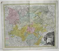
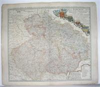
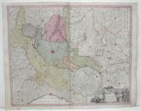
Published by Augsbourg, s.d. (1730), Nuremberg, sans date (1730). 1730
Seller: Librairie BERTRAN, ROUEN, FranceLibrairie BERTRAN
Contact seller5-star sellerCondition: Used
£ 460.57
£ 43.20 shippingShips from France to U.S.A.Quantity: 1 available
Add to basketQuatre cartes entoilées, 60 x 54 cm, repliées dans un étui, dont trois en couleurs. Etui en basane fauve d'époque, roulette dorée sur les plats, dos orné avec le titres des cartes. Saxoniae Superioris Circulus (noir) et Electoratus sive Marchia Brandeburgensis (couleurs) par Seuter; Principatus Isenacensis (couleurs) et Episcopa…tus Hidesiensis (couleurs) par Homman. Matthaeus Seutter (1678-1757) cartographe et graveur allemand , fût un contemporain et rival de Homann. Il a été apprenti chez Homann et a créé sa propre affaire en 1707 à Augsbourg. Il a produit plusieurs atlas comprenant le "Tabulae Geographicae", "l'atlas Novus", et "l'atlas Minor". Ses cartes sont très semblables (du moins dans le style), à celles de Homann. Bel ensemble de cartes allemandes en parfait état dans leur étui d'époque (usagé).

Published by Nuremberg . 1710
- Map
Seller: Robert Frew Ltd. ABA ILAB, London, United KingdomRobert Frew Ltd. ABA ILAB
Contact seller5-star sellerCondition: Used
£ 500.00
£ 10.00 shippingShips from United Kingdom to U.S.A.Quantity: 1 available
Add to basketOriginal double-page copper-engraved map with full original hand-colour, embellished with two vignettes, one with additional map showing the path of the Israelites from Egypt to Canaan. Generally a very good copy with excellent original hand-colour. Decorative map of the Holy Land, published by J.B. Homann in Nuremberg. The map…combines modern geographical information with place names drawn from Biblical history, specifically, the Exodus and the settlement of the Twelve Tribes of Israel. It depicts the Mediterranean from Sidon (in modern-day Lebanon) to Alexandria (not named but marked with Pompey's Pillar). The territories of the Tribes of Israel are marked, appearing on both sides of the Jordan. Mountains and forest regions are illustrated pictorially. Intriguingly, the Dead Sea contains the ruins of Sodom, Gomorrah, Adama, and Seboim all destroyed for their sins. The map is superbly engraved. with Biblical vignettes both in the title cartouche and the lower right. The title cartouche is flanked with putti, several of whom are fluttering about the Ark of the Covenant, half-obscured by clouds. At the base of the cartouche. Moses receives the Ten Commandments from the Burning Bush - meanwhile, in the background, Israelites worship the Golden Calf. In the lower right is an inset map showing the path of the Israelites from Egypt to Canaan. Moses and Aaron consult the map. In the background, two of the dozen spies sent by Moses march by with a massive bunch of grapes set on their shoulders.
 More images
Published by Paris Hubert Jaillot 1695 1695
- Map
Seller: Harrison-Hiett Rare Books, Richelieu, FranceHarrison-Hiett Rare Books
Contact seller4-star sellerCondition: Used
£ 12,000.00
£ 30.24 shippingShips from France to U.S.A.Quantity: 1 available
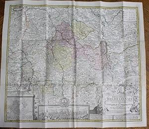
Add to basketA marvelous convolute atlas, put together and bound between 1695 and 1757, with the majority of the maps being printed around 1696-1700. The atlas is in full leather, folio sized (53cm x 38cm). The maps themselves are all either double page or more (with multiple folds). The leather binding is in good order, with some rubbing, a… little chipping to the head and tail of the spine, and slight cracking to the spine edge. there is a leather label "Cartes / Topog / Plans" to the spine. Inside, the maps and engravings are in good, clean condition, without any significant damage. Some have some staining to the blank verso. A lovely item. The atlas has an engraved frontis portrait of Jaillot, and the engraved title page of the Atlas François (Nb. This is a selection from this atlas, not the complete atlas). Then follow 54 double page, folio maps, all with hand colouring (either in outline or more). A complete listing is below, but a summary is: Hubert Jaillot, Atlas François, 18 double maps; Guillaume de L'Isle, four maps of French Diocese; 19 towns and regions by Homman, mainly in Germany; Six maps of Swiss cantons by Vindel; seven miscellaneous maps, including town plans of vienna and Berlin, a battle map (the defense of Prague), Gibraltar and the Isle of Wight. A total of 54 double maps. Complete listing is in subject gathering, rather than the order in the atlas itself: Atlas François, contenant les Cartes Géographiques dans lesquelles sont très exactement remarquez les Empires, Monarchies, Royaumes et Estats de l'Europe, de l'Asie, de l'Afrique et de l'Amerique: avec les Tables et Cartes Particulières de France, de Flandre, septentrionale d'Allemagne, d'Espagne et d'Italie. Hubert Jaillot, Geographe du Roy, 1695. This atlas is incomplete and contains 17 maps of French dioceses and other areas by Hubert Jaillot. All maps are landscape with a page size of 51 x 66cm and larger when additional folds exist, Frontispiece A: Full page image of Alexius Hubertus Jaillot, 1695 / Frontispiece B: Full page bearing the following description and engraved image of a globe held up in triumph and inscribed « ATLAS FRANCOIS, contenant les Cartes Géographiques dans lesquelles sont très exactement remarquez les Empires, Monarchies, Royaumes et Estats de l'Europe, de l'Asie, de l'Afrique et de l'Amerique: avec les Tables et Cartes Particulières de France, de Flandre, septentrionale d'Allemagne, d'Espagne et d'Italie. Hubert Jaillot, Geographe du Roy, 1695 » / Carte Particulière du Canal de la riviere d'Eure, depuis Pontgouin a Versailles. Two separate maps, each with a fold, both by Hubert Jaillot, dated 169. The first from Pontgouin to Houdreville. / Carte Particulière du Canal de la riviere d'Eure, depuis Pontgouin a Versailles. Two separate maps, each with a fold, both by Hubert Jaillot, dated 169. The second from Houdreville to Versailles. / Partie septentrionale de l'évêché de Chartres, by Hubert Jaillot, dated 169. / Partie méridionale de l'évêché de Chartres, by Hubert Jaillot, dated 169. / L'evesche de Nantes, by Hubert Jaillot, dated 169. / Diocese de Castres, by Hubert Jaillot, dated 1700 / Pays qui sont situés entre le Rhein, La Saare, La Moselle et la Basse Alsace, with a very small fold, by Jaillot, 1693 / Second page of same map as above, with a very small fold. / Third page of same map as above, with a very small fold. / Fourth page of same map as above, with a very small fold. / Fifth page of same map, with two large folds. Left and right. / Partie Occidentale du Temporel de l'Archevesche et Eslectorat de Trèves (Trier in Rhineland), by Jaillot, 1694. / Partie Orientale du Temporel de l'Archevesche et Eslectorat de Trèves, by Jaillot, 1694. / Partie Occidentale du Palatinat et Eslectorat du Rhein, by Jaillot, 1694. Partie Orientale du Palatinat et Eslectorat du Rhein, by Jaillot, 1694. / Partie Occidentale du Temporel de l'Archevesche et Eslectorat de Mayence (Mainz in Rhineland), by Jaillot, 1694. / Partie Orientale du Temporel de l'Archevesche et Eslectorat de Mayence, by Jaillot, 1694. / Diocese de Toulouse, Hubert Jaillot, 1695. MAPS COLLECTED FROM OTHER SOURCES Four maps of French Dioceses, all by Guillaume de L'Isle: Carte Topographique du Diocèse de Senlis, by Guillaume de l'Isle, 1709 / Diocèse de Beauvais, by Guillaume de l'Isle, 1710 / Diocese de Narbonne, incl inset small town plan of Narbonne, by Guillaume d l'Isle, 1704 / Diocese of Beziers, including inset small town plan of Beziers, by Guillaume de l'Isle, 1708. Maps of towns and regions, mainly in Germany, by Joh. Chr. Homman (whose name occurs with variants): Comitatus Hanau, with view of Hanau, by Joh. Chr. Hommano, Nurnberg, 1708; with note to the reader, 1728. / Frankfurt am Main mit ihrem gebiet, with three view of Frankfurt town, cathedral interior and market, by Joh. Baptist Homann in Nurnberg, nd. / Principatus et Episcopatus Herbipolensis, (Wurzburg) by Joh. Bapt. Homman, nd. / Principatus et Episcopatus Bambergensis, (Bamberg) by Jo Bapt. Hommano, nd. / Principatus Gotha, Coburg et Altenburg, with small view of Gotha, by Joh. Baptista Homanno, nd. / Episcopatus Hildesiensis, with small view of Hildesheim, by Joh. Baptist Homanni, nd. / Frisia Orientalis, with small plan of Emden, by Joh. Christoph. Homanni, 1730. / Archiepiscopatus Salisburgensis (Salzburg, Austria), by Joh. Bapt. Homann, nd. / Ducatus Wurtenbergici (Wurtemburg, Black Forest), with three large folds, and with small views of Stuttgart & Tubingen, crests of 36 towns, by Joh. Baptista Homanni, 1710. Size: 62 x 99cm. / Provincia Brisgoia (Brisgau, Black Forest), by Joh. Bapt. Homann, 1718. / Insulae et Principatus Rugiae (Riga? on the Baltic), Joh. Baptista Homanno, nd. / Stadt Hamburg samt ihrer Gegend, with large view of Hamburg city, by Joh. Bapt. Homann, nd. / Die Gegend um Prag Prag and surroundings, with small fold, by the inheritors of the Homan estate, 1742. / Plan de la ville et Forteresse de Luxembourg, hand-coloured, by the inheritors of the Hom.
Published by Nuremburg 1733
- Map
Seller: Alexandre Antique Prints, Maps & Books, Toronto, CanadaAlexandre Antique Prints, Maps & Books
Contact seller4-star sellerCondition: Used - Very good
£ 772.39
£ 4.50 shippingShips from Canada to U.S.A.Quantity: 1 available
Add to basketCondition: Very Good. Size : 565x500 (mm), 22.25x19.625 (Inches), Hand Colored, 0.

Published by Nuremburg 1731
- Map
Seller: Alexandre Antique Prints, Maps & Books, Toronto, CanadaAlexandre Antique Prints, Maps & Books
Contact seller4-star sellerCondition: Used
£ 1,544.79
£ 4.50 shippingShips from Canada to U.S.A.Quantity: 1 available
Add to basket(Stolen), Size : 485x590 (mm), 19.125x23.25 (Inches), Hand Colored Very Good, left margin has been extended, laid on acid free paper for long term preservation.
Published by Nurmburg 1735
- Map
Seller: Alexandre Antique Prints, Maps & Books, Toronto, CanadaAlexandre Antique Prints, Maps & Books
Contact seller4-star sellerCondition: Used - Very good
£ 965.49
£ 4.50 shippingShips from Canada to U.S.A.Quantity: 1 available
Add to basketCondition: Very Good. Size : 515x610 (mm), 20.25x24 (Inches), Original Hand Coloring.

Published by Paris 1731
- Map
Seller: Alexandre Antique Prints, Maps & Books, Toronto, CanadaAlexandre Antique Prints, Maps & Books
Contact seller4-star sellerCondition: Used
£ 965.49
£ 4.50 shippingShips from Canada to U.S.A.Quantity: 1 available
Add to basketCondition: Very Good, backed on old linen. Highly decorative map of the West Indies with a large cartouche on top incorporating North American Indians and two insets of St.Augustin, Florida and Bay of Panama on top, plus three insets of Mexico City, Vera Cruz and San-Domingo., Size : 590x495 (mm), 23.25x19.5 (Inches), Original O…utline Coloring.

Published by Nuremberg 1748
- Map
Seller: Alexandre Antique Prints, Maps & Books, Toronto, CanadaAlexandre Antique Prints, Maps & Books
Contact seller4-star sellerCondition: Used - Very good
£ 579.30
£ 4.50 shippingShips from Canada to U.S.A.Quantity: 1 available
Add to basketCondition: Very Good. Size : 496x570 (mm), 19.5x22.375 (Inches), Hand Colored.
Published by Nuremberg 1753
- Map
Seller: Alexandre Antique Prints, Maps & Books, Toronto, CanadaAlexandre Antique Prints, Maps & Books
Contact seller4-star sellerCondition: Used
£ 579.30
£ 4.50 shippingShips from Canada to U.S.A.Quantity: 1 available
Add to basketCondition: Excellent. Size : 455x550 (mm), 17.875x21.625 (Inches), Hand Colored.

Published by Nuremberg 1729
- Map
Seller: Alexandre Antique Prints, Maps & Books, Toronto, CanadaAlexandre Antique Prints, Maps & Books
Contact seller4-star sellerCondition: Used
£ 772.39
£ 4.50 shippingShips from Canada to U.S.A.Quantity: 1 available
Add to basketSize : 493x575 (mm), 19.375x22.625 (Inches), Original Hand Coloring Excellent, very slight age toning; very mild foxing on lower fold.


