
Order Total (1 Item Items):
Shipping Destination:

Haakon Holmboe (8 results)
Skip to main search results
Search filters
Product Type
- All Product Types
- Books (8)
- Magazines & Periodicals (No further results match this refinement)
- Comics (No further results match this refinement)
- Sheet Music (No further results match this refinement)
- Art, Prints & Posters (No further results match this refinement)
- Photographs (No further results match this refinement)
- Maps (No further results match this refinement)
- Manuscripts & Paper Collectibles (No further results match this refinement)
Condition Learn more
- New (No further results match this refinement)
- As New, Fine or Near Fine (1)
- Very Good or Good (3)
- Fair or Poor (1)
- As Described (3)
Binding
- All Bindings
- Hardcover (No further results match this refinement)
- Softcover (6)
Collectible Attributes
- First Edition (1)
- Signed (No further results match this refinement)
- Dust Jacket (No further results match this refinement)
- Seller-Supplied Images (1)
- Not Print on Demand (8)
Language (2)
Free Shipping
Seller Location
Seller Rating
-

Chambers Atlas of World History
Language: English
Published by Chambers Harrap Publishers Ltd, 1986
ISBN 10: 0550180079 ISBN 13: 9780550180070
Seller: WorldofBooks, Goring-By-Sea, WS, United Kingdom
Seller rating 5 out of 5 stars

Paperback. Condition: Very Good. The book has been read, but is in excellent condition. Pages are intact and not marred by notes or highlighting. The spine remains undamaged.
-
Chambers Atlas of World History
Language: English
Published by Chambers Harrap Publishers Ltd, 1986
ISBN 10: 0550180079 ISBN 13: 9780550180070
paperback. Condition: Good. No Highlighting or underlining. Some Wear but overall good condition. 100% Satisfaction Guaranteed.
-

Condition: Fine. Used book that is in almost brand-new condition. May contain a remainder mark. Better World Books: Buy Books. Do Good.
-
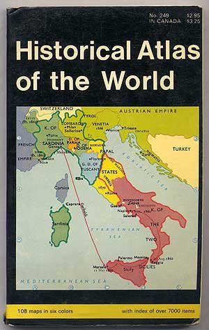
Historical Atlas of the World
Language: English
Published by Barnes & Noble, Inc, New York, 1970
ISBN 10: 0389002534 ISBN 13: 9780389002536
Seller: Ground Zero Books, Ltd., Silver Spring, MD, U.S.A.
Seller rating 5 out of 5 stars
First Edition
Trade paperback. Condition: Good. Berit Lie (Maps) (illustrator). The format is approximately 4.875 inches by 7.75 inches. Unpaginated. 108 maps in six colors. Index with over 7000 items. Cover has some wear, creases, soiling, and chips. Front cover has some weakness. Clearly drawn, uncluttered maps present essentials at a glance. Dramatically shows the movement and progress of history. Contents covers Ancient Times (maps 1 to 31); The Middle Ages (maps 32 to 55); Recent times (Maps 56 to 93); and The Twentieth Century (Maps 94 to 108. Among the topics cartographically illustrated are: Greece during the Persian Wars; Greece during the Peloponnesian War, The Empire of Alexander the Great, the Punic Wars, The Barbarian Migrations and Kingdoms, Expansion of the Papal States, The Crusades, Renaissance Italy, Byzantine Empire, The Exploration of the New World, The Holy Roman Empire, Campaign of Charles XII, Brandenburg-Prussia, Europe in Napoleon's Time, Boer War, Western Front, Eastern Front, and Europe during the Second World War. A historical atlas is a collection of maps and possibly illustrations that depict the historical geography of a particular region at a defined time period. These atlases typically include maps that show the political and cultural boundaries of different states as well as other data, and in some cases illustrations that provide information about important historical events and figures. They may also include timelines, charts, and other information to help readers understand the historical context of the maps. Historical atlases are used by scholars, students, and general readers to study and learn about the past. Some try to present the entire history of the world, such as the Historical Atlas of the World, while others are more specialized, for only one time period or location, such as the Historical Atlas of the American West or The Historical Atlas of China. The first known historical atlas may have been the Parergon by Abraham Ortelius in 1579, which was a supplement to the Theatrum Orbis Terrarum. Presumed First paperback printing of this edition.
-

Hsg. von der K�niglich Norwegischen Botschaft Bonn. 39 S.Quart. Eigenverlag. Bonn. Ausreichend/Acceptable. geheftet/Softcover. Stempel,in schreibmaschine geschrieben,R�cken eingerissen. Bibliotheksexemplar/Library copy. Sprache: deutsch/german.
-

Historical atlas of the world
Language: English
Published by Barnes & Noble (edition ), 1970
ISBN 10: 0389010871 ISBN 13: 9780389010876
Paperback. Condition: Fair. The item might be beaten up but readable. May contain markings or highlighting, as well as stains, bent corners, or any other major defect, but the text is not obscured in any way.
-

Indien og syd�stasien.
Seller: Vangsgaards Antikvariat Aps, Copenhagen, Denmark
Seller rating 5 out of 5 stars
Politikens Forlag, K�benhavn 1977. 608 sider. Illustreret i s/h og farver. Orig. halvfableabind med smudsomslag. Med brugsspor p� smudsomslag. * Et uafh�ngigt supplementsbind til Grimbergs Verdenshistorie.
-
Forlaget for Faglitteratur, K�benhavn 1961-1970. 464+583+528+529+880 sidor. 6 volymer, f�rlagsband med skyddsomslag. 23,5x17 cm. Illustrerad. Bra skick.
