
Order Total (1 Item Items):
Shipping Destination:

Gerhard Mercator (413 results)
Skip to main search results
Search filters
Product Type
- All Product Types
- Books (245)
- Magazines & Periodicals (No further results match this refinement)
- Comics (No further results match this refinement)
- Sheet Music (No further results match this refinement)
- Art, Prints & Posters (30)
- Photographs (No further results match this refinement)
- Maps (138)
- Manuscripts & Paper Collectibles (No further results match this refinement)
Condition Learn more
Binding
Collectible Attributes
Language (7)
Free Shipping
Seller Location
Seller Rating
-
Duisburg, Mercator 1. Aufl. 1980. 303 S. m. Abbildungen. OPbd. m. OU. Gutes Exemplar.
-

geb. 5. M�rz 1512, gest. 2. Dezember 1594. H�ftbild mit Zirkel und Weltkugel.
Published by Holzstich bei Spamer, aus dem Jahr., 1888
Bildgr��e 9,5x8 cm.
-
1 Brustbild, in der Hand die Weltkugel und einen Zirkel haltend, mit einem Artikel "Nach Mercators Projektion" auf zwei Blatt.
Published by Holzstich aus dem Jahr., 1878
Bildgr��e 17x12 cm. Blattgr��e 30x21 cm.
-
Hardcover. Condition: Gut. 4 Karton Buch 253 SS, OKart. (geringe Gebrauchsspuren), innen und aussen sauber und gut mit zahlreichen teils farbigen Abbildungen Gut.
-
Atlas oder kosmographische Gedanken �ber die Erschaffung der Welt und ihre kartographische Gestalt.
Seller: Emile Kerssemakers ILAB, Heerlen, Netherlands
Seller rating 5 out of 5 stars

1994, 209S. Illustriert. Gebunden. Neu!
-
The Mercator Atlas of Europe: Facsimile of the Maps by Gerardus Mercator Contained in the Atlas of Europe, Circa 1570-1572.
Seller: Kloof Booksellers & Scientia Verlag, Amsterdam, Netherlands
Seller rating 4 out of 5 stars

Condition: as new. Edited by Marcel Watelet ; with contributions by James R. Akerman . [et al.] New York : Walking Tree Press, 1998. Paperback. 92 pp. Color & b/w ills. 40x28 cm. With 17 folded Facsimil� maps. In orig. binding in orig. cloth slipcase. Condition : as new copy. ISBN 9780965973571. Keywords : , Atlas.
-
9,0 x 7,0 cm. [SW - Portr�t, Portrait, Gerhard Mercator].
-
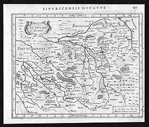
"Le Duche d'Berry" - Berry Bourges Vierzon Boussac Chateauroux carte map Mercator
Language: German
Published by Amsterdam, 1634
Seller: Antiquariat Steffen V�lkel GmbH, Seubersdorf, Germany
Seller rating 5 out of 5 stars
Map
original Kupferstich-Karte von Mercator bei Janssonius aus dem Jahre 1634 Blatt-Masse: ca.19 x16 cm leicht gebr�unt, im Au�enrand leicht fleckig sonst gut erhalten Original! - Kein Nachdruck! - Keine Kopie! Viele alte B�cher, Landkarten, Ansichten und Portraitsin unserem shop. Plus de gravuresdans notre shop. More views, maps, portraits and coat-of-arms in our shop! // Wir, das Antiquariat Steffen V�lkel, kaufen und verkaufen alte B�cher, Handschriften, Zeichnungen, Autographen, Grafiken und Fotografien. Wir sind stets am Ankauf von kompletten Bibliotheken, Sammlungen und Nachl�ssen interessiert. Sprache: Deutsch Gewicht in Gramm: 10.
-
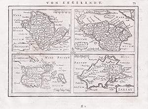
"Anglesey / Garnesay / Iarsay / Wight ol. vectis" - Anglesey Guernsey Jersey Isle of Wight island islands Great Britain Gro�britannien England
Language: French
Published by Amsterdam, Janssonius, 1651
Seller: Antiquariat Steffen V�lkel GmbH, Seubersdorf, Germany
Seller rating 5 out of 5 stars
Map
Blatt-Ma�e: ca. 17,5 x 23 cm -- Original Kupferstich-Karte von Gerard Mercator. R�ckseitig mit deutschem Text. Aus der deutschen Ausgabe des "Atlas Minor" von 1651. - gut erhalten. || Rare original copper engraved map by Gerard Mercator. With German text on verso. From the German edition of the "Atas Minor" from the year 1651. -- in very good condition. || The Flemish engraver and cartographer Jodocus Hondius (15631612), bought Mercator's plates after his death, and published this reduced version of Mercator's folio Atlas sive Cosmographis, and added some 36 of his own maps - a pocketversion - Atlas Minor - which Hondius published together with his partners Cornelius Claesz and Johannes Janssonius. It became a large success, and was translated into several languages and issued in c. 40 editions. // Wir, das Antiquariat Steffen V�lkel, kaufen und verkaufen alte B�cher, Handschriften, Zeichnungen, Autographen, Grafiken und Fotografien. Wir sind stets am Ankauf von kompletten Bibliotheken, Sammlungen und Nachl�ssen interessiert. Sprache: Franz�sisch Gewicht in Gramm: 10.
-

"Norfolciae" - Norfolk England Great Britain Gro�britannien
Language: French
Published by Amsterdam, Janssonius, 1651
Seller: Antiquariat Steffen V�lkel GmbH, Seubersdorf, Germany
Seller rating 5 out of 5 stars
Map
Blatt-Ma�e: ca. 17,5 x 23 cm -- Original Kupferstich-Karte von Gerard Mercator. R�ckseitig mit deutschem Text. Aus der deutschen Ausgabe des "Atlas Minor" von 1651. - teils etwas flecklig, sonst gut erhalten. || Rare original copper engraved map by Gerard Mercator. With German text on verso. From the German edition of the "Atas Minor" from the year 1651. -- partly with some staining, otherwise in very good condition. || The Flemish engraver and cartographer Jodocus Hondius (15631612), bought Mercator's plates after his death, and published this reduced version of Mercator's folio Atlas sive Cosmographis, and added some 36 of his own maps - a pocketversion - Atlas Minor - which Hondius published together with his partners Cornelius Claesz and Johannes Janssonius. It became a large success, and was translated into several languages and issued in c. 40 editions. // Wir, das Antiquariat Steffen V�lkel, kaufen und verkaufen alte B�cher, Handschriften, Zeichnungen, Autographen, Grafiken und Fotografien. Wir sind stets am Ankauf von kompletten Bibliotheken, Sammlungen und Nachl�ssen interessiert. Sprache: Franz�sisch Gewicht in Gramm: 10.
-
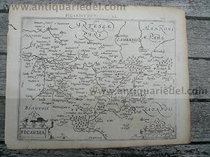
MERCATOR, G./ HONDIUS, J. - Picardia. Picardia., published in Am
Published by Mercator Gerhard, 1512-1594, 1594
First Edition
Hardcover. Condition: very good. MERCATOR, G./ HONDIUS, J. - Picardia. Picardia., published in Amsterdam, 1608 by MERCATOR, G./ HONDIUS, J. Publisher : MERCATOR, G./ HONDIUS, J. Title : Picardia. Published in Amsterdam, 1608. Size : 14x18 cm., little brownish, small wormhole outside of the map. Map centered on the French region of Picardy. From the first French-text edition of Jodocus Hondius' Atlas Minor.
-

"Belgii sive Germaniae Inferioris" - Nederland Netherlands Niederlande Holland
Language: French
Published by Amsterdam, Janssonius, 1651
Seller: Antiquariat Steffen V�lkel GmbH, Seubersdorf, Germany
Seller rating 5 out of 5 stars
Map
Blatt-Ma�e: ca. 17,5 x 23 cm -- Original Kupferstich-Karte von Gerard Mercator. R�ckseitig mit deutschem Text. Aus der deutschen Ausgabe des "Atlas Minor" von 1651. - gut erhalten. || Rare original copper engraved map by Gerard Mercator. With German text on verso. From the German edition of the "Atas Minor" from the year 1651. -- in very good condition. || The Flemish engraver and cartographer Jodocus Hondius (15631612), bought Mercator's plates after his death, and published this reduced version of Mercator's folio Atlas sive Cosmographis, and added some 36 of his own maps - a pocketversion - Atlas Minor - which Hondius published together with his partners Cornelius Claesz and Johannes Janssonius. It became a large success, and was translated into several languages and issued in c. 40 editions. // Wir, das Antiquariat Steffen V�lkel, kaufen und verkaufen alte B�cher, Handschriften, Zeichnungen, Autographen, Grafiken und Fotografien. Wir sind stets am Ankauf von kompletten Bibliotheken, Sammlungen und Nachl�ssen interessiert. Sprache: Franz�sisch Gewicht in Gramm: 10.
-
Weltkarte ad usum navigantium - 3 Teile in einem : 1. [Faltkarte] Nova et avcta orbis terrae descriptio ad vsvm na u�gant�um emendat� accommodata : Weltkarte "zum Gebrauch der Seefahrer" / 2. Begleitheft / 3. Anmerkungen zum Begleitheft, Personenregister.
Seller: Antiquariat Thomas Haker GmbH & Co. KG, Berlin, Germany
Association Member: GIAQ
Seller rating 5 out of 5 stars
Mappe. Condition: Gut. 1 Kt. ; 110 x 68 cm, Mercator-Lineal, 33, [32] S. ; 42 cm. Guter Zustand. 3 Teile in einem: Karte, Beiheft und Anmerkungen (sowie Mercator-Lineal). Bibliotheksexemplar mit Stempeln und Signatur auf Einband. Sonst Seiten sauber. / Good. Ex-library with usual markings. Clean pages. Sprache: Deutsch Gewicht in Gramm: 1010.
-
Germania. - [Farbiger Nachdruck einer Karte aus "Germaniae tabulae geographicae", 1594].
Language: German
Published by o.O: o.V. o.J. (1980??)., 1980
Seller: ANTIQUARIAT Franke BRUDDENBOOKS, L�beck, Germany
Seller rating 5 out of 5 stars
Condition: Gut. 1 Bl. (44 x 64 cm, gefalzt auf 44 x 32 cm), Gro�formatiger farbiger Nachdruck der Germaia-Karte Mercartors "Germaniae tabulae geographicae" von 1594. - Verso mit Erl�uterungstext in lateinischer Sprache. - Original siehe z.B. HT01622813 der Heinrich Heine-Universit�t D�sseldorf. - Exemplar auf festem Papier in Pergamentoptik. - Dekoratives und wohlerhaltenes Exemplar. Wir senden umgehend mit beiliegender MwSt.Rechnung. Sprache: Deutsch Gewicht in Gramm: 1001.
-

Berry Ducatus, anno 1600, map, Mercator, Coppermap, size of the
Published by Mercator Gerhard, 1512-1594, 1594
Hardcover. Condition: very good. Berry Ducatus, anno 1600, map, Mercator, Coppermap, size of the leaf: 40x50 cm. Brownish centerfold, some small wormholes.
-

Vierhundert Jahre Mercator, vierhundert Jahre Atlas : die ganze Welt zwischen zwei Buchdeckeln : eine Geschichte der Atlanten / herausgegeben von Hans Wolff im Auftrag der Bayerischen Staatsbibliothek
Language: German
Published by Weissenhorn, Germany : Anton H. Konrad Verlag, 1995
ISBN 10: 3874373584 ISBN 13: 9783874373586
First Edition
First Edition. Near fine copy in the original publisher's gilt-blocked cloth, edges very slightly toned. Corners sharp with an overall tight, bright and clean impression. Series; Ausstellungskataloge / Bayerische Staatsbibliothek ; 65. Physical description; 382 p. : ill. (some col.), maps, ports. ; 25 x 30 cm. Notes; "Dieses Buch erschien zum 400. Todestag Gerhard Mercators anlasslich einer Ausstellung der Bayerischen Staatsbibliothek vom 5. Aoril 1995 bis 1 Juli 1995" -- t.p. verso. Exhibition is mainly of items from the Bayerische Staatsbibliothek's own collections. Spine title : 400 Jahre Mercator, 400 Jahre Atlas. Bibliography : p. 375. Subjects; Mercator, Gerhard (1512-1594) - Influence - Exhibitions. Mercator, Gerhard (1512-1594) - Anniversaries, etc. - 1994 - Exhibitions. Mercator, Gerhard (1512-1594) - Exhibitions. Bayerische Staatsbibliothek - Map collections - Exhibitions. Atlases - History - Exhibitions. Maps, Early - Exhibitions. Maps - History - Exhibitions. Cartography - History - Exhibitions. History of cartography. - [Literature] - 1995. Atlases. - [Literature] - 1995. Maps - Exhibitions - Germany. Maps - Public collections - Germany. Genres; Bibliography. Catalogue. Illustrated. 5 Kg.
-
Mercator-Hondius-Atlas
Language: German
Published by Reprint-Verl. Leipzig, 2012
ISBN 10: 3826230310 ISBN 13: 9783826230318
Hardcover. Condition: Fair. Ohne Umschlag; Leichte Kratzer / Abnutzungen / Druckstellen. Gerhard Mercator ist eine der beeindruckendsten Personlichkeiten der Renaissance. Seine Globen, die sehr sorgfaltig im Kupferstich ausgefuhrten Karten und die Gesamtkonzeption fur die Zusammenstellung von Atlanten begrunden seinen bis heute nachwirkenden Ruhm. Die grosse Weltkarte von 1569 wird als Mercators Meisterwerk betrachtet, da mit ihr erstmals die Darstellung der Erde in einer winkeltreuen Projektion gelungen ist. Fur die Seefahrt ist diese winkeltreue Projektion, die >Mercator-ProjektionMercator-Hondius-Atlas< in mehreren Auflagen erschien. Nur wenige Ausgaben dieses Atlasses sind koloriert. Das in der Staatsbibliothek zu Berlin vorliegende, hervorragend erhaltene und in den Karten ausserordentlich farbkraftige Exemplar stammt aus dem Jahr 1633.
-
Vienna Austriae. Karte (1595)
Seller: Celler Versandantiquariat, Eicklingen, Germany
Association Member: GIAQ
Seller rating 5 out of 5 stars
Coron, (um 2003). Neuwertiger Faksimiledruck 56 x 41 cm. Farbendruck--- 750 Gramm.
-
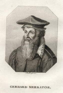
Portr�t. Halbfigur mit Zirkel und Erdkugel. Holzstich aus einer Zeitschrift, r�ckseitig mit Text, 14 x 13 cm, 1870.
Seller: Antiquariat Michael Eschmann, Gro�-Gerau, Germany
Seller rating 5 out of 5 stars
Art / Print / Poster
0. Sprache: Deutschu.
-

Das Globenpaar von Gerhard Mercator Basler Kostbarkeiten; Band 45
Seller: suspiratio - online b�cherstube lic.phil h.b., Basel, Switzerland
Seller rating 4 out of 5 stars
First Edition
Condition: Sehr gut. 1. Auflage. Heft, sehr gut, 44 seiten Language: DEU.
-
[Map] The Countie of Holland
Language: English
Published by T. Cotes for Michael Sparke and Samuel Cartwright, London, 1637
Seller: Lloyd Zimmer, Books and Maps, Chanute, KS, U.S.A.
Seller rating 5 out of 5 stars
Map
Unbound. Condition: Very Good. Dust Jacket Condition: No Dust Jacket. Second English Edition. From Historia Mundi or Mercator's Atlas: Containing his Cosmographicall Description of the Fabricke and Figure of the World. Lately Rectified in Divers Places, as also Beautified and Enlarged with new Mappes and Tables of Jodocus Hondius expanded from the original maps of Gerhard Mercator (translated by Wye Saltonstall). This second edition after the Mercator original was published in 1637 by T. Cotes for Michael Sparke and Samuel Cartwright of London. Approx. 10 x 7 inches (approx. 25.4 x 17.8 cm). Pressed from the original Mercator's plates, though with some revisions of additional details to the plates. "Trimmed into the lower and fore edges of the map leaf (see photos). Light aging, though map image remains clear, clean, and with good color. Originally published without color, hand coloring of such maps was a popular cottage industry at the time, and the coloring seen here would be contemporary to the time of original publications.
-
[Map] The Dukdome of Brabant
Language: English
Published by T. Cotes for Michael Sparke and Samuel Cartwright, London, 1637
Seller: Lloyd Zimmer, Books and Maps, Chanute, KS, U.S.A.
Seller rating 5 out of 5 stars
Map
Unbound. Condition: Very Good. Dust Jacket Condition: No Dust Jacket. Second English Edition. From Historia Mundi or Mercator's Atlas: Containing his Cosmographicall Description of the Fabricke and Figure of the World. Lately Rectified in Divers Places, as also Beautified and Enlarged with new Mappes and Tables of Jodocus Hondius expanded from the original maps of Gerhard Mercator (translated by Wye Saltonstall). This second edition after the Mercator original was published in 1637 by T. Cotes for Michael Sparke and Samuel Cartwright of London. Approx. 10 x 7 inches (approx. 25.4 x 17.8 cm). Pressed from the original Mercator's plates, though with some revisions of additional details to the plates. "Trimmed into the lower and fore edges of the map leaf (see photos). Light aging, though map image remains clear, clean, and with good color. Originally published without color, hand coloring of such maps was a popular cottage industry at the time, and the coloring seen here would be contemporary to the time of original publications.
-
[Map] The Dioecese of Leden
Language: English
Published by T. Cotes for Michael Sparke and Samuel Cartwright, London, 1637
Seller: Lloyd Zimmer, Books and Maps, Chanute, KS, U.S.A.
Seller rating 5 out of 5 stars
Map
Unbound. Condition: Very Good. Dust Jacket Condition: No Dust Jacket. Second English Edition. From Historia Mundi or Mercator's Atlas: Containing his Cosmographicall Description of the Fabricke and Figure of the World. Lately Rectified in Divers Places, as also Beautified and Enlarged with new Mappes and Tables of Jodocus Hondius expanded from the original maps of Gerhard Mercator (translated by Wye Saltonstall). This second edition after the Mercator original was published in 1637 by T. Cotes for Michael Sparke and Samuel Cartwright of London. Approx. 10 x 7 inches (approx. 25.4 x 17.8 cm). Pressed from the original Mercator's plates, though with some revisions of additional details to the plates. "Trimmed into the lower and fore edges of the map leaf (see photos). Light aging, though map image remains clear, clean, and with good color. Originally published without color, hand coloring of such maps was a popular cottage industry at the time, and the coloring seen here would be contemporary to the time of original publications.
-
[Map] The Lordship of Groninga
Language: English
Published by T. Cotes for Michael Sparke and Samuel Cartwright, London, 1637
Seller: Lloyd Zimmer, Books and Maps, Chanute, KS, U.S.A.
Seller rating 5 out of 5 stars
Map
Unbound. Condition: Good. Dust Jacket Condition: No Dust Jacket. Second English Edition. Description: "The Lordship of Groninga [Northern Netherlands]" from Historia Mundi or Mercator's Atlas: Containing his Cosmographicall Description of the Fabricke and Figure of the World. Lately Rectified in Divers Places, as also Beautified and Enlarged with new Mappes and Tables of Jodocus Hondius expanded from the original maps of Gerhard Mercator (translated by Wye Saltonstall). Published in London by T. Cotes for Michael Sparke and Samuel Cartwright (1637) Second edition. Approx. 10 x 7 inch copper engraving with contemporary hand coloring. Top and right margins are closely trimmed, just entering the border along the right-hand portion of the top. Although originally issued without coloring, this hand coloring is contemporary to the date of publication, or very shortly after. Coloring remains fairly bright. Paper is just a little aged.
-
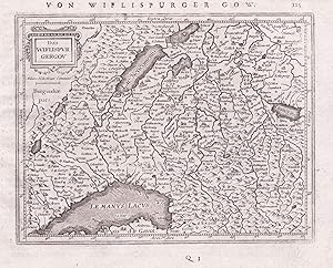
"Das Wiflispurgergou" - Kanton Waadt / Vaud Vierwaldst�ttersee Thuner See Schweiz Suisse Switzerland map Karte carte
Language: German
Published by Amsterdam, Janssonius, 1651
Seller: Antiquariat Steffen V�lkel GmbH, Seubersdorf, Germany
Seller rating 5 out of 5 stars
Map
Blatt-Ma�e: ca. 17,5 x 23 cm -- Original Kupferstich-Karte von Gerard Mercator. R�ckseitig mit deutschem Text. Aus der deutschen Ausgabe des "Atlas Minor" von 1651. - gut erhalten. || Rare original copper engraved map by Gerard Mercator. With German text on verso. From the German edition of the "Atas Minor" from the year 1651. -- in very good condition. || The Flemish engraver and cartographer Jodocus Hondius (15631612), bought Mercator's plates after his death, and published this reduced version of Mercator's folio Atlas sive Cosmographis, and added some 36 of his own maps - a pocketversion - Atlas Minor - which Hondius published together with his partners Cornelius Claesz and Johannes Janssonius. It became a large success, and was translated into several languages and issued in c. 40 editions. // Wir, das Antiquariat Steffen V�lkel, kaufen und verkaufen alte B�cher, Handschriften, Zeichnungen, Autographen, Grafiken und Fotografien. Wir sind stets am Ankauf von kompletten Bibliotheken, Sammlungen und Nachl�ssen interessiert. Sprache: Deutsch Gewicht in Gramm: 10.
-
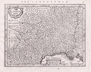
"Languedoc" - Languedoc Cahors Avignon Mercator map Karte gravure carte
Language: German
Published by Amsterdam, Janssonius, 1651
Seller: Antiquariat Steffen V�lkel GmbH, Seubersdorf, Germany
Seller rating 5 out of 5 stars
Map
Blatt-Ma�e: ca. 17,5 x 23 cm -- Original Kupferstich-Karte von Gerard Mercator. R�ckseitig mit deutschem Text. Aus der deutschen Ausgabe des "Atlas Minor" von 1651. - gut erhalten. || Rare original copper engraved map by Gerard Mercator. With German text on verso. From the German edition of the "Atas Minor" from the year 1651. -- in very good condition. || The Flemish engraver and cartographer Jodocus Hondius (15631612), bought Mercator's plates after his death, and published this reduced version of Mercator's folio Atlas sive Cosmographis, and added some 36 of his own maps - a pocketversion - Atlas Minor - which Hondius published together with his partners Cornelius Claesz and Johannes Janssonius. It became a large success, and was translated into several languages and issued in c. 40 editions. // Wir, das Antiquariat Steffen V�lkel, kaufen und verkaufen alte B�cher, Handschriften, Zeichnungen, Autographen, Grafiken und Fotografien. Wir sind stets am Ankauf von kompletten Bibliotheken, Sammlungen und Nachl�ssen interessiert. Sprache: Deutsch Gewicht in Gramm: 10.
-

"Sabaudia" - Savoie Savoia Savoyen Italy Italien Italia Mercator map Karte gravure carte
Language: German
Published by Amsterdam, Janssonius, 1651
Seller: Antiquariat Steffen V�lkel GmbH, Seubersdorf, Germany
Seller rating 5 out of 5 stars
Map
Blatt-Ma�e: ca. 17,5 x 23 cm -- Original Kupferstich-Karte von Gerard Mercator. R�ckseitig mit deutschem Text. Aus der deutschen Ausgabe des "Atlas Minor" von 1651. - gut erhalten. || Rare original copper engraved map by Gerard Mercator. With German text on verso. From the German edition of the "Atas Minor" from the year 1651. -- in very good condition. || The Flemish engraver and cartographer Jodocus Hondius (15631612), bought Mercator's plates after his death, and published this reduced version of Mercator's folio Atlas sive Cosmographis, and added some 36 of his own maps - a pocketversion - Atlas Minor - which Hondius published together with his partners Cornelius Claesz and Johannes Janssonius. It became a large success, and was translated into several languages and issued in c. 40 editions. // Wir, das Antiquariat Steffen V�lkel, kaufen und verkaufen alte B�cher, Handschriften, Zeichnungen, Autographen, Grafiken und Fotografien. Wir sind stets am Ankauf von kompletten Bibliotheken, Sammlungen und Nachl�ssen interessiert. Sprache: Deutsch Gewicht in Gramm: 10.
-

"Eboracum, Lincolnia, Derbia, Staffordia, Notinghamia, Lecestria, Rutlandia, et Norfolcia" - Lincolnshire Norfolk Yorkshire England Leicestershire Humbersida Great Britain Gro�britannien
Language: German
Published by Amsterdam, Janssonius, 1651
Seller: Antiquariat Steffen V�lkel GmbH, Seubersdorf, Germany
Seller rating 5 out of 5 stars
Map
Blatt-Ma�e: ca. 17,5 x 23 cm -- Original Kupferstich-Karte von Gerard Mercator. R�ckseitig mit deutschem Text. Aus der deutschen Ausgabe des "Atlas Minor" von 1651. - gut erhalten. || Rare original copper engraved map by Gerard Mercator. With German text on verso. From the German edition of the "Atas Minor" from the year 1651. -- in very good condition. || The Flemish engraver and cartographer Jodocus Hondius (15631612), bought Mercator's plates after his death, and published this reduced version of Mercator's folio Atlas sive Cosmographis, and added some 36 of his own maps - a pocketversion - Atlas Minor - which Hondius published together with his partners Cornelius Claesz and Johannes Janssonius. It became a large success, and was translated into several languages and issued in c. 40 editions. // Wir, das Antiquariat Steffen V�lkel, kaufen und verkaufen alte B�cher, Handschriften, Zeichnungen, Autographen, Grafiken und Fotografien. Wir sind stets am Ankauf von kompletten Bibliotheken, Sammlungen und Nachl�ssen interessiert. Sprache: Deutsch Gewicht in Gramm: 10.
-
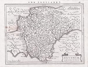
"Devoniae" - Devonshire England Great Britain Gro�britannien
Language: German
Published by Amsterdam, Janssonius, 1651
Seller: Antiquariat Steffen V�lkel GmbH, Seubersdorf, Germany
Seller rating 5 out of 5 stars
Map
Rare map which appears only in two editions of the Atlas Minor. Blatt-Ma�e: ca. 17,5 x 23 cm -- Original Kupferstich-Karte von Gerard Mercator. R�ckseitig mit deutschem Text. Aus der deutschen Ausgabe des "Atlas Minor" von 1651. - etwas fleckig, sonst gut erhalten. || Rare original copper engraved map by Gerard Mercator. With German text on verso. From the German edition of the "Atas Minor" from the year 1651. -- with some staining, otherwise in very good condition. || The Flemish engraver and cartographer Jodocus Hondius (15631612), bought Mercator's plates after his death, and published this reduced version of Mercator's folio Atlas sive Cosmographis, and added some 36 of his own maps - a pocketversion - Atlas Minor - which Hondius published together with his partners Cornelius Claesz and Johannes Janssonius. It became a large success, and was translated into several languages and issued in c. 40 editions. // Wir, das Antiquariat Steffen V�lkel, kaufen und verkaufen alte B�cher, Handschriften, Zeichnungen, Autographen, Grafiken und Fotografien. Wir sind stets am Ankauf von kompletten Bibliotheken, Sammlungen und Nachl�ssen interessiert. Sprache: Deutsch Gewicht in Gramm: 10.
-

"Fionia" - Funen island / Danmark / D�nemark / Denmark
Language: German
Published by Amsterdam, Jan Janssonius, 1651
Seller: Antiquariat Steffen V�lkel GmbH, Seubersdorf, Germany
Seller rating 5 out of 5 stars
Map
Blatt-Ma�e: ca. 17,5 x 23 cm -- Original Kupferstich-Karte von Gerard Mercator. R�ckseitig mit deutschem Text. Aus der deutschen Ausgabe des "Atlas Minor" von 1651. - gut erhalten. || Rare original copper engraved map by Gerard Mercator. With German text on verso. From the German edition of the "Atas Minor" from the year 1651. -- in very good condition. || The Flemish engraver and cartographer Jodocus Hondius (15631612), bought Mercator's plates after his death, and published this reduced version of Mercator's folio Atlas sive Cosmographis, and added some 36 of his own maps - a pocketversion - Atlas Minor - which Hondius published together with his partners Cornelius Claesz and Johannes Janssonius. It became a large success, and was translated into several languages and issued in c. 40 editions. // Wir, das Antiquariat Steffen V�lkel, kaufen und verkaufen alte B�cher, Handschriften, Zeichnungen, Autographen, Grafiken und Fotografien. Wir sind stets am Ankauf von kompletten Bibliotheken, Sammlungen und Nachl�ssen interessiert. Sprache: Deutsch Gewicht in Gramm: 550.

![Seller image for Weltkarte ad usum navigantium - 3 Teile in einem : 1. [Faltkarte] Nova et avcta orbis terrae descriptio ad vsvm na u�gant�um emendat� accommodata : Weltkarte "zum Gebrauch der Seefahrer" / 2. Begleitheft / 3. Anmerkungen zum Begleitheft, Personenregister. for sale by Antiquariat Thomas Haker GmbH & Co. KG](https://pictures.abebooks.com/inventory/md/md32275248411.jpg)
![Seller image for Germania. - [Farbiger Nachdruck einer Karte aus "Germaniae tabulae geographicae", 1594]. for sale by ANTIQUARIAT Franke BRUDDENBOOKS](https://pictures.abebooks.com/inventory/md/md32208034659.jpg)

![Seller image for [Map] The Countie of Holland for sale by Lloyd Zimmer, Books and Maps](https://pictures.abebooks.com/inventory/md/md32028455111.jpg)
![Seller image for [Map] The Dukdome of Brabant for sale by Lloyd Zimmer, Books and Maps](https://pictures.abebooks.com/inventory/md/md32028450372.jpg)
![Seller image for [Map] The Dioecese of Leden for sale by Lloyd Zimmer, Books and Maps](https://pictures.abebooks.com/inventory/md/md32028456039.jpg)
![Seller image for [Map] The Lordship of Groninga for sale by Lloyd Zimmer, Books and Maps](https://pictures.abebooks.com/inventory/md/md30218335280.jpg)