
Order Total (1 Item Items):
Shipping Destination:

Dury Andrew (23 results)
Skip to main search results
Search filters
Product Type
- All Product Types
- Books (17)
- Magazines & Periodicals (No further results match this refinement)
- Comics (No further results match this refinement)
- Sheet Music (No further results match this refinement)
- Art, Prints & Posters (No further results match this refinement)
- Photographs (No further results match this refinement)
- Maps (6)
- Manuscripts & Paper Collectibles (No further results match this refinement)
Condition Learn more
- New (2)
- As New, Fine or Near Fine (1)
- Very Good or Good (10)
- Fair or Poor (No further results match this refinement)
- As Described (10)
Binding
Collectible Attributes
- First Edition (2)
- Signed (No further results match this refinement)
- Dust Jacket (No further results match this refinement)
- Seller-Supplied Images (18)
- Not Print on Demand (22)
Language (2)
Free Shipping
- Free Shipping to U.S.A. (No further results match this refinement)
Seller Location
Seller Rating
-

Dury and Andrews 1766 Map of Hertfordshire - Digitally Redrawn Map in Six Sheets in Booklet Form with Explanatory Notes
Language: English
Published by Andrew Macnair, United Kingdom, 2013
ISBN 10: 0957447752 ISBN 13: 9780957447752
Seller: RIVERLEE BOOKS, Waltham Cross, HERTS, United Kingdom
Seller rating 5 out of 5 stars

Soft cover. Condition: New. 'A Topographical Map of Hart-Fordshire' Brand new set of 6 Maps.
-

A topographical map of Hartford-shire, from an actual survey : in which is express'd all the roads, lanes, churches, noblemen and gentlemen's-seats, and everything remarkable in the county : together with the division of the parishes
Published by Hertfordshire Publications, 1980
ISBN 10: 0901354171 ISBN 13: 9780901354174
Paperback. Condition: Very Good. 0901354171. 1986 reprint, bright clean copy, no markings, Professional booksellers since 1981.
-

A Topographical Map of Hartford-shire (1766)
Published by Hertfordshire Publications, 1980
ISBN 10: 0901354171 ISBN 13: 9780901354174
Seller: April House Books, Chipping Norton, United Kingdom
Seller rating 5 out of 5 stars
Soft cover. Condition: Very Good. Approximately A3-sized 16-page (stitched booklet) reproduction in soft covers. **PLEASE NOTE** that there may be a surcharge to pay for international postage (at cost) on this item: we'll advise you of the amount when you order, and you will have the option of accepting or cancelling at that point.
-
Half-Leather. Condition: Very Good. No Jacket. Andrew Dury (illustrator). Two volumes in one, half-leather with marbled boards. 16" x 22" . printed for and sold by A. Dury, in Duke's Court, St Martin's Lane, 1765. Sardinia map taken from the famous map of Borgonio and Genoa taken from the celebrated Spanish map of that country by Chaffrion. Title page in red and black and English/French. Two pages of an alphabetical index, two pages with remarks on the interpretation of the maps. The Sardinia maps include 12 double sheets. dedication engraving. Some outline hand coloring. The Genoa map: Eight double sheets and single dedication engraving. Some light foxng, generally clean and very strong impressions throughout. Front free end page detached but present with some edge chips. Ex-library with pencil notations to top right corner of titlt page and a small duplicate copy ink stamp on reverse of title page. Otherwise clean and unmarked throughout.Leather on corners of boards worn. Boards worn at edges with corners rounded. Spine covering missing with some remnants on boards and ends of page signatures. Signatures tight. A very nice copy in an unrestored state of a scarce title. Photos of all pages available- please inquire. Shipping will exceed the standard rate due to size.
-

Condition: New. Print on Demand pp. 90.
-
A Topographical Map of the County of Wilts. Describing the Seats of the Nobility and Gentry, Turnpike and Cross Roads, Canals, etc.
Published by William Faden, London, 1773
Seller: Clive A. Burden Ltd., Chalfont St. Giles, BUCKS, United Kingdom
Seller rating 5 out of 5 stars
Map
No binding. Folio (560 x 400 mm.), contemporary half calf, ornate blind ruled, with original red calf gilt title label affixed to upper board, rebacked. With typographic title page, index table, general index map of the county, and 18 double page sheets each approximately 460 x 630 mm., all in early outline colour, light offsetting as usual, otherwise in good condition. This is one of three large scale county surveys published by the partners John Andrews (fl.1766-98) and Andrew Dury (fl.1742-78). The other counties were of Hertfordshire published c.1766 and Kent in 1769. This, the last of their counties, was first published in 1773. All three were undertaken at the very large scale of TWO INCHES TO THE MILE, only a handful were published with this much detail in the eighteenth century. This is an example of the second edition published by William Faden, it is rarer than the first. Indeed, the general index map is known by only the one example in the Royal Geographical Society and one other example found in the Kentish Catalogue of 1997. Faden improved the map considerably with new information. A further feature is the introduction of a title page and a list of the towns, villages and 'Principal Seats of the Nobility and Gentry'. The numeration of the plates was also altered; it now starts in the north west corner of the county. He removed the old list of subscribers and replaced it with a new title. The ornate dedication cartouche to the landowners of the county was designed by Giovanni Battista Cipriani and engraved by James Caldwell (1739-1822). Provenance: private English collection. Kentish 'Large Scale County Maps of England and Wales 1705-1832', no. 63; Rodger (1972) 495; Worms & Baynton-Williams (2011).
-
[Composite Atlas of the World]
Published by Robert Sayer & Thomas Jefferys & William Faden & Andrew Dury, 1788
Seller: Barry Lawrence Ruderman, La Jolla, CA, U.S.A.
Seller rating 5 out of 5 stars
Hardcover. Condition: vg+. A Large, Handsome Faden Composite Atlas With 39 Large Maps, Including 3 Standouts.This composite atlas, a remarkable amalgamation of large-scale maps by the preeminent British cartographers of the late 18th Century, is a. Folio. Expertly rebacked and recornered in calf antique, utilizing 18th-century diced russia, over contemporary marbled paper boards. (Minor rubbing.) Contemporary manuscript table of contents, 39 engraved maps and charts by Faden, Sayer, Speer, Jefferys, and others (on 47 sheets; of which 26 folding, 20 double-page), 41 in original hand-color. (A few folds at tears, some faint offsetting.) Overall an extremely handsome atlas. A Large, Handsome Faden Composite Atlas With 39 Large Maps, Including 3 Standouts.This composite atlas, a remarkable amalgamation of large-scale maps by the preeminent British cartographers of the late 18th Century, is a testament to the era's cartographic excellence and geopolitical complexities. The atlas incorporates three of the great America-centric maps from the last quarter of the 18th century, Faden's The United States of North America, Speer's Chart of the West Indies, and the Faden-Roberts "Lost Cook Chart".William Faden's The United States of North America (1785) captures the post-Revolutionary War era, delineating the newly defined United States boundaries as established by the Treaty of Paris. Its intricate coloring distinguishes American, British, and Spanish territories, highlighting the strategic Newfoundland coasts and emphasizing French fishing rights. The map's iterative quality, updated continuously by Faden throughout its decades-long publication history, makes it one of the enduring records of the United States' early development.Joseph Smith Speer's Chart of the West Indies from 1774 provides a detailed portrayal of the Caribbean and southeastern North America at the brink of the American Revolution. Speer, a skilled hydrographer, adeptly color-coded territories under various European powers, offering insights into the geopolitical climate of the period and including crucial maritime information.Henry Roberts and William Faden's Chart of the N.W. Coast of America and the N.E. Coast of Asia, in this, its first state, is often referred to as Captain James Cook's "lost chart," which depicts the Northern Pacific Coastlines. It illustrates Cook's discoveries on his revelatory Third Voyage, as well as the territorial reaches of British, Russian, and Spanish explorations.Collectively, these maps narrate the dynamic interplay of national development, exploration, and colonial ambition, reflecting the complexities and transformations of the late 18th century.ContentsThe present atlas has seven 4-sheet maps (Africa, the Americas, Asia, the Black Sea region, Europe, and the Mediterranean). There are also ocean charts, maps of India, a Mercator-style world map that shows the route of Cook s voyages, and many others.1. William Faden. A New General Chart of the World, Exhibiting the Whole of the Discoveries made by the late Captain James Cook, F.R.S. with the Tracks of the Ships under his Command: Also those of Capn. Phipps (now Lord Mulgrave) in his Expedition to the North Pole. January 1st. 1787.2. William Faden. Western New World or Hemisphere 3d Edition. 28th. October, 1786 [on sheet with:] Old World or Eastern Hemisphere. 3d Edition. Decr. 1st. 1786.3. William Faden. Northern Hemisphere 2d Edition. Decr. 1st 1783. [on sheet with:] Southern Hemisphere. Jany. 1, 1783.4 and 5. Robert Sayer. Europe Divided into Its Empires, Kingdoms, States Republics, &ca. By Thos. Kitchin, Hydrographer to The King, with many Additions and Improvements from the latest Surveys and Observations. Jany 1st, 17876 and 7. Robert Sayer & Thomas Kitchin. South Britain or England & Wales. Drawn from several Surveys &c. Book.
-
A New General And Universal Atlas. Containing Forty Five Maps By Andrew Dury.Engraved By Mr. Kitchen & Others
Published by Printed For & Sold By Laurie & Whittle And Bowles & Carver
Seller: Roger Collicott Books, Widecombe in the Moor, DEVON, United Kingdom
Seller rating 5 out of 5 stars
First Edition
Hardcover. Condition: Very Good. 1st Edition. Circa 1770S.Highly Decorated Engraved Vignette Title-Page, Likewise The Dedication Page.Thirty-Nine Beautifully Hand Coloured Maps In Amazingly Clean Fresh Condition. Cont. Full Calf Neatly Rebacked Morocco Label. Size : 17.5 X 15.5 Cms. The Collation Seems To Match The List Of Maps, Except Only One Map Of Canada Present. Shirley ,Dtory - 1A "Their Copy Similarly Has One Map For Canada. "There Are Fewer Maps Than Noted In The Title As One Or Two Occupy More Than One Leaf." Shirley Lists The Publisher As Drury And Robert Sayer Also Lists The 1761 First Edition Carington Bowles.
-
Carte Chorographique des États du Roi de Sardaigne, en douze feuillets tirée de la fameuse carte de Borgonio, à laquelle on a fait des corrections & augmentations considérables.
Published by (Segue:) CARTE CHOROGRAPHIQUE DE LA REPUBLIQUE DE G�NES, en huit feuilles, tir�e de l'excellente carte des m�mes pays en espagnol par Chaffrion. Londres, A- Dury, 1765,, Londra, 1765
Seller: Libreria Antiquaria Pregliasco, Torino, TO, Italy
Seller rating 4 out of 5 stars

Condition: molto buono. Album in-folio (mm.530x400), legatura coeva mezza pelle e ang., dorso a nervi con titolo oro. Due parti in un vol., titolo generale in inglese e francese: I) carta d'assieme, dedica figurata al nobile John Earl of Bute, 10 carte topografiche per il Borgonio 1680, tutti incisi in rame su doppia pagina. II) Doppio foglio a stampa di spiegazioni e istruzioni; una carta generale degli Stati della Repubblica di Genova; 8 carte su doppia pagina dell'atlante di Chaffrion del 1685(una con la Sardegna e la Corsica). Confini dipinti. Magnifico atlante che migliora le conoscenze cartografiche del Borgonio e dello Chaffrion su Piemonte e zone alpine, particolarmente del Monte Bianco e della Liguria, Esemplare completo, perfettamente conservato. Cfr. Aliprandi, Cartografia Alpina, 49/1, 50, e 50/1, 50/2. Book.
-

A New, General, And Universal, Atlas
Published by London: Printed for & Sold by A.DuryRobert Sayer& Carrington Bowles, [c1763]., 1763
Seller: D & E LAKE LTD. (ABAC/ILAB), Toronto, ON, Canada
Seller rating 2 out of 5 stars

Hardcover. Condition: Good. oblong 8vo. engraved title, engraved dedication, engraved list of maps, & 39 hand-coloured maps on 45 plates (6 folded), engraved by Thomas Kitchen & others. contemporary calf (very worn & oxidized but sound, joints repaired, light offsetting & short tears to folds of a few maps - no loss). armorial bookplate of Jones Tirel-Morin. Second Edition (?). The maps in this edition of Dury's atlas have an additional title above the upper margin. Three, those of North America, Canada and the West Indies, have been revised to incorporate the results of the 1763 Treaty of Paris that put an end to the Seven Years' War and France's position as a major colonial power in North America. Phillips, Atlases, 634.
-
A New, General and Universal Atlas
Published by Dury and Sayer (London), 1761
Seller: Libreria Antonio Pettini, ROMA, RM, Italy
Seller rating 5 out of 5 stars
First Edition
Rilegato. Condition: ottimo. prima edizione. In-8� oblungo, contiene: frontespizio inciso su rame+dedica (Benoist del. et sculp.)+l'indice delle mappe+39 carte (numerate 1 a 45), tutte con coloriture originali, incluse 6 ripiegate (ciascuna � numerata come 2 carte) . Rara edizione originale di questo graziosissimo atlante portatile. Tra le carte: il planisfero, l'India, l'Africa, il Senegal, l'America del Nord, l'America del Sud, il Canada, l'Irlanda, la Scozia, il nord dell'Inghilterra, e il sud, carte dettagliate dell'Europa, la Russia, la Turchia. Legatura coeva in pelle, con tassello al dorso.
-
![Seller image for [No title]. for sale by Tooley, Adams & Co.](https://pictures.abebooks.com/inventory/md/md31767867869.jpg)
[No title].
Published by London, 1764. 120 x 95mm (4� x 3� inches)., 1764
Seller: Tooley, Adams & Co., Wallingford, OXON, United Kingdom
Seller rating 3 out of 5 stars

Original colour; light soiling mainly to margins, otherwise fine condition. A miniature map of Connaught. Published by Dury in 'A Collection of Plans of the Principal Cities of Great Britain and Ireland: with Maps of the Coast of the said Kingdoms;'. Possibly engraved by J Cheevers.
-
![Seller image for [No title]. for sale by Tooley, Adams & Co.](https://pictures.abebooks.com/inventory/md/md31767873319.jpg)
[No title].
Published by London, 1764. 120 x 95mm (4� x 3� inches)., 1764
Seller: Tooley, Adams & Co., Wallingford, OXON, United Kingdom
Seller rating 3 out of 5 stars
Original colour; light soiling mainly to margins, otherwise fine condition. A miniature map of Ulster. Published by Dury in 'A Collection of Plans of the Principal Cities of Great Britain and Ireland: with Maps of the Coast of the said Kingdoms;'. Possibly engraved by J Cheevers.
-
![Seller image for [No title]. for sale by Tooley, Adams & Co.](https://pictures.abebooks.com/inventory/md/md31767874243.jpg)
[No title].
Published by London, 1764. 120 x 95mm (4� x 3� inches)., 1764
Seller: Tooley, Adams & Co., Wallingford, OXON, United Kingdom
Seller rating 3 out of 5 stars
Original colour; light soiling mainly to margins, otherwise fine condition. A miniature map of Leinster. Published by Dury in 'A Collection of Plans of the Principal Cities of Great Britain and Ireland: with Maps of the Coast of the said Kingdoms;'. Possibly engraved by J Cheevers.
-
A Topographical Hand Coloured Map of the County of Kent in 25 Sheets: Sheet Covering Ickham to the West, Pegwell, Greystone Bay, Deal and Walmer to the East, Stourmouth and Ebsfleet to the North, Kingsdown and Eythorne to the South
Published by Printed by Drury and Andrews, London . London 1769., 1769
Seller: Little Stour Books PBFA Member, Canterbury, United Kingdom
Association Member: PBFA
Seller rating 5 out of 5 stars
Condition: Very Good. Original hand coloured map mounted on linen measuring 27�'' x 18''. Super boats out at sea also showing 'Brake' and 'Crofs Ledge' [Goodwin Sands]. Just a little fraying to the edges, colours sharp and bright, without any creases and in Very Good clean condition. Member of the P.B.F.A. KENT [Stourmouth].
-
A Chorographical Map of the King of Sardinia's Dominions. On Twelve Sheets. Taken from the famous Map of Borgonio. With many Additions and Improvements . A Chorographical Map of the Territories of the Republic of Genoa. On Eight Sheets. Taken from the celebrated Spanish Map of that Country by Chaffrion
Published by Printed for and Sold by A. Dury, London, 1765
Seller: James Cummins Bookseller, ABAA, New York, NY, U.S.A.
Seller rating 5 out of 5 stars
Letterpress title printed in red and black in English and French. 11 double-page mapsheets hand colored in outline, 2-leaf letterpress table [i.e. the 12th sheet of the map, numbered so at the upper right corner], 2-leaf Remarques in French, double-page index map of Republic of Genoa hand colored in outline, 8 double-page mapsheets hand colored in outline. Lacks the index map of Sardinia. Folio (20-1/2x15 inches). Dury's edition of Giovanni Tommaso Borgonio's Carta corografica degli Stati di S.M. il Re di Sardegna (on 25 sheets, published 1683) and Jos� Chaffrion's Carta dela rivera de Genoa (12 sheets, 1685), comprising wall maps of Sardinia and Genoa bound in sheets as an atlas. ESTC N66751 (locating 2 copies) Nineteenth century half calf and pastepaper boards, worn. Maps toned. Provenance: General Theological Seminary (inked stamp on title, bookplates) Letterpress title printed in red and black in English and French. 11 double-page mapsheets hand colored in outline, 2-leaf letterpress table [i.e. the 12th sheet of the map, numbered so at the upper right corner], 2-leaf Remarques in French, double-page index map of Republic of Genoa hand colored in outline, 8 double-page mapsheets hand colored in outline. Lacks the index map of Sardinia. Folio (20-1/2x15 inches).
-

A Topographical Map of the County of Wilts. Describing the Seats of the Nobility and Gentry, Turnpike and Cross Roads, Canals, etc.
Published by William Faden, London, 1773
Seller: Clive A. Burden Ltd., Chalfont St. Giles, BUCKS, United Kingdom
Seller rating 5 out of 5 stars
Map
No binding. Condition: Very Good. A VERY LARGE TWO INCH TO THE MILE MAP. Eighteen double-page sheets each approximately 465 x 645 mm., all in early outline colour, most internal edges trimmed to neatline with no loss of any imprint, a couple of minor tears repaired, extreme lower right corner a little waterstained, otherwise in good condition. This is one of three large scale county surveys published by the partners John Andrews (fl.1766-98) and Andrew Dury (fl.1742-78). The other counties were of Hertfordshire published c.1766 and Kent in 1769. This, the last of their counties, was first published in 1773. All three were undertaken at the very large scale of TWO INCHES TO THE MILE, only a handful were published with this much detail in the eighteenth century. This is an example of the second edition published by William Faden, it is rarer than the first. Faden improved the map considerably with new information. The numeration of the plates was also altered; it now starts in the north west corner of the county. He removed the old list of subscribers in the upper right corner and replaced it with a new title. The ornate dedication cartouche to the landowners of the county was designed by Giovanni Battista Cipriani and engraved by James Caldwell (1739-1822). Provenance: private English collection. Chubb (1911) p. 263; Kentish 'Large Scale County Maps of England and Wales 1705-1832', no. 63; Rodger (1972) 495; Worms & Baynton-Williams (2011).
-

CARTA DEGLI STATI DI S.M. IL RE DI SARDEGNA CONTENENTE IL PIEMONTE, LA SAVOIA, eamp; C. PRESA DALLA CARTA ORIGINALE DEL CELEBRE BORGONIO CON MOLTE AGGIUNTE E MIGLIORAMENTI DI ANDREA DURY, 1765
Published by St. Martin - A. Dury, Londra, 1765
Seller: Il Cartiglio di Roberto Cena srlu, TORINO, TO, Italy
Seller rating 5 out of 5 stars
Grandiosa carta geografica e corografica del Piemonte ispirata alla celeberrima carta di Tommaso Borgonio pubblicata nel 1680 con l`aggiunta di qualche territorio. La grande mappa in esame, in prima edizione a cui ne segu� un`altra nel 1783, fu pubblicata in atlante. Qui � presente a fogli sciolti (i primi 10 suddivisi in 8 stacchi ciascuno incollato su tela d`epoca) e raffigurano l`intera parte cartografica. Non � presente il quadro sinottico e descrittivo d`insieme, che doveva essere posizionato in alto a destra e in luogo dell`angolo inferiore sinistro abbiamo la prersenza del paesaggio montano sempre pubblicato nell`atlante qui in formato ridotto,rifilata ai margini. Carta incisa su matrici di rame e colorata all`acquarello d`epoca lungo i confini. Esemplare in eccellenti condizioni.
-
Il portafoglio necessario a tutti quelli che fanno il giro d Italia, nel quale si trova un esatta descrizione delle Citt�, Borghi, ville e fiumi; la spiegazione delle pi� belle vedute che occorrono per la strada, s� a destra che a sinistra in ventisei carte topografiche.
Published by printed for A. Dury, London, 1774
Seller: Libreria Ex Libris ALAI-ILAB/LILA member, Roma, RM, Italy
Seller rating 5 out of 5 stars
Elegante legatura inglese in marocchino rosso con piccoli nervi, ricchi fregi e titolo ( Roads of italy ) oro su tassello al ds. Cornici ai piatti con fleurons angolari. Labbri e dentelles decorate. Carte di guardia marmorizzate. Lievi tracce d usura al dorso e agli angoli. Tavola n. 9 con minime imperfezioni marginali, peraltro esemplare in ottimo stato di conservazione. Guida assai rara - censita da ICCU in due sole biblioteche italiane - alle stazioni postali lungo i principali itinerari, raffigurate nel dettaglio insieme a fiumi, citt� e coste presenti lungo il percorso. In particolare, le indicazioni riguardanti osterie e alberghi sono estremamente curiose, talvolta accompagnate da onesti giudizi sulla loro qualit�. 8vo (cm. 19,5), 36 pp. Con una Carta generale delle Poste d Italia e 26 tavole itinerarie ripiegate in bella coloritura d epoca). Frontespizio e testo paralleli in italiano e francese.
-
A Topographical Map of the Republick of Genoua, Taken from the Celebrated Map by Chaffrion1764 / To the Right Honourable James Steward Mackenzie, Lord Privy Seal of Scotland, One of His Majesty s most Honourable Privy Council, and Late His Majesty s Envoy Extraordinary and Plenipoteniary to the King Of Sardina. This Map is most Humbly Inscribed
Published by London, 1764
Seller: Neatline Antique Maps, Tiburon, CA, U.S.A.
Seller rating 4 out of 5 stars
Map
No Binding. Condition: Very Good. A spectacular and historically important 18th century wall-map of the Republic of Genoa. Details In many ways, this beautifully composed chart of the Republic of Genoa epitomizes why we love maps. It is deeply evocative, not only of a time in which Italy remained segregated into republics and principalities, but indeed of the dramatic landscapes of the French and Italian Rivieras that once constituted the Republic of Genoa. It is thus that each time we engage with this map, different details seem to jump off the page. Sometimes the first thing that comes to mind is the natural topography: the way the mountains of Liguria press right up to the sea, giving shape to the dramatic and picturesque port towns of Portofino, Sanremo, and Monaco, and the fashionable beach towns of Antibes, Nice, and Cannes. Other times, this is a map that makes us think about power both gained and lost for at the center of the map we find the heart of the Republic: the great city of Genoa. The Republic of Genoa was a dominant maritime power and far-reaching mini-empire that existed for almost seven centuries. And yet, the end was near, and before the turn of the century, Napoleon would erase it from the map. In that sense, this map constitutes an historically important documentation of a key region in Europe on the cusp of change. Neatline is famous for its detailed and in-depth descriptions. To receive the full description for this listing free of charge, please contact us using the 'ask the seller' function below.
-
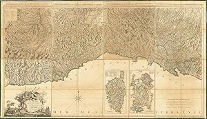
A Chorographical Map of the King of Sardinia's Dominions. [BOUND WITH] A Chorographical Map of the Territories of the Republic of Genoa.
Published by London printed for and sold by A. Dury, 1765
Seller: Shapero Rare Books, London, United Kingdom
Association Member: ABA ILAB PBFA
Seller rating 5 out of 5 stars
Map
Folio (54.9 x 37.5cm). General title-page in English and French and printed in red and black, 2-page index, 2-page explanations, 11 (of 12) douple-page map-sheets incl. index map, double-page index map and 8 map-sheets, all maps hand-coloured in outline, 2 leaves of text and 2 index leaves in French, printed on rectos only; without the double-page engraved dedication, title a bit browned and spotted, first map of the republic of Genoa lightly stained, a few maps very lightly browned. Contemporary half russia; extremities lightly rubbed, corners bumped. mba004 A fine example, with aristocratic provenance, of Dury's London edition of two wall-maps of North-Western Italy: Borgonio's Carta corografica degli Stati di S.M. il Re di Sardegna and Chaffrion's Carta dela rivera de Genoa. Giovanni Tomasso Borgonio (1620-83) was a Piedmontese military engineer active in the Kingdom of Savoy in the late 1770s and early 1680s, who made a series of important surveys of towns of the region, many published in Blaeu's Town Books of Italy (the Savoy (Sabaudia) volumes, Amsterdam 1682). He is however best known for his remarkable survey of the Kingdom of Sardinia, published as Carta generale de' Stati di S.A.R. in 1680. Jos� Chaffrion (1653-98), a Spanish military engineer, was active in Piedmont in the 1680s, producing a fine map of Liguria in 1685. Both are outstanding examples of the surveyors' art, both are very rare in the original printing and both had a huge (and long-term) influence on the cartography of the two regions, neither map really superseded for over a century. When Andrew Dury (d. 1777), a London publisher of French Huguenot extraction, decided to issue maps of these two regions, these were still the best maps available to him - and this London edition catches in full the quality and detail of the originals. The Borgonio map was dedicated to John, Earl of Bute, some-time favourite of and Prime Minister to King George III; however, he enjoyed a spectacular fall from grace when he lost the ear of the king, and the absence, in this copy, of the sheet bearing the dedication to him (which has no map content) may reflect the politics of the day, as there is no evidence of its later removal. Cox II, p.406; Shirley BL T.DURY-3a.
-

A Topographical Map of Hertfordshire from an Actual Survey; in which is Expressed all the roads, lanes, churches, noblemen, and gentlemen's - seats, and every thing remarkable in the County: together with the divisions of the parishes. By Andw. Dury, Jno. Andrews.
Published by William Faden Charing Cross, 1st January, 1782., London,, 1782
Seller: Daniel Crouch Rare Books Ltd, London, United Kingdom
Association Member: ABA ILAB PBFA
Seller rating 4 out of 5 stars
Map
Hertfordshire - Rare large-scale map of Hertfordshire Folio (550 by 400mm), index map, large-scale engraved map, on nine sheets, fine original full-wash colour, plan of Hertford, and plan of St Albans, half-calf over blue marbled paper boards. Andrews's and Dury's large scale map of Hertfordshire. John Andrews and Andrew Dury were responsible for three large scale eighteenth century county surveys: the present map - Hertfordshire 1766 , Kent 1769, and Wiltshire in 1773. All three surveys are on a scale of two inches to one mile. The majority of the large scale maps were on a scale of one inch to one mile. This larger scale allowed for much greater detail; and the map depicts hills, woods and barrows, commons heaths and parks, rivers, ponds and wells, bridges and windmills, churches and chapels, towns, villages and parishes, gentlemen's seats, farms and houses, turnpikes, secondary roads and lanes, county and hundred boundaries. A note on the map reads "NB The Western Part of this County from Chipping Barnet along the North Road was Survey'd by John Andrews, the East Part by Andrew Dury etc". Dury was a London book-seller who probably put up most of the capital for the project. The map, which sold for �1.16s. in sheets, is functional rather than decorative, the title being contained in a simple rectangle. The only decoration is provided by the dedication - a large vignette engraving incorporating a hunting scene with the names of various nobility on a banner in the sky. Although the name of the map's engraves is not given, it could be possibly have been John Cheevers who engraved the town plans that were published by Dury around the same time.
-

A Plan of the City and Castle of Chester.
Publication Date: 1764
Seller: Altea Antique Maps, London, United Kingdom
Association Member: ABA ILAB PBFA
Seller rating 5 out of 5 stars
Map
London: Dury, 1764. Fine original colour. 115 x 140mm. A good example. A charming miniature, one of the few 18th century plans of Chester, with an eight-point key. It was published in Dury's rare pocket atlas, 'A Collection of Plans of the Principal Cities of Great Britain & Ireland, with Maps of the Coast of the Said Kingdoms, Drawn from the most Accurate Surveys, In Particular those taken by the late Mr. J. Rocque, Topographer to His Majesty'. This was designed as a companion to Dury's 'Universal Pocket Atlas'.


![Seller image for [Composite Atlas of the World] for sale by Barry Lawrence Ruderman](https://pictures.abebooks.com/inventory/md/md31731206329.jpg)


![Seller image for A Chorographical Map of the King of Sardinia's Dominions. [BOUND WITH] A Chorographical Map of the Territories of the Republic of Genoa. for sale by Shapero Rare Books](https://pictures.abebooks.com/inventory/md/md30606553099.jpg)