
Order Total (1 Item Items):
Shipping Destination:

Dix Thomas Illustrated (1 results)
Skip to main search results
Search filters
Product Type
- All Product Types
- Books (No further results match this refinement)
- Magazines & Periodicals (No further results match this refinement)
- Comics (No further results match this refinement)
- Sheet Music (No further results match this refinement)
- Art, Prints & Posters (No further results match this refinement)
- Photographs (No further results match this refinement)
- Maps (1)
- Manuscripts & Paper Collectibles (No further results match this refinement)
Condition Learn more
- New (No further results match this refinement)
- As New, Fine or Near Fine (No further results match this refinement)
- Very Good or Good (No further results match this refinement)
- Fair or Poor (No further results match this refinement)
- As Described (1)
Binding
- All Bindings
- Hardcover (No further results match this refinement)
- Softcover (No further results match this refinement)
Collectible Attributes
- First Edition (1)
- Signed (No further results match this refinement)
- Dust Jacket (No further results match this refinement)
- Seller-Supplied Images (1)
- Not Print on Demand (1)
Language (1)
Price
- Any Price
- Under � 20 (No further results match this refinement)
- � 20 to � 40 (No further results match this refinement)
- Over � 40
Free Shipping
- Free Shipping to U.S.A. (No further results match this refinement)
Seller Location
Seller Rating
-
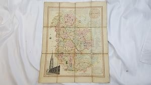
A New Map of the County of Lincoln, Divided into Wapentakes Etc. giving Market Towns and Market Days
Published by Published by William Darton, London, 1820
Seller: Keoghs Books, Skipton, United Kingdom
Association Member: PBFA
Seller rating 5 out of 5 stars

Map First Edition
, 16 x 19.5 inch linen backed colour map ( approximately 5.25 miles to the inch), giving local information in text and illustrated with an engraving of Louth Steeple in the lower left hand corner First Edition , some wear to linen at folds, especially at corners where the linen is worn through without affecting the map, some sections of the map show slight wear at corners, slight foxing, colour bright and in good condition 16 x 19.5 inches linen backed map ISBN: