
Order Total (1 Item Items):
Shipping Destination:

Cornelius Danckerts (16 results)
Skip to main search results
Search filters
Product Type
- All Product Types
- Books (10)
- Magazines & Periodicals (No further results match this refinement)
- Comics (No further results match this refinement)
- Sheet Music (No further results match this refinement)
- Art, Prints & Posters (4)
- Photographs (No further results match this refinement)
- Maps (2)
- Manuscripts & Paper Collectibles (No further results match this refinement)
Condition Learn more
- New (No further results match this refinement)
- As New, Fine or Near Fine (No further results match this refinement)
- Very Good or Good (2)
- Fair or Poor (No further results match this refinement)
- As Described (14)
Binding
- All Bindings
- Hardcover (1)
- Softcover (No further results match this refinement)
Collectible Attributes
Language (2)
Free Shipping
- Free Shipping to U.S.A. (No further results match this refinement)
Seller Location
Seller Rating
-

Condition: Good. Inclusief bijhorende kaart.
-
D'Voornamste Fortresse aen de River den Rhyn. Uytgegeven door Cornelis Danckerts Met Prieveleeie.
Published by Amsterdam ca, 1696
Seller: Neusser Buch & Kunst Antiquariat, Neuss, NRW, Germany
Seller rating 5 out of 5 stars

Art / Print / Poster
Kupferstich, altkoloriert,Fl�chenkolorit, Darstellung: 47 x 57,5 Blatt: 52 x 60. Papier durchgehend etwas gebr�unt, Blattr�nder etwas stockfleckig und fingerfleckig, im Ganzen gut erhalten. Auf Wunsch Digitalaufnahme in jpg-Format erh�ltlich- photo in jpg-format available. Je nach Versandart k�nnen die Portokosten bis zu 2 weniger als angegeben betragen. Besfestigungspl�ne von 20 (Rhein)st�dten: Schenkenschanz, Rees, Emmerich, Wesel, L�ttich, Aachen, J�lich, Rheinberg, K�ln, Bonn, Mainz, Koblenz, Landau, Philippsburg, Mannheim, Fort Luois, Stra�burg, Breisach, H�ningen, Basel. Sprache: Deutschu.
-
D'Voornaamste fortresse van Koningryck Napels en Sisielie, in Italie
Published by Amsterdam, 1680
Seller: libreria antiquaria perini Sas di Perini, Verona, VR, Italy
Seller rating 5 out of 5 stars
Art / Print / Poster
Incisione in rame, colorata d'epoca, mm 450x600. Non comune foglio raffigurante le cinte murarie delle maggiori citt? del centro-sud Italia. La famiglia Danckerts, tre generazioni di stampatori e cartografi, fu tra le pi? attive per circa un secolo e nella seconda parte del secolo produsse numerosi atlanti. Splendido esemplare a pieni margini.
-
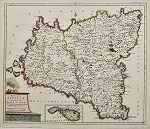
Regni Siciliae et insulae Maltae et Gozae
Published by Amsterdam, 1680
Seller: libreria antiquaria perini Sas di Perini, Verona, VR, Italy
Seller rating 5 out of 5 stars
Art / Print / Poster
Incisione in rame, colorata d'epoca ai confini e ad alcuni dettagli, mm 485x575. Rara e bella carta della Sicilia e isole limitrofe. La famiglia Danckerts, tre generazioni di stampatori e cartografi, fu tra le pi? attive per circa un secolo e nella seconda parte del Seicento produsse numerosi atlanti. Ottimo esemplare con lievi e piccoli aloni marginali. Nr.cat: P6160134.
-
Insulae Americanae Nempe: Cuba. Hispaniola. Jamaica. Pto. Rico. Lucana. Antillae vulgo Caribae. Barlo-Et Sotto-Vemto, Etc. (Central America/Caribbean)
Published by Amsterdam, 1685
Seller: Arader Galleries of Philadelphia, PA, Philadelphia, PA, U.S.A.
Seller rating 4 out of 5 stars

N/A. Condition: Very Good. Dust Jacket Condition: N/A. Engraving with original line hand-color. Sheet size: 20 1/2 x 24 1/2". Inventory#: p1385pmat.
-

Dominii Veneti in Italia in partes accurate divisae ac Statuum Ducum Mantuae et Mirandolae Parmae, Mutinae, novissima descriptio.
Published by Amsterdam,, 1680
Seller: libreria antiquaria perini Sas di Perini, Verona, VR, Italy
Seller rating 5 out of 5 stars
Art / Print / Poster
Incisione in rame, coloritura d'epoca, mm 500x605.Bell'esemplare in coloritura coeva e piega centrale editoriale. Sanfelici-Zanasi-Davoli "Terre di Langobardia. La Lombardia, il corso del Po.", 24. Nr.cat: P5250209.
-

Stoel Des Oorlogs in America waar in Vertoont Werden alle Desself Voornaamste Eylande
Published by Antwerp, 1680
Seller: Alexandre Antique Prints, Maps & Books, Toronto, ON, Canada
Seller rating 4 out of 5 stars
Map
Size : 490x575 (mm), 19.25x22.625 (Inches), Original Hand Coloring Very Good, lower margin is shaved closely.
-

Landgraviatus Hassiae Darmstadiensis Rhenofeldensis cum adjacentibus Regionibus ut Landgraviatuum Thuringiae Ducatuum Westfaliae Brunwicensis Comitatuum Hanoviae Nassoviae cum Abatia Vuldense ect: Accuratissima Discriptio edita Per Theodorum Danckerts Amstelod: cum Privil: Ordinum Holl: et Westfrisiae. Gro�e Landkarte der Landgrafschaft Hessen vom Erzbistum Paderborn und dem Herzogtum Braunschweig im Norden bis Rheinland-Pfalz und Darmstadt im S�den. Mit pr�chtiger Kartusche mit Weingott Bacchus, Putti, Diana mit Hunden auf der Jagd, deutschem und franz�sischem Meilenzeiger und Druckerprivileg. Original-Kupferstich von Theodor Danckerts 1696 in pr�chtiger Altkoloratur
Language: Latin
Published by Amsterdam: Offizin der Familie Danckerts mit Privileg der Staaten von Holland und Westfriesland, 1696
Seller: historicArt Antiquariat & Kunsthandlung, Wiesbaden-Breckenheim, Germany
Seller rating 5 out of 5 stars
Map First Edition Signed
1. Original-Kupferstich von Theodor Danckerts (in der Platte signiert) auf Imperialfolio-B�ttenblatt mit dekorativ abgesetztem Plattenrand, von Alter Hand sehr gewissenhaft und in pr�chtigen Farben koloriert, bildliche Darstellung ca. 49,5 x 56 cm, im breiten Blattrand au�erhalb der bildlichen Darstellung kleine Einrisse, ansonsten sauber und bemerkenswert gut erhalten, sehr selten - Diese ber�hmte Landkarte von Theodor Danckerts gilt als die sch�nste Karte Hessens, die je gestochen worden ist. - gro�er und/oder schwerer Artikel mit zus�tzlichen Kosten f�r Versand und Versicherung, muss in stabiler Papprolle verschickt werden - heavy and/or oversized item with additional costs for shipping and insurance - please ask us before you order this article 2100 gr.
-
![Seller image for Accuratissima Rheni Superioris Mosae et Mosellae Tabula [Moselle] for sale by Art Source International Inc.](https://pictures.abebooks.com/inventory/md/md30493339107.jpg)
Accuratissima Rheni Superioris Mosae et Mosellae Tabula [Moselle]
Publication Date: 1700
Seller: Art Source International Inc., Boulder, CO, U.S.A.
Seller rating 5 out of 5 stars
Stunning map of Switzerland, Baden-Wurttemberg, Alsace and Lorraine by Danckerts. Fine engraving with original outline color. This map measures 22.75 inches by 19.5 inches.
-
![Seller image for Ducatus Geldria et Zutphania Comitatus [Netherlands] for sale by Art Source International Inc.](https://pictures.abebooks.com/inventory/md/md30493340009.jpg)
Ducatus Geldria et Zutphania Comitatus [Netherlands]
Publication Date: 1700
Seller: Art Source International Inc., Boulder, CO, U.S.A.
Seller rating 5 out of 5 stars
A handsome map of Gelderland and Zutphen(Netherlands) with fine detail, oriented with north to the right. It illustrates the network of roads between all of the fortified cities and villages and the extensive dyke and canal networks. The cartouche rests atop the scale of miles, and it is topped with an armorial crest and surrounded by putti gathering the riches of the harvest. This map measures 21.5 inches by 18 inches.
-
![Seller image for Accuratissima Rheni Inferioris Mosae et Mosellea Tabula [Germany] for sale by Art Source International Inc.](https://pictures.abebooks.com/inventory/md/md30493332793.jpg)
Accuratissima Rheni Inferioris Mosae et Mosellea Tabula [Germany]
Publication Date: 1700
Seller: Art Source International Inc., Boulder, CO, U.S.A.
Seller rating 5 out of 5 stars
We are proud to offer this very hard to find map of the rivers Rhine, Maas and Waal. The map Include Belgium, Luxemburg and large part of Germany.Danckerts map are some of the finest produced in the late 17th and earth 18th centuries. This map measures 23 inches by 19.75 inches.
-
![Seller image for Le Theatre de la Guerre dans les Sevennes . [Montpellier, France] for sale by Art Source International Inc.](https://pictures.abebooks.com/inventory/md/md30493335719.jpg)
Le Theatre de la Guerre dans les Sevennes . [Montpellier, France]
Publication Date: 1700
Seller: Art Source International Inc., Boulder, CO, U.S.A.
Seller rating 5 out of 5 stars
Stunning and rare map of the South of France showing the Mediterranean port of Agde on the west to mouth of the Rhone River on the east. Beauzac is show far North. This map measures 19.5 inches by 23 inches.
-
![Seller image for Nova et Accurata Normandiae Ducatus Tabula [Rouen] for sale by Art Source International Inc.](https://pictures.abebooks.com/inventory/md/md30493333758.jpg)
Nova et Accurata Normandiae Ducatus Tabula [Rouen]
Publication Date: 1710
Seller: Art Source International Inc., Boulder, CO, U.S.A.
Seller rating 5 out of 5 stars
Another wonderfully engraved and original hand-colored map by Dankerts. This map shows the area from St Michel on the west to Dunkirk on the east. The Isle of Wight is shown in Southern England. A very rare map that has not been offered in many years. This map measures 22.25 inches by 19.5 inches.
-
![Seller image for Novissima et Accuratissima XVII Provinciarum.[Low Countries] for sale by Art Source International Inc.](https://pictures.abebooks.com/inventory/md/md30493339106.jpg)
Novissima et Accuratissima XVII Provinciarum.[Low Countries]
Publication Date: 1700
Seller: Art Source International Inc., Boulder, CO, U.S.A.
Seller rating 5 out of 5 stars
Elaborately and beautifully decorated map of the XVII Provinces of Netherlands and Belgium with the west on top. Decorative cartouche topped with a rampant lion with a sword. At the bottom of the cartouche there is the crest of Johan Munter. Munster was a wealthy merchant in Amsterdam whom held several posts of honour in Amsterdam. He became commissioner of the exchange bank, he was 'Schepen' [city councillor], was a member of the governing body of the V.O.C. and finally became major of the city. This map measures 22 inches by 18.75 inches.
-
![Seller image for Totius Africae Accuratissima Tabula . . . [Africa] for sale by Art Source International Inc.](https://pictures.abebooks.com/inventory/md/md30493333759.jpg)
Totius Africae Accuratissima Tabula . . . [Africa]
Publication Date: 1690
Seller: Art Source International Inc., Boulder, CO, U.S.A.
Seller rating 5 out of 5 stars
Gorgeous old color example of this scarce decorative map of Africa. The map became the standard for subsequent maps of Africa, originally based upon the work of Frederick De Wit. There are a number of notable deep inlets on the southeast coast. The large lakes and numerous rivers are also of note. The origin of the Nile is based upon Ptolemy. The kingdom of Monomotapa comes down a far as the Rio de Infante. There are few names in the interior of the Cape. Decorative title cartouche and a number of animal vignettes within the map. This map measures 22 inches by 19 inches.
-
![Seller image for Ducatus Britanniae Tabula cum Omnibus suis Provinciis Nova Descriptio. [Brittany,France] for sale by Art Source International Inc.](https://pictures.abebooks.com/inventory/md/md30493332794.jpg)
Ducatus Britanniae Tabula cum Omnibus suis Provinciis Nova Descriptio. [Brittany,France]
Publication Date: 1680
Seller: Art Source International Inc., Boulder, CO, U.S.A.
Seller rating 5 out of 5 stars
Quite a rare map by Dankerts of Brittany from Noirmoutier-en-Llle on the South to Normandy on the North. We were not able to find any recent sales of this map. This map measures 22.5 inches by 19.5 inches.
