Chiquet Jacques (16 results)

- Softcover
- Print on Demand
Seller: Majestic Books, Hounslow, , United KingdomMajestic Books
Contact seller4-star sellerCondition: New
£ 18.91
£ 6.50 shippingShips from United Kingdom to U.S.A.Quantity: 4 available
Condition: New. Print on Demand pp. 58.

Published by Chez Chéreau au grand St Rémy, Paris 1719
- Hardcover
Seller: Studio Bibliografico Orfeo (ALAI - ILAB), Bologna, BO, ItalyStudio Bibliografico Orfeo (ALAI - ILAB)
Contact seller4-star sellerCondition: Used
£ 1,609.17
£ 56.42 shippingShips from Italy to U.S.A.Quantity: 1 available
28x23 cm, rilegatura in mezza pelle, titolo in oro su tassello al dorso, tagli colorati; carte. 56, (4) Frontespizio con titolo in cornice animata allegorica; 26 tavole geografiche di cui 23 con i confini a colori; 26 carte di testo incorniciato. In fine 4 carte non numerate: " Geographie sacree ancienne et moderne contenant tou…s les archevechez.". Piccola mancanza al dorso e qualche carta con lievi bruniture. Senza data nel testo, ma 1719. MANCA tavola 3: "division du globe correspondance du terrestre." e carta del relativo testo,"Explication des zones". La carta 2 risulta mancante in tutti gli esemplari, che così sono recensiti nelle bibliografie Molto buono.
Published by Paris: chez Chereanau, [maps dated 1719]. 1719
- Hardcover
Seller: Arader Galleries - AraderNYC, New York, NY, U.S.A.Arader Galleries - AraderNYC
Contact seller5-star sellerCondition: Used - Very good
£ 1,248.36
Free ShippingShips within U.S.A.Quantity: 1 available
Hardcover. Condition: Very Good. Oblong 4to., (8 4/8 x 11 inches). Engraved title-page and 26 engraved maps and astronomical plates, the maps hand-coloured in outline (browned, thumbed, and with a water stain affecting six maps at the end). 19th-century half vellum, marbled paper boards (endpapers renewed). The maps related to A…merica include the world map, "L'Amerique Septentrionale", and "L'Amerique Meridionale". In 1719 Europe was in the grip of the War of the Quadruple Alliance (1718-1720) . A result of the ambitions of King Philip V of Spain, his wife, Elisabeth Farnese, and his chief minister Giulio Alberoni to retake territories in Italy and to claim the French throne, it saw the defeat of Spain by an alliance of Britain, France, Austria (then a State of the Holy Roman Empire), and the Dutch Republic. Savoy later joined the coalition as the fifth ally. Although fighting began as early as 1717, war was not formally declared until December 1718. It was brought to an end by the Treaty of The Hague.
Published by Paris 1719
- Map
Seller: Alexandre Antique Prints, Maps & Books, Toronto, ON, CanadaAlexandre Antique Prints, Maps & Books
Contact seller4-star sellerCondition: Used - Very good
£ 117.03
£ 4.54 shippingShips from Canada to U.S.A.Quantity: 1 available
Condition: Very Good. An interesting map showing the solar system according to the Copernican and Ptolemaic systems. Jacques Chiquet (1673-1721) a French cartographer only published two works. His most famous was a small atlas, called Le Nouveau et Curieux Atlas Geographique et Historiquepublished in 1719. This atlas was likely…made for the entertainment of royalty. Also in 1719, he published an atlas of France called Noveau Atlas Francais. His works are quite rare as he died shortly after they were published., Size : 165x214 (mm), 6.50x8.43 (Inches), Hand Colored.
Published by Paris 1719
- Map
Seller: Alexandre Antique Prints, Maps & Books, Toronto, ON, CanadaAlexandre Antique Prints, Maps & Books
Contact seller4-star sellerCondition: Used - Very good
£ 117.03
£ 4.54 shippingShips from Canada to U.S.A.Quantity: 1 available
Condition: Very Good. An interesting original engraving of a celestial and terrestrial globe.Jacques Chiquet (1673-1721) a French cartographer only published two works. His most famous was a small atlas, called Le Nouveau et Curieux Atlas Geographique et Historiquepublished in 1719. This atlas was likely made for the entertainme…nt of royalty. Also in 1719, he published an atlas of France called Noveau Atlas Francais. His works are quite rare as he died shortly after they were published., Size : 165x220 (mm), 6.50x8.66 (Inches), Hand Colored.
 More images
Published by c. 1750 1750
Seller: Pictura Prints, Art & Books, Overasselt, , NetherlandsPictura Prints, Art & Books
Contact seller5-star sellerCondition: Used
£ 107.28
£ 17.36 shippingShips from Netherlands to U.S.A.Quantity: 1 available
'L'AFRIQUE DRESSEE SUIVANT LES AUTEURS LES PLUS NOUVEAU.'Original antique map of Africa and parts of Arabia. Title cartouche bottom left; above the cartouche a compass rose; scale stick top left.Made by Jacques Chiquet after de Leth.Medium: Engraving / etching with outline hand colouring on hand laid (verge) paper.Sheet size: 25….7 x 20.7 cm (10.12 x 8.15 inch). Image size: 22.2 x 16.2 cm. (8.74 x 6.38 inch).AFRICA-ARABIA | RB-A9-10BACKGROUND INFORMATIONFrom 'Nouvel Atlas Geographique & Historique' by Hendrik de Leth (1703 - 1766). This map was based on the original by Jacques Chiquet from 1719.Biography engraver: Jacques Chiquet (c.1673-1721) was a French cartographer, engraver and print seller in Paris.Biography artist: Publisher: Hendrik de Leth (Amsterdam, 1703-1766). De Leth was a printmaker and draughtsman of landscapes, active in Amsterdam. He was one of the artists who collaborated on Zegepralent Kennemerland, but also published numerous quite beautiful maps. Engraver, publisher and painter, active in Amsterdam, worked for the Visscher family and eventually took over the business. De Leth is better known as an artist and engraver than as a cartographer although his historical atlas of the Netherlands was a very popular work. Condition: good, given age. Some paper loss upper right corner. Paper partly browned. A few crinkles. General age-related toning and/or occasional minor defects from handling. Please study scan carefully.

Published by Chez les Auteurs, Paris 1719
- Map
Seller: LIBRERÍA MAESTRO GOZALBO, Carcaixent, V, SpainLIBRERÍA MAESTRO GOZALBO
Contact seller5-star sellerCondition: Used - Very good
£ 109.07
£ 52.08 shippingShips from Spain to U.S.A.Quantity: 1 available
Condition: Buen estado. 1 lámina Sin enmarcar Buen estado De la obra de Jacques Chiquet Le Nouveau et Curieux Atlas Geographique et Historique. Dressée fur les memoires et Observations de Messieurs de l'Academie Royale des Sciences a Paris.

Published by La Nouveau et Curieux Atlas Geographique et Historique. [c.1719] 1719
Seller: Peter Harrington. ABA/ ILAB., London, United KingdomPeter Harrington. ABA/ ILAB.
Contact seller5-star sellerCondition: Used
£ 145.00
£ 22.00 shippingShips from United Kingdom to U.S.A.Quantity: 1 available
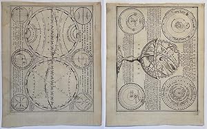
This plate shows two hemispheres, showing the equator, tropics and polar zones of the world, in the cusps and corners there are six smaller diagrams showing 'Disposition des Parallels' and 'Explication des Zones' etc. In the early eighteenth century, French cartography overtook the Dutch in terms of accuracy and design. Chiquet'…s delightful Nouveau et Curieux Atlas was typical product of the time. Moreland and Bannister, p.132 Size: 212 x 165 mm. (8½ x 6½ inches). Copper engraving. Original colour with later additions. Fine condition, good margins.
 More images
Published by c.1719 1719
Seller: Pictura Prints, Art & Books, Overasselt, , NetherlandsPictura Prints, Art & Books
Contact seller5-star sellerCondition: Used
£ 174.33
£ 17.36 shippingShips from Netherlands to U.S.A.Quantity: 1 available
'ESTATS DE L'EMPIRE DU GRAND SEIGNEUR DIT SULTAN ET OTTOMANS (.).'This coloured print shows a map of the Ottoman empire with Northern Africa, Arab countries, Turkey, the south of Europe, Georgia.Made by Anonymous after Jacques Chiquet.Medium: Engraving / etching / handcoloured on hand laid (verge) paper.Sheet size: 25.2 x 20 cm…(9.92 x 7.87 inch). Image size: 21.7 x 16.5 cm. (8.54 x 6.5 inch).OTTOMAN EMPIRE-ARABIA-MIDDLE EAST | RBOS-A8-22BACKGROUND INFORMATIONThis attractive print was published by J. Chiquet in Paris c.1719. This ed. has no legend at bottom left, but a inset map of the Sahara.Biography artist: Cartographer: Jacques Chiquet (c.1673-1721) was a French cartographer, engraver and print seller in Paris. Condition: fair, given age. Folds as published. Brownish spots. Remains of tape in corners. Upper left corner paper loss. General age-related toning and/or occasional minor defects from handling. Please study scan carefully. Jacques Chiquet (illustrator).

Published by Artist: Chiquet Jacques ( - 1721 ) Paris dated : 1719 1673
Seller: Antique Sommer& Sapunaru KG, München, , GermanyAntique Sommer& Sapunaru KG
Contact seller4-star sellerCondition: Used
£ 160.92
£ 39.06 shippingShips from Germany to U.S.A.Quantity: 1 available
Technic: Copper print, colorit: colored, condition: Very good, size (in cm): 16 x 22, Map shows total Hungary with Moldavia, Bulgaria, Rumania Serbia, Bosnia, Dalmatia and Slovenia.
Published by La Nouveau et Curieux Atlas Geographique et historique. [c.1719] 1719
Seller: Peter Harrington. ABA/ ILAB., London, United KingdomPeter Harrington. ABA/ ILAB.
Contact seller5-star sellerCondition: Used
£ 200.00
£ 22.00 shippingShips from United Kingdom to U.S.A.Quantity: 1 available
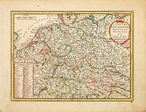
Map of Germany showing the different provinces - 'cercles' as the map refers to them, with a list of the emperors at lower left and title cartouche at upper right. In the early eighteenth century, French cartography overtook the Dutch in terms of accuracy and design. Chiquet's delightful Nouveau et Curieux Atlas was typical prod…uct of the time. Moreland and Bannister, p.132 Copper engraving. Fine condition, good margins. Original colour with later additions. Size: 22 x 16.5 cm. (8½ x 6½ inches).

Published by La Nouveau et Curieux Atlas Geographique et historique. [c.1719] 1719
Seller: Peter Harrington. ABA/ ILAB., London, United KingdomPeter Harrington. ABA/ ILAB.
Contact seller5-star sellerCondition: Used
£ 220.00
£ 22.00 shippingShips from United Kingdom to U.S.A.Quantity: 1 available
Map of European Russia, with a list of Dukes of Muscovy at lower left and a title cartouche at top right. In the early eighteenth century, French cartography overtook the Dutch in terms of accuracy and design. Chiquet's delightful Nouveau et Curieux Atlas was typical product of the time. Moreland and Bannister, p.132. Copper eng…raving. Fine condition, good margins. Original colour with later additions. Size: 22 x 16.5 cm. (8½ x 6½ inches).
Published by Parigi, 1719
- Art Print
Seller: libreria antiquaria perini Sas di Perini, Verona, VR, Italylibreria antiquaria perini Sas di Perini
Contact seller5-star sellerCondition: Used
£ 214.56
£ 34.72 shippingShips from Italy to U.S.A.Quantity: 1 available
Incisione in rame di mm 170x220, con lieve coloritura antica a mano dei confini. Cartiglio decorato recante il titolo in basso a sinistra. Jacques Chiquet (1673 - 1721) Ë stato un cartografo francese, autore di due opere geografiche chiamate "Le Nouveau et Curieux Atlas Geographique et Historique" e "Noveau Atlas Francais" pubbl…icate entrambe nel 1719. L'autore morÏ poco dopo questa data e, di conseguenza, le sue opere sono molto rare. Ottimo esemplare. Nr.cat: P6170055.

Published by Artist: Chiquet Jacques ( - 1721 ) Paris ca : 1719 1673
Seller: Antique Sommer& Sapunaru KG, München, , GermanyAntique Sommer& Sapunaru KG
Contact seller4-star sellerCondition: Used
£ 223.50
£ 39.06 shippingShips from Germany to U.S.A.Quantity: 1 available
Technic: Copper print, colorit: original colored, condition: Perfect condition, size (in cm): 16,5 x 22,5, Map shows the continent of Africa with its countries with a decorative title cartouche. From the atlas, Le Nouveau et Curieux Atlas Geographique et Historique.
- First Edition
- Art Print
Seller: Librairie Seigneur, VOINGT, , FranceLibrairie Seigneur
Contact seller5-star sellerCondition: Used
£ 89.40
£ 34.28 shippingShips from France to U.S.A.Quantity: 1 available
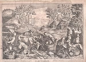
édition originale. Réalisée d'après les peintures de 1574 des peintres italiens Jacopo et Francesco Bassao; À Paris chez Chiquet rue Saint Jacques au grand S. Henry. 22 x 29.
Seller: Antiquariaat Arine van der Steur / ILAB, Den Haag, , NetherlandsAntiquariaat Arine van der Steur / ILAB
Contact seller4-star sellerCondition: Used
£ 140.62
£ 26.04 shippingShips from Netherlands to U.S.A.Quantity: 1 available
Two illustrations from an edition of Le nouveau et curieux atlas geographique et historique, ou le divertissement des empereurs, roys, et princes (Paris 1719 and later), namely the first and the third plate after the frontispiece.The first plate depicts the two hemispheres, showing the equator, tropics and polar areas of the wor…ld, in the cusps and corners there are six smaller diagrams showing the Disposition des Parallels and Explication de Zones. The second plate shows a comparison of the various systems adopted for the astrolabes: Systeme de Copernic, Systeme de Ticho Brahé, Systeme de Ptolomée, and Systeme composé.The publication was printed in fine laid paper. These impressions show folding traces, suggesting they were included in a in 8vo publication.[NL] Twee illustraties uit Le nouveau et curieux atlas geographique et historique, ou le divertissement des empereurs, roys, et princes, namelijk de eerste en de derde plaat na de titelpagina. Ets en gravure gemaakt door Jacques Chiquet (1673-1721). Mooie decoratieve wereldbol, twee platen. Etching and engraving on laid paper with some margin; total: 198 x 250 mm; some traces of water stains, overall in very good condition.


