Order Total (1 Item Items):
Shipping Destination:

Chester Wolverton (22 results)
Skip to main search results
Search filters
Product Type
- All Product Types
- Books (3)
- Magazines & Periodicals (No further results match this refinement)
- Comics (No further results match this refinement)
- Sheet Music (No further results match this refinement)
- Art, Prints & Posters (No further results match this refinement)
- Photographs (No further results match this refinement)
- Maps (19)
- Manuscripts & Paper Collectibles (No further results match this refinement)
Condition Learn more
- New (No further results match this refinement)
- As New, Fine or Near Fine (No further results match this refinement)
- Very Good or Good (2)
- Fair or Poor (No further results match this refinement)
- As Described (20)
Binding
Collectible Attributes
- First Edition (1)
- Signed (No further results match this refinement)
- Dust Jacket (No further results match this refinement)
- Seller-Supplied Images (22)
- Not Print on Demand (22)
Language (2)
Price
- Any Price
- Under � 20 (No further results match this refinement)
- � 20 to � 35 (No further results match this refinement)
- Over � 35
Free Shipping
- Free Shipping to U.S.A. (No further results match this refinement)
Seller Location
Seller Rating
-

Wolverton's Atlas of Monmouth County. New Jersey.
Language: English
Published by Lincroft, N.J., Gerrith Publishers and Harmony Press, 1986
Seller: West Coast Rare Books, Westport, MAYO, Ireland
Seller rating 3 out of 5 stars

Facsimile Edition of the 1889 Edition. 39 x 30 cm. Original stiff paper wrappers. Very good condition. Minor shelf wear and dust dulling to wrappers.
-
Two Atlases of Monmouth County New Jersey. 1. Wolverton's Atlas of Monmouth County. 2. Atlas of Monmouth Co. New Jersey.
Language: English
Published by Lincroft, N.J., Gerrith Publishers and Harmony Press, 1986
Seller: West Coast Rare Books, Westport, MAYO, Ireland
Seller rating 3 out of 5 stars
Facsimile Editions of both Atlases. 39 x 30 cm. Original stiff paper wrappers. Very good condition.
-
Wolverton's Atlas of Monmouth County New Jersey. Compiled from Actual Surveys, State and County Official Records and Private Plans
Published by Chester Wolverton, New York, 1889
Seller: Between the Covers-Rare Books, Inc. ABAA, Gloucester City, NJ, U.S.A.
Association Member: ABAA ESA ILAB IOBA
Seller rating 5 out of 5 stars

First Edition
Hardcover. Condition: Very Good. First edition. Large folio (16 �" x 21"). [4]pp., and 42 double-page color lithographic maps: plates 2-43. Lacking plate 1 (Outline map of Monmouth County). With an additional folded color lithographic map laid-in: "Driving Road Chart of Monmouth County, 1889". Light wear and fraying at the head and tail of spine, corners are bumped, slight stain on fore-edge of text block, very good or better, with all 42 maps in fine condition. A bright, near-complete copy, scarce in the trade.
-
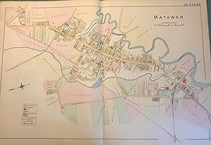
MATAWAN MAP, 1889
Published by Chester Wolverton, NY, 1889
Seller: Antic Hay Books, Asbury Park, NJ, U.S.A.
Seller rating 5 out of 5 stars
Map
Very Good condition. An original 30-inch by 22-inch linen-backed color map published in 1889. Map depicts Matawan. From Atlantic Avenue to the Matawan Creek; and from the railroad depot area to the Holmdel Turnpike area. Includes downtown areas. The original hand-colored map (Plate 28), not a reproduction! Wolverton maps are among the best you can get of Monmouth County. Very Good.
-
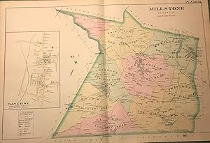
MILLSTONE TOWNSHIP/NAVESINK (MIDDLETOWN TOWNSHIP) NJ MAP. FROM WOLVERTON'S ?ATLAS OF MONMOUTH COUNTY,? 1889
Published by Chester Wolverton, NY, 1889
Seller: Antic Hay Books, Asbury Park, NJ, U.S.A.
Seller rating 5 out of 5 stars
Map
A nice copy! An original 30-inch by 22-inch linen-backed color map published in 1889. Map depicts Millstone Township from the Burksville area to the Mercer/Middlesex county border; and from the Upper Freehold Township border to the Manalapan Township border. Contains in set of the Navesink section of Middletown Township. The original hand-colored map (Plate 42), not a reproduction! Wolverton maps are among the best you can get of Monmouth County.
-
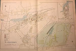
EATONTOWN/ MONMOUTH PARK/ OCEANPORT. NJ MAP. FROM WOLVERTON'S ?ATLAS OF MONMOUTH COUNTY,? 1889
Published by Chester Wolverton, NY, 1889
Seller: Antic Hay Books, Asbury Park, NJ, U.S.A.
Seller rating 5 out of 5 stars
Map
Nice condition! An original 30-inch by 22-inch linen-backed color map published in 1889. Map depicts Eatontown from the railroad tracks to Monmouth Park; and from the Buttonwood Road area to to the Mill Brook area. Also has insets of Monmouth Park and Oceanport. Shows structures erected at the time. The original hand-colored map (Plate 26), not a reproduction! Wolverton maps are among the best you can get of Monmouth County.
-
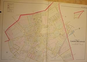
PART OF LONG BRANCH NJ MAP. FROM WOLVERTON'S ?ATLAS OF MONMOUTH COUNTY,? 1889
Published by Chester Wolverton, NY, 1889
Seller: Antic Hay Books, Asbury Park, NJ, U.S.A.
Seller rating 5 out of 5 stars
Map
Very Good. An original 30-inch by 22-inch linen-backed color map published in 1889. Map depicts Long Branch from High Street & Sixth Avenue to Myrtle Avenue; and from High Street to Joline Avenue. Shows types of structures erected at the time. The original hand-colored map (Plate 10), not a reproduction! Wolverton maps are among the best you can get of Monmouth County. Very Good.
-
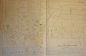
PART OF ATLANTIC HIGHLANDS NJ MAP. FROM WOLVERTON'S ATLAS OF MONMOUTH COUNTY
Published by Chester Wolverton, NY, 1889
Seller: Antic Hay Books, Asbury Park, NJ, U.S.A.
Seller rating 5 out of 5 stars
Map
Very Good. An original 30-inch by 22-inch linen-backed color map published in 1889. Map depicts Part of Atlantic Highlands, from the circular Prospect Park to Avenue D, and from Sandy Hook Bay to Garfield Avenue. Depicts types of structures erected at the time. The original map (Plate 3), not a reproduction! Wolverton maps are among the best you can get of Monmouth County.
-

Hempstead Village
Published by Chester Wolverton, New York, 1891
Seller: Alexandre Antique Prints, Maps & Books, Toronto, ON, Canada
Seller rating 4 out of 5 stars

Map
Size : 465x720 (mm), 18.25x28.375 (Inches), Original Hand Coloring Very Good, minor fraying of the edges not affecting the map.
-

Part of Long Island City Ward No. 5
Published by Chester Wolverton, New York, 1891
Seller: Alexandre Antique Prints, Maps & Books, Toronto, ON, Canada
Seller rating 4 out of 5 stars
Map
Size : 460x715 (mm), 18.125x28.125 (Inches), Original Hand Coloring Very Good, minor fraying of the edges not affecting the map.
-

Richmond Hill
Published by Chester Wolverton, New York, 1891
Seller: Alexandre Antique Prints, Maps & Books, Toronto, ON, Canada
Seller rating 4 out of 5 stars
Map
Size : 460x717 (mm), 18.125x28.25 (Inches), Original Hand Coloring Very Good, minor fraying of the edges not affecting the map.
-

Morris Park West Jamaica and Clarenceville
Published by Chester Wolverton, New York, 1891
Seller: Alexandre Antique Prints, Maps & Books, Toronto, ON, Canada
Seller rating 4 out of 5 stars
Map
Size : 460x735 (mm), 18.125x28.875 (Inches), Original Hand Coloring Very Good, minor fraying of the edges not affecting the map, lower joint reinforced.
-

Village of Newton / Villiage of Maspeth / Village of Malvina / Village of Winfield / Village of Woodside and Charlotteville / Village of Laurel Hill
Published by Chester Wolverton, New York, 1891
Seller: Alexandre Antique Prints, Maps & Books, Toronto, ON, Canada
Seller rating 4 out of 5 stars
Map
Size : 463x713 (mm), 18.25x28 (Inches), Original Hand Coloring Very Good, minor fraying of the edges not affecting the map.
-

Part of the Village of Far Rockaway Plate 12
Published by Chester Wolverton, New York, 1891
Seller: Alexandre Antique Prints, Maps & Books, Toronto, ON, Canada
Seller rating 4 out of 5 stars
Map
Size : 470x710 (mm), 18.5x27.875 (Inches), Original Hand Coloring Very Good, minor fraying of the edges not affecting the map.
-

Rockaway Beach
Published by Chester Wolverton, New York, 1891
Seller: Alexandre Antique Prints, Maps & Books, Toronto, ON, Canada
Seller rating 4 out of 5 stars
Map
Size : 460x720 (mm), 18.125x28.375 (Inches), Original Hand Coloring Very Good, minor fraying of the edges not affecting the map.
-

Woodhaven town of Jamaica
Published by Chester Wolverton, New York, 1891
Seller: Alexandre Antique Prints, Maps & Books, Toronto, ON, Canada
Seller rating 4 out of 5 stars
Map
Size : 455x710 (mm), 17.875x27.875 (Inches), Original Hand Coloring Very Good, minor fraying of the edges not affecting the map.
-

Seaford / Baldwins / Hewletts / Valley Stream / Pearsalls / Greenwich Point
Published by Chester Wolverton, New York, 1891
Seller: Alexandre Antique Prints, Maps & Books, Toronto, ON, Canada
Seller rating 4 out of 5 stars
Map
Size : 458x710 (mm), 18x27.875 (Inches), Original Hand Coloring Very Good, minor fraying of the edges not affecting the map.
-

Freeport / Rockville Centre
Published by Chester Wolverton, New York, 1891
Seller: Alexandre Antique Prints, Maps & Books, Toronto, ON, Canada
Seller rating 4 out of 5 stars
Map
Size : 462x720 (mm), 18.125x28.375 (Inches), Original Hand Coloring Very Good, minor fraying of the edges not affecting the map, joints reinforced.
-

Part of the Villiage of Far Rockaway 11
Published by Chester Wolverton, New York, 1891
Seller: Alexandre Antique Prints, Maps & Books, Toronto, ON, Canada
Seller rating 4 out of 5 stars
Map
Size : 465x715 (mm), 18.25x28.125 (Inches), Original Hand Coloring Very Good, minor fraying of the edges not affecting the map.
-

Part of Long Island City Ward No. 2
Published by Chester Wolverton, New York, 1891
Seller: Alexandre Antique Prints, Maps & Books, Toronto, ON, Canada
Seller rating 4 out of 5 stars
Map
Condition: Very Good. Size : 460x715 (mm), 18.125x28.125 (Inches), Original Hand Coloring.
-

Part of Long Island City Ward No. 1 and 3
Published by Chester Wolverton, New York, 1891
Seller: Alexandre Antique Prints, Maps & Books, Toronto, ON, Canada
Seller rating 4 out of 5 stars
Map
Size : 520x772 (mm), 20.5x30.375 (Inches), Original Hand Coloring Very Good, lower edge is frayed and brittle.
-

Part of Long Island City Ward No. 4
Published by Chester Wolverton, New York, 1891
Seller: Alexandre Antique Prints, Maps & Books, Toronto, ON, Canada
Seller rating 4 out of 5 stars
Map
Size : 460x740 (mm), 18.125x29.125 (Inches), Original Hand Coloring Very Good, minor fraying of the edges not affecting the map.