C V Monin (75 results)
Published by Paris, ca. . 1830
- Art Print
Seller: Antiquariat Hans-Jürgen Ketz, Münster, GermanyAntiquariat Hans-Jürgen Ketz
Contact seller5-star sellerCondition: Used
£ 10.66
£ 17.21 shippingShips from Germany to U.S.A.Quantity: 1 available
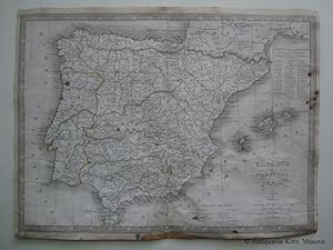
Add to basket** Fleckig, Einrisse mit Japanpapier unterlegt (kaum merklich) und im Knick beschabt. (SW: Landkarte/ map - Spanien/ Spain).

Published by J. Gaultier, Editeur, Paris
- Hardcover
Seller: LIVRES ANCIENS ET CONTEMPORAINS, HASPARREN, FranceLIVRES ANCIENS ET CONTEMPORAINS
Contact seller5-star sellerCondition: Used - Good
£ 25.33
£ 19.84 shippingShips from France to U.S.A.Quantity: 1 available
Add to basketCouverture rigide. Condition: Satisfaisant. Gravure sur acier de Laguillermie et Abel Malo, Paris ; carte en 32 plis sous cartonnage imprimé ; l'un des plis est recollé par derrière ; bon état général par ailleurs.
Published by E. Hocquart, marchand d'estampes et de cartes géographiques, 1835. Gravure 240x200 rassemblant 6 vignettes, un tableau de géographie physique et un tableau de géographie mathématique. 1835
Seller: LE SERPENT QUI PENSE, PRECHAC, FranceLE SERPENT QUI PENSE
Contact seller4-star sellerBON ETAT.
Published by E. Hocquart, marchand d'estampes et de cartes géographiques, 1835. Carte 255x195. Frontières rehaussées en couleurs. 1835
Seller: LE SERPENT QUI PENSE, PRECHAC, FranceLE SERPENT QUI PENSE
Contact seller4-star sellerCondition: Used
£ 13.33
£ 34.51 shippingShips from France to U.S.A.Quantity: 1 available
Add to basketBON ETAT.
Published by E. Hocquart, marchand d'estampes et de cartes géographiques, 1835. Carte 255x195. Frontières rehaussées en couleurs. 1835
Seller: LE SERPENT QUI PENSE, PRECHAC, FranceLE SERPENT QUI PENSE
Contact seller4-star sellerCondition: Used
£ 13.33
£ 34.51 shippingShips from France to U.S.A.Quantity: 1 available
Add to basketPetit manque à un coin sinon bon état .
Published by E. Hocquart, marchand d'estampes et de cartes géographiques, 1835. Carte 255x195. Frontières rehaussées en couleurs. 1835
Seller: LE SERPENT QUI PENSE, PRECHAC, FranceLE SERPENT QUI PENSE
Contact seller4-star sellerCondition: Used
£ 13.33
£ 34.51 shippingShips from France to U.S.A.Quantity: 1 available
Add to basketBON ETAT.
Published by E. Hocquart, marchand d'estampes et de cartes géographiques, 1835. Carte 255x195. Frontières rehaussées en couleurs. 1835
Seller: LE SERPENT QUI PENSE, PRECHAC, FranceLE SERPENT QUI PENSE
Contact seller4-star sellerCondition: Used
£ 13.33
£ 34.51 shippingShips from France to U.S.A.Quantity: 1 available
Add to basketBON ETAT.
Published by E. Hocquart, marchand d'estampes et de cartes géographiques, 1835. Carte 255x195. Limites départementales rehaussées en couleurs. 1835
Seller: LE SERPENT QUI PENSE, PRECHAC, FranceLE SERPENT QUI PENSE
Contact seller4-star sellerCondition: Used
£ 13.33
£ 34.51 shippingShips from France to U.S.A.Quantity: 1 available
Add to basketMarges sales sinon bon état .
Published by E. Hocquart, marchand d'estampes et de cartes géographiques, 1835. Carte 225x185. Frontières rehaussées en couleurs. 1835
Seller: LE SERPENT QUI PENSE, PRECHAC, FranceLE SERPENT QUI PENSE
Contact seller4-star sellerCondition: Used
£ 13.33
£ 34.51 shippingShips from France to U.S.A.Quantity: 1 available
Add to basketBON ETAT.

Published by Paris: Librairie Classique, 1839 1839
Seller: Pennymead Books PBFA, Knaresborough, United KingdomPennymead Books PBFA
Contact seller5-star sellerCondition: Used
£ 33.30
£ 15.00 shippingShips from United Kingdom to U.S.A.Quantity: 1 available
Add to basketEngraved map with inset of New South Wales. Contemporary colour. 15.5 x 11".

Language: German
Published by 1839., 1839
Seller: Alte Bücherwelt, Perg, AustriaAlte Bücherwelt
Contact seller4-star sellerCondition: Used
£ 33.76
£ 15.10 shippingShips from Austria to U.S.A.Quantity: 1 available
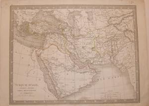
Add to basket43 x 31,5 cm Empire d`Alexandre dressee par C.V. Monin, Geographe, hrsg. ca. 1839, Original-Landkarte, Stahlstich, tlw. koloriert, mit Ansicht Iran (Persien), Format 43 x 31,5 cm sehr guter Zustand. Sprache: Deutsch Gewicht in Gramm: 550.

Condition: Used - Near fine
£ 49.32
£ 36.23 shippingShips from France to U.S.A.Quantity: 1 available
Add to basketCouverture rigide. Condition: bon. R320093318: VERS 1840-50. In-16. Relié. Bon état, Couv. convenable, Dos satisfaisant, Intérieur frais. 1 GRANDECARTE DEPLIANTE EN COULEUR DE DIMENSION 81 Cm X 60 Cm environ. Contre-collée sou splats cartonnés (coins frottés). Carte en bon etat. 2 PHOTOS DISPONIBLES - . . . . Classification Dewe…y : 940-Histoire générale de l'Europe.
Published by 1840 c.ca 1840
Seller: TABERNA LIBRARIA - ALAI - ILAB, Pistoia, ItalyTABERNA LIBRARIA - ALAI - ILAB
Contact seller5-star sellerAcquaforte cm. 53x69. Tavola comparativa. Piegature all'origine.

Published by [Paris, France: Monin.] 1848
- Manuscript
Seller: Wittenborn Art Books, San Francisco, U.S.A.Wittenborn Art Books
Contact seller5-star sellerCondition: Good. Map. Engraving On Folded Paper. 11" x 14.25". Good with minor tears.En Francais.

Published by [Paris, France: Monin.] 1848
- Manuscript
Seller: Wittenborn Art Books, San Francisco, U.S.A.Wittenborn Art Books
Contact seller5-star sellerCondition: Good. Map. Engraving On Folded Paper. 11" x 14.25"). Good with minor losses at top right corner.En Francais.

Published by [Paris, France: Monin.] 1848
- Manuscript
Seller: Wittenborn Art Books, San Francisco, U.S.A.Wittenborn Art Books
Contact seller5-star sellerCondition: Good. Map. Engraving On Folded Paper. 11" x 15". Good with minor tears at edges.En Francais.
Published by [Paris, France: Monin.] 1845
- Manuscript
Seller: Wittenborn Art Books, San Francisco, U.S.A.Wittenborn Art Books
Contact seller5-star sellerCondition: Good. Map. Engraving On Folded Paper. 11" x 14.25". Good with minor tears.En Francais.
Language: German
Published by ca. 1828. 1828
Seller: Alte Bücherwelt, Perg, AustriaAlte Bücherwelt
Contact seller4-star sellerCondition: Used
£ 41.76
£ 15.10 shippingShips from Austria to U.S.A.Quantity: 1 available
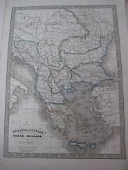
Add to basket46 x 33 cm. Turquie d`Europe ou Grece ou Hellade par C.V. Monin, hrsg. ca. 1828, tlw. koloriert, Format 46 x 33 cm, sehr guter Zustand. genuine map Sprache: Deutsch Gewicht in Gramm: 550.
Language: German
Seller: Alte Bücherwelt, Perg, AustriaAlte Bücherwelt
Contact seller4-star sellerCondition: Used
£ 27.54
£ 15.10 shippingShips from Austria to U.S.A.Quantity: 1 available
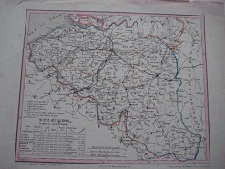
Add to basket32 x 25 cm. Original-Landkarte Belgique v. C.V. Molin, hrsg. 1866, Format 32 x 25 cm, Stahlst. grenzkol. guter-sehr guter Zustand, kl. Randlässuren. genuine map Sprache: Deutsch Gewicht in Gramm: 350.
Published by Paris, Delloye, Corbeil, Gaillard, 1836 1836
- Softcover
Seller: Librairie Historique F. Teissèdre, SAUVE, FranceLibrairie Historique F. Teissèdre
Contact seller5-star sellerCondition: Used
£ 133.28
£ 38.82 shippingShips from France to U.S.A.Quantity: 1 available
Add to basketin-12, VII-288 pp., 6 planches de vues et 3 cartes dépliantes, broché. Couverture abîmée, dos fendu avec manques. Rousseurs et mouillures angulaires. Deux planches sont volantes et plus courtes de marges. - - VENTE PAR CORRESPONDANCE UNIQUEMENT - LIEN DE PAIEMENT, NOUS CONSULTER.

Published by GARNIER FRERES
- Hardcover
- Map
Seller: Le-Livre, SABLONS, FranceLe-Livre
Contact seller5-star sellerCondition: Used - Near fine
£ 137.72
£ 36.23 shippingShips from France to U.S.A.Quantity: 1 available
Add to basketCouverture rigide. Condition: bon. RO80129986: XIXe siècle. In-4. Cartonné. Etat passable, Couv. défraîchie, Dos fané, Quelques rousseurs. 46 planches ou doubles-planches de cartes en couleurs. Ouvrage légèrement débroché. Coins et coupes des plats, frottés. Quelques traces d'humidité en marges. Traits au crayon à papier, au dos… des cartes. . . . Classification Dewey : 912-Atlas, cartes et plans.

Published by Parigi, Armand Aubree, Parigi 1837
- Hardcover
Seller: libreria minerva, Padova, Italylibreria minerva
Contact seller5-star sellerCondition: Used
£ 195.48
£ 25.88 shippingShips from Italy to U.S.A.Quantity: 1 available
Add to basketCondition: Buono (Good). acquaforte acquerellata a mano inciso cm. 67,2 x 50,7 - foglio cm. 75,7 x 55 Buono (Good) Buon es. con qualche segno del tempo. Book.
 More images
Published by Chez Binet n.d.
- Hardcover
Seller: Moe's Books, Berkeley, U.S.A.Moe's Books
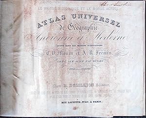
Contact seller4-star sellerHardcover. Condition: Good. No jacket. Circa 1838. "Adopte dans les maisons d'education." In French. 37 maps collated complete. Covers worn, especially along edges. Front flyleaf missing 1/3. Some foxing. As-Is.
 More images
Published by Paris, Paris 1841
- Hardcover
Seller: High Ridge Books, Inc. - ABAA, South Deerfield, U.S.A.High Ridge Books, Inc. - ABAA
Contact seller5-star sellerOriginal 1/4 leather with pebbled cloth. Some damage with loss to preliminary text leaves, some repairs. One folding cosmological plate, 12 maps of the ancient world, 37 of the modern, all hand-colored in outline.
 More images
Language: French
Published by Paris, Lecoffre, ca. 1860. 1860
Seller: Altstadt Antiquariat M. Weiers, Freiburg, GermanyAltstadt Antiquariat M. Weiers
Contact seller5-star sellerCondition: Used - Very good
£ 97.74
£ 17.25 shippingShips from Germany to U.S.A.Quantity: 1 available
Add to basket24 x 16 cm. Orig.-Pappband. Condition: Gut. Avec 10 cartes en double page. Die Stahlstich-Karten sind grenzkoloriert. - Einband berieben. Vorderes Innengelenk angeplatzt. 2 restaurierte Einrisse des Titelblattes. Vorsätze stockfleckig. Die Karten nur vereinzelt leicht stockfleckig. L Sprache: Französisch Gewicht in Gramm: 200 No…uvelle édition, composée de cartes gravées d`après de nouveaux dessins.
Published by AUBREE Armand 1837
- Map
Seller: Le-Livre, SABLONS, FranceLe-Livre
Contact seller5-star sellerCondition: Used - Near fine
£ 57.98
£ 36.23 shippingShips from France to U.S.A.Quantity: 1 available
Add to basketPas de couverture. Condition: bon. RO80039272: 1837. In-Plano. En feuillets. Etat passable, Livré sans Couverture, Dos satisfaisant, Fortes mouillures. 2 cartes en double-planches, noir et blanc, hors-texte. Accroc sur marges en en-tête. (45 / 32 cm, chaque carte). . . A l'italienne. Classification Dewey : 912-Atlas, cartes et p…lans.
Published by AUBREE Armand 1837
Seller: Le-Livre, SABLONS, FranceLe-Livre
Contact seller5-star sellerCondition: Used - Near fine
£ 57.98
£ 36.23 shippingShips from France to U.S.A.Quantity: 1 available
Add to basketPas de couverture. Condition: bon. RO80039276: 1837. In-Plano. En feuillets. Etat d'usage, Livré sans Couverture, Dos satisfaisant, Mouillures. Carte en double-planche, noir et blanc, hors-texte. Mouillures en marges en-tête (45/32 cm). . . . Classification Dewey : 970-Histoire générale de l'Amérique du Nord.
Published by AUBREE Armand 1837
- Map
Seller: Le-Livre, SABLONS, FranceLe-Livre
Contact seller5-star sellerCondition: Used - Near fine
£ 57.98
£ 36.23 shippingShips from France to U.S.A.Quantity: 1 available
Add to basketPas de couverture. Condition: bon. RO80039273: 1837. In-Plano. En feuillets. Etat passable, Livré sans Couverture, Dos satisfaisant, Fortes mouillures. 2 cartes en double-planches, noir et blanc, hors-texte. Accrocs et déchirures sur marges en en-tête. (45 / 32 cm chaque carte). . . . Classification Dewey : 912-Atlas, cartes et…plans.
Published by AUBREE Armand 1837
- Map
Seller: Le-Livre, SABLONS, FranceLe-Livre
Contact seller5-star sellerCondition: Used - Near fine
£ 57.98
£ 36.23 shippingShips from France to U.S.A.Quantity: 1 available
Add to basketPas de couverture. Condition: bon. RO80039285: 1837. In-Plano. En feuillets. Etat d'usage, Livré sans Couverture, Dos satisfaisant, Mouillures. Carte , noir et blanc, hors-texte. Mouillures en marges en-tête. (45 / 33 cm). . . . Classification Dewey : 912-Atlas, cartes et plans.
Published by AUBREE Armand 1837
- Map
Seller: Le-Livre, SABLONS, FranceLe-Livre
Contact seller5-star sellerCondition: Used - Near fine
£ 75.52
£ 36.23 shippingShips from France to U.S.A.Quantity: 1 available
Add to basketPas de couverture. Condition: bon. RO80039288: 1837. In-Plano. En feuillets. Etat d'usage, Livré sans Couverture, Dos satisfaisant, Fortes mouillures. Carte en double-planche, noir et blanc, hors-texte. Mouillures en marges en-tête. (45 / 65 cm). . . A l'italienne. Classification Dewey : 912-Atlas, cartes et plans.


