C B Colton (240 results)
 More images
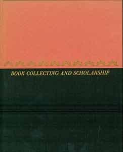
Book Collecting And Scholarship
Blegen, Theodore C. and James Ford Bell and Stanley Pargellis and Colton Storm and Louis B. Wright
Language: English
Published by University of Minnesota Press, Minneapolis 1954
- Hardcover
- First Edition
Seller: Legacy Books, Louisville, KY, U.S.A.Legacy Books
Contact seller5-star sellerHardcover. Condition: Good. 1st Edition. First edition, 12mo, 67pp, pink paper over boards and black cloth, with gilt titles, reddish pastedowns and endpapers, light general wear, housed in clear protective mylar dust jacket.

Language: English
Published by VKM, Fort Worth 1979
- Softcover
Seller: Young & Sons Enterprises, Apache, OK, U.S.A.Young & Sons Enterprises
Contact seller4-star sellerCondition: Used - Very good
£ 15.51
£ 4.15 shippingShips within U.S.A.Quantity: 1 available
Stapled Booklet. Condition: Very Good +. No Jacket. Facsimile. Reprint of the 1869 map. This is a very nice copy in booklet form, 1979, with minimal evidence of have been used. No names or writing within. NOT hole-punched. Size: 4to - over 9¾" - 12" tall.
Published by The Bookman Publishing, NY 1931
- Softcover
Seller: North Country Books, Milton, VT, U.S.A.North Country Books
Contact seller3-star sellerPaperback. Condition: Fair. Stapled magazine, missing front cover, wear to rear cover and partial damp staining affecting the magazine at the top blank margins. An acceptable reading copy.

- Softcover
Seller: PBShop.store US, Wood Dale, IL, U.S.A.PBShop.store US
Contact seller5-star sellerCondition: New
£ 22.78
Free ShippingShips within U.S.A.Quantity: 15 available
PAP. Condition: New. New Book. Shipped from UK. Established seller since 2000.
- Softcover
Seller: PBShop.store UK, Fairford, GLOS, United KingdomPBShop.store UK
Contact seller5-star sellerCondition: New
£ 21.11
£ 3.29 shippingShips from United Kingdom to U.S.A.Quantity: 15 available
PAP. Condition: New. New Book. Shipped from UK. Established seller since 2000.
Published by National Geographic Society 1944
- Softcover
Seller: JR Books, Grand Rapids, MI, U.S.A.JR Books
Contact seller5-star sellerpaperback. Condition: Good. Spine and cover repaired with clear tape.
Book Collecting and Scholarship
Blegen, Theodore C.; James Ford Bell, Stanley Pargellis, Colton Storm & Louis B.
Published by University of Minnesota Pres 1954
- Hardcover
Seller: Book Alley, Pasadena, CA, U.S.A.Book Alley
Contact seller4-star sellerHardcover. Condition: Good. NO DUST JACKET. Good used with wear and signs of age but is still in solid reading condition.

- Hardcover
Seller: PBShop.store US, Wood Dale, IL, U.S.A.PBShop.store US
Contact seller5-star sellerCondition: New
£ 31.06
Free ShippingShips within U.S.A.Quantity: 15 available
HRD. Condition: New. New Book. Shipped from UK. Established seller since 2000.
Book Collecting and Scholarship
Blegen, Theodore C.; James Ford Bell, Stanley Pargellis, Colton Storm & Louis B.
Published by University of Minnesota Pres
Seller: Wonder Book, Frederick, MD, U.S.A.Wonder Book
Contact seller5-star sellerCondition: Used - Very good
£ 15.52
Free ShippingShips within U.S.A.Quantity: 1 available
Condition: Very Good. Very Good condition. No Dust Jacket (book collecting ) A copy that may have a few cosmetic defects. May also contain light spine creasing or a few markings such as an owner's name, short gifter's inscription or light stamp.
- Hardcover
Seller: PBShop.store UK, Fairford, GLOS, United KingdomPBShop.store UK
Contact seller5-star sellerCondition: New
£ 28.12
£ 4.16 shippingShips from United Kingdom to U.S.A.Quantity: 15 available
HRD. Condition: New. New Book. Shipped from UK. Established seller since 2000.
BOOK COLLECTING AND SCHOLARSHIP
Books About Books ( Blegen, Theodore C. & Bell, James Ford & Pargellis, Stanley & Storm, Colton & Wright, Louis B. )
Published by University of Minnesota Press 1954
- Hardcover
- First Edition
Seller: THE FINE BOOKS COMPANY / A.B.A.A / 1979, ROCHESTER, MI, U.S.A.THE FINE BOOKS COMPANY / A.B.A.A / 1979
Contact seller4-star sellerFIRST EDITION. BOOK COLLECTING AND SCHOLARSHIP, University of Minnesota Press, 1954, first edition, some fading to the upper section of the spine (the boards section), else fine in like dust-wrapper. 1/750 copies.

- Softcover
- Print on Demand
Seller: Forgotten Books, London, United KingdomForgotten Books
Contact seller4-star sellerCondition: New
£ 14.33
Free ShippingShips from United Kingdom to U.S.A.Quantity: Over 20 available
Paperback. Condition: New. Print on Demand. This book provides an overview of Christian missionary stations that were founded in various parts of the world during the 19th century. The stations were established by a range of different Christian denominations with the aim of spreading Christianity and providing social services su…ch as education and healthcare to local communities. The author has carefully compiled a comprehensive list of these stations, including their locations, the denominations that founded them, and the dates they were established. This information is presented on a series of detailed maps that illustrate the global reach of Christian missionary activity during this period. The book also explores the complex history of Christian missions, discussing the motivations of the missionaries, the challenges they faced, and the impact their work had on both the local communities and the development of Christianity worldwide. Overall, this book serves as a valuable resource for anyone interested in the history of Christian missions and its global impact. This book is a reproduction of an important historical work, digitally reconstructed using state-of-the-art technology to preserve the original format. In rare cases, an imperfection in the original, such as a blemish or missing page, may be replicated in the book. print-on-demand item.
Book Collecting and Scholarship.
Blegen, Theodore C.; Bell, James Ford; Pargellis, Stanley; Storm, Colton; Wright, Louis B.
Published by Minneapolis: University of Minnesota Press. 1954
- Hardcover
Seller: Wittenborn Art Books, San Francisco, CA, U.S.A.Wittenborn Art Books
Contact seller4-star sellerCondition: Good. 12mo. 67 pp. Black and red cloth-covered boards with gilt spine and gilt lettering on front board. Very good with light sunning. In brodart jacket with red laid endpapers. Red illustrated capitals. Copy number 46 of a special edition of 750 copies. From the collection of the late Frederick Ruffner, Jr., founder…of Gale Research, Detroit.
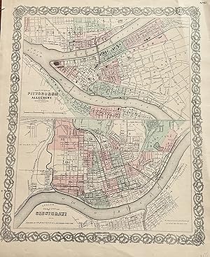
Published by Colton, J. H., New York 1855
- Map
Seller: mediumraremaps.com, Franklin, TN, U.S.A.mediumraremaps.com
Contact seller4-star seller12 1/2 X 15 3/4 INCHES. This map page has two maps. The upper map is of Pitts burgh and Allegheny. It is accopnyied by the lower half map of Cincinnati. Most important is the connection between the two cities; both were mated physically and economically by the Ohio River. These are very nice maps suitable for framing. it was han…d colored in 1855 when the map was produced. Very good with a couple of repaired tears using archival mending tape.

Published by G.W. & C.B. Colton & Co.,, New York: 1866
Seller: Nicholas D. Riccio Rare Books, ABAA, Florham Park, NJ, U.S.A.Nicholas D. Riccio Rare Books, ABAA
Contact seller4-star sellerUnbound, colored engraved map, decorative boarder, 16"x 13". Slight toning and aging, some creasing and chipping at the edge of the left margin; overall bright and clean and in very good condition. Maps are wrapped with acid free board, or in rigid sleeves. Beginning with J. H. Colton (1800-1893), the Colton family published atl…ases for over 30 years. Colton's Atlas of the World was first published in 1855 in a large two volume set. In 1857 it became Colton's General Atlas, and Colton's sons, George Woolworth and Charles B. would take over the business. This map of the North Western portion of Africa is from the 1866 edition of Colton's General Atlas, even though the copyright date on the map is 1855. The map is fairly colorful with a fair amount of detail on Tropoli, Sudan and Guinea. Ristow 313-326.

Published by G.W. & C.B. Colton & Co.,, New York: 1866
Seller: Nicholas D. Riccio Rare Books, ABAA, Florham Park, NJ, U.S.A.Nicholas D. Riccio Rare Books, ABAA
Contact seller4-star sellerUnbound, colored engraved map, decorative boarder, 16"x 13". Slight toning and aging, a little light foxing in margin, some creasing and chipping at the edge of the left margin; overall bright and clean and in very good condition. Maps are wrapped with acid free board, or in rigid sleeves. Beginning with J. H. Colton (1800-1893)…, the Colton family published atlases for over 30 years. Colton's Atlas of the World was first published in 1855 in a large two volume set. In 1857 it became Colton's General Atlas, and Colton's sons, George Woolworth and Charles B. would take over the business. This map of the North Western portion of Africa is from the 1866 edition of Colton's General Atlas, even though the copyright date on the map is 1855. The map is fairly colorful with a decorative border and shows part of Arabia, Nubia and an inset shows the Nile Delta. Ristow 313-326.
Published by National Geographic Society, 1944 1944
- Softcover
- First Edition
Seller: Bluff Park Rare Books, LONG BEACH, CA, U.S.A.Bluff Park Rare Books
Contact seller4-star sellerSoft Cover. No Jacket. First Edition. Soft Cover. No Jacket. First Edition. Magazine, Cover light Rub Scuff Marks & Circle Residue Coffee Cup ?, wear slight Aging , VG/NF-, AS-IS, SOFTCOVER, Interior Nice Tight Clean light FoX Wear, 384 pages + Ads, , also articles Rhodesia & Cecil John Rhodes, Bare Feet & Burros of Haiti, inclu…des Photo Tom Blake on Surfboard with his World Champion Spaniel Dog Surfer, Rusty , ETC. ALSO Series on Working & Wild Dogs with color Photos, includes 24 pages in Color & many B/W photos , Magazine Editor Gilbert Grosvenor, with illust from Paintings by Walter A. Weber.
 More images
Language: English
Published by Colton, New York 1866
- Hardcover
- First Edition
Seller: Bohemian Bookworm, Flemington, NJ, U.S.A.Bohemian Bookworm
Contact seller1-star sellerCondition: Used - Very good
£ 482.50
£ 3.02 shippingShips within U.S.A.Quantity: 1 available
Hardcover. Condition: Very Good. No Jacket. 1st Edition. Wonderful oversized pocket-sized map and engraved ornamental headings, several folds into original brown cloth small folder, VG, a few wrinkles but doesn't appear to be torn or missing pieces, 1st edn, about b30" x 35" hand coloured map.
Language: English
Published by G. W. and C. B. Colton, New York 1867
- Hardcover
Seller: Bohemian Bookworm, Flemington, NJ, U.S.A.Bohemian Bookworm
Contact seller1-star sellerCondition: Used - Very good
£ 598.37
£ 3.02 shippingShips within U.S.A.Quantity: 1 available
Hardcover. Condition: Very Good. VG, f/o colour map of the region in original 24mo brown gilt titled covers newly rebacked, about 25" x 32", excellent map of Reconstruction South.

Published by New York, New York 1870
- Hardcover
Seller: High Ridge Books, Inc. - ABAA, South Deerfield, MA, U.S.A.High Ridge Books, Inc. - ABAA
Contact seller5-star seller35x28.2 cm. Original cloth folder, front board detached. Fair condition overall. Repairs along several folds, small loss at two fold junctions in New York State. Full color by town. Inside front cover has a small contemporary bookseller's paste-down from Greenfield, Massachusetts. This is a folding version of the map of Vermont…which appeared in Colton's General Atlas.
Language: English
Seller: White Mountains, NH Books and Maps, Lincoln, NH, U.S.A.White Mountains, NH Books and Maps
Contact seller4-star sellerCondition: Used - Near fine
£ 49.18
£ 6.04 shippingShips within U.S.A.Quantity: 1 available
No Binding. Condition: Near Fine. Measuring 14-1/2"/W margins. Borders and counties are colored. No damage, very clean with a bit of tanning around edges, normal for this age paper.
Published by National Geographic Society 1944
- Softcover
- First Edition
Seller: Bluff Park Rare Books, LONG BEACH, CA, U.S.A.Bluff Park Rare Books
Contact seller4-star sellerSoft Cover. No Jacket. First Edition. Magazine, Cover light Rub, wear slight Aging , VG+/NF, AS-IS, SOFTCOVER, Interior Nice Tight Clean light FoX Wear, 384 pages + Ads, Tiny Tear Back Cover Edge , also articles Rhodesia & Cecil John Rhodes, Bare Feet & Burros of Haiti, includes Photo Tom Blake on Surfboard with his World Champi…on Spaniel Dog Surfer, Rusty , ETC. ALSO Series on Working & Wild Dogs with color Photos, includes 24 pages in Color & many B/W photos , Magazine Editor Gilbert Grosvenor, with illust from Paintings by Walter A. Weber.

Published by G.W. & C.B. Colton & Co.,, New York: 1866
Seller: Nicholas D. Riccio Rare Books, ABAA, Florham Park, NJ, U.S.A.Nicholas D. Riccio Rare Books, ABAA
Contact seller4-star sellerUnbound, double page (16" x 27"), engraved map, light coloring. Normal aging and darkening, corner fold; otherwise very good.ÃÂ Beginning with J. H. Colton (1800-1893), the Colton family published atlases for over 30 years. Colton's Atlas of the World was first published in 1855 in a large two volume set. In 1857 it became Colto…n's General Atlas, and Colton's sons, George Woolworth and Charles B. would take over the business. This unusual map of world, which consists of six panels showing a range of natural factirs affecting the world including ocean currents,ÃÂ to land mass and meteorology, is from the 1866 edition of Colton's General Atlas. The map has light coloring and a decorative border. Extra postage may be required.ÃÂ Ristow 313-326.
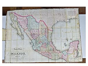
Language: Spanish
Published by G. W. & C. B. Colton & Co. 1871
- Hardcover
Seller: Shelley and Son Books (IOBA), Hendersonville, NC, U.S.A.Shelley and Son Books (IOBA)
Contact seller5-star sellerCondition: Used - Very good
£ 3,887.70
£ 4.91 shippingShips within U.S.A.Quantity: 1 available
Hardcover. Condition: Very Good. Early Edition, 1871. HAND-COLORED, BEAUTFULLY INTACT MAP OF MEXICO, 1871. By George Woolworth Colton and Charles B. Colton. Written in Spanish. This very large (37" wide x 50.5" long) lithograph folding map is housed in a hardcover, brown publisher's cloth binding. Cover is lettered in gilt with…blind debossed ornamentation. Spine is plain. Map is printed on an onion skin vellum, folded four times at the width, and thirteen times at its length. The map itself bears a lovely ornamented boarder in black along top and side edges. Includes scale and latitude and longitudinal coordinates data. When folded within the closed book, dimensions are 8.25" x 5" x 0.5".ABOUT THE CARTOGRAPHERS: George Woolworth Colton (1827-1901) was the son of Joseph H. Colton (1800-1893), one of the more prominent American cartographers in the mid-19th century. The elder Colton headed J. H. Colton and Company and began publishing maps in New York in the 1830s. The firm originally excelled in acquiring copyrights of previously published maps. Included was the map plates of David H. Burr, another prominent American cartographer. The elder Colton's first product was an 1833 reprint of David Burr's 1830 map of New York State, re-engraved by Samuel Stiles. Colton reprinted several other Burr maps, including New York and Ohio, which were reissued for more than two decades. From 1850 to 1887, a major specialty of the Colton firm was the production of pocket railroad maps and guides. The Colton publishing firm was taken over in the middle of the century by Joseph Colton's two sons, George W. Colton and Charles B. Colton. It was 28 year old George Colton who organized and compiled the most popular product of J. H. Colton Company, namely Colton's Atlas of the World, the first volume of which appeared in 1855 and focused on North and South America. (Map History, UCLA) CONDITION: Two small tears toward the center at the two fold corners right below the "M" and the "E" within the "Golfo de Mexico", yet the integrity of the map remains uncompromised. Some occasional foxing as to be expected, with minor crimping at the top right edge, yet in stunning condition for its age. Binding shows general wear and is reinforced by vintage publisher's cloth at the joints and inner hinges. Previous owner's name written in pencil on the front pastedown. Hand painted colors are exquisite. An absolutely lovely, rare copy. The background has been included within the photograph to help give size perspective, as it is stretched out on a long table. Please note that the open book at the left is the actual binding, housing the folded map. As this piece is very large and fragile, we prefer to NOT offer additional photographs, as two people are needed to unfold this very delicate map, and we wish to protect it from any possible damage in the folding process. Requests for additional photographs of the binding are welcomed. This item will be delivered with "adult signature required". Full refund if not satisfied.
Language: English
Seller: White Mountains, NH Books and Maps, Lincoln, NH, U.S.A.White Mountains, NH Books and Maps
Contact seller4-star sellerCondition: Used - Near fine
£ 56.75
£ 6.04 shippingShips within U.S.A.Quantity: 1 available
No Binding. Condition: Near Fine. A nice example with hand-colored map folded into dark brown blind-stamped stiff bds. VG+ condition, bds are quite rough with wear, poor.
Published by J.H. Colton & Co.,, New York: 1866
Seller: Nicholas D. Riccio Rare Books, ABAA, Florham Park, NJ, U.S.A.Nicholas D. Riccio Rare Books, ABAA
Contact seller4-star sellerUnbound, colored engraved map, decorative boarder, 16"x 13". Slight toning and aging, top margin with a few minor chips and tears, a couple of small repaired tears in bottom margin, not affecting image or border; otherwise bright and clean and in very good condition. Maps are wrapped with acid free board, or in rigid sleeves. Be…ginning with J. H. Colton (1800-1893), the Colton family published atlases for over 30 years. Colton's Atlas of the World was first published in 1855 in a large two volume set. In 1857 it became Colton's General Atlas, and Colton's sons, George Woolworth and Charles B. would take over the business. This map of Germany is from the 1866 edition of Colton's General Atlas. The map is colorful with a fair amount of detail, and includes coverage of Bavaria, Frankfurt and Wurtemberg. Extra postage may be required. Ristow 313-326.
Published by J.H. Colton & Co.,, New York: 1866
Seller: Nicholas D. Riccio Rare Books, ABAA, Florham Park, NJ, U.S.A.Nicholas D. Riccio Rare Books, ABAA
Contact seller4-star sellerUnbound, colored engraved map, decorative boarder, 16"x 13". Slight toning, darkening and aging, top margin has a few small chips and tears a corner chip, and two small repaired tears, minor creasing; otherwise bright and clean and in very good condition. Maps are wrapped with acid free board, or in rigid sleeves. Beginning with… J. H. Colton (1800-1893), the Colton family published atlases for over 30 years. Colton's Atlas of the World was first published in 1855 in a large two volume set. In 1857 it became Colton's General Atlas, and Colton's sons, George Woolworth and Charles B. would take over the business. This map of Germany is from the 1866 edition of Colton's General Atlas. The map is colorful with a fair amount of detail, and includes the regions of Hanover, Hamburg and Holstein. Extra postage may be required. Ristow 313-326.
Published by J.H. Colton & Co.,, New York: 1866
Seller: Nicholas D. Riccio Rare Books, ABAA, Florham Park, NJ, U.S.A.Nicholas D. Riccio Rare Books, ABAA
Contact seller4-star sellerUnbound, colored engraved map, decorative boarder, 16"x 13". Slight darkening and aging, a few minor chips and tears on upper margin edge, a little creasing; overall generally bright and clean and in very good condition. Maps are wrapped with acid free board, or in rigid sleeves. Beginning with J. H. Colton (1800-1893), the Colt…on family published atlases for over 30 years. Colton's Atlas of the World was first published in 1855 in a large two volume set. In 1857 it became Colton's General Atlas, and Colton's sons, George Woolworth and Charles B. would take over the business. This map of Indiana is from the 1866 edition of Colton's General Atlas, even though the copyright date on the map is 1855. The is a colorful map of Northern Italy show territory from Naples to Lombardy from the 1857 installment of Colton's atlas. The island of Corsica is also visble on the map. May require extra postage. Ristow 313-326.

Published by G.W. & C.B. Colton & Co.,, New York: 1866
Seller: Nicholas D. Riccio Rare Books, ABAA, Florham Park, NJ, U.S.A.Nicholas D. Riccio Rare Books, ABAA
Contact seller4-star sellerUnbound, colored engraved map, decorative boarder, 16"x 13". Slight toning and aging, a little creasing at the edge of the top margin; overall bright and clean and in very good condition. Maps are wrapped with acid free board, or in rigid sleeves. Beginning with J. H. Colton (1800-1893), the Colton family published atlases for o…ver 30 years. Colton's Atlas of the World was first published in 1855 in a large two volume set. In 1857 it became Colton's General Atlas, and Colton's sons, George Woolworth and Charles B. would take over the business. This map of the North Western portion of Africa is from the 1866 edition of Colton's General Atlas, even though the copyright date on the map is 1855. The map is fairly colorful and presents an interesting view of a still somewhat unkown South Africa. A significant portion of the map is shown as an unexplored region, but there is a fair anount of detail on Madagascar, Mozambique and Cape Colony. The names of some tribes are mentioned. Ristow 313-326.
Published by Colton G.W. & C.B., New York 1866
Seller: Nicholas D. Riccio Rare Books, ABAA, Florham Park, NJ, U.S.A.Nicholas D. Riccio Rare Books, ABAA
Contact seller4-star sellerUnbound, colored engraved map, decorative boarder, 16"x 13". Slight toning and aging, a little staining in margins; overall bright and clean and in very good condition. Maps are wrapped with acid free board, or in rigid sleeves. Beginning with J. H. Colton (1800-1893), the Colton family published atlases for over 30 years. Colto…n's Atlas of the World was first published in 1855 in a large two volume set. In 1857 it became Colton's General Atlas, and Colton's sons, George Woolworth and Charles B. would take over the business. This is an attractive map of Austria and is probably from the 1866 edition of Colton's General Atlas, even though the copyright date on the map indicates 1855. The map is colorful, and includes a small inset map of Vienna. Ristow 313-326.


