Bowen Emmanuel (26 results)
 More images
Language: English
Published by Printed & sold by Thomas Bowles 1720
- Map
Seller: GN Books and Prints, Inverness, United KingdomGN Books and Prints
Contact seller5-star sellerCondition: Used
Original price: £ 29.98; 25% offCurrent price: £ 22.49
£ 19.20 shippingShips from United Kingdom to U.S.A.Quantity: 1 available
No Binding. Condition: As Described. No Jacket. A double-sided antique map containing a very detailed map of the county of Surrey with information on the road from London to Chichester on recto and a strip road map of parts of Surrey and Sussex on verso. Taken from a copy of "Britannia Depicta, or Ogilby Improv'd Being a Correct… Coppy of Mr. Ogilby's Actual Survey of all ye Direct & Principal Cross Roads in England and Wales." by John Owen, engraved by Emmanuel Bowen. Printed & sold by Thomas Bowles, print & map seller in St Pauls Churchyard. Published somewhere between 1720-1753. Contains decorative border surrounding title, scale in English Miles, reference to the Hundreds, rose compasses with fleurs-de-lis pointing north and distances between locations as well as coats of arms and information on the counties. Measures around 5 7/8" x 7 1/2" (149mm x 190mm). Pages no. 95 and 96. The map contains no folds. There are signs of wear, some tattering to gutter edge, with slight loss. Some toning and a little foxing and other marking but reasonably clean for age. See pictures for further information. Circa 1720-1753. Emmanuel Bowen (illustrator).
 More images
Language: English
Published by Printed & sold by Thomas Bowles 1720
- Map
Seller: GN Books and Prints, Inverness, United KingdomGN Books and Prints
Contact seller5-star sellerCondition: Used
Original price: £ 29.98; 25% offCurrent price: £ 22.49
£ 19.20 shippingShips from United Kingdom to U.S.A.Quantity: 1 available
No Binding. Condition: As Described. No Jacket. A double-sided antique map containing a very detailed map of the county of Staffordshire with information on the road from London to Carlisle on recto and a strip road map of part of Lincolnshire on verso. Taken from a copy of "Britannia Depicta, or Ogilby Improv'd Being a Correct…Coppy of Mr. Ogilby's Actual Survey of all ye Direct & Principal Cross Roads in England and Wales." by John Owen, engraved by Emmanuel Bowen. Printed & sold by Thomas Bowles, print & map seller in St Pauls Churchyard. Published somewhere between 1720-1753. Contains decorative border surrounding title, scale in English Miles, reference to the Hundreds, rose compasses with fleurs-de-lis pointing north and distances between locations as well as coats of arms and information on the counties. Measures around 5 5/8" x 7 3/4" (143mm x 198mm). Pages no. 89 and 90. The map contains no folds. There are signs of wear, especially to one edge, with slight loss. Some toning and a little foxing and other marking but reasonably clean for age. Pieces of binding or mounting tape on recto. See pictures for further information. Circa 1720-1753. Emmanuel Bowen (illustrator).
 More images
Language: English
Published by Printed & sold by Thomas Bowles 1720
- Map
Seller: GN Books and Prints, Inverness, United KingdomGN Books and Prints
Contact seller5-star sellerCondition: Used
Original price: £ 29.98; 25% offCurrent price: £ 22.49
£ 19.20 shippingShips from United Kingdom to U.S.A.Quantity: 1 available
No Binding. Condition: As Described. No Jacket. A double-sided antique map containing a very detailed map of the county of Middlesex with information on the road from London to Bristol on recto and a strip road map of part of Northumberland on verso. Taken from a copy of "Britannia Depicta, or Ogilby Improv'd Being a Correct Cop…py of Mr. Ogilby's Actual Survey of all ye Direct & Principal Cross Roads in England and Wales." by John Owen, engraved by Emmanuel Bowen. Printed & sold by Thomas Bowles, print & map seller in St Pauls Churchyard. Published somewhere between 1720-1753. Contains decorative border surrounding title, scale in English Miles, reference to the Hundreds, rose compasses with fleurs-de-lis pointing north and distances between locations as well as coats of arms and information on the counties. Measures around 5 1/2" x 7 1/2" (140mm x 190mm). Pages no. 21 and 22. The map contains no folds. There are signs of wear, especially to one edge. Some toning and a little foxing and other marking but reasonably clean for age. See pictures for further information. Circa 1720-1753. Emmanuel Bowen (illustrator).
 More images
Language: English
Published by Printed & sold by Thomas Bowles 1720
- Map
Seller: GN Books and Prints, Inverness, United KingdomGN Books and Prints
Contact seller5-star sellerCondition: Used
Original price: £ 39.98; 25% offCurrent price: £ 29.99
£ 19.20 shippingShips from United Kingdom to U.S.A.Quantity: 1 available
No Binding. Condition: As Described. No Jacket. A double-sided antique strip road map containing parts of the counties of Gloucestershire and Oxfordshire with information on towns including Cirencester and Bristol. Taken from a copy of "Britannia Depicta, or Ogilby Improv'd Being a Correct Coppy of Mr. Ogilby's Actual Survey of…all ye Direct & Principal Cross Roads in England and Wales." by John Owen, engraved by Emmanuel Bowen. Printed & sold by Thomas Bowles, print & map seller in St Pauls Churchyard. Published somewhere between 1720-1753. Hand-coloured. Contains rose compasses with fleurs-de-lis pointing north and distances between locations as well as coats of arms and information on the counties. Measures around 5 1/4" x 7 5/8" (134mm x 194mm). Pages no. 141 and 142. The map contains no folds. There are signs of wear, some tattering to gutter edge. Slight toning and marking but very clean for age. Small remnants of binding or mounting tape at head. See pictures for further information. Circa 1720-1753. Emmanuel Bowen (illustrator).

Published by Emmanuel Bowen, UK 1755
- Softcover
Seller: Maynard & Bradley, Leicester, , United KingdomMaynard & Bradley
Contact seller5-star sellerCondition: Used - Very good
£ 34.95
£ 21.95 shippingShips from United Kingdom to U.S.A.Quantity: 1 available
Softcover. Condition: Very Good. c.1755 Original Engraving. An original engraving depicting the county of Nottinghamshire, c.1755. Very well-preserved, with some small marginal markings but generally clean, clear, and very presentable across the entire printed image surface. Item will be delivered laid flat in a protective sleev…e, between firm boards. Why on Amazon do most sellers not describe their actual book? Buy with confidence and support a genuine Independent Bricks & Mortar Real Bookshop. We are Maynard & Bradley CAMBO & PBFA(now lapsed) members here in Leicester City Centre. Size: 130 x 190 mm. 1 pages. Item Type: Print. Quantity Available: 1. Shipped Weight: Under 1 kilogram. Category: Geography & Maps; Britain/UK; 18th century; Pictures of this item not already displayed here available upon request. Inventory No: 04264.

Published by Emmanuel Bowen, UK 1755
- Softcover
Seller: Maynard & Bradley, Leicester, , United KingdomMaynard & Bradley
Contact seller5-star sellerCondition: Used - Very good
£ 45.00
£ 21.95 shippingShips from United Kingdom to U.S.A.Quantity: 1 available
Softcover. Condition: Very Good. c.1755 Original Engraving. An original hand-coloured engraving depicting the county of Nottinghamshire, c.1755. Generally well-preserved, with some small marginal markings and a small abrasion notable to the title and text to page upper. Page edges bear some roughness. Otherwise generally clean,…clear, and very presentable across the entire printed image surface. Item will be delivered laid flat in a protective sleeve, between firm boards. Why on Amazon do most sellers not describe their actual book? Buy with confidence and support a genuine Independent Bricks & Mortar Real Bookshop. We are Maynard & Bradley CAMBO & PBFA(now lapsed) members here in Leicester City Centre. Size: 130 x 190 mm. 1. Item Type: Print. Quantity Available: 1. Shipped Weight: Under 1 kilo. Category: Geography & Maps; Britain/UK; 18th century; Inventory No: 44441.
 More images
Language: English
- Map
Seller: GN Books and Prints, Inverness, United KingdomGN Books and Prints
Contact seller5-star sellerCondition: Used
Original price: £ 59.98; 25% offCurrent price: £ 44.99
£ 19.20 shippingShips from United Kingdom to U.S.A.Quantity: 1 available
No Binding. Condition: As Described. No Jacket. A copper plate engraved antique map of Saxon England and Wales, called "Britannia Saxonica" by Emmanuel Bowen, for Paul de Rapin, aka de Rapin de Toyras's 'Histoire d'Angleterre' or 'History of England', originally published 1724-7. Measures around 12 3/8" x 16 1/2" (313mm x 420mm)…. This copy probably from a subsequent edition published in the 1730s or 1740s The map contains a vertical and horizontal fold and a partial vertical fold and some horizontal creasing. Narrow margin to right-hand side, a small tear and a little staining A little marking, some browning, possibly staining, at top and partially down right-hand side but reasonably clean for age and crisp. See pictures for further information. Emmanuel Bowen (illustrator).
 More images
Language: English
Published by John & Paul Knapton, London 1744
- Map
Seller: Tas Alco Books & Maps, Coburg North, VIC, AustraliaTas Alco Books & Maps
Contact seller5-star sellerCondition: Used - Fine
£ 94.71
£ 22.99 shippingShips from Australia to U.S.A.Quantity: 1 available
Condition: Fine. For sale an original antique map of North West Germany, engraved by Richard William Seale and from "The History of England", by Paul de Rapin-Thoyras, translated by Nicolas Tindal, published by John & Paul Knapton. London, 1744.Full title "A Correct Map of the North West Part of Germany Containing Westphalia & L…ower Saxony Including the Electorates of Brunswick Lunenburg or Hannover & Cologne…", drawn by Emmanuel Bowen. Bowen was known for detailed cartography, which is clearly shown in this map. Size: The map measures 540mm x 410mm, with good margins & printed on good quality thick paper, with 2 folds. Also selling the adjoining South-West Germany map. Condition: NM - no damage. ###I can certify this is an Original Antique Map - NOT a reproduction!### Postage across Australia with tracking & in a cardboard postal tube. Or Personal Pickup from Coburg North, Victoria, Australia. Overseas please message first as Ebay postage not that reliable. Richard William Seale (illustrator).
 More images
Language: English
Published by John & Paul Knapton, London 1744
- Map
Seller: Tas Alco Books & Maps, Coburg North, VIC, AustraliaTas Alco Books & Maps
Contact seller5-star sellerCondition: Used - Fine
£ 94.71
£ 22.99 shippingShips from Australia to U.S.A.Quantity: 1 available
Condition: Fine. For sale an original antique map of South West Germany - "A New and Correct Map of the South West part of Germany Containing the Archbishopricks and Electorates of Mentz and Triers: also that of the Palatinate of the Rhine; the Duchy of Wurtemberg; Franconia, Swabia, Alsace, Lorrain &c." Engraved by Richard Wi…lliam Seale and from "The History of England", by Paul de Rapin-Thoyras, translated by Nicolas Tindal, published by John & Paul Knapton. London, 1744. Drawn by Emmanuel Bowen, showing the amazing detail he was well known for. Map is from half way thru the Austrian War of Succession, so the political borders shown will change in coming years, making this map even rarer. Especially with the level of detail the cartographer has drawn. Size: The map measures approx 540mm x 410mm, printed on good quality thick paper, with 2 folds. Also selling the adjoining South-West Germany map. Also selling the adjoining North-West Germany map. Condition: NM - no damage. ###I can certify this is an Original Antique Map - NOT a reproduction!### Postage across Australia with tracking & in a cardboard postal tube. Or Personal Pickup from Coburg North, Victoria, Australia. Overseas please message first as Ebay postage not that reliable. Richard William Seale (illustrator).
 More images
Language: English
Published by J. Cooke 1740
- Map
Seller: GN Books and Prints, Inverness, United KingdomGN Books and Prints
Contact seller5-star sellerCondition: Used
Original price: £ 139.98; 25% offCurrent price: £ 104.99
£ 19.20 shippingShips from United Kingdom to U.S.A.Quantity: 1 available
No Binding. Condition: As Described. No Jacket. Antique map titled: 'A New and Accurate Map of Great Britain & Ireland together with their respective Islands &c Drawn from Surveys, and the most approved Maps and Charts, The whole being regulated by Astronomical Observations By Emmanl [Emmanuel] Bowen', published by J Cooke, Lond…on Measures around 18 1/2 x 14 5/8" (470mm x 372mm). Contains cartouche with pictorial vignette and scale in English Miles Extensively labelled with towns, cities, counties, etc. The map contains a central vertical fold, with some heavy creasing parallel to it and some other lighter creases elsewhere. A hole with darkening to the fold, towards the top, and a small hole to bottom right-hand side of border area. Slight toning. Ink handwriting on rear which has bled through to front to some degree on left-hand side. Otherwise very clean for its age. See pictures for further information.
 More images
Published by Bowen, Great Britain 1796
Seller: George Jeffery Books, HERTFORDSHIRE, United KingdomGeorge Jeffery Books
Contact seller5-star sellerCondition: Used
£ 85.00
£ 25.00 shippingShips from United Kingdom to U.S.A.Quantity: 1 available
Condition: Near Very Good. No publishers date, circa 1796.Linen backed, partially coloured map. Map measures 53x72.cm., in 16 secition. Some surface wear, split on folds in several places. Generally map in good clean condition. Housed in original publishers slipcase. Slipcase worn. F.
 More images
Published by Eman Bowen ND (177-90), UK
- First Edition
- Map
Seller: Dearly Departed Books, Alliance, OH, U.S.A.Dearly Departed Books
Contact seller4-star sellerCondition: Used - Very good
£ 115.24
£ 2.98 shippingShips within U.S.A.Quantity: 1 available
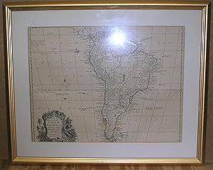
Map. Condition: VG. 1st Impression. This is a 21 1/2" X 18.00" Framed map that was originally Printed in 1 747 but has been updated several times through-out the late 18th Centu ry. This copy,though undated is very similar to the 1763 edition with a few variations. This copy makes note of a Sacrament Colony in the At lantic that… was ceded by Treaty to the Spainish by Portugal in 1750. T he cartouche in the left hand side is also different with a forest sce ne decoration. The Map is A VG or better copy, there are two light fo ld marks and mild tanning and offseting to the map. Overall clean an s harp. Comes matted in a glass frame. INTERNATIONAL CUSTOMERS, Please note that shipping costs will be determined on distance and the framed maps' weight of 4 1/2 pounds.

Published by London c.-47 1743
- Map
Seller: Robert Frew Ltd. ABA ILAB, London, , United KingdomRobert Frew Ltd. ABA ILAB
Contact seller5-star sellerCondition: Used
£ 125.00
£ 10.00 shippingShips from United Kingdom to U.S.A.Quantity: 1 available
Original copper engraved map depicting (35.5 x 43 cm, overall sheet 37 x 47 cm) depicting spain and portugal. With inset charts of the straits of Gibraltar and the harbour of Mahon (Minorca). With two vertical creases as issued. Decorative cartouche to upper right corner. Some light toning to right margin, not affecting map, ove…rall a very good example.
Published by W.Rayner, London 1737
- Map
Seller: Angelika C. J. Friebe Ltd. - MapWoman, Dorking, United KingdomAngelika C. J. Friebe Ltd. - MapWoman
Contact seller5-star sellerCondition: Used - Good
£ 150.00
£ 20.00 shippingShips from United Kingdom to U.S.A.Quantity: 1 available
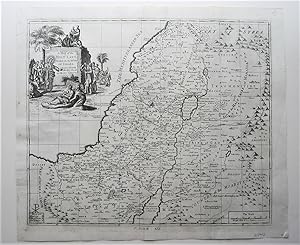
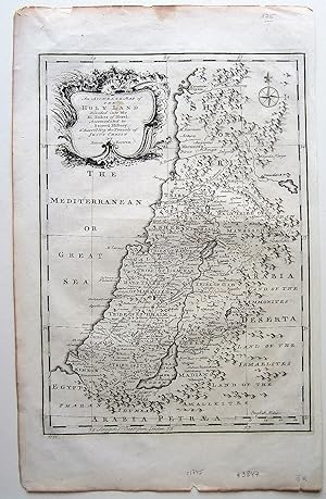
No Binding. Condition: Good. copper engraved map; overall 39 x 46 cm; plate 37 x 42 cm. folds as issued; additional creases; some stains; some marginal repairs; o/w g cond. An attractive map of the Holy Land, with a decorative cartouche and a scale of miles. Published in 'The Compleat History of the New and Old Testament:'.
Published by London 1744
- Map
Seller: Angelika C. J. Friebe Ltd. - MapWoman, Dorking, United KingdomAngelika C. J. Friebe Ltd. - MapWoman
Contact seller5-star sellerCondition: Used - Good
£ 300.00
£ 20.00 shippingShips from United Kingdom to U.S.A.Quantity: 1 available
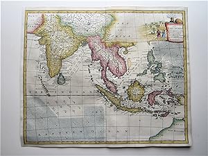
No Binding. Condition: Good. copper engr. map; overall 39 x 47 cm; image 37 x 45 cm. recent hand colouring; folds as issued; evenly toned; false left and right margin; some off-set ; signs of framing; repair to split in top c'fold; o/w g cond. A very detailed map of the East Indies with parts of Australia. Charming cartouche. E.… Bowen was one of the most prolific and important English map and print engravers and sellers of the 18th century. He was appointed Engraver of Maps to George II of England. Amongst his apprentices were Thomas Kitchin who later became his son-in-law and his son Thomas Bowen (c1732/3 1790). He worked closely together with John Owen and the Bowles family. This map stems from his atlas A Complete System of Geography and contained70 maps, published between 1744 and 1747.

Published by Londra 1748
- Art Print
Seller: libreria antiquaria perini Sas di Perini, Verona, VR, Italylibreria antiquaria perini Sas di Perini
Contact seller5-star sellerCondition: Used
£ 577.85
£ 34.52 shippingShips from Italy to U.S.A.Quantity: 1 available
Mm 285x585, dipinta a mano. Emanuel Bowen (1694?-1767) Ë stato un incisore e venditore di stampe britannico. Era noto soprattutto per i suoi atlanti e le sue mappe delle contee. Sebbene sia morto in povert?, la sua competenza era ampiamente riconosciuta e fu nominato cartografo sia da Giorgio II d'Inghilterra che da Luigi XV di…Francia. La sua attivit? fu portata avanti dal figlio Thomas Bowen. FormÚ anche molti apprendisti, due dei quali divennero cartografi di spicco, Thomas Kitchin e Thomas Jeffreys.Emanuel Bowen (1694?-1767) was a British engraver and print seller. He was most well-known for his atlases and county maps. Although he died in poverty, he was widely acknowledged for his expertise and was appointed as mapmaker to both George II of England and Louis XV of France. His business was carried on by his son, Thomas Bowen. He also trained many apprentices, two of whom became prominent mapmakers, Thomas Kitchin and Thomas Jeffreys. Nr.cat: Cod 7648.
Published by Printed for T. Woodward (and others), [London 1744
- Map
Seller: Michael Treloar Booksellers ANZAAB/ILAB, Adelaide, SA, AustraliaMichael Treloar Booksellers ANZAAB/ILAB
Contact seller5-star sellerCondition: Used - Very good
£ 3,247.08
£ 17.90 shippingShips from Australia to U.S.A.Quantity: 1 available
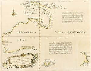
Condition: Very Good. [London, Printed for T. Woodward (and others), 1744]. A hand-coloured engraved map (visible image size 372 × 483 mm), recently mounted and matted just outside the printed border using archival materials (visible image size 372 × 483 mm, external mat size 545 × 643 mm), ready for framing (or long-term storag…e in its custom-made Mylar sleeve). A long sealed clean tear to the blank area in the bottom right-hand corner (mainly along the crease of the original fold); light central vertical crease; a few small insignificant light marks; in very good condition. The first dedicated English map of Australia, originally issued as part of the second edition of John Harris's 'Navigantium atque Itinerantium Bibliotheca, or, a Complete Collection of Voyages and Travels' (London, 1744-1748); 'Vol. 1, page 325' is printed in the top right-hand corner. Clancy ('So They Came South'), pages 136-37; Clancy ('Mapping of Terra Australis'), page 91; Tooley 241: 'A reissue of Thevenot's map of 1663 but with title as above within cartouche bottom right. Bowen inserts the Tropic of Capricorn and two long legends. The first one is very exactly copied from the original . The second legend is a long laudatory account of the presumed riches of Terra Australis'.
 More images
Published by London 1747
- Map
Seller: Jim Crotts Rare Books, LLC, Clemmons, NC, U.S.A.Jim Crotts Rare Books, LLC
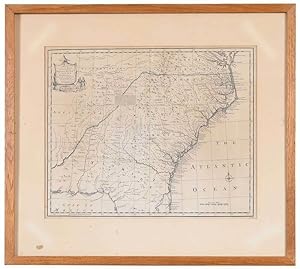
Contact seller2-star sellerEmanuel Bowen (1694-1767), A New & Accurate Map of the Provinces of North & South Carolina, Georgia, & C., London, circa 1747, in two sheets, engraving with minimal hand colored highlights, on laid paper, with title cartouche in the upper left corner, "No. 76" in lower right hand corner, plate 14 x 17-3/8 in., sheet 16-3/8 x 18-…1/2 in.; wood frame, 21-1/4 x 23-1/2 in. Map is taped in on matte at corners, joined at center, some light toning, especially at edges, separation at join lines near bottom edge; frame with light wear and abrasions.
 More images
Published by Laurie & Whittle, London 1794
- Map
Seller: Bjarne Tokerud Bookseller, Vancouver, BC, CanadaBjarne Tokerud Bookseller
Contact seller5-star sellerCondition: Used - Very good
£ 3,072.94
£ 14.92 shippingShips from Canada to U.S.A.Quantity: 1 available
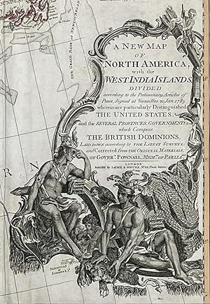
No Binding. Condition: Very Good. Available for shipping only in Canada as it is Framed. London: Laurie & Whittle, 1794 [c.1798]. A large wall map, 41.5" x 46". Contemporary colouring in outline. Near Fine. Engraved title cartouche includes a Native American family amidst furs, a parrot, and a monkey. Vertical crease on left sid…e, generally clean and very good. Conforms to Tooley's issue "l", on wove paper, with the Laurie and Whittle imprint at the bottom of the title cartouche, and the west coast of Newfoundland coloured blue, indicating French territory. This map was first issued about 1755 under the title: An Accurate Map of North America.This is the fourth version of the title. This version incorporates changes brought about by the American Revolution and the Treaty of Paris (1783). NOTE: THIS IS A VERY LARGE MAP and difficult to photograph in its entirety. Individual photographs with detail are available upon request.

Published by Bowen, [London 1747
Seller: Bartleby's Books, ABAA, Chevy Chase, MD, U.S.A.Bartleby's Books, ABAA
Contact seller5-star sellerEngraved map, 14 x 17 inches, with nice hand-coloring, from Bowen's Complete System of Geography, map "No. 76" at lower right. Cumming Southeast in Early Maps 263: "This is a copy of the Carolina sheet of Popple's great twenty-sheet map of North America (1733), with a separate title, reduced in size." Kendall Early Maps 40. Fold…ed; trimmed at plate mark on right edge, some offset, but very good.

- Softcover
- Print on Demand
Seller: Majestic Books, Hounslow, , United KingdomMajestic Books
Contact seller4-star sellerCondition: New
£ 27.16
£ 6.50 shippingShips from United Kingdom to U.S.A.Quantity: 4 available
Condition: New. Print on Demand pp. 170.

- Softcover
- Print on Demand
Seller: Majestic Books, Hounslow, , United KingdomMajestic Books
Contact seller4-star sellerCondition: New
£ 28.54
£ 6.50 shippingShips from United Kingdom to U.S.A.Quantity: 4 available
Condition: New. Print on Demand pp. 172.
 More images
- Map
Seller: Angelika C. J. Friebe Ltd. - MapWoman, Dorking, United KingdomAngelika C. J. Friebe Ltd. - MapWoman
Contact seller5-star sellerCondition: Used - Good
£ 175.00
£ 20.00 shippingShips from United Kingdom to U.S.A.Quantity: 1 available
No Binding. Condition: Good. copper engr. map; plate 32 x 23 cm; some stains; edges frayed with some smaller tears and paper loss; vertical printer's crease a long left margin; o/w g cond.- A very detailed map of the Holy Land, from Tripoli down to Gaza; Large, decorative cartouche.- E. Bowen was one of the most prolific and imp…ortant English map and print engravers and sellers of the 18th century. He was appointed Engraver of Maps to George II of England. Amongst his apprentices were Thomas Kitchin who later became his son-in-law and his son Thomas Bowen (c1732/3 - 1790). He worked closely together with John Owen and the Bowles family. This map stems from his atlas A Complete System of Geography and contained70 maps, published between 1744 and 1747.

- Map
Seller: Antique Paper Company, ASHFORD, KENT, United KingdomAntique Paper Company
Contact seller2-star sellerCondition: Used
£ 200.00
£ 6.00 shippingShips from United Kingdom to U.S.A.Quantity: 1 available
c1752 PARTICULAR DRAUGHTS of som of the chief AFRICAN ISLANDS in the MEDITERRANEAN as also in the ATLANTIC and ETHIOPIC OCEANS by Emmanuel Bowen.A fine map with inset maps of MALTA GOZO, CAPE VERDE, TENERIFE, ST HELENA, MADEIRA DUTCH FORT AT THE CAPE OF GOOD HOPE.Size approx 49cm x 38cm including margins. Condition is generally…good with folds as issued. There is some light spotting on the lower and right side margins.Emanuel Bowen (1714- 1767 in London) was an English map engraver, who worked for George II of England and Louis XV of France as a geographer. In spite of his royal appointments and apparent prosperity he died in poverty and his son, who carried on the business was no more fortunate and died in a Clerkenwell workhouse in 1790.Antique Paper Company are a long established family business selling original antique prints, maps engravings as well as many other paper antiques such as original vintage Decorative Posters, Ephemera, Stamps Postal History, Manuscripts, Antiquarian Books much more. We are always looking to buy and have up to andpound;500,000 in immediate funds available. We are looking for exceptional single items, better collections, original archives, Atlases, Libraries, accumulations etc and have previously purchased from Major Institutions, Libraries, Collectors, Solicitors many other sources. We are happy to travel almost anywhere in the world for the right opportunities. So please do get in touch if you are considering selling your Antique Paper collectables.
 More images
- Map
Seller: ROBIN RARE BOOKS at the Midtown Scholar, Harrisburg, PA, U.S.A.ROBIN RARE BOOKS at the Midtown Scholar
Contact seller5-star sellerNo Binding. Condition: Good. No Jacket. C. 1760 map of Belgium and the city of Mons by Emmanuel Bowen. Map and frame together measure approximately 22.5 x 18.75 . In good condition, with slight toning and wear to edges of map. Colors are preserve well and text is completely legible. Small dents and scuffing to frame. Map has not… been inspected outside of the frame. Please see photos and ask any questions prior to purchasing. Emmanuel Bowen (1694-1767) was a celebrated British mapmaker who served as the Royal Cartographer for both England and France. His maps were highly accurate for their day, and are constantly sought after by collectors.

- Map
Seller: Tmecca Inc., Seoul, , Korea, Republic ofTmecca Inc.
Contact seller2-star sellerCondition: Used - As new
£ 460.94
£ 14.91 shippingShips from Korea, Republic of to U.S.A.Quantity: 1 available
No Binding. Condition: As New. 24 x 28cm (Mer de Corée).


