
Order Total (1 Item Items):
Shipping Destination:

Blacks Picturesque Guide (18 results)
Skip to main search results
Search filters
Product Type
- All Product Types
- Books (1)
- Magazines & Periodicals (No further results match this refinement)
- Comics (No further results match this refinement)
- Sheet Music (No further results match this refinement)
- Art, Prints & Posters (12)
- Photographs (No further results match this refinement)
- Maps (5)
- Manuscripts & Paper Collectibles (No further results match this refinement)
Condition Learn more
- New (No further results match this refinement)
- As New, Fine or Near Fine (No further results match this refinement)
- Very Good or Good (2)
- Fair or Poor (No further results match this refinement)
- As Described (16)
Binding
- All Bindings
- Hardcover (1)
- Softcover (No further results match this refinement)
Collectible Attributes
- First Edition (No further results match this refinement)
- Signed (No further results match this refinement)
- Dust Jacket (No further results match this refinement)
- Seller-Supplied Images (17)
- Not Print on Demand (18)
Language (2)
Free Shipping
- Free Shipping to U.S.A. (No further results match this refinement)
Seller Location
Seller Rating
-
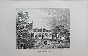
Single sheet. Original antique steel engraving. Buyers from outside the UK will have �3 refunded from the standard shipping charge. 16.5 x 11 cm.
-
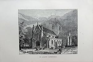
Single sheet. Original antique steel engraving. Buyers from outside the UK will have �3 refunded from the standard shipping charge. 16.5 x 11 cm.
-
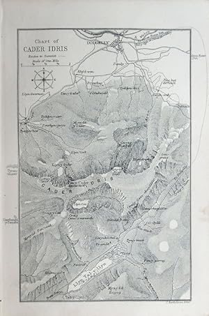
Single map. Original antique map. 11 x 14 cm.
-
No Binding. Condition: Very Good. Original antique map. Five folds as issued. One fold strengthened covering a small hole in a blank area, west of Wrexham. 37 x 14.5 cm.
-

Single sheet. Original antique wood engraving printed on a leaf from this guidebook (text verso). Crease across lower right margin. Buyers from outside the UK will have �3 refunded from the standard shipping charge. 16.5 x 11 cm.
-
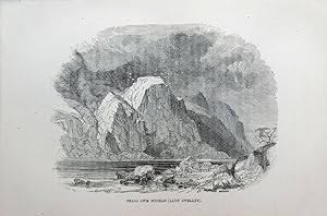
Wales - Snowdonia, (Eryri) -Craig Cwm Bychan (Llyn Cwellyn).
Publication Date: 1881
Art / Print / Poster
Single sheet. Original antique wood engraving printed on a leaf from this guidebook (text verso). A little off-setting. Buyers from outside the UK will have �3 refunded from the standard shipping charge. 16.5 x 11 cm.
-

Single sheet. Original antique steel engraving. Buyers from outside the UK will have �3 refunded from the standard shipping charge. 16.5 x 11 cm.
-

Single sheet. Original antique steel engraving. Buyers from outside the UK will have �3 refunded from the standard shipping charge. 16.5 x 11 cm.
-

Single map. Original antique map printed on a leaf from this guidebook (text verso). 8 x 13.5 cm.
-

Single sheet. Original antique steel engraving. Buyers from outside the UK will have �3 refunded from the standard shipping charge. 16.5 x 11 cm.
-

Single sheet. Original antique wood engraving printed on a leaf from this guidebook (text verso). Buyers from outside the UK will have �3 refunded from the standard shipping charge. 16.5 x 11 cm.
-

Single sheet. Original antique steel engraving. Buyers from outside the UK will have �3 refunded from the standard shipping charge. 16.5 x 11 cm.
-

Single map. Original antique map. Centrefold as issued. Closed split at the bottom of the fold. 18.5 x 14.5 cm.
-

Single sheet. Original antique steel engraving. Buyers from outside the UK will have �3 refunded from the standard shipping charge. 16.5 x 11 cm.
-

Single sheet. Original antique steel engraving. Buyers from outside the UK will have �3 refunded from the standard shipping charge. 16.5 x 11 cm.
-

Single map. Original antique map. Centrefold as issued. 18 x 14 cm.
-

Single sheet. Original antique steel engraving. Buyers from outside the UK will have �3 refunded from the standard shipping charge. 16.5 x 11 cm.
-

BLACK'S PICTURESQUE GUIDE TO THE ISLE OF WIGHT
Language: English
Published by Adam and Charles Black, Edinburgh, 1875
Seller: THOMAS RARE BOOKS, Yaxley, SUFFOLK, United Kingdom
Seller rating 4 out of 5 stars

Hardback. Condition: V.g. sixth edition. x, 85pp. Map end-paper Sketch Map of Hampshire. Frontis. plate of Osbourne House. 96pp. Ads. end-papers with vignette illus. of hotels etc.Loose folding map presnt complete but one section separate. No loss. Pub. original green pebble-grained cloth binding with gilt titles and crest to the front board. Gilt tiles to the spine. Rear end-papers list Blacks guide books.

