
Order Total (1 Item Items):
Shipping Destination:

Bartholomew Frgs (25 results)
Skip to main search results
Search filters
Product Type
- All Product Types
- Books (1)
- Magazines & Periodicals (No further results match this refinement)
- Comics (No further results match this refinement)
- Sheet Music (No further results match this refinement)
- Art, Prints & Posters (No further results match this refinement)
- Photographs (No further results match this refinement)
- Maps (24)
- Manuscripts & Paper Collectibles (No further results match this refinement)
Condition Learn more
- New (1)
- As New, Fine or Near Fine (No further results match this refinement)
- Very Good or Good (2)
- Fair or Poor (No further results match this refinement)
- As Described (22)
Binding
- All Bindings
- Hardcover (2)
- Softcover (No further results match this refinement)
Collectible Attributes
- First Edition (No further results match this refinement)
- Signed (No further results match this refinement)
- Dust Jacket (No further results match this refinement)
- Seller-Supplied Images (24)
- Not Print on Demand (24)
Language (2)
Free Shipping
- Free Shipping to U.S.A. (No further results match this refinement)
Seller Location
Seller Rating
-

Single sheet. Original antique coloured map showing the counties. Centrefold as issued. 22 x 29 cm.
-

Single sheet. Original antique coloured map showing the counties. Centrefold as issued. 22.5 x 29 cm.
-
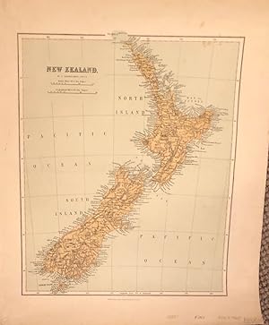
New Zealand
Language: English
Published by W R M McPhun & Son, Edinburgh
Seller: Anah Dunsheath RareBooks ABA ANZAAB ILAB, Auckland, NZ, New Zealand
Association Member: ABA ANZAAB ILAB
Seller rating 5 out of 5 stars

Map
No Binding. Condition: Very Good. Coloured map of New Zealand showing North and South Islands, showing cities, towns, rivers etc. 36 x 42 cm. c 1880.
-

Parliamentary Map of Northumberland and Durham.
Published by London: William Collins Sons & Co c, 1870
Seller: David Ford Books PBFA, Cley-next-the-Sea, United Kingdom
Association Member: PBFA
Seller rating 5 out of 5 stars
Map
Condition: Very Good. Coloured engraved map based on the 1868 Boundary Act and the Ordnance Survey; undated apart from that information. On paper laid onto linen, folding into 16 sections, with brown cloth sewn edges and brown paper backing to one section, attached inside green cloth-covered outer covers which have gilt title to front, and green linen ties. Scale 4 Miles to One Inch. Opened size: 72 x 57 cm. Very Good condition. Map face is largely clean and bright, with light browning in places, linen back has some brown spotting. A couple of folds have some lifting of the map joints. Neat gift inscription inside front cover. Covers have some surface marks and abrasions to corners.
-

Ports & Harbours on the East Coast of England.
Published by London Dublin and EdinburghA. Fullarton and Co. ., 1862
Seller: Robert Frew Ltd. ABA ILAB, London, United Kingdom
Association Member: ABA ILAB PBFA
Seller rating 5 out of 5 stars
Map
Original hand-coloured decorative lithographed map (overall 46 x 31 cm) Inset maps showing Mouth of the River Tyne with North & South Shields, Sunderland, Hartlepool and Mouth of the Tees, Whitby, Scarborough, Goole, Hull, Great Grimsby, and Harwich. The Royal Illustrated Atlas of Modern Geography.
-

Ports & Harbours on the North West Coast of England.
Published by London Dublin and EdinburghA. Fullarton and Co. ., 1862
Seller: Robert Frew Ltd. ABA ILAB, London, United Kingdom
Association Member: ABA ILAB PBFA
Seller rating 5 out of 5 stars
Map
Original hand-coloured decorative lithographed map (overall 46 x 31 cm) Inset maps showing Holyhead Harbour, Silloth Harbour & Docks, Plan of the Town & Borough of Liverpool with Birkenhead [.] New Brighton, Whitehaven, Lancaster, Environs of Liverpool and the Estuaries of the Mersey & Dee. Lower margin shaved with slight loss. The Royal Illustrated Atlas of Modern Geography.
-

Ports & Harbours on the South West Coast of England & Wales.
Published by London Dublin and EdinburghA. Fullarton and Co. ., 1862
Seller: Robert Frew Ltd. ABA ILAB, London, United Kingdom
Association Member: ABA ILAB PBFA
Seller rating 5 out of 5 stars
Map
Original hand-coloured decorative lithographed map (overall 46 x 31 cm) Inset maps showing Swansea, Milford Haven, Pembroke Dock, Cardiff, Bristol Channel, Newport Dock, Fishguard Bay, Bristol. Some margins tight. The Royal Illustrated Atlas of Modern Geography.
-
![Seller image for [Ports and Harbours on the East Coast of Scotland]. for sale by Robert Frew Ltd. ABA ILAB](https://pictures.abebooks.com/inventory/md/md32291215856.jpg)
[Ports and Harbours on the East Coast of Scotland].
Published by London Dublin and EdinburghA. Fullarton and Co. ., 1862
Seller: Robert Frew Ltd. ABA ILAB, London, United Kingdom
Association Member: ABA ILAB PBFA
Seller rating 5 out of 5 stars
Map
Original hand-coloured decorative lithographed map (overall 46 x 31 cm). Inset maps of Edinburgh and Leith & Granton, Peterhead, Aberdeen, Lower Estuary of the Forth and adjacent country. Lower margin shaved with slight loss. The Royal Illustrated Atlas of Modern Geography.
-

Central Europe with the Railways.
Published by London Dublin and EdinburghA. Fullarton and Co. ., 1862
Seller: Robert Frew Ltd. ABA ILAB, London, United Kingdom
Association Member: ABA ILAB PBFA
Seller rating 5 out of 5 stars
Map
Original hand-coloured lithographed map (overall 46 x 56.5 cm). The Royal Illustrated Atlas of Modern Geography.
-

French Ports & Harbours, and Plan of Paris.
Published by London Dublin and EdinburghA. Fullarton and Co. ., 1862
Seller: Robert Frew Ltd. ABA ILAB, London, United Kingdom
Association Member: ABA ILAB PBFA
Seller rating 5 out of 5 stars
Map
Original hand-coloured decorative lithographed map (overall 46 x 31 cm). Inset maps of Boulogne, Le Havre, Cherburg, Brest, Toulon Harbour, Marseilles, [Plan] Paris and its surrounding fortifications. Some margins tight of slightly shaved. The Royal Illustrated Atlas of Modern Geography.
-

Channel Islands, Scilly Islands, and Isle of Man.
Published by London Dublin and EdinburghA. Fullarton and Co. ., 1862
Seller: Robert Frew Ltd. ABA ILAB, London, United Kingdom
Association Member: ABA ILAB PBFA
Seller rating 5 out of 5 stars
Map
Original hand-coloured lithographed map (overall 46 x 31 cm). The Royal Illustrated Atlas of Modern Geography.
-

Africa.
Published by London Dublin and EdinburghA. Fullarton and Co. ., 1862
Seller: Robert Frew Ltd. ABA ILAB, London, United Kingdom
Association Member: ABA ILAB PBFA
Seller rating 5 out of 5 stars
Map
Original hand-coloured lithographed map (overall 46 x 56.5 cm). Inset maps of Cape Colony and Vicinity, Mauritius, the regions around the Delta of the Niger on an enlarged scale. The Royal Illustrated Atlas of Modern Geography.
-
![Seller image for Islands of Japan [Mandshuria, the Kurile Isles &c]. for sale by Robert Frew Ltd. ABA ILAB](https://pictures.abebooks.com/inventory/md/md32291230973.jpg)
Islands of Japan [Mandshuria, the Kurile Isles &c].
Published by London Dublin and EdinburghA. Fullarton and Co. ., 1862
Seller: Robert Frew Ltd. ABA ILAB, London, United Kingdom
Association Member: ABA ILAB PBFA
Seller rating 5 out of 5 stars
Map
Original hand-coloured decorative lithographed map (46 x 31 cm). Inset map of the Port of Nagasaki in the island of Kiou-sion. Three lovely vignettes accompany the map; a view of the Port of Simoneseke, Japanese nobleman & fisherman, and Japanese women of the higher and lower class. Left and lower margins are very tight. The Royal Illustrated Atlas of Modern Geography.
-

South American States. new Granada & Venezuela.
Published by London Dublin and EdinburghA. Fullarton and Co. ., 1862
Seller: Robert Frew Ltd. ABA ILAB, London, United Kingdom
Association Member: ABA ILAB PBFA
Seller rating 5 out of 5 stars
Map
Original hand-coloured lithographed map (overall 46 x 56.5 cm). Inset continuation map of Panama. The Royal Illustrated Atlas of Modern Geography.
-
![Seller image for [London] Cities, Ports & Harbours. 1st Metropolitan District &c. for sale by Robert Frew Ltd. ABA ILAB](https://pictures.abebooks.com/inventory/md/md32291214916.jpg)
[London] Cities, Ports & Harbours. 1st Metropolitan District &c.
Published by London Dublin and EdinburghA. Fullarton and Co. ., 1862
Seller: Robert Frew Ltd. ABA ILAB, London, United Kingdom
Association Member: ABA ILAB PBFA
Seller rating 5 out of 5 stars
Map
Original hand-coloured lithographed map (overall 46 x 31 cm). Showing London Metropolitan Burghs and Southern & Eastern Environs, Estuary of the Thames and the Medway, Portland. The Royal Illustrated Atlas of Modern Geography.
-

British North America. British Columbia and Vancouver Island.
Published by London Dublin and EdinburghA. Fullarton and Co. ., 1862
Seller: Robert Frew Ltd. ABA ILAB, London, United Kingdom
Association Member: ABA ILAB PBFA
Seller rating 5 out of 5 stars
Map
Original hand-coloured lithographed map (overall 46 x 56.5 cm). The Royal Illustrated Atlas of Modern Geography.
-

Railway Map of the British Isles exhibiting all the Railways and Canals in England, Scotland & Ireland completed or in progress with their respective stations.
Published by London Dublin and EdinburghA. Fullarton and Co. ., 1862
Seller: Robert Frew Ltd. ABA ILAB, London, United Kingdom
Association Member: ABA ILAB PBFA
Seller rating 5 out of 5 stars
Map
Original hand-coloured lithographed map (overall 46 x 56.5 cm). Inset plans of Glasgow, Edinburgh, Manchester, Birmingham, Railways around London, Enlarged section of the South Yorkshire and Lancashire Districts. With reference tables. The Royal Illustrated Atlas of Modern Geography.
-

Northern Ports & Harbours in the United States.
Published by London Dublin and EdinburghA. Fullarton and Co. ., 1862
Seller: Robert Frew Ltd. ABA ILAB, London, United Kingdom
Association Member: ABA ILAB PBFA
Seller rating 5 out of 5 stars
Map
Original hand-coloured decorative lithographed map (overall 46 x 31 cm). Inset maps of Portland Harbour, Boston Harbour and Vicinity, [the] Hudson River, New York Harbour and Vicinity, Philadelphia, Baltimore. Some margins are very tight. The Royal Illustrated Atlas of Modern Geography.
-

Southern Ports & Harbours in the United States.
Published by London Dublin and EdinburghA. Fullarton and Co. ., 1862
Seller: Robert Frew Ltd. ABA ILAB, London, United Kingdom
Association Member: ABA ILAB PBFA
Seller rating 5 out of 5 stars
Map
Original hand-coloured decorative lithographed map (overall 46 x 31 cm). Inset maps of Washington, Beaufort Harbour NC, Mobile Bay, Charleston Harbour SC, Galveston Entrance TX, Delta of the Mississippi & Environs of New Orleans, Pensacola Bay FL, Key West Island FL. Left margin slim. The Royal Illustrated Atlas of Modern Geography.
-

South America including Chile & Part of Bolivia & Peru.
Published by London Dublin and EdinburghA. Fullarton and Co. ., 1862
Seller: Robert Frew Ltd. ABA ILAB, London, United Kingdom
Association Member: ABA ILAB PBFA
Seller rating 5 out of 5 stars
Map
Original hand-coloured decorative lithographed map (overall 46 x 31 cm). Highlighting the Peru and Bolivian Tablelands, Chile (Northern, Central and Southern Portions). Several lovely small decorative vignettes surround the maps; they include a panoramic view of Valparaiso, hunting Lamas, travelling to Santiago, Condors &c. Some margins are very tight. The Royal Illustrated Atlas of Modern Geography.
-

Caucausus & Crimea with the Northern Portions of The Black Sea & Caspian Seas.
Published by London Dublin and EdinburghA. Fullarton and Co. ., 1862
Seller: Robert Frew Ltd. ABA ILAB, London, United Kingdom
Association Member: ABA ILAB PBFA
Seller rating 5 out of 5 stars
Map
Original hand-coloured decorative lithographed map (overall 46 x 31 cm). Inset map of Sebastopol, and maps of the Crimea according to Huot & Demidoff and The Caucasus according to Prof. Dr. Karl Koch. The maps are surrounded by a panoramic view of the Port and Town of Sebastopol, and assorted vignettes that include a Circassian warrior and maiden, a Tartar peasant and a female of the Crimea. Lower margin slightly shaved. Left margin tight. The Royal Illustrated Atlas of Modern Geography.
-

Indian Archipelago compiled from the various surveys of the British & Dutch Governments.
Published by London Dublin and EdinburghA. Fullarton and Co. ., 1862
Seller: Robert Frew Ltd. ABA ILAB, London, United Kingdom
Association Member: ABA ILAB PBFA
Seller rating 5 out of 5 stars
Map
Original hand-coloured lithographed map (overall 46 x 56.5 cm). The Royal Illustrated Atlas of Modern Geography.
-

China.
Published by London Dublin and EdinburghA. Fullarton and Co. ., 1862
Seller: Robert Frew Ltd. ABA ILAB, London, United Kingdom
Association Member: ABA ILAB PBFA
Seller rating 5 out of 5 stars
Map
Original hand-coloured lithographed map (overall 46 x 56.5 cm). Inset maps of the island of Chusan, Estuary of the Canton River from HK to Canton. The Royal Illustrated Atlas of Modern Geography.
-

British Empire Throughout the World Exhibited in One View.
Published by London Dublin and EdinburghA. Fullarton and Co. ., 1862
Seller: Robert Frew Ltd. ABA ILAB, London, United Kingdom
Association Member: ABA ILAB PBFA
Seller rating 5 out of 5 stars
Map
Original hand-coloured decorative lithographed map (overall 46 x 56.5 cm). With Tables of British Possessions, Former and present British possessions highlighted in red,with and a delightful, large continuous illustration of the people's of the British Empire running the length of the lower margin. A few light spots, generally a very good example. The Royal Illustrated Atlas of Modern Geography. This is a highly decorative map of the British Empire by John Bartholemew, with British possessions coloured red. Ethnographic figures engraved by Andrew Thom surround the map, representing the inhabitants of each colony or dominion, whether settlers or indigenous to the region. The tables detail the total size and population of British possessions around the world, and the date of their acquisition.
-
the handy reference atlas of the world 1923 [leather Bound]
Publication Date: 2024
Leather Bound. Condition: New. Language: English. Language: English. Presenting an Exquisite Leather-Bound Edition, expertly crafted with Original Natural Leather that gracefully adorns the spine and corners. The allure continues with Golden Leaf Printing that adds a touch of elegance, while Hand Embossing on the rounded spine lends an artistic flair. This masterpiece has been meticulously reprinted in 2024, utilizing the invaluable guidance of the original edition published many years ago in 1923. The contents of this book are presented in classic black and white. Its durability is ensured through a meticulous sewing binding technique, enhancing its longevity. Imprinted on top-tier quality paper. A team of professionals has expertly processed each page, delicately preserving its content without alteration. Due to the vintage nature of these books, every page has been manually restored for legibility. However, in certain instances, occasional blurriness, missing segments, or faint black spots might persist. We sincerely hope for your understanding of the challenges we faced with these books. Recognizing their significance for readers seeking insight into our historical treasure, we've diligently restored and reissued them. Our intention is to offer this valuable resource once again. We eagerly await your feedback, hoping that you'll find it appealing and will generously share your thoughts and recommendations. Lang: - English, Pages: - 472, Print on Demand. If it is a multi-volume set, then it is only a single volume. We are specialised in Customisation of books, if you wish to opt different color leather binding, you may contact us. This service is chargeable. Product Disclaimer: Kindly be informed that, owing to the inherent nature of leather as a natural material, minor discolorations or textural variations may be perceptible. Explore the FOLIO EDITION (12x19 Inches): Available Upon Request. 472 472.

![Seller image for the handy reference atlas of the world 1923 [leather Bound] for sale by Gyan Books Pvt. Ltd.](https://pictures.abebooks.com/inventory/md/md31472598862.jpg)