Order Total (1 Item Items):
Shipping Destination:

Alphonsus Lasor Varea (6 results)
Skip to main search results
Search filters
Product Type
- All Product Types
- Books (2)
- Magazines & Periodicals (No further results match this refinement)
- Comics (No further results match this refinement)
- Sheet Music (No further results match this refinement)
- Art, Prints & Posters (1)
- Photographs (No further results match this refinement)
- Maps (3)
- Manuscripts & Paper Collectibles (No further results match this refinement)
Condition Learn more
- New (No further results match this refinement)
- As New, Fine or Near Fine (No further results match this refinement)
- Very Good or Good (No further results match this refinement)
- Fair or Poor (No further results match this refinement)
- As Described (6)
Binding
- All Bindings
- Hardcover (1)
- Softcover (No further results match this refinement)
Collectible Attributes
- First Edition (2)
- Signed (No further results match this refinement)
- Dust Jacket (No further results match this refinement)
- Seller-Supplied Images (5)
- Not Print on Demand (6)
Language (2)
Price
- Any Price
- Under � 20 (No further results match this refinement)
- � 20 to � 35 (No further results match this refinement)
- Over � 35
Free Shipping
- Free Shipping to U.S.A. (No further results match this refinement)
Seller Location
Seller Rating
-

Germania. Landkarte Mitteleuropas von Flandern im Westen bis Krakau im Osten und Venedig im S�den. Original-Kupferstich aus "Universus Terrarum Orbis Scriptorum Calamo Delineatus" 1713
Published by Padua: Baptista Conzatti ehemals Frambotti, 1713
Seller: historicArt Antiquariat & Kunsthandlung, Wiesbaden-Breckenheim, Germany
Seller rating 5 out of 5 stars

Map
1. Original-Kupferstich auf r�ckseitig bedrucktem B�ttenblatt mit dekorativ abgesetztem Plattenrand auf einer Buchseite, sehr detailreiche Karte, bildliche Darstellung (Plattenrand) ca. 14 x 18 cm, Blattgr��e ca. 33 x 21 cm (jeweils H�he x Breite), sauber und bemerkenswert gut erhalten, sehr selten 2100 gr.
-

Portugalliae Regnum.
Published by Padua. 1713, 1713
Seller: Peter Harrington. ABA/ ILAB., London, United Kingdom
Association Member: ABA ILAB PBFA
Seller rating 5 out of 5 stars
An interesting eighteenth century Italian map of Portugal, based on the much earlier late sixteenth century map by Porcacchi. It shows the country lying east to west. There is text on the reverse of the map. Size: 145 x 195 mm. Copperplate engraving with later hand colour. Good condition.
-

India Orientalis (map)
Published by Padua, 1713
Seller: Antipodean Books, Maps & Prints, ABAA, Garrison, NY, U.S.A.
Association Member: ABAA ANZAAB ESA ILAB
Seller rating 3 out of 5 stars

Condition: Good + overall. A woodblock map within a page of text, published by Lasor a Varea in 1713. The map encompasses China, Persia, India, all of South East Asia, Japan, the Phillipines, Japan, the NW coast of America and a large New Guinea and "Beach Pars contientis Australis" as per Marco Polo, ostensibly the tip of Northern Australia. 6 7/8 x 5 1/8" on a sheet 9x13". B&w as issued, map a light impression with some darker areas (coast of China and Borneo). Text with some light creasing, but good+ overall. A pleasant copy.
-
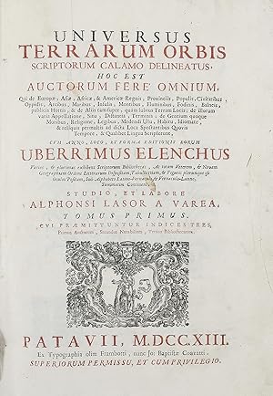
Universus terrarum orbis scriptorum calamo delineatus . qui de Europae, Asiae, Africae, & Americae regnis, provinciis, populis, civitatibus .
Publication Date: 1713
Seller: Maggs Bros. Ltd ABA, ILAB, PBFA, London, United Kingdom
Association Member: ABA ILAB PBFA
Seller rating 5 out of 5 stars
Map First Edition
First Edition; Folio (355 x 240 mm); 2 vols., titles printed in red and black with printer?s device, half-titles, 499 engraved maps, plans and prospects, most set in the text, eleven additional engraved plates and three leaves bearing twenty-four costume figures. Original pale grey paper boards, glazed paper spines, ms. titling to both spines; boards and spines darkened and discoloured by ingrained dust, joints beginning to split in places but still very firm. Padua : Giovanni Battista Conzatti, Alphonsus Lasor a Varea was the nome-de-plume of Raffaello Savonarola (d. 1748), a close anagram of his name. The Universus terrarum orbis scriptorum . was a historicogeographical and religious dictionary of the world, extensively illustrated with small format illustrations. Interestingly, and remarkably, the maps, plans and prospects that appear were printed from plates engraved at least a hundred years earlier, and some even earlier. The principal sources are Tomaso Porcacchi?s Le Isole pi� famose del Mondo, 1572, Giovanni Antonio Magini?s edition of Ptolemy?s Geografia, 1596, Nicolo Valegio?s Raccolta di le piu illustri et famose Citta di Tutto il Mondo [ca. 1595] and Giuseppe Rosaccio?s Viaggi a Costantinopoli, 1598. References: Sabin 39133; Shirley, T.LAS-1a.
-

Bopart. Boppardia, urbs Germaniae ad Rhenum fluvium, in ditione Electoris Trevirensis. Gesamtansicht der Stadt Boppard mit Festungsmauern am Rhein. �lteste bekannte Stadtansicht von Boppard. Kupferstich aus "Universus Terrarum Orbis Scriptorum Calamo Delineatus" 1713
Language: Latin
Published by Padua: Baptista Conzatti ehemals Frambotti, 1713
Seller: historicArt Antiquariat & Kunsthandlung, Wiesbaden-Breckenheim, Germany
Seller rating 5 out of 5 stars
Art / Print / Poster First Edition
1. kleiner Original-Kupferstich auf r�ckseitig bedrucktem B�ttenblatt mit dekorativ abgesetztem Plattenrand, bildliche Darstellung (Plattenrand) ca. 9 x 13,5 cm, Blattgr��e ca. 13 x 22 cm (jeweils H�he x Breite), sauber und bemerkenswert gut erhalten, selten 2100 gr.
-
Moscovia.
Publication Date: 1713
Seller: Altea Antique Maps, London, United Kingdom
Association Member: ABA ILAB PBFA
Seller rating 5 out of 5 stars
Map
Padua: Lasor a Varea, 1713. Coloured. 85 x 135mm, set in a larger page of text, overall size 330 x 230 mm. An early plan of Moscow, first published c.1600, based on the Braun & Hogenburg map, with the buildings shown in perspective. On the verso is Magini's map of Russia, also coloured.