Order Total (1 Item Items):
Shipping Destination:

Weller, Edward (755 results)
Feedback
Skip to main search results
Search filters
Product Type
- All Product Types
- Books (272)
- Magazines & Periodicals (No further results match this refinement)
- Comics (No further results match this refinement)
- Sheet Music (No further results match this refinement)
- Art, Prints & Posters (3)
- Photographs (No further results match this refinement)
- Maps (479)
- Manuscripts & Paper Collectibles (1)
Condition Learn more
Collectible Attributes
Language (4)
Free Shipping
Seller Location
Seller Rating
-
![Stock image for The early history of the typewriter [HARDCOVER] for sale by Majestic Books](https://pictures.abebooks.com/isbn/9789332866867-uk-300.jpg)
Condition: New. pp. 91.
-

� 5.25
Convert currency� 5.13 shipping from U.S.A. to United KingdomQuantity: 1 available
Add to basketHardcover. Condition: Very Good. No Jacket. Weller, Wesla (illustrator). May have limited writing in cover pages. Pages are unmarked. ~ ThriftBooks: Read More, Spend Less 0.76.
More buying choices from other sellers on AbeBooks
New offers from � 109.72
Used offers from � 10.38
Also find Hardcover First Edition
-

The Pocket Atlas of Historical Geography, Consisting of Sixteen Maps
Seller: GreatBookPricesUK, Woodford Green, United Kingdom
Seller rating 5 out of 5 stars

� 13.33
Convert currencyFree shipping within United KingdomQuantity: Over 20 available
Add to basketCondition: New.
More buying choices from other sellers on AbeBooks
New offers from � 13.33
Used offers from � 15.86
Also find Softcover
-
The Early History of the Typewriter
Seller: GreatBookPricesUK, Woodford Green, United Kingdom
Seller rating 5 out of 5 stars
� 13.60
Convert currencyFree shipping within United KingdomQuantity: Over 20 available
Add to basketCondition: New.
More buying choices from other sellers on AbeBooks
New offers from � 13.60
Used offers from � 15.85
Also find Softcover
-
The Early History of the Typewriter (Classic Reprint)
Seller: PBShop.store UK, Fairford, GLOS, United Kingdom
Seller rating 5 out of 5 stars
PAP. Condition: New. New Book. Shipped from UK. Established seller since 2000.
-

The Student's Atlas of Physical Geography, by E. Weller, J. Bryce
Seller: Ria Christie Collections, Uxbridge, United Kingdom
Seller rating 5 out of 5 stars
� 16.73
Convert currencyFree shipping within United KingdomQuantity: Over 20 available
Add to basketCondition: New. In.
-

The Isle Of Man ( Bacon's New Scale Ordnance Atlas of the British Isles )
Published by George W Bacon, 1881
Language: English
First Edition
Condition: Very Good. 1st edition. Single sheet, VG. Sheet size 21 x 13.5 inches ( 53 x 34 cm ) original hand colouring, 1.75 miles to 1 inch, a fine copy. Single sheet from the 1881 edition of Bacon's New Scale Ordnance Atlas of the British Isles, showing the railways etc of the Island. 50 grams.
-

The Early History of the Typewriter (Classic Reprint)
Seller: PBShop.store UK, Fairford, GLOS, United Kingdom
Seller rating 5 out of 5 stars
HRD. Condition: New. New Book. Shipped from UK. Established seller since 2000.
-

Ferroelectricity.
Published by Elsevier Publishing Company, 1967
Language: English
Seller: books4less (Versandantiquariat Petra Gros GmbH & Co. KG), Welling, Germany
Seller rating 5 out of 5 stars
� 5.32
Convert currency� 9.51 shipping from Germany to United KingdomQuantity: 1 available
Add to basketgebundene Ausgabe. Condition: Gut. 318 Seiten; Der Erhaltungszustand des hier angebotenen Werks ist trotz seiner Bibliotheksnutzung sehr sauber. Es befindet sich neben dem R�ckenschild lediglich ein Bibliotheksstempel im Buch; ordnungsgem�� entwidmet. In ENGLISCHER Sprache. Sprache: Englisch Gewicht in Gramm: 820.
-

An Improved Dictionary English and French, and French and English, Drawn From the Best Sources Extant in Both Languages Classic Reprint
Seller: PBShop.store UK, Fairford, GLOS, United Kingdom
Seller rating 5 out of 5 stars
PAP. Condition: New. New Book. Shipped from UK. Established seller since 2000.
More buying choices from other sellers on AbeBooks
New offers from � 22.49
Used offers from � 39.47
Also find Softcover
-
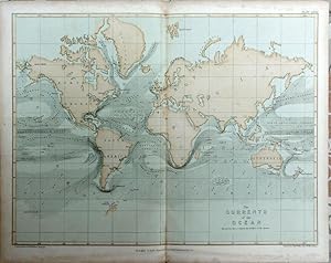
Ocean Currents
Published by Mid C19th
Seller: theoldmapman, Weston super Mare, United Kingdom
Seller rating 5 out of 5 stars
Map
Single sheet. An original antique coloured map. Centrefold as issued. 30 x 22 cm.
-
The Environs Of Edinburgh ( Bacon's New Scale Ordnance Atlas of the British Isles )
Published by George W Bacon, 1881
Language: English
First Edition
Condition: Very Good. 1st edition. Single sheet, VG. Sheet size 21 x 13.5 inches ( 53 x 34 cm ) original hand colouring, 2 miles to 1 inch, a fine copy. Single sheet from the 1881 edition of Bacon's New Scale Ordnance Atlas of the British Isles, showing the railways etc around Edinburgh, the coverage extending to Peebles in the south, Boness in the north, Kirktonhill in the east & Fauldhouse in the west. 50 grams.
-
DEVON, AN ANTIQUE MAP, CIRCA 1865
Published by CASSELL, PETTER & GALPIN, London, 1865
Language: English
Seller: K Books Ltd ABA ILAB, York, YORKS, United Kingdom
Association Member: ABA ILAB PBFA
Seller rating 5 out of 5 stars
First Edition
Single Sheet. Condition: Very Good. No Jacket. Edward WELLER (illustrator). First Edition. DEVON, AN ANTIQUE MAP, CIRCA 1865, AN ANTIQUE MAP, CIRCA 1865 MEASURES 25 X 16 INCHES, 63 X 43 CMS, GOOD CONDITION, WE PACK VERY WELL, TOO LARGE TO SEND MOUNTED SO DISPATCHED ROLLED IN A STRONG TUBE.SPLENDID VALUE --.
-

The Early History of the Typewriter
Seller: Ria Christie Collections, Uxbridge, United Kingdom
Seller rating 5 out of 5 stars
� 25.10
Convert currencyFree shipping within United KingdomQuantity: Over 20 available
Add to basketCondition: New. In.
-

The Pocket Atlas of Historical Geography, Consisting of Sixteen Maps
Seller: Ria Christie Collections, Uxbridge, United Kingdom
Seller rating 5 out of 5 stars
� 25.10
Convert currencyFree shipping within United KingdomQuantity: Over 20 available
Add to basketCondition: New. In.
-

Ferroelectricity
Seller: Zubal-Books, Since 1961, Cleveland, OH, U.S.A.
Seller rating 5 out of 5 stars
� 12.30
Convert currency� 13.34 shipping from U.S.A. to United KingdomQuantity: 1 available
Add to basketCondition: Good. 331 pp., hardcover, ex library else text clean & binding tight (lacks dust jacket). - If you are reading this, this item is actually (physically) in our stock and ready for shipment once ordered. We are not bookjackers. Buyer is responsible for any additional duties, taxes, or fees required by recipient's country.
-
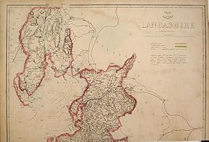
Lancashire, North
Publication Date: 1858
Seller: theoldmapman, Weston super Mare, United Kingdom
Seller rating 5 out of 5 stars
Map
Single sheet. Original outline colour. A large map for the Weekly Dispatch Atlas. This has been trimmed at the bottom inside the engraved area but reaches as far South as Fleetwood. At this time the county included what is now part of Cumbria from Ambleside to Barrow and Walney Island and Cartmell. Central East West crease. Priced to recognise its truncation and condition. 46 x 31 cm.
-

An Improved Dictionary: English and French, and French and English, Drawn From the Best Sources Extant in Both Languages (Classic Reprint)
Seller: PBShop.store UK, Fairford, GLOS, United Kingdom
Seller rating 5 out of 5 stars
HRD. Condition: New. New Book. Shipped from UK. Established seller since 2000.
-

The Student's Atlas of Physical Geography, by E. Weller, J. Bryce
Seller: Ria Christie Collections, Uxbridge, United Kingdom
Seller rating 5 out of 5 stars
� 26.74
Convert currencyFree shipping within United KingdomQuantity: Over 20 available
Add to basketCondition: New. In.
-
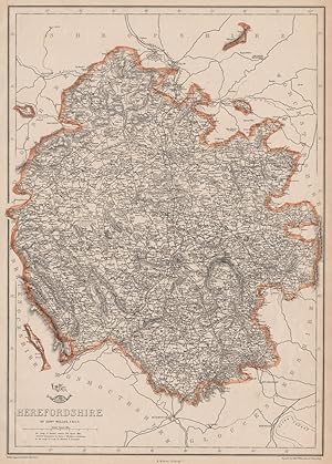
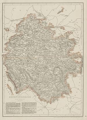
Condition: Good. HEREFORDSHIRE. Antique county map. Showing exclaves & railways. WELLER 1863. Antique map with original outline colour; Engraved by Edwd. Weller (1863). 44.0 x 31.5cm, 17.5 x 12.5 inches. Condition: Good. The image shown may have been taken from a different example of this map than that which is offered for sale. The map you will receive is in good condition but there may be minor variations in the condition from that shown in the image. This map was coloured by hand at the time of publication, thus the colouration may vary slightly between different examples of the map; the colouring applied to the map you receive may differ slightly from that shown in the image. There is nothing printed on the reverse side, which is plain.
-
Condition: Good. HEREFORDSHIRE antique county map. Showing railways & exclaves. WELLER 1863. Antique map with original outline colour; Engraved by Edwd. Weller (1863). 44.0 x 31.5cm, 17.5 x 12.5 inches. Condition: Good. The image shown may have been taken from a different example of this map than that which is offered for sale. The map you will receive is in good condition but there may be minor variations in the condition from that shown in the image. This map was coloured by hand at the time of publication, thus the colouration may vary slightly between different examples of the map; the colouring applied to the map you receive may differ slightly from that shown in the image. There is nothing printed on the reverse side, which is plain.
-
Monmouthshire And The River Wye ( Bacon's New Scale Ordnance Atlas of the British Isles )
Published by George W Bacon, 1881
Language: English
First Edition
Condition: Very Good. 1st edition. Single sheet, VG. Sheet size 21 x 13.5 inches ( 53 x 34 cm ) original hand colouring, 2.5 miles to 1 inch, a near fine copy. Single sheet map of the county of Monmouthshire, showing the railways, with the county divisions each a separate colour. 50 grams.
-
Wiltshire ( Bacon's New Scale Ordnance Atlas of the British Isles )
Published by George W Bacon, 1881
Language: English
First Edition
Condition: Very Good. 1st edition. Single sheet, VG. Sheet size 21 x 13.5 inches ( 53 x 34 cm ) original hand colouring, 3 miles to 1 inch, a near fine copy, small nick to one margin, not affecting the image. Single sheet map of the county of Wiltshire, showing the railways, and with each county division in a separate colour. 50 grams.
-
Cheshire ( Bacon's New Scale Ordnance Atlas of the British Isles )
Published by George W Bacon, 1881
Language: English
First Edition
Condition: Very Good. 1st edition. Single sheet, VG. Sheet size 21 x 13.5 inches ( 53 x 34 cm ) original hand colouring, 3 miles to 1 inch, a near fine copy. Single sheet map of the county of Cheshire, showing the railways, with the county divisions each a separate colour. 50 grams.
-
Cornwall ( Bacon's New Scale Ordnance Atlas of the British Isles )
Published by George W Bacon, 1881
Language: English
First Edition
Condition: Very Good. 1st edition. Single sheet, VG. Sheet size 21 x 13.5 inches ( 53 x 34 cm ) original hand colouring, 5 miles to 1 inch, a near fine copy. Single sheet map of the county of Cornwall, showing the railways, with the county divisions each a separate colour. 50 grams.
-
Warwickshire ( Bacon's New Scale Ordnance Atlas of the British Isles )
Published by George W Bacon, 1881
Language: English
First Edition
Condition: Very Good. 1st edition. Single sheet, VG. Sheet size 21 x 13.5 inches ( 53 x 34 cm ) original hand colouring, 3 miles to 1 inch, a fine copy. Single sheet map of the county of Warwickshire, showing the railways, and with each county division in a separate colour. 50 grams.
-
Bacon's Map of Scotland
Published by Bacon & Co, 127 The Strand, London
Seller: Books at yeomanthefirst, Folkestone, United Kingdom
Seller rating 5 out of 5 stars
Hardcover. Condition: Very Good. No Jacket. Map in hard covers, no date, circa 1880, green stamped boards with design in black to front and blind stamped to rear. Condition: Very Good minus. 26� x 25� when unfolded, previous owner�s name in pencil to inside front board, one or two panels browned, a couple of worn through points at folding intersections, otherwise clean and free from marking.
-
The Lakes Of Killarney And Surrounding Country ( Bacon's New Scale Ordnance Atlas of the British Isles )
Published by George W Bacon, 1881
Language: English
First Edition
Condition: Very Good. 1st edition. Single sheet, VG. Sheet size 21 x 13.5 inches ( 53 x 34 cm ) original hand colouring, 3 miles to 1 inch, a fine copy. Single sheet from the 1881 edition of Bacon's New Scale Ordnance Atlas of the British Isles, showing the railways etc around Killarney, coverage extending to Bantry in the south, Macroom in the east, Sneem in the west & Banteer in the north. 50 grams.
-
DORSET [DORCESTERSHIRE], AN ANTIQUE MAP, CIRCA 1865
Published by CASSELL, PETTER & GALPIN, London, 1865
Language: English
Seller: K Books Ltd ABA ILAB, York, YORKS, United Kingdom
Association Member: ABA ILAB PBFA
Seller rating 5 out of 5 stars
First Edition
Single Sheet. Condition: Very Good. No Jacket. Edward WELLER (illustrator). First Edition. DORSET [DORCESTERSHIRE], AN ANTIQUE MAP, CIRCA 1865 , AN ANTIQUE MAP, CIRCA 1865 .AN ANTIQUE MAP, CIRCA 1865 MEASURES 25 X 16 INCHES, 63 X 43 CMS, GOOD CONDITION, WE PACK VERY WELL, TOO LARGE TO SEND MOUNTED SO DISPATCHED ROLLED IN A STRONG TUBE.SPLENDID VALUE --.
-
NORTHER IRELAND, AN ANTIQUE MAP, CIRCA 1865
Published by CASSELL, PETTER & GALPIN, London, 1865
Language: English
Seller: K Books Ltd ABA ILAB, York, YORKS, United Kingdom
Association Member: ABA ILAB PBFA
Seller rating 5 out of 5 stars
First Edition
Single Sheet. Condition: Very Good. No Jacket. Edward WELLER (illustrator). First Edition. NORTHER IRELAND, AN ANTIQUE MAP, CIRCA 1865 MEASURES 25 X 16 INCHES, 63 X 43 CMS, GOOD CONDITION, WE PACK VERY WELL, TOO LARGE TO SEND MOUNTED SO DISPATCHED ROLLED IN A STRONG TUBE.SPLENDID VALUE --.