Order Total (1 Item Items):
Shipping Destination:

Bullock, L G (93 results)
Skip to main search results
Search filters
Product Type
- All Product Types
- Books (77)
- Magazines & Periodicals (No further results match this refinement)
- Comics (No further results match this refinement)
- Sheet Music (No further results match this refinement)
- Art, Prints & Posters (1)
- Photographs (No further results match this refinement)
- Maps (15)
- Manuscripts & Paper Collectibles (No further results match this refinement)
Condition Learn more
Binding
Collectible Attributes
- First Edition (6)
- Signed (No further results match this refinement)
- Dust Jacket (4)
- Seller-Supplied Images (52)
- Not Print on Demand (87)
Language (3)
Free Shipping
Seller Location
Seller Rating
-
paperback. Condition: Very Good. Connecting readers with great books since 1972! Used books may not include companion materials, and may have some shelf wear or limited writing. We ship orders daily and Customer Service is our top priority!
-
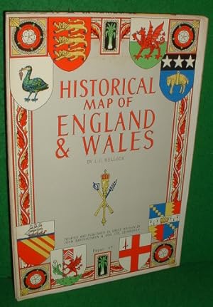
England and Wales Historical Map
Language: English
Published by John Bartholomew & Son Ltd.
ISBN 10: 0851525504 ISBN 13: 9780851525501
Seller: Wonder Book, Frederick, MD, U.S.A.
Seller rating 5 out of 5 stars

Condition: Good. Good condition. (England, Wales, Maps) A copy that has been read but remains intact. May contain markings such as bookplates, stamps, limited notes and highlighting, or a few light stains.
-
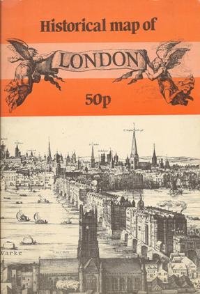
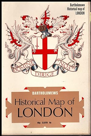
Historical Map of London
Seller: Oswestry Market Books, Oswestry, United Kingdom
Seller rating 5 out of 5 stars
Soft cover. Condition: Very Good. VG, no markings, no tears in original illd card covers.Guaranteed condition.
-

Condition: As New. Unread book in perfect condition.
-

-

Historical map of Ireland
Language: English
Published by John Bartholomew and Son Ltd, 1965
ISBN 10: 0851525512 ISBN 13: 9780851525518
Seller: Sequitur Books, Boonsboro, MD, U.S.A.
Association Member: IOBA
Seller rating 5 out of 5 stars
Map
Map. Condition: Good. [From the library of Monsignor John Louis FitzGerald.] Map. Shelf wear. Tears to edges. Tanning and foxing. Monsignor John Louis FitzGerald was a Baltimore native and former military chaplain who in 2003 established Apostleship of the Sea, a worldwide ministry for seafarers, for the Archdiocese of Baltimore.
-

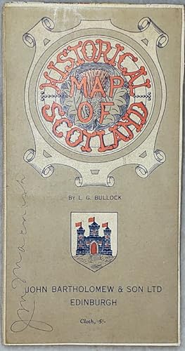
Historical Map of Scotland - 16 folded pages
Language: English
Published by John Bartholomew & Son Ltd, Edinburgh, Scotland
Soft cover. Condition: Very Good. No Jacket. Illustrated (illustrator). Unfolded, this map measures 39 x 26 inches.
-
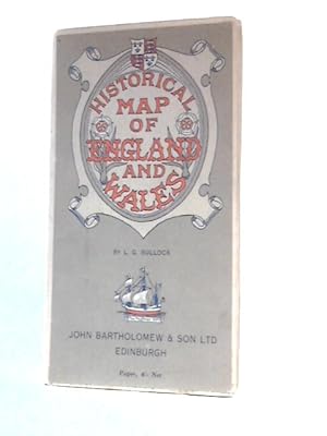
Historical Map of England and Wales
Published by John Bartholomew & Son Ltd, 1111
Seller: World of Rare Books, Goring-by-Sea, SXW, United Kingdom
Seller rating 5 out of 5 stars
Condition: Fair. No Edition Remarks. Unpaginated. Colour paper map with pictorial paper covers. Map has light tanning overall with small tears to edge of some creases, map remains unaffected. Paper cover has mild edgewear with curling to corners. Thumb-mark to front cover. Pen mark to rear cover.
-
Historical Map of England and Wales
Published by John Bartholemew and Son Ltd
Seller: Jt,s junk box, Newcastle, STAFF, United Kingdom
Seller rating 5 out of 5 stars
Map
Soft cover. Condition: Good. good condition.
-

Historical Map of Scotland:
Language: English
Published by Bartholomew UNBEKANNT., 1945
ISBN 10: 0851525687 ISBN 13: 9780851525686
Seller: ANTIQUARIAT F�RDEBUCH Inh.Michael Simon, Eckernf�rde, Germany
Seller rating 5 out of 5 stars
Broschiert, Karte. Condition: Gut. Auflage: Illustrated. Karte guter Zustand, Einband leicht berieben, engl sprachig LIEFERZEITEN / DELIVERY TIMES: DEUTSCHLAND 5 - 14 Tage EUROPA/EUROPE: 7 - 30 Tage/Days USA/WELTWEIT/WORLDWIDE: 14 - 60 Tage/Days (!!!) +++ Sprache: Englisch Gewicht in Gramm: 450.
-
Historical Map Of England And Wales
Language: English
Published by John Bartholomew & Son Limited, Edinburgh, Scotland, United Kingdom, 1971
ISBN 10: 0851525504 ISBN 13: 9780851525501
Seller: M. W. Cramer Rare and Out Of Print Books, Toronto, ON, Canada
Seller rating 4 out of 5 stars

Soft cover. Condition: Near Fine. First Thus. Full colour fold out map 39"x26" folded to 9 3/4 x 6 3/4.
-
London Historical Map by L G Bullock 1969
Language: English
Published by John Bartholomew & Son, Edinbutugh & London, 1969
ISBN 10: 0851525644 ISBN 13: 9780851525648
Map
Softcover Satin Finish. Condition: Fine. No Jacket. ## London Historical Map by L G Bullock 1969 ## ## THIS MAP: Classified FINE: This Map is the 1969 edition. Originally published in 1969. ## Bullock's Map of London is a historical map and a work of art. It combines accuracy with creative information with entertainment. It captures the essence and spirit of London uniquely. It is a map that invites curiosity and discovery. It is a map that celebrates London's past and present. In full colour and is unique. PLEASE READ FURTHER FOR A FULL DESCRIPTION ## ## London is rich in history, culture, and diversity. It has been the capital of England since the 12th century and has witnessed many events that shaped the nation and the world. London has always been at the forefront of change and innovation from the Roman invasion to the Norman conquest, from the Great Fire to the Blitz, from the Industrial Revolution to the Swinging Sixties.## ## One way to explore the fascinating past of London is to look at its historical maps. These maps not only show the city's physical layout but also reveal its social, political, and cultural aspects. They illustrate how London grew from a small settlement on the banks of the Thames to a sprawling metropolis that covers more than 600 square miles. They also depict how Londoners lived, worked, and played in different periods.## ## One of London's most interesting historical maps is the one drawn by Leslie Bullock in 1969. Bullock was a British illustrator and cartographer who specialised in pictorial maps. He created many maps of places in Britain and abroad, such as Scotland, Ireland, France, Italy, and Greece. His maps were colourful, detailed, and humorous, featuring historical figures, landmarks, legends, and anecdotes.## ## Bullock's Map of London is titled "Historical Map of London" and covers an area from Hampstead Heath in the north to Greenwich in the south and from Hammersmith in the west to Barking in the east. It shows London's main roads, railways, bridges, parks, and buildings in 1969 and includes many historical references from different eras. For example, it shows the Roman wall that surrounded Londinium, the medieval Tower of London and Westminster Abbey, the Tudor Hampton Court Palace and Shakespeare's Globe Theatre, the Georgian St Paul's Cathedral and Buckingham Palace, the Victorian Crystal Palace and Big Ben, and the modern Trafalgar Square and Piccadilly Circus. ## ## The Map also features many famous and infamous characters from London's history, such as Boudicca, King Alfred, William the Conqueror, Thomas Becket, Geoffrey Chaucer, Henry VIII, Elizabeth I, Oliver Cromwell, Samuel Pepys, Isaac Newton, Charles Dickens, Jack the Ripper, Winston Churchill, and The Beatles. Some characters are shown in their historical settings, while others are depicted in humorous situations or anachronisms. ## ## The Map also contains many coats of arms from London boroughs, districts, guilds, and institutions. These coats of arms represent the history and identity of each area or organisation. For example, the coat of arms of Westminster shows a portcullis (a gate) and two crossed swords (symbols of royal authority); the coat of arms of Camden shows three mullets (stars) and a chevron (a V-shaped stripe) from the Arms of Sir Charles Pratt (the first Earl Camden); the coat of arms of Hackney shows a pair of shaking hands (a sign of friendship) and three sheaves of wheat (a reference to agriculture); and the coat of arms of The City shows a dragon (a mythical creature) and a cross (a Christian symbol).## ### INTERNATIONAL BUYERS: Please Note FREE SHIPPING IS UK ONLY. Please get in touch with me for a shipping quotation. ###.
-

Historical Map of Scotland
Language: English
Published by Bartholomew, Edinburgh, MA, 1969
ISBN 10: 0851525520 ISBN 13: 9780851525525
Paperback. Condition: Very Good. 1969. Nice Firm Clean copy ! 1 pages. 6181L.
-

Condition: Good. Most items will be dispatched the same or the next working day. A copy that has been read but remains in clean condition. All of the pages are intact and the cover is intact and the spine may show signs of wear. The book may have minor markings which are not specifically mentioned. A good condition book. A later reprint, potentially circa 1980s, with '50p' printed on the bottom of the cover page. A clean, tidy and vibrant copy.
-
![Stock image for Bartholomews Historical Map of London [on cloth] for sale by Antiquarius Booksellers](https://pictures.abebooks.com/isbn/9780851525648-uk-300.jpg)
Bartholomews Historical Map of London [on cloth]
Language: English
Published by John Bartholomew & Son, Edinburgh, 1969
ISBN 10: 0851525644 ISBN 13: 9780851525648
No Binding. Condition: Fine. 1969 Edition. A brightly coloured pictorial map drawn by Leslie Bullock. It illustrates places and characters in history and is decorated with the coats of arms of the London Guilds, Districts etc. This map is mounted on cloth and shows no wear except for a couple of tiny pin-holes in the margins. Folds to approx 7" by 10" with colourful card covers. Ships via inexpensive Canada Post Lettermail, or via the USPS Media Mail, within North America, in card sleeve. From $5.00 to $8.00 depending on exact weight etc. Those requiring Tracking in Canada will find postage considerably more. Tracking with all shipments to the USA. Image available if required. Overseas orders, Postage, at cost, determined by final weight and destination.
-

Historical Map of Scotland
Language: English
Published by John Bartholomew & Son Ltd., 1945
ISBN 10: 0851525687 ISBN 13: 9780851525686
Seller: A Wigtown Book, Kirkinner, GALLO, United Kingdom
Seller rating 1 out of 5 stars

-
HISTORICAL MAP OF SCOTLAND
Language: English
Published by John Bartholomew & Son Ltd, 1970
Seller: Sequitur Books, Boonsboro, MD, U.S.A.
Association Member: IOBA
Seller rating 5 out of 5 stars
Paperback. Condition: Very Good. Large fold out map. Wear to edges.
-
Card Soft Cover. Condition: Very Good. Large fold-out map with card cover. Size: Large Octavo.
-
HISTORICAL MAP OF SCOTLAND
Language: English
Published by JOHN BARTHOLOMEW & SON LTD, EDINBURGH
Seller: COOK AND BAKERS BOOKS, PARKSVILLE, VANCOUVER ISLAND, BC, Canada
Seller rating 5 out of 5 stars
Map
Soft cover. Condition: Very Good. Price sticker scar on front cover of map. Folded size: 4.5 X 8.5" un-folded: 26" wide X 37" tall. Printed on Cloth - Revised in 1952. Shows: Cathedrals & Abbeys; Battles & Massacres; Castles & Resorts; Towns, Ports, Roads; Scenic & Historic Features. Decorated with the clan Coats of Arms.
-
HISTORICAL MAP OF ENGLAND & WALES
Language: English
Published by JOHN BARTHOLOMEW, EDINBURGH
Seller: Happyfish Books, Meopham, KENT, United Kingdom
Seller rating 4 out of 5 stars
Soft cover. Condition: Good. No Jacket. * PUBLISHER : JOHN BARTHOLOMEW * YEAR : UNDATED * ISBN : N/A * No OF PAGES : * CONDITION : USED - GOOD * OTHER: THIS BOOK OPENS UP INTO AN HISTORICAL MAP OF ENGLAND AND WALES. THE MAP IS PRINTED ON CLOTH AND NOT PAPER. THE COVER IS LIGHTLY RUBBED AND CREASED WITH MILD BUMPING AND TANNING ALONG THE EDGES AND CORNERS. THE MAP IS CLEAR AND CRISP. PAGES GENERALLY APPEAR CLEAN AND CREASE FREE. ALL IN ALL A NICE EXAMPLE OF THIS BOOK.
-

Doctors of Another Calling: Physicians Who Are Known Best in Fields Other than Medicine
Language: English
Published by University of Delaware Press, 2013
ISBN 10: 1611494664 ISBN 13: 9781611494662
Seller: A Squared Books (Don Dewhirst), South Lyon, MI, U.S.A.
Seller rating 5 out of 5 stars
hardcover. Condition: As New. Newark, 2013; illustrated cloth covered boards; minimal shelf wear; 8vo - over 7 3/4" to 9 3/4" tall; Interior is clean and unmarked; 477 pages;
-
Historical Map of SCOTLAND by L G Bullock 1969 - FULL COLOUR Cloth Map
Language: English
Published by John Bartholomews & Son Ltd, Edinburgh Scotland, 1969
Map
Soft cover. Condition: Very Good. No Jacket. ## Historical Map of SCOTLAND by L G Bullock 1969 - FULL COLOUR Cloth Map ### 7 ## THIS MAP: Classified as VERY GOOD, it is the 1969 Edition. The map was first published in Great Britain in 1969. Printed in full colour, measuring 26� Inches by 30 inches (678cm x 762cm) ### We provide images to all our books and maps so you know what you buy. READ ON for more information and details. ## # ## The Historical Map of Scotland, created by L. G. Bullock in 1969, is a full-colour cloth map that is a treasure trove of historical and geographical insights, capturing Scotland's rich past and diverse landscapes. ### Overview: The Historical Map of Scotland is a visual masterpiece that unfolds Scotland's story across time and space. Here are the key features that make this map a must-have for history enthusiasts:## 1. Vivid Color Palette: - The map is a riot of colours, vividly portraying Scotland's varied regions, from the Highlands to the Lowlands. Each hue represents a different historical era, allowing viewers to trace the evolution of Scotland over centuries.## 2. Geographical Details: - The map meticulously outlines towns, roads, cathedrals, abbeys, royal burghs, and ancient Roman sites. Castles, resorts, and seaports dot the landscape, providing a glimpse into Scotland's architectural heritage.## 3. Historical Significance:- Major battles, sieges, and massacres are marked along with the corresponding years on the map. ## Imagine standing on the very ground where these pivotal events unfolded! ### Exploring the Map: 1. Towns and Cities:- Discover Scotland's bustling towns and cities, each with unique character and history. From Edinburgh's regal charm to Glasgow's industrial prowess, the map celebrates urban life.## 2. Ancient Sites:- Follow the ancient Roman roads and explore the remnants of their civilisation. Visit abbeys and cathedrals that have witnessed centuries of worship and cultural exchange.## 3. Castles and Strongholds:- Scotland is synonymous with castles, and this map highlights their strategic locations. Feel the echoes of medieval knights and noble families as you trace their ancestral homes.## 4. Battlefields and Sieges: - Stand where armies clashed, where freedom was won or lost. The map reveals the scars of conflict, reminding us of Scotland's resilience. ## ### Collector's Item: The Historical Map of Scotland is more than a navigational guide; it's a piece of art. Whether displayed on your study wall or carefully folded in a drawer, it invites you to explore Scotland's past and connect with its people.## ### Conclusion: L. G. Bullock's creation invites us to step back in time, traverse Scotland's rugged terrain, and immerse ourselves in its captivating history. Unfold this cloth map, and let its colours and contours transport you to a bygone era. ## ## INTERNATIONAL BUYERS: Please Note. FREE SHIPPING IS UK ONLY. Please get in touch with me for a shipping quotation. No Author signature.
-

Condition: Good. Most items will be dispatched the same or the next working day. A copy that has been read but remains in clean condition. All of the pages are intact and the cover is intact and the spine may show signs of wear. The book may have minor markings which are not specifically mentioned. A few small stains.
-
Historical Map of Scotland
Published by John Bartholomew & Son LTD, Edinburgh
Seller: Lloyd Zimmer, Books and Maps, Chanute, KS, U.S.A.
Seller rating 5 out of 5 stars
Paper. Condition: Very Good. Dust Jacket Condition: No Dust Jacket. Bright and attractive, undated, folding map, circa 1950? Paper backed on linen, measuring 26 x 38 inches (66 x 97 cm). Previous owner's name is seen on the front panel. Otherwise a clean and intact copy.
-
Historical Map of England and Wales
Published by John Bartholomew & Co., 1111
Seller: World of Rare Books, Goring-by-Sea, SXW, United Kingdom
Seller rating 5 out of 5 stars
Condition: Fair. No Edition Remarks. Unpaginated. Colour paper map with pictorial paper covers. Paper map has light tanning overall. Tears to edges and top panel. Paper cover has mild edgewear with curling to corners. Light tanning to edges.
-
Historical Map of Scotland (revised 1952)
Published by John Bartholomew and Son, 1952, 1952
Condition: near fine. Pbk folding map illustr in color very faint shelfwear to card covers otherwise an excellent clean unmarked copy.
-
HISTORICAL MAP OF ENGLAND AND WALE , Bartholomew Pictorial and Historical Maps Series
Language: English
Published by JOHN BARTHOLOMEW Publishers & Printers, EDINBURGH, 1965
ISBN 10: 0851525687 ISBN 13: 9780851525686
Paper Back. Condition: Very Good. Illustrated card covers, 250x 170 mm approx. Educational " Wall Poster size map" comprising one folded sheet illustrated in colour with Places & Characters in History, City Coats of Arms etc. First Printing 1965 Cover price 4s. Very Good (Covers - a little dust spotting to front cover, map face clean, no previous owner name of insc. 17mm approx tear to margin of one fold. No other notable defects). Please see our images of the actual Map offered for sale.
-
good large colourful wall map with many historical events and crests of various places.
-

HISTORICAL MAP OF SCOTLAND
Language: English
Published by John Bartholomew & Son Ltd, 1985
ISBN 10: 0851525687 ISBN 13: 9780851525686
Seller: Herr Klaus Dieter Boettcher, Karlsruhe, BW, Germany
Seller rating 4 out of 5 stars
Softcover/Paperback. Condition: Gut. Very colourful, fold-out historical map of Scotland. Undated but probably 1980's? Size: 39 in. x 26 in. Sprache: Englisch Gewicht in Gramm: 550.
-

Konvolut mit 3 Teilen/3 vols.: Historical map of Scotland / of Ireland / of England and Wales.
Language: English
Published by Edinburgh, John Bartholomew, 1971, 1971
Seller: Antiquariat Carl Wegner, Berlin, B, Germany
Association Member: GIAQ
Seller rating 5 out of 5 stars
First Edition
Softcover. 4�, 25 x 17 cm. Three original cardboard boxes, each containing a fold-out color map measuring 100 x 67.5 cm, with numerous coats of arms drawings along the edges. The covers are somewhat dusty, and the front cover contains a short handwritten addition to the title (England: City Coats of Arms / Scotland: Clans and Cities / Ireland: Cities). The interior is clean. Good overall condition. -- Drei Original-Kartonagen, im Inneren befindet sich jeweils eine ausfaltbare farbige Karte im Format 100 x 67,5 cm, an den R�ndern mit zahlreichen Wappenzeichnungen. Die Deckel sind etwas angestaubt, Vorderseite jeweils mit kurzer handschriftlicher Erg�nzung zum Titel (England: Stadtwappen / Scotland: Clans u. St�dte / Ireland: St�dte). Innen sauber. Guter Gesamtzustand. -- Bitte Portokosten au�erhalb EU erfragen! / Please ask for postage costs outside EU! / S ' il vous plait demander des frais de port en dehors de l ' UE! // Bitte beachten Sie auch unsere Fotos! / Please also note our photos! / Veuillez noter nos photos -- Lesen Sie etwas Sch�nes auf einer Bank in der Fr�hlingssonne! Wir haben die passende Lekt�re. -- Wir kaufen Ihre werthaltigen B�cher! K00146-436379.